Request for Floodplain Advice and Information
advertisement
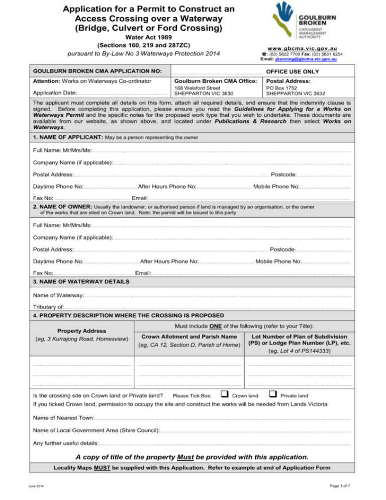
Application for a Permit to Construct an Access Crossing over a Waterway (Bridge, Culvert or Ford Crossing) Water Act 1989 (Sections 160, 219 and 287ZC) pursuant to By-Law No 3 Waterways Protection 2014 GOULBURN BROKEN CMA APPLICATION NO: www.gbcma.vic.gov.au : (03) 5822 7700 Fax: (03) 5831 6254 Email: planning@gbcma.vic.gov.au ……………………………………………………….……. OFFICE USE ONLY Attention: Works on Waterways Co-ordinator Goulburn Broken CMA Office: Postal Address: Application Date:.……………………………........…..………..…..……… 168 Welsford Street SHEPPARTON VIC 3630 PO Box 1752 SHEPPARTON VIC 3632 The applicant must complete all details on this form, attach all required details, and ensure that the indemnity clause is signed. Before completing this application, please ensure you read the Guidelines for Applying for a Works on Waterways Permit and the specific notes for the proposed work type that you wish to undertake. These documents are available from our website, as shown above, and located under Publications & Research then select Works on Waterways. 1. NAME OF APPLICANT: May be a person representing the owner Full Name: Mr/Mrs/Ms:….…………….………………………………..……………………………………………..….……………………………………….………………..…….….…….… Company Name (if applicable):….…………………………………...…………….…….…………………….…………………….…………..…..……………………………...………… Postal Address:…………………………………………………………………………………..………..…………….…………..……….....… Postcode:…….….……………...……..…… Daytime Phone No:................................................. After Hours Phone No:................................................... Mobile Phone No:............................................... Fax No:…..………………..……………………....…….. Email:……………..………………………………...………………………………………...…….…………………….…………….…… 2. NAME OF OWNER: Usually the landowner, or authorised person if land is managed by an organisation, or the owner of the works that are sited on Crown land. Note: the permit will be issued to this party Full Name: Mr/Mrs/Ms:….…………….………………………………..……………………………………………………………………...….………………………………..…….….…….… Company Name (if applicable):….…………………………………...…………….…….……………………………..…………….…………………….…………..…..……….………… Postal Address:……………………………………………………………………………..……………..……………………..………….....… Postcode:…..….………….………..…..…… Daytime Phone No:................................................... After Hours Phone No:................................................... Mobile Phone No:............................................. Fax No:…..…………………...…….…………..…...…….. Email:…………………...……….….……….……………………………………………...…….…………………….…………….…… 3. NAME OF WATERWAY DETAILS Name of Waterway:….………………………………………………….……………………………….…………………..….…………………..………………………….………………...….… Tributary of:…………....………….…………………………………….…………………………………….………………………………………….………………………………………….….…… 4. PROPERTY DESCRIPTION WHERE THE CROSSING IS PROPOSED Property Address (eg, 3 Kurrajong Road, Homesview) Must include ONE of the following (refer to your Title): Crown Allotment and Parish Name (eg, CA 12, Section D, Parish of Home) Lot Number of Plan of Subdivision (PS) or Lodge Plan Number (LP), etc. (eg, Lot 4 of PS144333) ……………………………………………………..……..….… …………………………………………………………….…….…. ………………………………………………….….…….………… ..………………………………...……………..……………..… ……………………………………..………………………...….…. ……………………………………………………..…….………… ……………………………………………...……………..…… ………………………………………………………………...…… ……………………………………………………………….…….. Is the crossing site on Crown land or Private land? Please Tick Box: Crown land Private land If you ticked Crown land, permission to occupy the site and construct the works will be needed from Lands Victoria Name of Nearest Town:……………………………………………………………………………………..………….………………..….………....……..……………..……………..………. Name of Local Government Area (Shire Council):…………………………………………………………………………..……..…..……………..…….……………….……. Any further useful details:………………………………………................................................................................................................................................................................... A copy of title of the property Must be provided with this application. Locality Maps MUST be supplied with this Application. Refer to example at end of Application Form June 2014 Page 1 of 7 5. GENERAL DESCRIPTION OF THE PROPOSED CROSSING SITE 5A. Proposed use, description and cost of works Purpose use:……………..………………….…….………………………………..………………..…….………………………………………………….…………………………………………… …………………………………………………………………………………………..…………..………………………………………………………………….…………….……………..……..………… Brief description of works:…….………………….……………………………..……….……..………………………….…………………………………………….…………………..……. ……………………………………….………….……………………………………..……………..………………………………………………………………………………………...………………..…. ……………………………………….….……………………………………………....……………………………………..………………………….…..……………………………..….…………….……. ……………………………………….………………………………….……………..………………………………………………….…….….….………………………………………………………….... Estimated cost of works: $ .................................. 5B. Waterway Dimensions How wide is the waterway? Distance between top of waterway banks…………………...….…….…..metres Distance across waterway bed……………………..…………………………….metres How high is the waterway? Height to top of waterway bank above waterway bed level looking downstream: Left bank:……………….…………metres, Right bank:………………..…………metres Please sketch the waterway cross section showing the above dimensions on Page 5 (Section 13). 5C. Describe any erosion and vegetation details Is there evidence of erosion in the bed and banks of the waterway? Please Tick Box: Yes No Please Comment:…………………………………………….………………………………………………………………………..…………………………………………………….…..……… ……………………………………………………………………………………………………………………………………………………………………………………………………………..….…...… …………………………………………………………………………………………………………………………………………………………………………………………………………………..…… Describe the type and extent of existing vegetation on the bed and banks of the waterway at the proposed crossing site. a) Bed: ………………………………………………………………………………………………………………………..……………………………………………………………………………… ……………………………….………….……………………………………………………………………………………..…………………………………………………………………..… ………………………………………………………………………………………………………………………………………………………………………………………………...…..…. b) Banks:….………………………………………………………………………………………….………………………………………………………………….………………………………..…… ……………….……………………………………………………………………………………………………………………...…………………………………………………….……….... ……………………………………………………………………………………………………………………………………………………………………………………………………….. 5D. Describe the soil type of the bed and banks BED of the waterway: Please tick appropriate box Clay Soil Sand Gravel Rock Other (Please Specify): ……………………………………………………..………………...………………………………………….…………….………………… ………….…………………………………………………………………………………………….………………………….…….………….…………………………………. BANKS of the waterway: Please tick appropriate box Clay Soil Sand Gravel Rock Other (Please specify): …………………………….………………………………………..……..…..…………………………………………….…………………… ……………….……………………………………………………………………………………………..…..……………………………………………………………………. Page 2 of 7 6. CROSSING DETAILS (Please Complete 6A or 6B or 6C) 6A. Bridge Crossing Proposed Bridge Dimensions: Total Length:…………..………….………………………………………metres Bridge Width:…………………………………………………….……….metres Number of Spans: Please Tick Box: Single Span Two Spans Three Spans Four Spans Other:…………………………………………………………………………………………………………………………………………………………….…..………………..…………………… Proposed Material: Please Tick those that is appropriate Concrete Steel Timber Other (please specify): ……………………………………………………………………..……………………… ……………………………………………………………………………………………………………….……………………..……………………………………………………………………..….… Height of bridge deck above waterway bed level:…………..…….…………………….…….……metres Height of underside of bridge beams above waterway bed level:………………………….………………….…metres 6B. Pipe and Box Culvert Crossing Proposed Culvert Dimensions: Culvert Type: Please Tick Box: Box Culvert Pipe Culvert Size of box or pipe diameter:…………..………….…………………..………………metres Number of lengths of culverts to be used:…………..……………………..…..……….... Total Length of culvert crossing (measured from upstream to downstream): …………………….…………metres Number of parallel culverts:………………….…..………….….. Height of crossing above waterway bed level:………………………………….metres Proposed Material: Please Tick those that is appropriate: Concrete Steel Timber Other (please specify): …………………………………………………………………………………………..… ……………………………………………………………………………………………………………….……………………………………………………………………..……………..………….… 6C. Ford Crossing (or low level stream crossing culvert defined as one-fifth of waterway height) Proposed Culvert Dimensions (if applicable): Low flow culvert proposed? No …. Pipe Culvert Please Tick Box: Box Culvert Size of box or pipe diameter:…………..………….………………..………………metres Number of lengths of culverts to be used in series:…………………..……….. Total Length of culvert crossing (measured from upstream to downstream): ……………………………………metres Number of culverts placed in parallel:…………………………..…….…….. Width of Ford:………………...………metres Length of Ford:…………..………....metres Height of crossing above waterway bed level:…………………..…………………….metres Proposed Material: Please Tick those that is appropriate: Concrete Steel Timber Other (please specify): …………………………………………………………………………………..………… ……………………………………………………………………………………………………………….……………………………………………………………………………………………….… 7. ANCILLARY WORKS TO THE ABOVE PROPOSAL Does the proposed crossing involve stream alignment works? Are there any proposed bed protection works? Yes No Please Tick Box: Yes No Please Tick Box: If you ticked YES to either of the above questions, please attach sketch with dimensions of the works on Page 6 Page 3 of 7 8. ASSOCIATED NATIVE TREE REMOVAL TO THE PROPOSAL Are there any native trees proposed to be removed? Please Tick Box: Yes No If YES, permission to remove native vegetation will be needed from the Department of Environment and Primary Industries. For each native tree to be removed, please specify its approximate diameter, age, and species (if known). ………………………………..……………………………………………………………….……………………………….……………….…………………………………………………………….… …………………………………………………………………………………………………….……………………………………………………………….…..….……………..…………..……….… ……………………………………………………………………………………………………….……………….………………………………………….……………….………………..…..…….… ……………………………………………………………………………………………………….……………….………………………………………….……………..……………….…………....… ………………………………………………………………………………………………………….…………….………………………………………………………………………….…………....… ……………………………………………………………….………………………………………….…………….………………………………………………..………….……………………..…..… Have you considered other alternative work sites to minimise native tree removal? Please Tick Box: Yes No If NO, please explain reason:………….………………………………………………………….……….………………………..……………………………………………..…….… …………………………………………………………………………………………….……………………………………………………..……..…….………………………………………..…….… …………………………………………………………………………………………….…………………………………………………………………………………………………………..………… 9. FLOOD LEVEL INFORMATION (WHERE APPLICABLE AND KNOWN) Please provide any available information on frequency of floods and previous flood levels at the proposed crossing site, eg, how often is the site inundated by flooding. Description:…….………………………………………………………………………………………………………..………………………………………………..………..………………..……..… ……………………………………………………………………………………………………………………………..…….……………………………………………………………...…………..……...… ……………………………………………………………………………………………………………………………………………………………………….…………...………………….……..……...… Source of Information:………………………………………………………………..………………………………………………………………………………………………………..……… Please show any flood level information, including date (ie, year) at the proposed bridge on the sketch required on Page 5. 10. DETAILS OF OTHER NEAR BY CROSSINGS Describe the location and dimensions of any bridges, culverts, fords, or roads etc, upstream and downstream of the proposed site, eg, bridge span and height, culvert diameter, etc. Description:…….…………………………………………………………………….……………..………………………………………………………….……………………………….....…….…… ………………………………………………………………………………………………………………………………………………………………………………………………………………..…….… …………………………………………………………………………………………..…………….………………………………………………………………………….…………………………..…….… ……………………………………………………………………………………………………………………………………………………..……….…………………………………………..……..…..….. 11. DESCRIPTION OF LAND USE Describe the land ownership and land use (eg, grazing, cropping, residential, etc) 500 metres upstream of the proposed crossing site. Ownership Land Use Right hand side of waterway (looking downstream):…..………………………..…..………….……..…… …..………………………….…………...….……………… Left hand side of waterway (looking downstream):…………..………………………..………….……..…… …..…………………….…………….….………….…...…. What is the upstream distance to your property boundary? ......……………………………………………metres What is the downstream distance to your property boundary?……………………………..…….………metres Page 4 of 7 12. EXAMPLE OF WORKS SKETCH. Also see Section 16 showing plan view sketch of proposed works Plan View Bridge Cross Section 4.5 metres Depth Kurrajong Creek 10 metres (Width) 13. PROVIDE SKETCHES OF PROPOSED WORKS (In Plan View and in Cross Section) Provide a sketch of the waterway dimensions (refer Section 5B of this application) and floodplain at the proposed crossing site showing the crossing alignment with respect to the waterway, dimensions of proposed works, and where relevant, any access ramps across the floodplain, any roads/tracks, any flood known levels, erosion control works, native tree removal, waterway deviation and neighbouring property boundaries including any Crown land (use additional paper if required). If possible, please provide a photograph of the site. Page 5 of 7 14. INDEMNITY CLAUSE This indemnity must be signed by the owner of the property, or if an organisation, someone authorised to do so. Where works are sited on Crown land, the owner of the works must sign the indemnity, which is usually the adjoining owner of the property to the Crown land. I acknowledge that the Goulburn Broken Catchment Management Authority may issue a permit for the construction of the works on a waterway but that Goulburn Broken Catchment Management Authority shall not be responsible for any claims, suits or actions, arising from injury, loss, damage or death, to any person or property which may arise from the construction, maintenance, existence or use of the works. I hereby indemnify the Goulburn Broken Catchment Management Authority and its officers against all claims, suits or actions arising from injury, loss, damage or death, to any person or property which may arise from the construction, maintenance, existence or use of the works described in this application. Signed:………………………………………………..……..………..……………….………………..………….. Date:…..………………………..…..…………………………..….…………… Print name in CAPITALS:………………….………………………………………...…………………..…………………………………………………………………..……………….. 15. PAYMENT DETAILS: Postal Address: Works on Waterway Co-ordinator Goulburn Broken Catchment Management Authority PO Box 1752 SHEPPARTON VIC 3632 Telephone No: (03) 5822 7700 Fax No: (03) 5831 6254 Email Address planning@gbcma.vic.gov.au To GOULBURN BROKEN CATCHMENT MANAGEMENT AUTHORITY regarding my base fee of $128.00 (GST exempt) for lodgement of a works on waterways licence application. Additional hourly charge of $85.30 (GST exempt) will apply as determined by the Authority for those applications requiring additional time for assessment. The Authority will notify you if additional charges are required – refer to Part 4 of By-law No 3 for further details. Please tick appropriate box: Payment by Cash I enclose a cheque/money order for $128.00 made payable to Goulburn Broken Catchment Management Authority Note: do not send cash in the mail Or: Please charge my credit card: Card No: / Valid from:….……………………………….....………… Bankcard Mastercard Visa / / Expiry date:….…….……………….………….………… Cardholder’s name: ……………………………………….…………………………………………………………………………………….………………………..……………… Address: ……………………………….………………………………………………………………..…….……… Signature of cardholder: ………………………………………………………………………………………………………………………………………………………………..……. Postcode:……..….…………….…………. Please complete and send this entire application form to the Goulburn Broken Catchment Management Authority with appropriate supporting documents to our postal address as shown above. Page 6 of 7 16. EXAMPLES LOCALITY MAPS Regional Locality Map N Can be a copy of VicRoads Directory or CFA map or see Note below. Property Location Locality Map N Subject Waterway This should show the property boundaries as well as the adjacent properties and several identifiable roads. Plan View Sketch of Proposed Works N Upstream property boundary This should show a reasonably accurate location of the proposed works within the subject property. Downstream flow Access track over floodplain at natural surface House 113 George St, Homesview Broken River Note: Both Regional and Locality Maps can be easily prepared (free of charge) and printed from website: services.land.vic.gov.au/maps/interactive.jsp Proposed Works Site Hint: Enter your property details and a map will be presented where you can zoom in or out, and add various labels if desired. Print to ‘PDF’ format then print. Page 7 of 7
