Volcano-Eqk-Wkst-2.26.10
advertisement
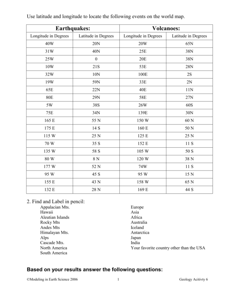
Use latitude and longitude to locate the following events on the world map. Earthquakes: Volcanoes: Longitude in Degrees Latitude in Degrees Longitude in Degrees Latitude in Degrees 40W 20N 20W 65N 31W 40N 25E 38N 25W 0 20E 38N 10W 21S 53E 28N 32W 10N 100E 2S 19W 59N 33E 2N 65E 22N 40E 11N 80E 29N 58E 27N 5W 38S 26W 60S 75E 34N 139E 30N 165 E 55 N 150 W 60 N 175 E 14 S 160 E 50 N 115 W 25 N 125 E 25 N 70 W 35 S 152 E 11 S 135 W 58 S 105 W 50 S 80 W 8N 120 W 38 N 177 W 52 N 74W 11 S 95 W 45 S 95 W 15 N 155 E 43 N 158 W 65 N 132 E 28 N 169 E 44 S 2. Find and Label in pencil: Appalacian Mts. Hawaii Aleutian Islands Rocky Mts Andes Mts Himalayan Mts. Alps Cascade Mts. North America South America Europe Asia Africa Australia Iceland Antarctica Japan India Your favorite country other than the USA Based on your results answer the following questions: ©Modeling in Earth Science 2006 1 Geology Acitivty 6 1. What kind of pattern do you see in the event locations? Hint: Can you connect the dots? 2. Does the pattern in the event locations relate to any other observable pattern on the shaded relief map? What features are found near the event locations? 3. What might be happening in the earth’s crust to explain this repeating pattern? 4. Based on your observations of the shaded relief map of the earth, do you think this kind of relationship could occur in other areas? ______. Give examples and defend your answer. 5. Now go to the program Seismic Eruption – Smithsonian Exhibit Version and run program. How do the occurrences in this program compare to your results? Based upon your observations, where do most of the world’s earthquakes and volcanoes occur? ©Modeling in Earth Science 2006 2 Geology Unit 1 WS 4 ©Modeling in Earth Science 2006 3 Geology Unit 1 WS 4
