- Urban floodplain deposits
advertisement
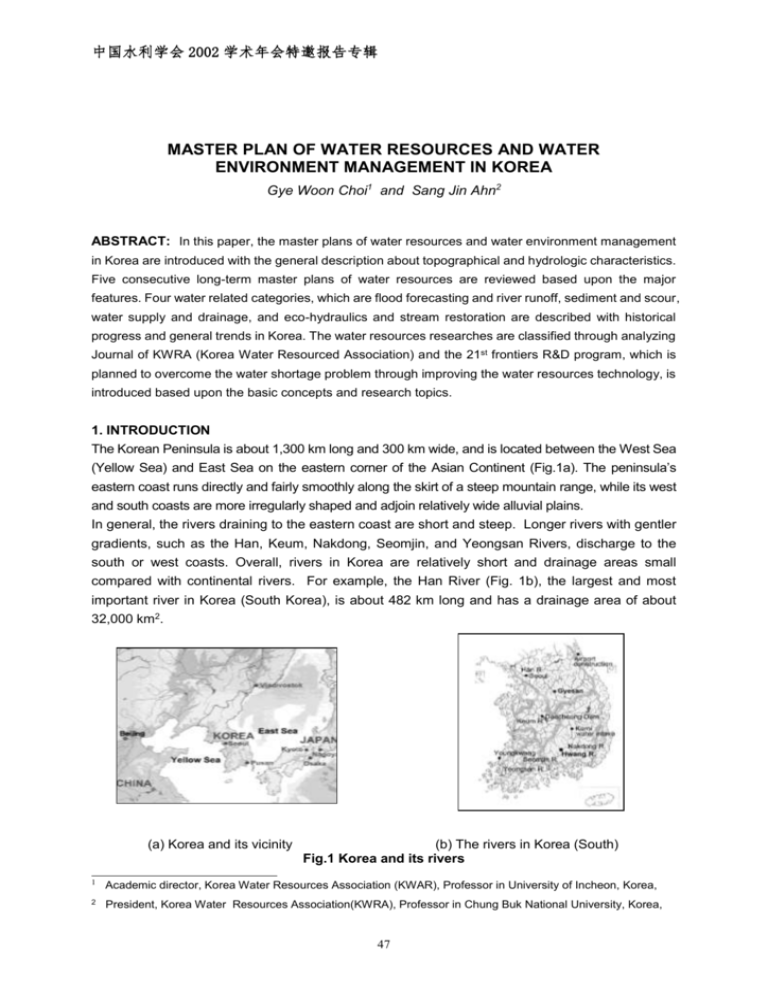
中国水利学会 2002 学术年会特邀报告专辑 MASTER PLAN OF WATER RESOURCES AND WATER ENVIRONMENT MANAGEMENT IN KOREA Gye Woon Choi1 and Sang Jin Ahn2 ABSTRACT: In this paper, the master plans of water resources and water environment management in Korea are introduced with the general description about topographical and hydrologic characteristics. Five consecutive long-term master plans of water resources are reviewed based upon the major features. Four water related categories, which are flood forecasting and river runoff, sediment and scour, water supply and drainage, and eco-hydraulics and stream restoration are described with historical progress and general trends in Korea. The water resources researches are classified through analyzing Journal of KWRA (Korea Water Resourced Association) and the 21st frontiers R&D program, which is planned to overcome the water shortage problem through improving the water resources technology, is introduced based upon the basic concepts and research topics. 1. INTRODUCTION The Korean Peninsula is about 1,300 km long and 300 km wide, and is located between the West Sea (Yellow Sea) and East Sea on the eastern corner of the Asian Continent (Fig.1a). The peninsula’s eastern coast runs directly and fairly smoothly along the skirt of a steep mountain range, while its west and south coasts are more irregularly shaped and adjoin relatively wide alluvial plains. In general, the rivers draining to the eastern coast are short and steep. Longer rivers with gentler gradients, such as the Han, Keum, Nakdong, Seomjin, and Yeongsan Rivers, discharge to the south or west coasts. Overall, rivers in Korea are relatively short and drainage areas small compared with continental rivers. For example, the Han River (Fig. 1b), the largest and most important river in Korea (South Korea), is about 482 km long and has a drainage area of about 32,000 km2. (a) Korea and its vicinity (b) The rivers in Korea (South) Fig.1 Korea and its rivers 1 Academic director, Korea Water Resources Association (KWAR), Professor in University of Incheon, Korea, 2 President, Korea Water Resources Association(KWRA), Professor in Chung Buk National University, Korea, 47 中国水利学会 2002 学术年会特邀报告专辑 The topography of the mountains along the peninsula’s orographic water divide is in a geologically mature stage, and features sharp ridges and steep valley flanks. Toward the western part of the peninsula, however, the topography is in geologically late-mature-to-old stage, and features round ridge hill masses and wide flat valley plains. The channel slopes are, therefore, relatively steep, especially in the upstream regions, because of the steep mountains and deep valleys in the uplands. Wide alluvial plains are developed at the mouths of the large rivers on the west and south coast. Consequent to these topographic features, most sediment problems occur in the western and southern parts of the peninsula, including the coastal area. The yearly distribution of precipitation is determined by westerly and northwesterly dry winds from the Asian Continent during the winter, and southeasterly wet winds from the Pacific Ocean during the summer. Because the Korean Peninsula is affected by the Monsoon, rainfall mainly occurs during summer. About two thirds of the annual precipitation of 1,283 mm occurs during the rainy season (June through September). About 15% of the annual precipitation falls during the transition period from April through May, while 20% of the precipitation falls during the remaining six months from October to next March. Fig 2. (a) illustrates the distribution of the mean annual precipitation from 1969 to 1998. 48 中国水利学会 2002 学术年会特邀报告专辑 N 속 1329 인 1119 춘 초 1272 강 강 홍 1342 대관 제 인 천 양 1360 1161 1334 령 천 이 수 제 평 1297 울 척 충 주 1193 천 원 1076 영 아 서 1307 1264 1346 1274 울 천 삼 릉 원 화 1472 천 1230 1212 청 문 주 1239 대 주 부 1201 1334 의 추풍 1357 금산 경 구 덕 1045 1162 은 1208 포 1269 군 령 주 1250 보 1272 진 영 1383 보 산 산 1392 1642 1276 서 영 성 1191 이 여 전 대 1241전 미 령 1125 977 1030 1286 부 거 산 1239 정 임 항 천 1018 합 1335 리 1300 구 1034 울 밀 산청 남 주 1302 1271 1256 1326 안 창 실 진 광 주 1363 함 승 천 1488 산 부 양 1500 원 1488 1265 통 목 여 장 주 1265 해 주 남 주 1113 평 거 1402 1249 산 1498 1411 고 1441 영 1488 울릉 제 1736 해 포 완 수 흥 1418 제 흥 1737 남 성산 도 1804 서귀 대 도 1206 1320 주 포 (a) Mean annual precipitation (mm) (b) Mean annual rainfall erosivity (MJ/ha) (MOCT, 2000) (Park et al, 2000) Fig.2 Mean annual precipitation and rainfall erosivity Due to the topographical conditions and occasional torrential rainfalls, the hydrographs of the rivers in Korea are very sharp, and peak flood discharges are very large compared with continental rivers. Ratios of maximum discharge to minimum discharge usually range from 100 up to 700. These ratios far exceed those for the rivers in Europe and United States having the coefficients is usually less than 100. The large variations in the flow create serious problems for managing Korea’s rivers. The Korean peninsular has been subject to hydrological extremes since historic times. Consequently, Koreans have developed prolonged interests in many aspects related water resources. Those interests induced fifteenth-century Koreans, for example, to invent a rain gage, which is called Chook Woo Ki. It is known as the first rain gage in the world, and is basically of the same design as the typical gage used nowadays. 49 中国水利学会 2002 学术年会特邀报告专辑 Because the flood during the rainy season is very severe and the big efforts to reduce the damage from the flood had been shown during the past several decades. However, the water shortage problem as well as the water quality during the dry season is one of the major hydraulics problems should be solved. However, the structured solutions for sever flood and droughts is must easily conducted compared to the past decades. This phenomena is occurred because the past development for water related projects is conducted without the environmentally sound consideration and the policies for water resources development may not meet people’s requirement such as the social and physical condition change. 2. WATER RESOURCES MASTER PLAN PROGRESS IN KOREA The water resources in Korea were developed based upon the long term plan master plans, which were originally prepared as the nation’s basis plan for water resources development. The first long term plan, which was called as “Water resources overall development 10 years’ plan”, was carried out in 1965 as a ten-year plan from 1966 to 1975. This plan was mainly prepared for supplying water to meet the economic development. The main projects include the multi purpose dams as well as the flood control, drought management and energy development at 5 major river basins, which is shown in Table 1, including Han river, Nak dong river basins. Major multi-purpose dams in Korea, which were mainly started to construct, based on in this plan are shown in Table 2. Table 1 Characteristics ion 5 major basins in Korea Han Nag Dong Young San Sum Jin Geum River River River River River Iden Area (Km2) Length (Km) Runoff (billion m3/year) Rainfall (mm/year) Basin Average 32,000 23,326 9,810 4,897 1,319 - 482 510 401 166 212 - 19.4 14.0 6.2 2.8 3.8 - 1,286 1,166 1,269 1,319 1,414 1,283 Table 2 Major multi-purpose dams in Korea Area Height Length Total Storage Dam name (Km2) (m) (m) (million m3) Constructed So yang 2,703 123 530 2,900 ’67-’73 Choong Ju 6,648 98 447 2,750 ’78-’86 An Dong 1,584 83 612 1,248 ’71-’77 Nam Kang 2,285 21 975 136 ’62-’70 Geum River Dae Cheong 4,134 72 495 1,490 ’75-’81 Seum Jin River 763 64 344 466 ’60-’65 Han River Nak Dong River Seum Jin The Second long term plan, which was called as “Water Resources long term master development plan”, was carried out in 1980 as a 20-year plan from 1981 to 2001. The plan was started with the 50 中国水利学会 2002 学术年会特邀报告专辑 connection with the second “land overall development plan in Korea” and the plan focused on protecting the people’s lives and properties from natural and/or man-made disasters. In the planning stage of this plan, the water demand was drastically increased and the water shortage with the increased water pollution in the streams and rivers was indicated. Also, the annual average damages by floods and typhoons reached 43 billion Korean won. The flood countermeasures, the wide water supply systems, preparation and revision of the water related laws and acts are the main items in this plan. Two different countermeasures, which are structural and non-structural countermeasures, are used for flood protections. The flood warning system, bank construction were the major structural countermeasures and the restriction of urban development and/or land use, flood plain usage restriction and so on were used as the non-structural countermeasures. The Korea Water Resources Corporation (KOWACO) were established based upon this plan. The third long term plan, which was called as “Water resources long-term master plan”, was carried out in 1990 as a 20-year plan from 1991 to 2011. The plan was prepared with five basic objectives such as sufficient water supply, flood disaster protection, establishment of new water related community, hydropower generation and integrated water resources management. The countermeasures for flood control were continued and the water was supplied based upon the four major watershed area. The construction of new water treatment plants, raw water protection (based upon the water pollution), instream flow preparation (based upon the water quantity) and the others were initiated in this plan. The fourth long term plan, which was called as “Water resources long-term master plan”, was carried out in 1996 as a 15-year plan from 1997 to 2011. This plan was prepared as the revision of the third long term plan to meet sustainable water resources concepts. In this plan the water demand management, the diversified water resources development, alternative water resources development and the others were included. It was indicated that the concepts to supply the water is changed from water consumers to water supply potentials. Also, drinking water treatment concepts having high quality were started based upon this plan. Table 3. Min items in 2000 long term master plan Main items ○Construction of multi-purpose dams -12 small or middle scale dams -environmentally sound dam construction Continuous water -reduction of water quality problem in the dam resources development ○Industrial water supply system -40-50 new wide-area water supplying system -water supplying rate increment (84%-95% until 2011) ○Desalination of sea water in small islands Diversification of the ○Systematic development and effective management of groundwater Water Sources -groundwater law revision for reducing improper consumption -basin plan for groundwater management ○Channel repairing rate increase (100% until 2005) Flood control and river ○Environmentally sound channel maintenance environment -Channel restoration maintenance -continuous monitoring The fifth long term plan, which was called as “Water resources long-term master plan”, was carried Area out in 2000 as a 25-year plan from 2001 to 2025. In this plan, the importance of the water 51 中国水利学会 2002 学术年会特邀报告专辑 environment was recognized. Stream and river restoration, and the efficient water treatment system are included in this plan. Table 3 shows the main items in the fifth long-term master plan. Table 3. Min items in 2000 long term master plan(continued) Main items ○Increment of existing dam capability and linking with the water supply system ○Accuracy increment of D/B hydrologic data -master plan of hydrologic data collection Effective use of water -real-time management system resources and demand ○Rehabilitation of old water supply system control -D/B and GIS application -web based information -integrated information system Area 3. FLOOD FORECASTING AND RIVER RUNOFF Since the computerized flood forecasting system in Korea was introduced in 1974 at the Han River Flood Control Center (FCC), which in known as the key role in flood forecast and control in Korea as well as the Han River. Several different types of rainfall-runoff model have been used for the various water resources management practices. The typical ones are: Kajiyama formula, and TANK model for the water resources planning and design; HEC-1, HEC-2, SSAPR, SWM, SWMM, Storage Function Method (SFM) for the flood analysis. The lumped conceptual model developed by Kimura (1961) has been used to predict the floods in the main FCCs (Be et al 2000). This model is based on the conservation of mass with relationship that storage of a conceptual reservoir is a nonlinear function of outflow. This method has an advantage that the computation procedures are relatively simple, but has a disadvantage that it can only compute the flows for a single event. Several scientists were tried to test more complicated physically-based models such as HEC-1 model and SSARR model on the Han River basin, Keum River basin and so on. They temporally concluded that those models are inadequate to use on the basin due to the complication of model parameters and lacks of hydrological and geologic data, and decided that the storage function methods for both watershed and channel routing are used (MOC, 1987). In addition, it has Fig 3.Flood Forecasting and Warning system in Korea no chance to make river flow predictions using the rainfalls predicted from atmospheric numerical models until the beginning of 21 century. 52 中国水利学会 2002 学术年会特邀报告专辑 However, the efforts to develop the model for the more accurate forecasting are given in these days. These efforts include the application of hydrodynamic models such as MARK Models as well as the development of a new model, which can be applied more suitable in the certain basin such as the Han River basin. Fig. 3 indicates the typical forecasting and warning system applied in the Han River basin. 4. SEDIMENTATION AND SCOUR During the past couple of decades, many dams have been constructed in Korea for multi-purpose projects: supply water to Korea’s rapidly increasing urban and industrial areas, flood protection, and hydropower. The largest dam in Korea constructed in recent times is Soyang Dam, which in located in the Han River. Its total storage capacity is about 2.9billion m3. By intercepting dams including Soyang Dam have caused riverbed degradation along downstream reaches of rivers. Extreme floods usually result in the riverbed elevation changes in large scale. When they occur with the tidal current in the river mouth, changes in the riverbed elevation are of a great scale with mostly riverbed aggradation. The typical aggradations is shown in the Han River which is the most important one in Korea in terms of the water supply source, flood control and river environment. It flows across the metropolitan Seoul in its downstream reach and merges with the Imjin River before it finally merges into the West Sea in the west of the Korean Peninsula. There is a submerged weir, across the Han River, just downstream Haengju Bridge, a boundary between Seoul and a local province. During the last decade, the riverbed in the far downstream of the Han River, has been dramatically changed to the extents of up to a 10m deposition. These changes only occurred less than in ten years. Bed sediment is composed mostly of fine sand and silt, which can be easily suspended with a small current such as tides. Some possible causes for this dramatic aggradation and degradation of the riverbed can be considered. They are 1) an extraordinary amount of sediment inflow from the upstream reach during the last decade; 2) diurnal tidal currents with fine sediment suspension; 3) an extraordinary sediment inflow from the Imjin River accumulated in the confluence of the two rivers and caused an abundant sediment source to be transported and deposited in the Han River reach; and 4) some combinations of the above possibilities. At present, KICT (Korean Institute of Construction Technology) are conducting a research project, with a field measurement and 2-D flow and sediment models, in order to find causes and practical measures to alleviate the riverbed elevation change in the reach. During the last several decades in Korea, more than 100 bridges, mostly small ones, have collapsed or been badly damaged by scour. All of the bridge-scour cases that occurred during the last several decades are related to undermining of spread footings and abutments, which are common for small bridges in Korea. Scour-related research in Korea is quite young, most of it having been performed only in the last decade. The research has entailed experimental study of the scour mechanisms (Seo et al., 1998; Choi et al., 1998), scour protection methods (Lee et al., 1995, Yoon et al., 1995), and field investigation. Many municipalities in Korea withdraw drinking water from rivers, some of which have unstable channels and sandbars. According to one study (Woo et al., 1997), 38% of 84 water intakes investigated have a significant sediment problem. Sediment deposition around the water intakes in 53 中国水利学会 2002 学术年会特邀报告专辑 the alluvial channels occurs for various reasons. The most common causes are changes in the thalweg alignment, rather than a change in the entire channel section. Since the last two decades, as significant socio-economic development progressed in Korea, many golf courses and ski slopes have been constructed on mountains and hills. Those developments have changed the local geomorphology and removed existing vegetation from watersheds. During the wet and flood season, large amounts of topsoil have been eroded and transported to the agricultural and residential areas in the lower-lying downstream areas. In 1990 for instance, a debris flow originating from a construction site for golf courses in Yongin, south of Seoul, brought a great damage to downstream areas. To prevent or reduce damages attributable to local floods and accelerated soil erosion at construction sites, requirements for Natural Disaster Impact Assessment analyses were enacted in 1996 under Korea’s revised Natural Disaster Reduction Act. The primary purposes of assessment analyses are to estimate, in advance, the effect of proposed developments on the flood, soil erosion and sediment-control capability of a development area, and ultimately to mitigate potential damage incurred by the development. In Korea, large-scale erosion and sedimentation problems are not common due to relatively favorable geologic, topographic and vegetative conditions. Nevertheless, problems of erosion and sedimentation do occur locally. They include localized incidents of bridge scour, sediment deposition on urbanized floodplains, sedimentation around municipal water intakes in alluvial channels, sediment problems at nuclear-power plants, accelerated watershed erosion at construction sites, and riverbed changes resulting from dams or gravel mining. A single most important issue of sedimentation problem in Korea would be that of riverbed aggradation and degradation, that occurs either locally or wholly in the alluvial rivers. Engineers concerned with river engineering in Korea place great emphasis on the need for more reliable methods for predicting sediment transport and local scour. Most formulas presently in use seem to lack reliability and consistency. Without doubt, they need extensive calibration to local conditions. The most important single issue concerning sediment in Korea is variation in alluvial-riverbed elevation. Channel alignment usually is not easily changed because the banks of many reaches of rivers and streams in Korea are fortified with concrete-covered levees. Yet, riverbed changes still cause numerous problems, such as for flood control, navigation, and the performance of various hydraulic structures. Additionally, a topic of growing interest in Korea is “close-to-nature” stream restoration works. In this regard, considerable effort is going into investigating the hydraulics requirements for aquatic habitat. For example, considerable attention is being given to the use of low-flow revetments formed from “eco-materials,” such as live willows and reeds. In designing such systems, it is important to predict how local changes in sediment conditions will affect riverbed and banks locally. Dam construction causes changes in river regime in the downstream reach. One of the visible changes in the downstream is an expansion of vegetation area and corresponding change in the river morphology. They are dramatically shown when the flow regime is completely changed in the sandy river reach. 54 中国水利学会 2002 学术年会特邀报告专辑 5. ECO-HYDRAULICS AND STREAM RESTORATION The first 5-year economic development plan was conducted during 1962-1966 and several different phases of the economic development plans were continued until recent years. The urbanization and industrialization in the urban area were accelerated in these periods. Consequently, the runoff in the streams and rivers is drastically increased during flood season and the runoff during the dry season is continuously reduced because of the reduced groundwater recharge and interception by drainage systems. Because the streams are mainly managed for the purpose of the flood control without the serious consideration about the flow characteristics during these periods, many streams in the urban area were changed from meandering and braided channels to straight channels. Also, the channel banks are covered with concrete blocks and/or concrete products, and the streams near the urban area were used for the purposes of car parking, recreation, and the other activities. Many streams were covered with concrete and utilized as the road for car transportation. Recently, the importance about the natural stream is recognizing and the stream restoration projects are actively being conducted. Also, several hydraulic engineers and the other specialists in the other divisions initiated the researches related to stream restoration and water quality improvement. Yang Jae Chon, Suwon Chon, Shin Chon, Osan Chon, An Yang Chon, Mu Sim Chon and so on are the typical examples of stream restoration. However, because the restoration works in some streams were conducted without serious discussions and deep researches, the other artificial landscape concepts instead of the natural stream are adopted. Therefore, the more deep insight and researches are necessary for the stream restoration and water quality improvement as well as increment of the water quantity in the stream. Fig. 4, which is obtained in the case of Yang Jae Chun near Seoul City, indicates the feature of the typical stream restoration. (a) before stream restoration (b) after stream restoration Fig.4 The Example of the stream restoration in Yang Jae Chon 6. WATER SUPPLY AND DRAINAGE The total capacity of water treatment plant in Korea indicates 27 million m3/day with the supply service of 87% among total population, about 48 million people. The municipal wastewater treatment capacity of 17.3 million m3/day as shown in Table 4 is distributed in the whole country. Most municipal wastewater plants were constructed with the capacity over 50,000 m 3/day located in the vicinity of downstream in the streams. 55 中国水利学会 2002 学术年会特邀报告专辑 Table 4. The total capacity of municipal wastewater plants in Korea Classification Over 50,000 10,000~50,000m3/day Below 10,000 3 m /day m3/day Capacity 16,113,600 1,037,000 181,945 (Unit:m3/day) Total 17,332,545 The enhanced plant operation and the increment of the removal efficiencies of organic materials, nitrogen and phosphorus are the most concerning topics to the waste water the related researchers and engineers. At the end of 2000, the total length of the water supply network in Korea is 117,949km and about 50% of the total length was installed after 1991. Three different pipes, which are the iron pipe, cast iron pipe and plastic pipe, occupy most of the distribution pipe network. The main concerns to the researchers and engineers in the water supply network are the flow simulation, and leak detection and maintenance. Two different municipal wastewater systems, which are combined sewer system and the separate sewer system, are used in Korea. The combining sewer system is about 64% of the total sewer system. Table 5. indicates the variation of the total length of the sewer system. Table 5. The variation of the total length of the sewer system Unit : Km Classification ‘92 ‘93 ‘94 ‘95 ‘96 ‘97 ‘98 Combined Sewer 32,153 33,259 34,144 35,760 36,591 38,148 40,160 Separate Sewer 13,958 15,466 16,735 17,024 19,239 20,523 22,170 Total 46,111 48,725 50,879 52,784 55,830 58,671 62,330 The water quality improvement and wastewater leakage in the sewer system attract the attentions from the researchers and engineers in these fields. 7. WATER RESOURCE RELATED RESEARCH IN KOREA The researches conducted in the field in water resources including hydraulics, hydrology, water resources planning and management, water supply and drainage and coastal engineering are Table 6. Papers published in Journal of KWRA during 1968-2002 Classification Experimental Analysis Theoretical and Statistical Analysis Numerical Analysis Total Rainfall Analysis 14 56 43 113 Overland Runoff 6 58 24 88 Flood forecasting and River Runoff 27 78 93 198 Scour and Sedimentation 29 16 20 65 Reservoir Operation and Management 20 38 16 74 Water supply and Drainage 8 16 13 37 Water treatment and System Operation 11 13 4 28 Water Quality 9 24 14 47 Groundwater 9 14 12 35 Coastal Engineering 13 21 17 51 Eco-hydraulics and Stream Restoration 2 3 3 8 Others 18 15 15 48 Total 166 352 274 792 56 中国水利学会 2002 学术年会特邀报告专辑 analyzed through reviewing Journal of Korea Water Resources Association(KWRA). KWRA is an association having about 2,000 members working in the water related areas and focuses on a better understanding of water flow phenomena, technical improvement using information tools and models as well as engineering applications. The papers published in Journal of KWRA are classified in Table 6. As shown in Table 6, flood forecasting and river runoff simulation are the major research topics in the field of hydraulics in Korea. About twenty five percent of the total papers published in Journal of KWRA are related with the flood forecasting and river runoff simulation. Sedimentation and Scour are the second major topics in the field of hydraulics and is about 8 percent of the total papers. Flow simulation in water supply and drainage systems are also indicated as the matter of interest in the field of hydraulics. Recently, the concerns on eco-hydraulics including water quality is greatly increased. Table 7 indicates the comparison of the papers published in Journal of KWRA in the periods of 1968-1990, 1990-1999 and 2000-2002. Table 7. The comparison of research patterns during 1968-2002 Classification 1968 - 1990 1990 - 1999 2000 - 2002 Total Rainfall Analysis 34 54 25 113 Overland Runoff 14 56 18 88 57 108 34 199 12 37 15 64 12 51 11 74 Water supply and Drainage 6 27 4 37 Water treatment and System Operation 3 20 5 28 Water Quality 10 21 16 47 Groundwater 6 25 4 35 Coastal Engineering 23 20 8 51 1 3 4 8 2 34 12 48 180 456 156 792 Flood forecasting Runoff and River Scour and Sedimentation Reservoir Operation Management Eco-hydraulics Restoration and and Stream Others Total As Shown in Table 7, the research papers are drastically increased in recent years. Flood forecasting and river runoff simulation, scour and sedimentation are the topics of constant concerns in the hydraulics area in Korea. Recently, the concern of eco-hydraulics and stream restoration, and water quality are greatly increased. Water shortage problem through improving the water resources technologies. The total amount of 100 billion Korean won (about 83million dollar) is expected to allocate by Korean government during 10 years. The research will be conducted with three different phases, which are shown in Table 8. 57 中国水利学会 2002 学术年会特邀报告专辑 Twenty-two different research topics as shown in Table 9. were selected in the four different major research fields of integrated management of water resources, surface water, groundwater and alternative water resources. Korean government also allows some additional researches, which can be widely applied with the technologies developed by above topics. The Fig. 5 indicates the schematic diagram of the research purposes and main technologies, which is expected to be developed in each division. Table 8. Three difference phases of Frontier R&D Program Phase Year Main Objectives 1st phase 2001-2004 (3years) to develop the basic elements and the basis of the technology in the water resource field. 2nd phase 2004-2007 (3years) to utilize and systemize the developed technologies from the first phase. 3rd phase 2007-2011 (4years) to integrate every system by using the developed and utilized technologies from the first and second phases and contribute to secure water resources by making it common usage. Intergrated management Analysis Preservation Allocation Measurment Conservation Operation Simulation Evaluation Intergrated management of water resources Surface water technology Ground water technology Alternater Water resources technology Fig 5. The Schematic diagram of research development for frontier R&D Program. Field Table 9. Research topics in Frontier R&D program Topics Technology for Integrated Water Resources Management Technology for Hydrologic Data Acquisition and Monitoring Integrated Management of Water Resources Technology for Effective Use of Temporal and Spatial Data in a River Basin Water Resources Application of Short- and Long-Term Weather Forecast System Water Resources Policy for Sustainable Water Resource Development Technology for Integrated Basin-wide Water Budget Analysis and Water Resources Planning Development of Real-time Water Resources Management System 58 中国水利学会 2002 学术年会特邀报告专辑 Technology for Surface water Resources Investigation Analysis and Modeling for Surface water Hydrological Components Surface Water Analysis and Modeling of River Flow and Bed Changes Technology for Sustainable Dam Development Technology for Sustainable River Flow Development Technology for Site Characterization, Assessment and Exploration Method of Groundwater Resources Groundwater Flow Analysis and Modeling Ground Water Assessment of Groundwater Res. Availability Based on Topographic and Geologic Cha Technology for Sustainable Groundwater Development and Artificial Recharge Technology for Pollution Prevention, Protection and Remediation of Groundwater Resources Development of Water Reuse Technology Technology for Leakage Control in Water Distribution and Supply System Alternative Water Resources Technology for Rainwater Storage and Utilization Technology for Highly-Efficient and Energy-saving Desalination System Application for Wastewater Reclamation and Reuse 8. SUMMARY The master plans of water resources and water environment management in Korea are introduced with the general description about topographical and hydrologic characteristics and the following summaries can be obtained. First, Five consecutive long-term master plans (1965-2000) of water resources are reviewed. In this paper, the major features in each long-term master plan are described. Second, four water related categories in Korea, which are flood, forecasting and river runoff, sediment and scour, water supply and drainage, and eco-hydraulics and stream restoration are described about historical progress and general trends. Third, the water resources researches are analyzed through the Journal of KWRA(Korea Water Resourced Association). Also, the 21st frontiers R&D program, which was planned to overcome the water shortage problem through improving the water resources technology, is introduced based upon the basic concepts and research topics. REFERENCES [1] Choi, G. W., Woo, H. S., 2002, “Hydraulic Characteristics and Research Advance in Korea”, First Annual conference between CSU faculty and Korea Alumni, Colorado State University, Fort Collins, Co. [2 ]Choi, G. W., Ham, C. H., Jun, B. H. and Ahn, S. J. 1998. "Influence of the local scour by interaction between bridge piers." Proceedings of 3rd International Conference on Hydro-Science and-Engineering, Cottbus, Berlin, Germany. [3] Deg-Hyo Bae, Jun-Seok Chung, and Won-Tae Kwon, “A preliminary study for the coupled atmosphere-streamflow modeling in Korea.” International Journal of KWRA. [4] Kim, Sung, “Introduction of Sustainable water Resources Research Commit“, 21st Frontiers R&D Program. 59 中国水利学会 2002 学术年会特邀报告专辑 MOCT. 2000. The Long-Term Master Plan of Water Resources. Ministry of Construction, Republic of Korea. [5] Seo, J. P., Yoon, B. and Yeo, W. K. 1998. "Investigation of scour characteristics around pile group with varing pile spacing." Proceedings of 1998 Annual Conference, Korean Society of Civil Engineers. (in Korean) Water Resources Operations Center, Korea Water Resources Corporation. [6] Wischmeier, W. H. and Smith, D. D. 1960. "A universal soil-loss equation to guide conservation farm planning." 7th International Congress of Soil Science, Madison, Wisc. [7] Yoon, Y. N. and Lee, J. S. 1998. "Estimation of scour depth at bridges and comparative analysis between estimated and measured scour depth." Proceedings of 3rd International Conference on Hydro-Science and Engineering, Cottbus, Berlin, Germany. 60
