First Draft Analysis Framework
advertisement
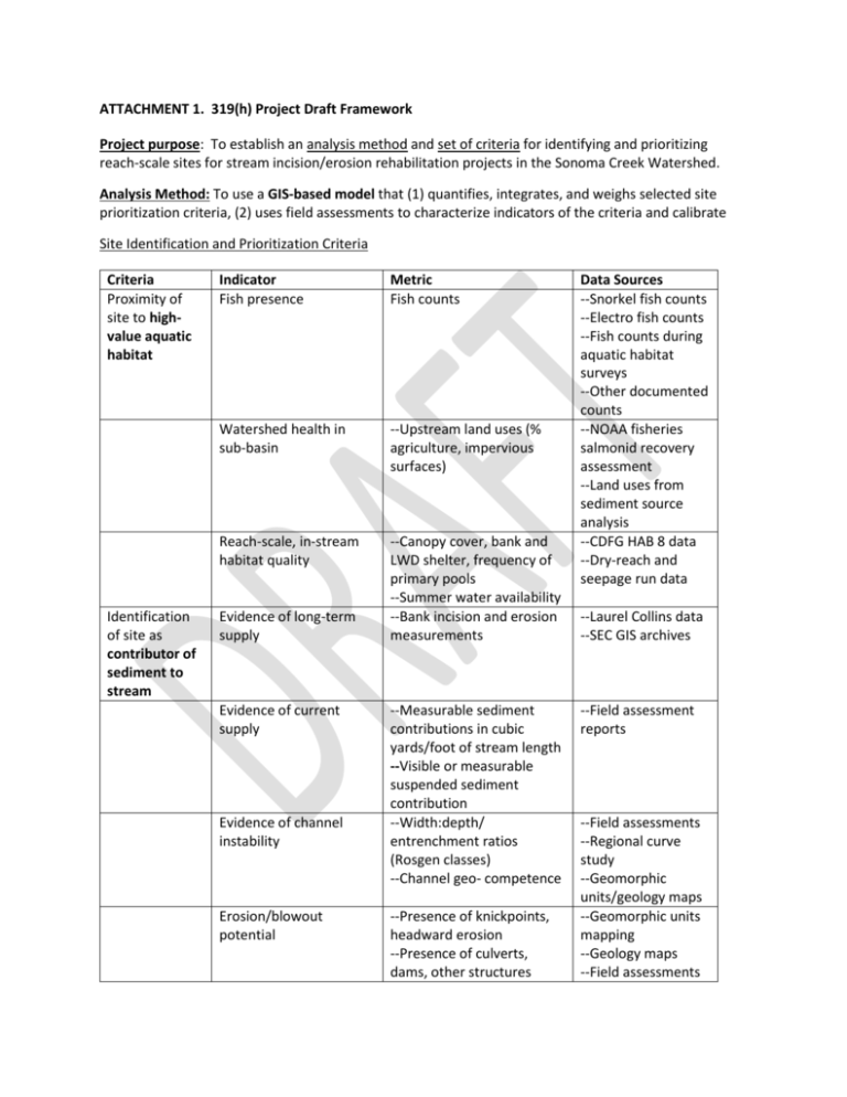
ATTACHMENT 1. 319(h) Project Draft Framework Project purpose: To establish an analysis method and set of criteria for identifying and prioritizing reach-scale sites for stream incision/erosion rehabilitation projects in the Sonoma Creek Watershed. Analysis Method: To use a GIS-based model that (1) quantifies, integrates, and weighs selected site prioritization criteria, (2) uses field assessments to characterize indicators of the criteria and calibrate Site Identification and Prioritization Criteria Criteria Proximity of site to highvalue aquatic habitat Identification of site as contributor of sediment to stream Indicator Fish presence Metric Fish counts Watershed health in sub-basin --Upstream land uses (% agriculture, impervious surfaces) Reach-scale, in-stream habitat quality --Canopy cover, bank and LWD shelter, frequency of primary pools --Summer water availability --Bank incision and erosion measurements Evidence of long-term supply Evidence of current supply Evidence of channel instability Erosion/blowout potential --Measurable sediment contributions in cubic yards/foot of stream length --Visible or measurable suspended sediment contribution --Width:depth/ entrenchment ratios (Rosgen classes) --Channel geo- competence --Presence of knickpoints, headward erosion --Presence of culverts, dams, other structures Data Sources --Snorkel fish counts --Electro fish counts --Fish counts during aquatic habitat surveys --Other documented counts --NOAA fisheries salmonid recovery assessment --Land uses from sediment source analysis --CDFG HAB 8 data --Dry-reach and seepage run data --Laurel Collins data --SEC GIS archives --Field assessment reports --Field assessments --Regional curve study --Geomorphic units/geology maps --Geomorphic units mapping --Geology maps --Field assessments Physical evidence of instream impacts Restoration feasibility of site issues Landowner willingness Ease of access Solution availability Cost of potential actions --Presence of erodible bedrock, fine sediment in bed and banks, lack of protective vegetation --Embeddedness, pool filling, gravel impermeability --Suspended sediment in water column --Impacted benthic macroinvertebrates, other aquatic species --Working partnership in place --Stream Stewards group active --Signed landowner agreements --Access agreements in place --MOU in place for access on public lands --Percent success of comparable remediation strategies in and beyond watershed (e.g., alluvial fan restoration, bank revegetation, landslide detention) --Limiting factors analysis --Sediment source analysis --Ongoing monitoring --Landowner database of signed agreements --Landowner database of signed agreements --Project dossiers --US EPA/TMDL success stories --SEC/partner success stories --Cost estimate for specific --Final project in place project/planning --Cost estimate available reports from comparable projects Reference: A transferable protocol to identify and prioritize sites for watershed restoration under Clean Water Act Programs, SEC and Watershed Sciences, 2010 (http://knowledge.sonomacreek.net/TMDL_Planning)

