Weathering & Erosion Key
advertisement
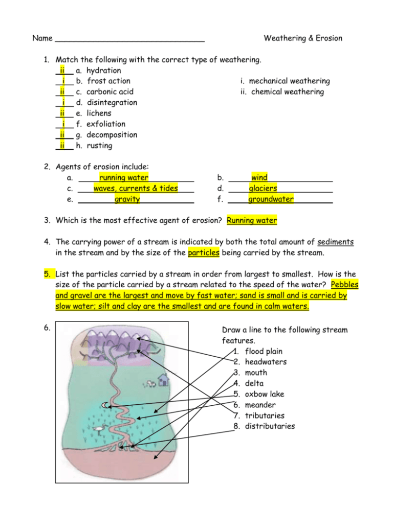
Name _______________________________ Weathering & Erosion 1. Match the following with the correct type of weathering. ii a. hydration i b. frost action i. mechanical weathering ii c. carbonic acid ii. chemical weathering i d. disintegration ii e. lichens i f. exfoliation ii g. decomposition ii h. rusting 2. Agents of erosion include: a. running water c. waves, currents & tides e. gravity b. d. f. wind glaciers groundwater . 3. Which is the most effective agent of erosion? Running water 4. The carrying power of a stream is indicated by both the total amount of sediments in the stream and by the size of the particles being carried by the stream. 5. List the particles carried by a stream in order from largest to smallest. How is the size of the particle carried by a stream related to the speed of the water? Pebbles and gravel are the largest and move by fast water; sand is small and is carried by slow water; silt and clay are the smallest and are found in calm waters. 6. Draw a line to the following stream features. 1. flood plain 2. headwaters 3. mouth 4. delta 5. oxbow lake 6. meander 7. tributaries 8. distributaries 1 7. T/F. The water on the inside of a meander moves faster than the water on the outside of a meander. 8. T/F. Water moves the fastest at the mouth of a stream. 9. T/F. An oxbow lake is formed from a meander. 10. T/F. Deposition occurs on the outside of a meander. 11. T/F. A well-developed flood plain will most likely be wide with lots of meanders. *********** 12. Where is wind erosion most effective? In arid or dry regions 13. Define or draw a picture of the following terms associated with wind erosion/deposition. a. abrasion: wearing away of rock by grinding action b. deflation: removal of loose rock particles by the wind c. ventifacts: wedge-shaped rock formed by wind coming from 1 direction d. toadstools: mushroom rock formed by wind coming from all directions e. dunes: hills of sand deposited by wind at a windbreak f. loess: fine, unlayered, angular silt-size particles deposited by wind ********** 14. Identify the following types of mass movement: a. creep: slow imperceptible downward movement of soil - noticed by fence posts and poles leaning downhill. b. landslides: sudden movement of bedrock/loose rock down a steep slope c. avalanches: landslide with snow, ice, soil and mixture of rocks d. mudflows: rapid movement of water saturated mass of clay & silt e. slumps: small blocks of land tilt and move downhill ********** 15. Glaciers are born in areas always covered by snow. 2 Name _______________________________ Weathering & Erosion 16. Look at the diagram on p 193 of your text. What relationship does the graph show? It shows the relationship between the elevation of the snow line and latitude. 17. Still referring to the diagram on p 193, how tall would a mountain have to be to form a glacier if you lived in Puerto Vallarta, Mexico (20oN). about 4000 m. 18. List features of glacial topography. a. moraines b. tarns/cirque lakes d. eskers e. drumlins g. horns h. hanging trough c. f. i. eskers arête striations 19. How are crevasses formed? Giant cracks form in the top of a valley glacier when it moves down steep slopes. The glacier top is brittle, the bottom is flexible. 20. How are icebergs formed? What is the scientific term for this? (MOOOOOOOO!)? Glaciers that meet the sea have great blocks of the glacier break off to form icebergs. This is known as calving. 21. Explain the difference between glacial till and glacial outwash. Till is unsorted, unstratified rocks deposited directly by the glacier. Outwash is sorted, stratified rocks deposited by glacial meltwater. 22. What are the different types of glacial moraines and where are they found? a. ground: material carried in the bottom of the glacier b. medial: 2 glaciers become one: it is the moraine found in the middle formed from 2 former lateral moraines c. lateral: found along the edges/sides of a glacier d. end/terminal: moraine that marks a glacier’s farthest advance ********** 23. What is karst topography? generally a limestone region that has been eroded by groundwater 24. What are some features of karst topography? Sinkholes, lost rivers, caves, disappearing streams 25. The scientific study of caves is speleology. 3 26. Distinguish among the following groundwater depositional features: a. stalagmites – rounded masses on a cave floor formed from calcite deposits b. stalactites – icicles formed in caves from calcite deposits c. pillars – stalactites & stalagmites meet d. dripstone (when is the only time this feature forms?) calcite deposit formed from dripping water in caves – formed only when cave is above the water table e. travertine – calcite deposits around mineral springs f. geyserite – silica dissolved around geysers g. petrified wood – minerals dissolved in groundwater replace decaying wood of buried trees 4
