Typhoon Fung-wong Disaster Response Reports — 1st Report
advertisement
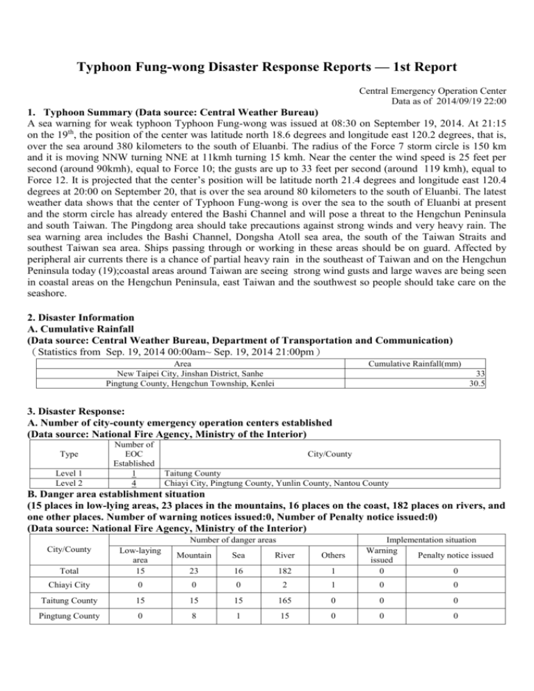
Typhoon Fung-wong Disaster Response Reports — 1st Report Central Emergency Operation Center Data as of 2014/09/19 22:00 1. Typhoon Summary (Data source: Central Weather Bureau) A sea warning for weak typhoon Typhoon Fung-wong was issued at 08:30 on September 19, 2014. At 21:15 on the 19th, the position of the center was latitude north 18.6 degrees and longitude east 120.2 degrees, that is, over the sea around 380 kilometers to the south of Eluanbi. The radius of the Force 7 storm circle is 150 km and it is moving NNW turning NNE at 11kmh turning 15 kmh. Near the center the wind speed is 25 feet per second (around 90kmh), equal to Force 10; the gusts are up to 33 feet per second (around 119 kmh), equal to Force 12. It is projected that the center’s position will be latitude north 21.4 degrees and longitude east 120.4 degrees at 20:00 on September 20, that is over the sea around 80 kilometers to the south of Eluanbi. The latest weather data shows that the center of Typhoon Fung-wong is over the sea to the south of Eluanbi at present and the storm circle has already entered the Bashi Channel and will pose a threat to the Hengchun Peninsula and south Taiwan. The Pingdong area should take precautions against strong winds and very heavy rain. The sea warning area includes the Bashi Channel, Dongsha Atoll sea area, the south of the Taiwan Straits and southest Taiwan sea area. Ships passing through or working in these areas should be on guard. Affected by peripheral air currents there is a chance of partial heavy rain in the southeast of Taiwan and on the Hengchun Peninsula today (19);coastal areas around Taiwan are seeing strong wind gusts and large waves are being seen in coastal areas on the Hengchun Peninsula, east Taiwan and the southwest so people should take care on the seashore. 2. Disaster Information A. Cumulative Rainfall (Data source: Central Weather Bureau, Department of Transportation and Communication) (Statistics from Sep. 19, 2014 00:00am~ Sep. 19, 2014 21:00pm) Area New Taipei City, Jinshan District, Sanhe Pingtung County, Hengchun Township, Kenlei Cumulative Rainfall(mm) 33 30.5 3. Disaster Response: A. Number of city-county emergency operation centers established (Data source: National Fire Agency, Ministry of the Interior) Type Level 1 Level 2 Number of EOC Established 1 4 City/County Taitung County Chiayi City, Pingtung County, Yunlin County, Nantou County B. Danger area establishment situation (15 places in low-lying areas, 23 places in the mountains, 16 places on the coast, 182 places on rivers, and one other places. Number of warning notices issued:0, Number of Penalty notice issued:0) (Data source: National Fire Agency, Ministry of the Interior) Number of danger areas City/County Implementation situation Warning Penalty notice issued issued 0 0 Total Low-laying area 15 Chiayi City 0 0 0 2 1 0 0 Taitung County 15 15 15 165 0 0 0 Pingtung County 0 8 1 15 0 0 0 Mountain Sea River Others 23 16 182 1 C. Mountain climber contact (Data Source: National Police Agency, Ministry of the Interior) Date table made: Sep. 19, 2014 The Action for People Already Enter the Mountains Have not Yet Safe Contacted and Already accommodation in Sheltering on the Now descending Been Contacted descended mountains Spot Case Person Case Person Case Person Case Person Case Person Case Person Case Person 153 895 111 675 42 220 0 0 0 0 0 0 0 0 Applied For Persuaded to not Entering Enter Mountain Mountain Areas Areas (Note: People who have not been contacted means the climbers have not contacted with rangers, family members, or police departments for more than 48 hours after entering mountain areas. This statistical data is filled in and reported by National Police Agency, Ministry of the Interior after collecting and arranging Ministry of Education, and Construction and Planning Agency Ministry of the Interior statistical data.) D. Ensconced Fishermen from Mainland China (Data source: Council of Agriculture of Executive Yuan) Time 2014/09/19 20:47 Ensconced on Boats Ensconced in Coastal Shelters 892 196 Total 1088 4. Evacuation and Shelter Status A. Evacuated people (Data Source: Department of Civil Affairs, Ministry of Interior) No evacuated areas at present B. Shelter situation Shelter (Data Source: Ministry of Health and Welfare) No shelters established at present 5.Disaster statistics A. Death and injury (Data source: National Fire Agency, MOI) No deaths or injuries B. Transport situation ( Data source: Ministry of Transportation and Communications) Road, railway and air transport operating normally at present. 6. City and County Emergency Operations Support situation Military personnel deployed in high risk areas in advance (Data source: Ministry of National Defense) The military has deployed 42,915 servicemen and 3,139 vehicles of 39 types in advance in high risk areas. Area Table of Military Disaster Response Forces in Each Combat Area 3rd Combat Area 5th Combat Area 4th Combat Area 2nd Combat Area (North) (Center) (South) (East) North Region Central Region East Region Location Number of forward 14,418 Persons personnel Number of 1,277 vehicles of 10 vehicles in place types Total 9,821 Persons 12,408 Persons 6,268 Persons 4,2915 Persons 750 vehicles of 9 types 747 vehicles of 11 types 365 vehicles of 9 types 3,139 vehicles of 39 types
