WorldView Software: World Geography Climate Map of Latin
advertisement
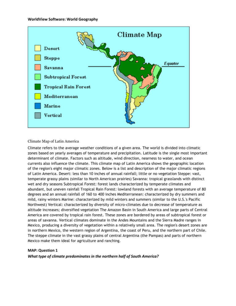
WorldView Software: World Geography Climate Map of Latin America Climate refers to the average weather conditions of a given area. The world is divided into climatic zones based on yearly averages of temperature and precipitation. Latitude is the single most important determinant of climate. Factors such as altitude, wind direction, nearness to water, and ocean currents also influence the climate. This climate map of Latin America shows the geographic location of the region's eight major climatic zones. Below is a list and description of the major climatic regions of Latin America. Desert: less than 10 inches of annual rainfall; little or no vegetation Steppe: vast, temperate grassy plains (similar to North American prairies) Savanna: tropical grasslands with distinct wet and dry seasons Subtropical Forest: forest lands characterized by temperate climates and abundant, but uneven rainfall Tropical Rain Forest: lowland forests with an average temperature of 80 degrees and an annual rainfall of 160 to 400 inches Mediterranean: characterized by dry summers and mild, rainy winters Marine: characterized by mild winters and summers (similar to the U.S.'s Pacific Northwest) Vertical: characterized by diversity of micro-climates due to decrease of temperature as altitude increases; diversified vegetation The Amazon Basin in South America and large parts of Central America are covered by tropical rain forest. These zones are bordered by areas of subtropical forest or areas of savanna. Vertical climates dominate in the Andes Mountains and the Sierra Madre ranges in Mexico, producing a diversity of vegetation within a relatively small area. The region's desert zones are in northern Mexico, the western region of Argentina, the coast of Peru, and the northern part of Chile. The steppe climate in the vast grassy plains of central Argentina (the Pampas) and parts of northern Mexico make them ideal for agriculture and ranching. MAP: Question 1 What type of climate predominates in the northern half of South America? Question 2 Given the information on this map, where would you suppose Mexico's Sierra Madre Mountains are located? Question 3 How have climate and geography worked together to affect human settlement patterns in Latin America?


