Big Local SW11 Profile of Battersea
advertisement
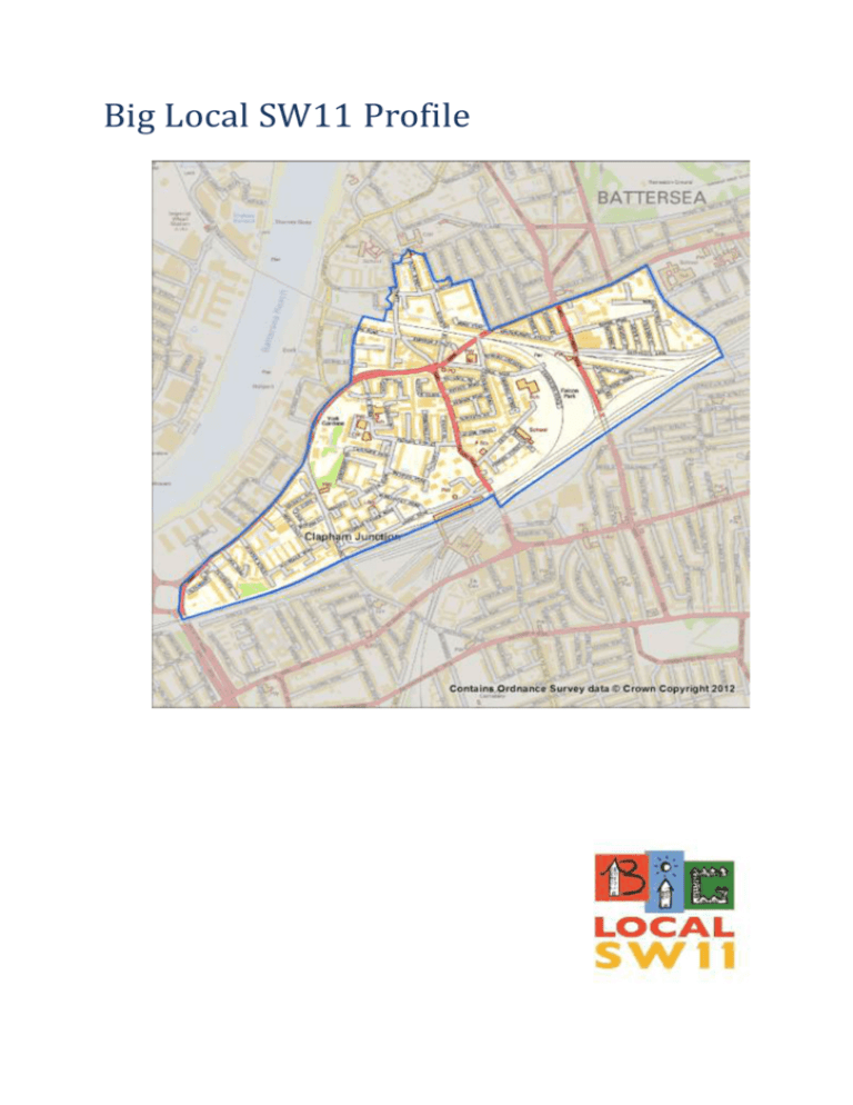
Big Local SW11 Profile Contents Introduction - Location Brief history What people think Achieving & Potential - Work Education Jobs Safety & well-being - Crime in the area Housing Local services Influence, advocacy & ownership - Local politics Local business Community, Relationships & Belonging - People Sources Introduction This document intends to give an flavour of the Big Local SW11 area, it is not a conclusive summary of everything happening in the area but by reading this it is hoped that an understanding of the context that Big Local SW11 are working in is made clearer. Location “Well-connected” The Big Local SW11 area like a lot of areas in central London is a diverse mix of various micro communities, based on ethnicity, religion and culture. The area consists of a group of contiguous council estates lying to the north of Clapham Junction station, new build flats and terraced streets. The area has a lot to offer, being very close to the River Thames, nearly adjoining Battersea Park, a mile down the road from Battersea power station redevelopment and just over 3 miles from parliament. Clapham Junction Station is part of the area and one of the busiest railway stations in Europe. The majority of the Big Local area falls within the Latchmere ward which exhibits significant disadvantage across most dimensions of deprivation. This is one of the borough’s priority neighbourhoods and is subject to continued specific and targeted action to reduce these inequalities. Brief history of the area “Industry, railways and asparagus” Big Local SW11 is located in Battersea, originally Battersea was an old island village settlement, as with many former Thames island settlements, Battersea was reclaimed by draining marshland and building culverts for streams. Before the Industrial Revolution, much of the area was farmland, providing food for the City of London and surrounding population centres; and with particular specialisms, such as growing lavender on Lavender Hill, asparagus (sold as "Battersea Bundles") or pig breeding on Pig Hill. Industry developed eastwards along the bank of the Thames during the industrial revolution from 1750s onwards. An 1874 map of the area shows the following factories, running along the Big Local area producing starch, silk, malt, corn, candles, chemical works, saltpetre works, and foundries. In 1929, construction started on Battersea Power Station, being completed in 1939. From the late 18th century to comparatively recent times Battersea, and certainly north Battersea, was established as an industrial area with all of the issues associated with pollution and poor housing affecting it. Battersea was radically altered by the coming of railways. An interchange station was built in 1863 towards the north west of the area, at a junction of the railway. Taking the name of a fashionable village a mile and more away, the station was named Clapham Junction. A campaign to rename the station "Battersea Junction" fizzled out as late as the early twentieth century. The railway station encouraged the local government to site its buildings - the town hall, library, police station, court and post office in the area surrounding Clapham Junction; the Arding and Hobbs department store, diagonally opposite the station, was the largest of its type at the time of its construction in 1885; and the area was served by a vast music hall - The Grand - opposite the station and nowadays serving as a nightclub and venue for smaller bands. All this building around the station marginalised Battersea High Street (the main street of the original village) into no more than an extension of Falcon Road. What people think “Strong but fragmented community” When we spoke to local residents and workers we asked them what they like about the area they said: “Community is very strong” “Great sense of community” “The amazing people living here” “I live here!” “I grew up here.” “Family orientated” “Lot of activities for kids” “It’s becoming a safer place for the community” “Events are often held to bring the community together” “It is so close to transport links – linking us to the rest of London.” “Diversity” “Shopping at Clapham Junction“ “Parks and green spaces” “Close to the river” The main pieces of feedback that fed into our vision suggest people want to see improvement in the following: - Ability to build community across barriers and get to know neighbours Opportunity to work, learn and volunteer Improvement in safety Know how to influence and shape what happens locally. Therefore Big Local SW11’s vision is: “As residents and workers in SW11, we have a long term vision of our community as a place where... Everyone has the opportunity and confidence to widen their horizons and to maximise their potential for learning, working and achieving. (Achieving & Potential) A community where everyone feels safe, that they belong. (Safety & wellbeing) Where everyone can have a voice, shape their future and influence the design of space and services in a way that develops ownership. (Influence & ownership.) We all have the opportunity to meet and interact across the wider community, to learn and belong. (Community & belonging) We’re committed to work in partnership to make this happen over the next 10 years and be sustainable for even longer.” The sections below detail the context Big Local SW11 are working in for each of the vision areas. Achieving & Potential Work “A large number of professionals but growing unemployment” Because of its location close to Clapham Junction station there are a large number of commuters with 50.9% in full time employment compared to a national average of 38.5%, 3.8% unemployed compared with a national average of 4.4%. 50% of those working are in some form of managerial position. The Wandsworth population is generally affluent. GLA estimates suggest that Wandsworth has a higher proportion of 18-29 year olds who are economically active than any other London Borough, and the proportion of income benefit claimants is low. However, significant pockets of deprivation exist within the borough. According to official labour market statistics for the calendar year 2009, 4.2% of the population aged between 16 and 24 were on income support, but the proportion in the Latchmere ward (which is most of the BLSW11 area) is more than twice as high (9.6%). Since 2008 there has been an increase in the number of Job Seeker Allowance claimants. 3874 of working age residents in the Latchmere ward were not in work at the time of 2011 census, 1270 had never worked. There are sharp variations between wards. In February 2010, 4.8% of the working age population in Latchmere were on lone parent benefits, compared to 0.6% in Northcote (neighbouring ward). The percentage of children aged 0-19 living in households claiming benefits, as at May 2008, followed a similar distribution, with 41.0% (1,315 children) in Latchmere compared to 7.2% (220) in Northcote. Education “Good but with a lot of ‘imports’ and ‘exports’” There are 4 state primary schools in the area, 2 independent schools and 1 state secondary just outside the boundary. Statistics for the 4 state primary schools: Number of pupils Number of teachers % English not first language % eligible for free school meals Ofsted rating Falconbrook 290 21 High View 309 21 Sacred Heart 445 30 Christchurch 196 11 64.7 46.8 66.5 40.4 52.5 35.7 30.6 43.8 Good Good Good Good Statement about education The population of maintained schools differs from the borough resident population due to pupils seeking education in other boroughs (“exports”) and the independent sector and a significant “import” of pupils from neighbouring boroughs, in particular Lambeth. This results in a larger Black, Asian and minority ethnic (BAME) school population than is the case in the resident population. For more than 2000 residents of the usual 14,702 residents in Latchmere English is not their main language. Safety & well-being Crime in the area “Majority anti-social behaviour” There were 1279 recorded crimes in 2012/13. A snapshot of one month’s crime showed that 62% were due to antisocial behaviour and 26% were crimes against the person. In December 2013, 49 recorded crimes were due to Anti-Social Behaviour. Crime levels did seem to be lower in 2013 than in 2012. All crime in December 2013 totalled 115 incidents compared with 146 in December 2012 and 111 in November 2013 compared with 204 in November 2012. The London Riots happened in the summer of 2012, part of them happening in Clapham Junction, which has since attracted a lot of attention and support for the area. Of the 23 violence and sexual crimes recorded in Dec 13, 19 happened on the York Road Estate in the heart of the Big Local Area. May – Dec 2013 Crime type Total Percentage Anti-social behaviour 415 32.55% Bicycle theft 47 3.69% Burglary 70 5.49% Criminal damage and arson 70 5.49% Drugs 65 5.10% Other crime 12 0.94% Other theft 86 6.75% Possession of weapons 4 0.31% Public order 50 3.92% Robbery 54 4.24% Crime type Total Percentage Shoplifting 15 1.18% Theft from the person 67 5.25% Vehicle crime 102 8.00% Violence and sexual offences 218 17.10% Housing Industry declined and moved away from the area in the 1970s, and local government sought to address chronic post-war housing problems with large scale clearances and the establishment of planned housing. More recently, some decades after the end of large scale local industry, residential overspill from fashionable Chelsea, the area to the north across the Thames, has changed the character of much of Battersea. Factories have been demolished and replaced with modern apartment buildings. Some of the council owned properties have been sold off and several traditional working men's pubs have become more fashionable bistros, although much local authority housing and industrial areas still remain. There has been considerable redevelopment over the previous decade on brownfield sites (previously industrial land) within the Borough of Wandsworth, with around 10,000 new homes built since 2001/02. There has been a huge amount of development along the river front next to the Big Local Area bringing in new commuters and young professionals. In 2009, it was announced that a new US embassy would be constructed about a mile up the road at Nine Elms. This development would also see the building of luxury apartments in the area. The largest council housing estate is the Winstanley Estate which together with the York Road, Falcon, Kambala, Badric Court and Wayland Road estates, make up a neighbourhood housing around 15,000 residents. The area also has a mix of private housing and terraced streets with an average house price of £700,000 upwards. For a 4 bed terraced house in ‘Little India’ the price is around £1.1 million. Local services “No shortage” Local Services and play areas can be broken down into three groups and defined as following: Public – e.g. community schools, play areas, healthcare service, sheltered housing Community – e.g. places of worship, community centres supported by local council funding Local Businesses – e.g. retail shops, pubs, hairdressers There are 3 doctors surgeries in the area, one post office, a fire station and Clapham Junction Railway station. There are two large open green park areas - York Gardens and Falcon Park - and a supervised adventure playground. This is in addition to separate ring-fenced but unsupervised children play areas/grounds within each estate as well as two operational club rooms run by active resident associations who provide closed but supervised play areas. There is no shortage of community services offering a wide range of activities and events - from places of worship for different dominations, youth clubs, after school services or lunch clubs. Although some of the services are delivered at no cost to the user there are some where the users are expected to make a monetary contribution i.e. subs for youth club or pay a set cost for using the service for example the leisure facilities, holiday play-schemes or some of the sheltered or retirement housing. There are two council run Leisure centres in the area plus a few private gyms/fitness shops. Falcon Road runs through the heart of the area and many of the shops and public services are based along here. Battersea Park Road runs along the side of the area but provides more in the way of shops and restaurants. Along Falcon Road the majority of the local businesses are sole traders, the majority of which are fast food or convenience stores and personal services such as hairdressing. Along the side of the area Battersea Park Road and Battersea High Street, which are closer to the private housing, have more upmarket interior design shops, a Sainsbury’s and many restaurants. Most residents will travel under the railway bridge to the other side of Clapham Junction where there is the shopping street of St John’s Road and Northcote Road as well as to visit the large Asda, banks or post office. Health “In comparison, low health outcomes” According to the 2011 census 87% of residents have a good to very good health rating. Northcote is a neighbouring ward, the other side of the railway lines and has visibly different health outcomes. Table 21: IMD Deprivation, prevalence of CVD risk factors, and CVD mortality Ward Ethnicity % Hyper(Asian, tension black, % mixed) Stroke % Diabetes % CHD % CVD SMR Z Score Latchmere 36.9 34.05 8.86 0.80 3.89 1.46 196.4 1.39 Northcote 13.8 12.62 7.11 0.56 3.02 1.09 97.7 -1.37 CHD – Coronary heart disease CVD – cardio vascular disease Z score - a score expressed in standard deviation units from a given mean of age-matched controls. Across the borough of Wandsworth it is estimated that there will be 2,965 children affected by a mental health disorder (i.e. around 9.6% of the 5-16 population). Prevalence of disorders is higher amongst boys at 11.4% (1743) compared with 7.8% of girls (1223). The highest absolute prevalence was estimated in the wards of West Hill (205), Roehampton (188), West Putney (188) Furzedown (187) and Latchmere (181). The most common mental health disorder in children aged 5-16 is conduct disorder, estimated to affect 1758 children in Wandsworth. The next most common disorders, each estimated to affect around 1,000 children, are anxiety and emotional disorders. Other disorders are markedly less common. The recorded prevalence of smoking in the adult population was highest in the most deprived ward (Latchmere, 5,032). However, recorded prevalence was not closely linked to deprivation. Influence & ownership Local business “Small and independent” Work is underway to consult independent businesses about their association or membership with Big Local SW11. We have established there are public and private business networks which operate within BLSW11 such as: Battersea Society Battersea Community Forum Battersea High Street Traders Association Wandsworth Town Centre Partnership The RSA (Royal Society for the encouragement of Arts, Manufactures and Commerce) All-Party Parliamentary Group for Town Centres On the peripheries of BLSW11 there are organisations such as Northcote Rd.co.uk or St John's Hill.co.uk who appear to be highly organised groups and make a difference to their community. One of the projects hopes to replicate something of their street festivals in the heart of Big Local SW11 and learn from what they have already achieved. Local politics “Labour in a sea of conservatives” BLSW11 is in the London Borough of Wandsworth which is the largest inner London borough and 5th largest Greater London borough with 284,000 people. The borough is split into 20 areas or 'wards'. The ward for BLSW11 is known as Latchmere and is represented by 3 elected councillors, although given the borough boundary lines a small area which is known as St Mary's is included within the ward. In the period from 1880 onwards, Battersea was known as a centre of radical politics in the United Kingdom. John Burns founded a branch of the Social Democratic Federation, Britain's first organised socialist political party, in the borough and after the turmoil of dock strikes affecting the populace of north Battersea, was elected to represent the borough in the newly formed London County Council. In 1892, he expanded his role, being elected to Parliament for Battersea North as one of the first Independent Labour Party member of Parliament. The borough elected the first black mayor in 1913 when John Archer took office, and in 1922 elected the Bombay-born Communist Party member Shapurji Saklatvala as MP for Battersea; one of only two communist members of Parliament. The Member of Parliament for the Battersea constituency since 6 May 2010 has been the Conservative's Jane Ellison. There are four ward councillors who serve the area. Of these, three are members of the current BLSW11 Core Planning Group (CPG) and share their knowledge and skills which provides the mix needed to help drive the project forward. Latchmere ward councillors Councillor Tony Belton Latchmere Labour Councillor Simon Hogg Latchmere Labour Councillor Wendy Speck Latchmere Labour A small part of the area is in St Mary’s Park ward, and the councillor from that area is our vice-chair: Councillor Tessa Strickland St Mary's Park Conservative Community & Belonging People “Diverse” There are over 15,000 people living in the area and it is on the whole a young area with the average age being 34. 80% of the population are adults and 66% of people live in a flat or apartment, the majority in a 2 bedroom place. 27% live in single person households, 15% in shared accommodation, 12% are lone parents with dependent children, 11% are couples with children at home. Over 50% are Christian, 35% None or not stated, 8% Muslim and the next biggest group are Hindu at 2%. Of the 15,358 population who responded to the Census in 2011, only 9,268 were born in the UK. There are therefore lots of different communities in the area based on ethnicity and religion as well as many other connections. This creates a perception of an area fragmented by the number of ‘closed’ communities existing. Sources Community Mental Health Profiles (http://www.nepho.org.uk/cmhp/index.php?pdf=E09000032) Joint Strategic Needs Assessment (http://www.wandsworth.gov.uk/jsna) 2011 census (http://www.wandsworth.gov.uk/downloads/200088/statistics_and_census_information) Wikipedia (http://en.wikipedia.org/wiki/Battersea)
