Unit 3 Egypt, Section 1 TEXT
advertisement
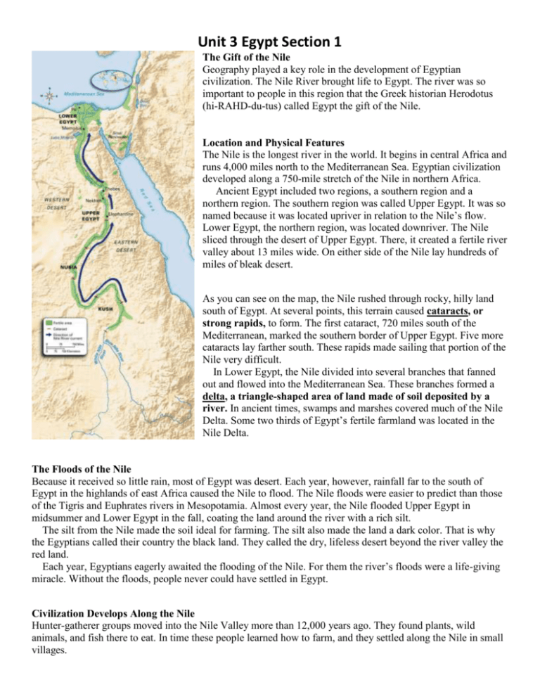
Unit 3 Egypt Section 1 The Gift of the Nile Geography played a key role in the development of Egyptian civilization. The Nile River brought life to Egypt. The river was so important to people in this region that the Greek historian Herodotus (hi-RAHD-du-tus) called Egypt the gift of the Nile. Location and Physical Features The Nile is the longest river in the world. It begins in central Africa and runs 4,000 miles north to the Mediterranean Sea. Egyptian civilization developed along a 750-mile stretch of the Nile in northern Africa. Ancient Egypt included two regions, a southern region and a northern region. The southern region was called Upper Egypt. It was so named because it was located upriver in relation to the Nile’s flow. Lower Egypt, the northern region, was located downriver. The Nile sliced through the desert of Upper Egypt. There, it created a fertile river valley about 13 miles wide. On either side of the Nile lay hundreds of miles of bleak desert. As you can see on the map, the Nile rushed through rocky, hilly land south of Egypt. At several points, this terrain caused cataracts, or strong rapids, to form. The first cataract, 720 miles south of the Mediterranean, marked the southern border of Upper Egypt. Five more cataracts lay farther south. These rapids made sailing that portion of the Nile very difficult. In Lower Egypt, the Nile divided into several branches that fanned out and flowed into the Mediterranean Sea. These branches formed a delta, a triangle-shaped area of land made of soil deposited by a river. In ancient times, swamps and marshes covered much of the Nile Delta. Some two thirds of Egypt’s fertile farmland was located in the Nile Delta. The Floods of the Nile Because it received so little rain, most of Egypt was desert. Each year, however, rainfall far to the south of Egypt in the highlands of east Africa caused the Nile to flood. The Nile floods were easier to predict than those of the Tigris and Euphrates rivers in Mesopotamia. Almost every year, the Nile flooded Upper Egypt in midsummer and Lower Egypt in the fall, coating the land around the river with a rich silt. The silt from the Nile made the soil ideal for farming. The silt also made the land a dark color. That is why the Egyptians called their country the black land. They called the dry, lifeless desert beyond the river valley the red land. Each year, Egyptians eagerly awaited the flooding of the Nile. For them the river’s floods were a life-giving miracle. Without the floods, people never could have settled in Egypt. Civilization Develops Along the Nile Hunter-gatherer groups moved into the Nile Valley more than 12,000 years ago. They found plants, wild animals, and fish there to eat. In time these people learned how to farm, and they settled along the Nile in small villages. Unit 3 Egypt Section 1 As in Mesopotamia, farmers in Egypt developed an irrigation system. They built basins to collect water during the yearly floods and to store this precious resource long afterward. They also built a series of canals that could be used in the dry months to direct water from the basins to the fields where it was needed. The Nile provided early Egyptian farmers with an abundance of food. The farmers grew wheat, barley, fruits, and vegetables, and raised cattle and sheep. The river also provided many types of fish, and hunters trapped wild geese and ducks along its banks. Like the Mesopotamians, Egyptians enjoyed a varied diet. In addition to a stable food supply, the Nile Valley offered another valuable advantage. It had natural barriers that made Egypt hard to invade. The desert to the west was too big and harsh to cross. To the north, the Mediterranean Sea kept many enemies away. The Red Sea provided protection against invasion as well. Cataracts in the Nile made it difficult for outsiders to sail in from the south. Protected from invaders, the villages of Egypt grew. Wealthy farmers emerged as village leaders, and strong leaders gained control over several villages. By 3200 BC, the villages had banded together and developed into two kingdoms. One was called Lower Egypt and the other was called Upper Egypt. Kings Unify Egypt The king of Lower Egypt ruled from a town called Pe. He wore a red crown to symbolize his authority. Nekhen was the capital city of Upper Egypt. In this kingdom, the king wore a cone-shaped white crown. Around 3100 BC a leader named Menes (MEE-neez) rose to power in Upper Egypt. He sought to finish what an earlier king, called Scorpion, had started. He wanted to unify Upper and Lower Egypt. The armies of Menes invaded and took control of Lower Egypt. Menes then united the two kingdoms. He married a princess from Lower Egypt to strengthen his control over the unified country. As Egypt’s ruler, Menes wore both the white crown of Upper Egypt and the red crown of Lower Egypt. This symbolized his leadership over the two kingdoms. Later, he combined the two crowns into a double crown. Historians consider Menes to be Egypt’s first pharaoh (FEHR-oh), the title used by the rulers of Egypt. The title pharaoh means “great house.” Menes also founded Egypt’s first dynasty. A dynasty is a series of rulers from the same family. Menes built a new capital city at the southern tip of the Nile Delta. The city was later named Memphis. For centuries, Memphis was the political and cultural center of Egypt. Many government offices were located there, and the city bustled with artistic activity. The First Dynasty lasted for about 200 years. Pharaohs who came after Menes also wore the double crown to symbolize their rule over Upper and Lower Egypt. They extended Egyptian territory southward along the Nile and into southwest Asia. Eventually, however, rivals appeared to challenge the First Dynasty for power. These challengers took over Egypt and established the Second Dynasty.
