2-2010-Darfield-background
advertisement

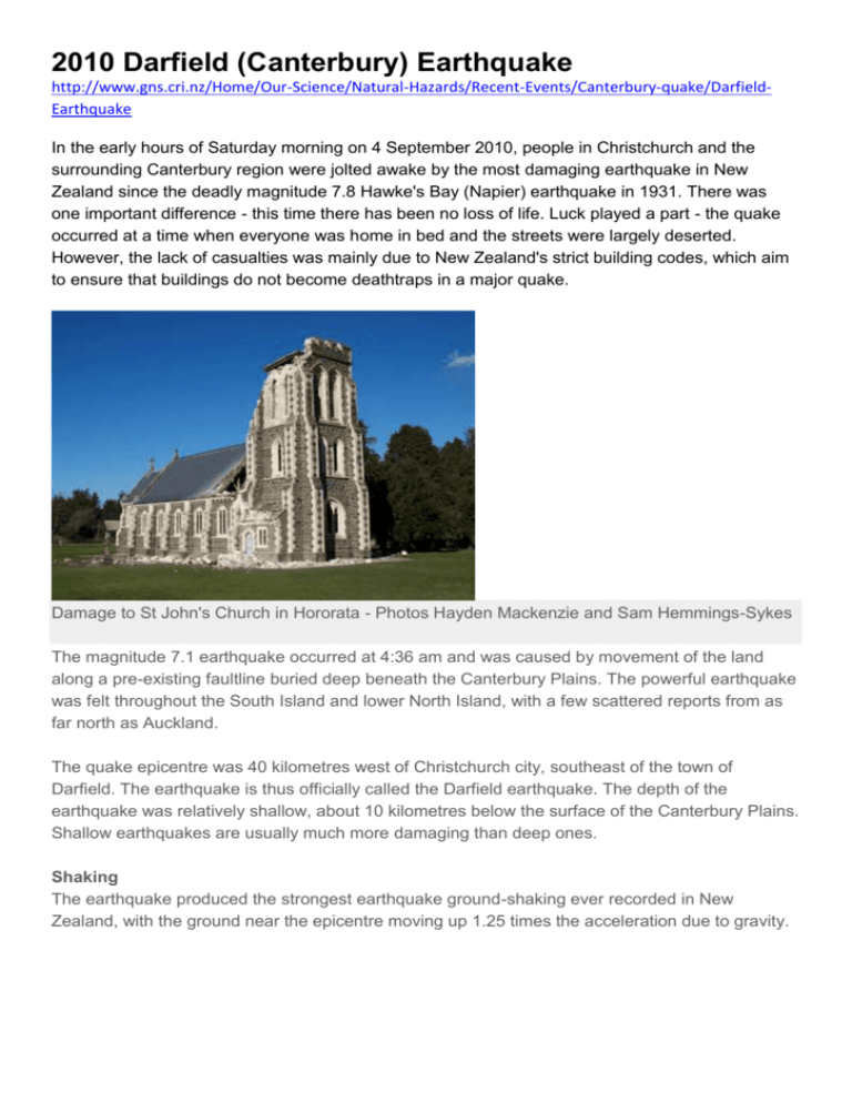
2010 Darfield (Canterbury) Earthquake http://www.gns.cri.nz/Home/Our-Science/Natural-Hazards/Recent-Events/Canterbury-quake/DarfieldEarthquake In the early hours of Saturday morning on 4 September 2010, people in Christchurch and the surrounding Canterbury region were jolted awake by the most damaging earthquake in New Zealand since the deadly magnitude 7.8 Hawke's Bay (Napier) earthquake in 1931. There was one important difference - this time there has been no loss of life. Luck played a part - the quake occurred at a time when everyone was home in bed and the streets were largely deserted. However, the lack of casualties was mainly due to New Zealand's strict building codes, which aim to ensure that buildings do not become deathtraps in a major quake. Damage to St John's Church in Hororata - Photos Hayden Mackenzie and Sam Hemmings-Sykes The magnitude 7.1 earthquake occurred at 4:36 am and was caused by movement of the land along a pre-existing faultline buried deep beneath the Canterbury Plains. The powerful earthquake was felt throughout the South Island and lower North Island, with a few scattered reports from as far north as Auckland. The quake epicentre was 40 kilometres west of Christchurch city, southeast of the town of Darfield. The earthquake is thus officially called the Darfield earthquake. The depth of the earthquake was relatively shallow, about 10 kilometres below the surface of the Canterbury Plains. Shallow earthquakes are usually much more damaging than deep ones. Shaking The earthquake produced the strongest earthquake ground-shaking ever recorded in New Zealand, with the ground near the epicentre moving up 1.25 times the acceleration due to gravity. Damaged brick building on Victoria Street in Christchurch - Photo by Ian Chan The buildings that fared worst in the shaking were those built of brick and masonry. In Christchurch, the worst affected buildings were older, often pre-World War Two, buildings on the fringes of the central business district. Some of their walls crumbled, with showers of bricks cascading onto the street, some crushing parked cars as they fell. Sadly, some historical buildings, including churches built of stone, suffered major damage, although Christchurch Cathedral survived with minor cracks. Close to the earthquake epicentre, a number of fine historic homes, such as the Deans family homestead at Homebush, were severely damaged. Brick chimneys became a danger to homes, as they toppled through roofs. One of the few cases of serious injury was caused by a falling chimney. After the initial shock, a number of people in the coastal suburbs of Christchurch feared a tsunami and headed for high ground - exactly what people near the sea should do in the event a large local quake. Fortunately, the movement of the earth had occurred too far inland to disturb the ocean floor, so there was no tsunami. Liquid silt has gushed up through cracks in the surface - Photos by Nicola Litchfield Liquefaction Damage has been heavy in Kaiapoi and some of Christchurch's eastern suburbs, where the shaking has disturbed the underlying ground. Christchurch is built on the edge of the Canterbury Plains, which are made up of deep layers of sediments deposited by rivers draining from the Southern Alps. Coarser gravels are common further inland, but close to the coast there are many layers of finer-grained sediment, such as sand, silt and clay. During the earthquake, the shaking turned some of the layers of sand and silt to liquid mush. The ground above the liquidised layers spread laterally, cracking the ground, footpaths, roads, and houses. Water and sewer pipes in the ground broke and water from the cracked mains flooded many streets. Silt from layers below oozed upward, extruding out from under house foundations and surrounding the homes with thick layers of mud. Muddy mixtures of sand and silt squirted upward through cracks to produce miniature sand volcanoes. Finding the fault line The earthquake happened in an area that has previously had few earthquakes compared to other parts of the South Island. There are some mapped faults in the region, but the fault rupture occurred along a previously unknown east-west faultline. It is buried under the gravels that were deposited on the plains at the end of the last glaciation, about 16,000 years ago. As the gravels previously showed no sign of having been disturbed, it is likely that the fault that caused the Canterbury earthquake had not moved for at least 16,000 years. Movement along the fault has broken the surface of the plains, creating a visible trace that extends east-west for about 24 kilometres, from Greendale to near Rolleston. Roads, fences, farm tracks, shelterbelts and irrigation channels that cross the fault trace have become offset, in places by over three metres. From the offsets, it is evident that movement along the fault has been mostly horizontal. Relative to the fault trace, the region north of the fault has moved eastward while the region south of the fault has moved westward. However, closer to the foothills of the Southern Alps, there is evidence of some upward vertical movement. The movements along the fault trace match the movement directions indicated by the recorded seismic waves. Aftershocks The surfaces of the blocks of land that have moved along a fault are usually irregular, and even after the main movement has occurred, small areas continue to shift and readjust, producing smaller quakes know as aftershocks. Aftershocks from a major earthquake usually continue for many days or weeks after the initial quake. Hundreds of aftershocks have occurred since the main quake on the morning of September 4th. Some of these have been strong enough to cause damage to structures that were already weakened by the main earthquake. The fault trace cuts across the once-straight Highfield Road - Photos by David Barrell During the first day after the earthquake, the aftershocks were clustered close to the east-west fault trace across the Canterbury Plains. However, movement along a fault places additional stress on the surrounding land and on the ends of the fault that haven't moved. Creeping movement may slowly extend along sections of the fault that didn't move initially. The zone of aftershocks thus has expanded over time, so it now stretches over 60 kilometres. (Aftershocks map link). At the eastern end, aftershocks now extend into the southern suburbs of Christchurch and beneath the Port Hills. Because they are so close to the city, they have been felt particularly strongly. For example, a magnitude 5.1 aftershock near Lyttelton on the morning of September 8th caused some new damage in Christchurch. The Royal Society has posted a paper from the Office of the Prime Minister's Science Advisory Committee which answers many questions related to the Canterbury Earthquakes. http://www.gns.cri.nz/Home/Our-Science/Natural-Hazards/Recent-Events/Canterbury-quake/DarfieldEarthquake


