Project Description
advertisement
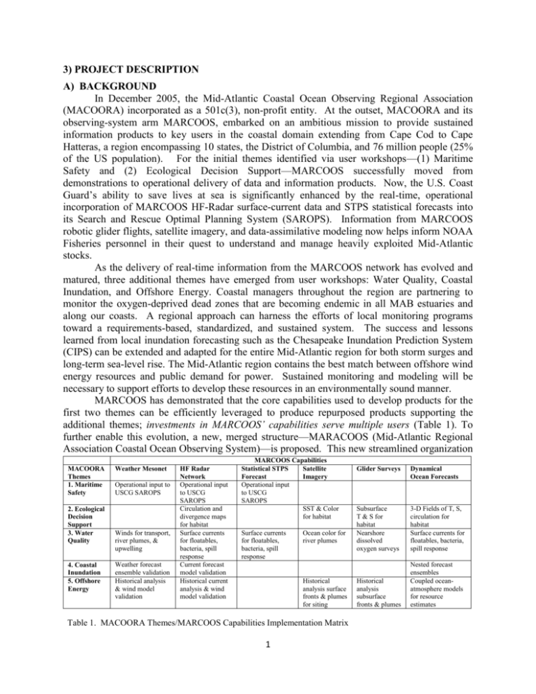
3) PROJECT DESCRIPTION A) BACKGROUND In December 2005, the Mid-Atlantic Coastal Ocean Observing Regional Association (MACOORA) incorporated as a 501c(3), non-profit entity. At the outset, MACOORA and its observing-system arm MARCOOS, embarked on an ambitious mission to provide sustained information products to key users in the coastal domain extending from Cape Cod to Cape Hatteras, a region encompassing 10 states, the District of Columbia, and 76 million people (25% of the US population). For the initial themes identified via user workshops—(1) Maritime Safety and (2) Ecological Decision Support—MARCOOS successfully moved from demonstrations to operational delivery of data and information products. Now, the U.S. Coast Guard’s ability to save lives at sea is significantly enhanced by the real-time, operational incorporation of MARCOOS HF-Radar surface-current data and STPS statistical forecasts into its Search and Rescue Optimal Planning System (SAROPS). Information from MARCOOS robotic glider flights, satellite imagery, and data-assimilative modeling now helps inform NOAA Fisheries personnel in their quest to understand and manage heavily exploited Mid-Atlantic stocks. As the delivery of real-time information from the MARCOOS network has evolved and matured, three additional themes have emerged from user workshops: Water Quality, Coastal Inundation, and Offshore Energy. Coastal managers throughout the region are partnering to monitor the oxygen-deprived dead zones that are becoming endemic in all MAB estuaries and along our coasts. A regional approach can harness the efforts of local monitoring programs toward a requirements-based, standardized, and sustained system. The success and lessons learned from local inundation forecasting such as the Chesapeake Inundation Prediction System (CIPS) can be extended and adapted for the entire Mid-Atlantic region for both storm surges and long-term sea-level rise. The Mid-Atlantic region contains the best match between offshore wind energy resources and public demand for power. Sustained monitoring and modeling will be necessary to support efforts to develop these resources in an environmentally sound manner. MARCOOS has demonstrated that the core capabilities used to develop products for the first two themes can be efficiently leveraged to produce repurposed products supporting the additional themes; investments in MARCOOS’ capabilities serve multiple users (Table 1). To further enable this evolution, a new, merged structure—MARACOOS (Mid-Atlantic Regional Association Coastal Ocean Observing System)—is proposed. This new streamlined organization MACOORA Themes 1. Maritime Safety 2. Ecological Decision Support 3. Water Quality 4. Coastal Inundation 5. Offshore Energy Weather Mesonet Operational input to USCG SAROPS Winds for transport, river plumes, & upwelling Weather forecast ensemble validation Historical analysis & wind model validation HF Radar Network Operational input to USCG SAROPS Circulation and divergence maps for habitat Surface currents for floatables, bacteria, spill response Current forecast model validation Historical current analysis & wind model validation MARCOOS Capabilities Statistical STPS Satellite Forecast Imagery Operational input to USCG SAROPS SST & Color for habitat Surface currents for floatables, bacteria, spill response Ocean color for river plumes Historical analysis surface fronts & plumes for siting Table 1. MACOORA Themes/MARCOOS Capabilities Implementation Matrix 1 Glider Surveys Dynamical Ocean Forecasts Subsurface T & S for habitat Nearshore dissolved oxygen surveys 3-D Fields of T, S, circulation for habitat Surface currents for floatables, bacteria, spill response Historical analysis subsurface fronts & plumes Nested forecast ensembles Coupled oceanatmosphere models for resource estimates is configured to meet the challenges of providing valued information products in all of our priority sectors. The merged MARACOOS will enable ocean observing in the MAB to: 1) transition from delivery of data and data products to the production of operational ocean forecasts, 2) establish operational product lines for three additional high-priority, user-driven themes, 3) formalize structures for user interaction, science-based observing, and leveraging regional efforts, and 4) extend the observing perspective toward long-term, climate-change time scales. The following proposal provides a brief report on MARACOOS progress and a 5-year plan to both enhance our core themes and expand our ability to address the additional themes. The MARACOOS activity has developed a collaborative network of some of the world’s leading scientists and business leaders who are poised to expand their efforts to address priority regional user needs. Other federal agencies have recognized the combination of scientific expertise and operational capabilities in the Mid-Atlantic with their investments in this region. The NSF Ocean Observing Initiative (OOI) has chosen the MAB for its first 5-year deployment of the Pioneer Array. The OOI Cyber-Infrastructure Implementing Organization (CI IO) chose MARACOOS as its first test bed (Schofield et al. 2010). DHS formed a Center of Excellence for Port Security in the MAB to testbed new technologies for deployment around the country, while the Navy is using the MAB to testbed new technologies for forward deployed non-collaborative environments worldwide (e.g. SW06, ESPreSSO, LEAP). The lessons learned are being translated to other regions in the U.S. and other countries around the world. The procedures developed by the MAB HF Radar network to reach operational status in USCG SAROPS are now being expanded nationally as part of the developing National HF Radar Network. The web portals, Google Earth visualization interfaces, and the virtual community blog space developed to support Glider missions in the Mid-Atlantic have been used to coordinate the national IOOS response to the Deepwater Horizon Oil Spill in the Gulf of Mexico. Now, the MAB Region is serving as an international model for cooperative research and application partnerships, especially in Europe. The forging of partnerships has been facilitated, in large part, by the sustained presence of IOOS and the collaborative spirit that pervades the MAB. MARACOOS = MACOORA + MARCOOS + Enhancements Regional Association 3. Data Management 4. Modeling & Analysis 5. Education & Outreach 3) User Needs Defines regional themes Designs, constructs & operates a Regional Coastal Ocean Observing System Engages stakeholders Met Stations Technological Capabilities HFRADAR Satellites Drifters Gliders MARCOOS 2007-Present Data Management Thredds QA/QC Asset Map Assimilation Nested Weather Forecasts NOAA-WRF Weatherflow RAMS Assimilation Nested Ocean Forecast Models UConn STPS Weather Forecast Ensemble RU ROMS RU-WRF Stevens NYHOPS SUNY UMass HOPS Visualization WWW Google Maps Google Earth User Defined Regional Themes Ocean Forecast Ensemble Leveraged Regional Weather Forecasts Enhancements 2011 MAYA 3-D Safety Ecosystem Mgmt Water Quality Flowchart. Inundation Energy Figure 1. Maritime MARACOOS Subsystem 2 MACOORA 2004 - Present Scientific Understanding Adaptive Sampling 2. Observing Subsystem 1) 2) Validation 1. Regional Management Validation B) GOALS AND OBJECTIVES Three overarching goals have been established for the MARACOOS 5-year plan. The first establishes the new proposed Regional Management Subsystem and defines its activities. The second establishes a coordinated operations network consisting of the Observing, the DMAC, and the Modeling & Analysis Subsystems. The third defines the Education & Outreach Subsystem activities. Implementation paths are illustrated in the Subsystem Flowchart (Figure 1). Goal A: Unite and integrate the organizational activities of MACOORA and the operational activities of MARCOOS into a new corporate entity, MARACOOS. Objectives include: 1. Create MARACOOS as a 501 (c) (3) Non-Profit Corporation. 2. Establish two new MARACOOS Advisory Councils and charge the existing Users Council with formulating user feedback and market development procedures. 3. Conduct program evaluation with metrics; report accomplishments & outcomes. Goal B: Maintain and expand the existing observing, data management and forecasting subsystems focused on the transition from data-generated to model-generated ensemble forecast products that can be repurposed for multiple users. Existing system objectives are to: 1. Continue to (a) operate the regional satellite, HF-Radar and glider networks, (b) leverage the public/private meteorological stations and USCG drifters, and (c) expand the capabilities within the context of the 5 regional themes. 2. Continue to employ modern DMAC technologies to centralize the data distribution and storage system with tools based on IOOS standards that provide efficient, reliable data product delivery to its data-assimilative modelers, members, partners and the general public. 3. Continue to (a) operate a suite of 4 data-assimilative ocean forecast models, (b) assemble the weather and ocean forecast ensembles weighted by extensive validation resources and (c) develop the adaptive sampling feedback for applications that support the 5 regional themes. Goal C: Expand end-to-end operations across all five regional themes through: (a) enhancing education and engagement activities, (b) leveraging resources beyond IOOS and (c) applying NFRA-endorsed metrics to measure and demonstrate success. E & O objectives are to: 1. Establish a Stakeholder Liaison position to (a) expand information dissemination facilitated by technology, (b) facilitate synthesis, integration, and translation of MARACOOS products into appropriate end uses for stakeholders, and (c) formalize a system for stakeholder feedback. 2. Informed by data & model visualization needs assessment workshops, (a) develop visualization tools and lesson materials for beta-testing, (b) obtain feedback from MARACOOS teaching faculty, and (c) transition tools and materials to the Stakeholder Liaison, University Extension Agents, Sea Grant and NERRS to train new users. 3. Refine the “Beach Basics” outreach activity following user input obtained at the 2010 MACOORA annual meeting with the currently proposed annual focus on: (a) Alongshore currents from the HF Radar network for floatables, (b) nearshore waves from HF Radar, (c) cross-shore rip currents from the correlation between waves, alongshore currents and rips, (d) weather hazards (strong winds, rain, lightning) from the forecast ensemble, and (e) waterborne bacteria impacts from correlations with rainfall, alongshore currents and waves. C) AUDIENCE AND BENEFITS The MACOORA community, guided by targeted workshops and meetings, has identified its five high priority ocean observing themes: (1) Maritime Safety, (2) Ecological Decision Support, (3) Water Quality, (4) Coastal Inundation, and (5) Offshore Energy. 1. Maritime Safety: The U.S. Coast Guard (USCG), for its Search And Rescue (SAR) mission, responds to over 28,000 incidents with over 5,000 lives saved each year. The Search And Rescue Optimal Planning System (SAROPS) is the protocol used to respond to these incidents. The effectiveness of SAROPS to define search areas depends critically on the 3 100 km 154 km observed real-time and forecast surface current data that is delivered through their Environmental Data Server (EDS). The USCG SAR operators are trained in 232 km 123 km SAROPS and educated in modern ocean observation and Figure 2: SAROPS search area using HYCOM model (left) and HF regional current conditions. Radar data (right). The 4 day drifter path (brown inverted V) is Similarly, the U.S. Lifesaving shown. Association (USLA), for its rip current safety mission, estimates that nearshore rip currents are responsible for over 100 deaths per year - the primary cause of drowning along U.S. coasts. Over 80% of the more than 12,000 annual lifeguard rescues are related to rip currents. The National Weather Service Weather Forecast Offices (NWS WFOs) provide daily rip current guidance to lifeguards’ though a rip current warning system. The accuracy of NWS rip current forecasts depend critically on the observed nearshore waves and currents that go into their statistical models. The primary data need in this regard is the alongshore drift direction and nearshore waves. Maritime Safety has been the highest priority RACOOS theme during its initial years. MARACOOS and recreational fishers jointly developed the broad support necessary to partner with NOAA’s National Data Buoy Center (NDBC) to deploy a weather buoy that provides ocean/atmosphere environmental data at the seaward end of Hudson Canyon, improving fishing safety. Advances in port and harbor maritime safety continue through the execution of a preliminary data sharing agreement between Stevens and NOAA CO-OPS. Developed at the request of the NY USCG Harbor Ops committee, under the agreement, Stevens will deliver full water column current observations from 3 locations in NY Harbor to CO-OPS at the required NOS standards for integration into the PORTS system and use by harbor pilots. The agreement leverages instrumentation funded by the NJDOT OMR for integration into the NYHOPS/MARACOOS observing system and will serve as a prototype agreement for other harbors in the region. The USCG Office of Search and Rescue and MARACOOS have jointly demonstrated that surface current maps improve the effectiveness of SAROPS. In a simulated search case, using a USCG surface drifter released south of Long Island, the USCG used surface currents from an operational HYCOM model and the MARACOOS high frequency radar (HFR) respectively with their SAROPS. The HFR surface current-derived search area (Figure 2, right) was (a) centered on the drifter and (b) 3 times smaller than that derived from the HYCOM simulation. Thus in spring 2009, HFR surface current data was installed on the USCG EDS for use as an operational component of SAROPS, an important first step toward a national capability. The USCG estimates that 50 additional lives will be saved each year after the national implementation of the HFR surface current network. The indirect benefit is that USCG assets, which are typically redirected to SAR missions, will spend more time on their law enforcement and homeland security missions. 2. Ecological Decision Support: Among the many issues requiring improved Ecological Decision Support, our region has focused its attention on fisheries, a track record MARACOOS will continue to build. Direct, indirect, and induced economic impacts of commercial and recreational fisheries in the MAB is substantial with commercial fish landing values averaging 4 close to $1.0 billion/year, and annual spending on recreational fishing estimated at $7.4 billion. MARACOOS has worked with the fisheries community to incorporate environmental observation and forecast fields to support more informed management of this valuable resource. MARACOOS has already worked with sectors of the fisheries community to identify effective ways to utilize environmental observations and forecasts. These products enable offshore recreational fishers to fish more safely and commercial fishers to fish with reduced by-catch, less disruption of the environment, and more fuel-efficient operations. In the early ‘90s, daily real-time satellite Sea Surface Temperature (SST) maps were made Figure 3. Map of satellite-derived frontal available to MAB recreational and commercial locations and strength. The inset shows the fishing communities. More recently response of the longfin squid to this index. The MARACOOS, with input from different sectors combination of the two provides information of the fishing community, has defined and built where one may be more likely to encounter more useful satellite SST products and web-based longfin inshore squid. interfaces. Leveraging IOOS supported regional ocean observing assets in the Mid-Atlantic Bight with research support from the Fisheries And The Environment (FATE) program, NOAA NEFSC and MARACOOS researchers were able to construct statistical models that linked fish abundance with observed pelagic habitat variables (Figure 3). Through direct interaction with the management community, these models are now being applied as a habitat based approach to reduce butterfish by-catch in the squid fishery throughout the MAB. 3. Water Quality: MARACOOS long-term support of water quality product delivery is expressed through a series of technical interactions with the water quality community across federal, regional, state, county and local agencies and governments. Since 2006, MARACOOS, in partnership with NOAA and others, have hosted three water-quality workshops to encourage the development of effective water quality products on all scales. At the federal level, the effectiveness of IOOS and National Water Quality Monitoring Network (NWQMN) interaction has been demonstrated through the initiation of the Delaware Bay Pilot Project. At the state level, the NJDEP and USEPA are funding dedicated glider deployments that leverage IOOS investments in the region. At the county level, the same MARACOOS HFR network that serves the USCG is used to monitor river plumes to warn of possible water quality impacts on recreational beaches. Leveraged data products such as these have been developed in response to specific needs of water quality professionals with local interests. These interactions demonstrate the benefit of leveraging the regional assets for improved monitoring of the inner shelf and estuaries to support local water quality applications. MARACOOS has helped identify priority observations that could improve water quality in the MAB; through its collaboration with the NWQMN (via its USGS representative E. Vowinkle, Co-PI). The collaboration has enabled product development such as the U. Delaware MARACOOS satellite based chlorophyll product that was used in late August this year to detect 5 lider Data: RU16 Glider track ember 10, 2010. The top left ights the glider track while the mages show the cross sections of re, salinity, density, CDOM, nd chlorophyll. a large phytoplankton bloom off coastal New Jersey. A grant from USEPA Region 2, in cooperation with NJDEP Marine Monitoring, supported a glider deployment that provided critical subsurface data (Figure 4). The USEPA and NJDEP Temperature used MARACOOS modeling support from Stevens to build a 4-d representation of the bloom that identified potential water quality impacts throughout the water column. In another example, surface current Glider Track Salinity observations, combined with regional ocean model forecasts, were used to successfully back-track the source of medical waste discovered off of an Atlantic Oxygen Density County beach at the request of NJDEP. These serve as great examples of the quality of products and support that come from strong partnerships with the growing water quality user community throughout the MAB. Chlorophyll CDOM 4. Coastal Inundation: Following the 2005 IOOS/MARACOOS inundation workshop, the Figure 4. (top left) Glider (RU16) 10 Chesapeake Inundation Prediction System (CIPS), in September 2010 track along which were response to the needs of emergency managers, measured transects of: temperature, constructed a real-time forecasting system with stormsalinity, density, CDOM, oxygen and surge visualizations down to street-level spatial chlorophyll. resolution. CIPS formed a government, academic, and private-sector partnership to produce the forecasts and deliver the information to the emergency managers to enhance their ability to respond to surges or sea-level rise. This partnership successfully used an ensemble approach that improved the accuracy of both atmospheric and water-level forecasts. One of the primary goals of CIPS was to take the lessons learned from the local Chesapeake case to expand inundation forecasting throughout the entire Mid-Atlantic Region. The inherently small space scales of inundation and the need to deal directly with the user community dictate that it will continue to be a fundamentally local process. However, significant improvements in accuracy and efficiency will accrue to these local efforts by addressing the issue from a regional perspective. Coastal and estuarine inundation modelers will be able to improve their forecasts by exploiting MARACOOS ensembles for their offshore boundary conditions. These local models are inherently more accurate because they assimilate real-time MARACOOS observations to improve estimates of upper-ocean heat content and the thickness of the wind-driven layer. In addition, coastal and estuarine inundation modelers can reduce their forecast uncertainties by exploiting the full ensemble of MARACOOS atmospheric forcing products. All these resources will be readily available for delivery from the MARACOOS servers via OPeNDAP. CIPS showed that the delivery of these products to the emergency manager in a form that can be used is at least as important as accuracy of the forecasts. For this reason, MARACOOS will be able to facilitate local inundation efforts not only through delivery of regional modeling products, but also through transferring the lessons learned through the CIPS experience of working with local emergency managers to inundation efforts throughout the region. In addition, MARACOOS will be improving the accuracy of surface wind fields through the continuing collaboration of WeatherFlow and the regional NWS Weather Forecast Offices. WeatherFlow continues to collaborate with the NWS Forecast Offices within the MARACOOS domain to build an increased understanding of surface wind fields. The ultimate goal of this effort is to build high 6 resolution and accurate gridded wind fields for meteorological applications. This product will have a broad application with the overall IOOS community. 5. Offshore Energy: Academics and industry weather forecasters in the MAB have over a decade of experience collaborating with the land-based energy industry. These collaborations have provided forecasts of summertime sea-breezes used to estimate day-ahead power consumption for improved generation efficiency, and year-round forecasts of severe weather to reduce down time from electrical grid damage. Forecasts are typically delivered through a website with an on-call meteorologist during events. The collocation of large coastal populations with Class 4 winds offshore make the MAB the most viable U.S. location for offshore wind energy to succeed. Nearly all Mid-Atlantic States already have plans in place for offshore wind resource development, with some exceeding the national target of 20% renewables by 2030. MARACOOS has responded by hosting participants from the offshore wind industry at their 2008 and 2009 annual meetings as well as a dedicated stakeholder meeting to assess their ocean observing needs. MARACOOS PIs have been requested to serve on state implementation panels throughout the region. Through these needs assessments and service opportunities, MARACOOS has learned that developers and regulators need improved understanding of the wind resource derived from high-resolution sea-breeze resolving forecasts, delivered as maps, and used as input to state GIS systems for wind farm site planning. Additionally local estimates of the wind resource and environmental conditions must be delivered as time series for historical analyses, financing, permitting, construction and operations. Better data is also needed to assess the risk of waves, currents, salt spray, and biofouling on the offshore wind farm system. Companies are assessing the cost of operation and maintenance and require wave height information to determine the number of days per month they can be working onsite and how much scour to expect around power cables and structures. Once wind farms are operating, they will need detailed and accurate wind, boundary layer, wave and current observations, and, most importantly, accurate weather predictions to compete on the day-ahead market. The benefit to society are the improved estimates of the wind resource and environmental data for wind farm siting, improved construction/operation, and improved power generation forecasts. Leveraging IOOS capabilities and expertise allows individual states to make cost effective investments in new observing system components to support the developing offshore energy industry. For example, the NJ Board of Public Utilities (NJ BPU) recommends state support for the RU-WRF weather forecasts and a nested high-resolution HF Radar network covering the inner shelf of southern NJ (see letter of support). The state funded enhancement of MARACOOS will provide a more detailed analysis of the wind resource for Marine Spatial Planning, and will develop a state-of-the-art forecasting capability for the day-ahead energy market that ultimately will reduce utility costs for the NJ rate-payer. D. WORKPLAN 1. Regional Management Subsystem. MARACOOS’s success to this point has come from prioritizing user themes, establishing partnerships, and harnessing entrepreneurial energy and competitive opportunism to operationally deliver valued information. The leadership has intentionally not invested in a large administrative structure, but rather has relied on the matching investment of host universities to support the administrative conduct of business. The new MARACOOS structure will continue to benefit from the existing relationships at Rutgers and U. Delaware. The proposed matching investments from both institutions (see letters) represent substantial and sustained contributions 7 to the enterprise, greatly enhancing the effectiveness of direct IOOS funding. The MARACOOS governance structure reflects the key role of members, who elect the Board of Directors. The Board makeup deliberately represents a broad constituency, with members from industry, government, NGOs, and academia, and a broad geographic distribution throughout the MAB. The corporation bylaws provide for systematic renewal of the Board of Directors. MARACOOS currently has 40 full dues-paying members and over 4000 stakeholders who have identified themselves as being interested in one of the five priority themes. The MARACOOS Board of Directors will retain an Advisory Council, and establish two new advisory councils. The existing Users Council will be charged with formalizing the Figure 5. MARACOOS Organizational Chart. feedback system between users and information providers and finding new markets for observing products. The Science Council will advise MARACOOS on research opportunities that leverage regional capabilities and feed back the latest scientific and technological developments on MARACOOS planning and implementation. The third group—Subregional Observing Council—will leverage and integrate successful subregional observing activities to address regional needs, forging partnerships with existing observing systems that are presently serving the large urban estuaries in the MAB. The proposed MARACOOS management plan specifies 3 new positions (Figure 5). The Managing Director of the RA (C. Thoroughgood) is responsible for coordinating the business of the organization. The Managing Director of Ocean Observing Systems (S. Glenn) will coordinate the multi-institutional, distributed ocean observing collaboration. The Stakeholder Liaison is a high-priority position with the tasks of identifying new observing opportunities and invigorating the ongoing user network feedback loop, partially through serving as Secretary of the Users Council. In addition to overseeing RA functions, the Managing Director of the RA will lead an effort to increase MARACOOS membership in number and diversity and to implement a formal evaluation procedure based on performance metrics established by IOOS. This evaluation will facilitate an application for Regional Association Certification once the procedure is established and officially promulgated. 2a. Observing Subsystem: Satellites. MARACOOS will continue to acquire satellite sea surface temperature and ocean color imagery from the ground station at Rutgers. This existing capability will be enhanced with a new satellite receive station at the U. Delaware which will be operational by the end of year 1. The addition of this station to the MARACOOS network will increase the number of satellites tracked and improve the resiliency of data collection and distribution in the MAB. With this dual station approach we will maintain the real-time de-clouded sea surface temperature and chlorophyll products delivered via OPeNDAP THREDDS, Google Earth, and standard web 8 pages to meet the needs of our broadest and most diverse user base (cover-page figure, upper left). In addition, two major new satellite products will be developed. One is a marine spatial planning product that will enable us to track the distribution of different water masses across the region and the strength of the boundaries between them (Oliver, Glenn et al. 2004; Oliver and Irwin 2008). The second will be a real-time coastal salinity product based on a locally-tuned algorithm that takes advantage of the optical properties of rivers (Geiger in prep). 2b. Observing Subsystem: HF Radar. The proposed HF Radar workplan is described in terms of (1) operations and maintenance and (2) improvements and expansions. The continued operation and maintenance of the network, one of the highest MARACOOS priorities, is essential for delivering quality controlled data to the MARACOOS modeling group, National HF Radar Network, and U.S. Coast Guard SAROPS (cover-page figure, upper left center). This will require that we maintain efficient regional coordination of technical support, track resiliency statistics so as to prioritize gap-filling needs, implement gap-filling measures as resources allow, and incorporate new sites into the regional network. Our objective is to advance our Figure 6. MARCOOS HF Radar HF Radar coverage statistics closer to the USCG target of coverage relative to NFRA endorsed 80% coverage, 80% of the time (Figure 6). This will metrics. require enhanced levels of funding for replacement spares and additional new sites. The second phase of the HF Radar workplan focuses on system improvements and enhancements to support products beyond the long-range current maps in support of USCG SAR. Specific improvement tasks are to implement Optimal Interpolation (OI) vector combination on our nested, high-resolution (25 MHz) networks, evaluate the uncertainties of radial currents as outlined in a plan co-developed with the manufacturer, and to evaluate the integration of a frequency specific bistatic vector capability. 2c. Observing Subsystem: Gliders. One of the most important subsurface physical features that structure ecological decision support in the MAB is the Cold Pool, a summertime strip of bottom trapped water stretching between Georges Bank and Cape Hatteras. Observing System Simulation Experiments (OSSEs) indicate that cross shore triangular sampling patterns are the most cost-effective glider strategy for sampling the Cold Pool. We propose to simultaneously sample 5 cross-shelf triangles twice a year, one in June after the Cold Pool has set up, and the other in late August/September just before the Cold Pool’s stormy decay (cover-page figure, center). These glider sampling times are bracketed by and thus complement the spring and fall NEFSC Fisheries cruises. Region-wide sampling will require new gliders to complement the existing MARACOOS glider fleet. These gliders will be maintained by 3 Glider Technology Centers (U. Massachusetts, Rutgers, U. Maryland), local centers of critical expertise modeled after the trio of MARACOOS HFR Technology Centers. During the early years, while the MARACOOS IOOS glider fleet is being built, existing gliders at Rutgers, UNC, U. Delaware and U. Connecticut will be employed opportunistically to conduct the proposed sampling. 9 3. Data Management and Communication Subsystem. The MARACOOS DMAC is responsible for (a) management of gridded satellite, HF radar, and model data; (b) management of glider and drifter data; (c) building data-model connections for assimilation and comparison; (d) publication of KML/Z data for use in Google Earth; (e) implementation of TDS/OPeNDAP/ncWMS and NetCDF conventions; (f) exploring the use of the Cloud for data storage and dissemination; (g) delivering data to operational users; and (h) data processing and storage within the RA. Early-on we learned that it was difficult to monitor the system and enforce consistent processes and standards for our distributed data providers; each with different storage and distribution methods. Thus (a) MARACOOS will transition to a more centralized data aggregation approach in which the DMAC team can better manage data quality, distribution, and services. (b) The MARACOOS DMAC operational data management activities, including those for the USCG Environmental Data Server (EDS), U.S. Navy MDAS and commercial GIS web services, will be leveraged in the development of a robust services-oriented system that will build tools to auto-aggregate, quality-control, and monitor the data management system for transition to operations. (c) We have learned that using open standards encourage interoperability and thus their use can be important in mission-critical applications. For example, we used an SOS client, which was first evaluated for effectiveness for critical data management support of the Deepwater Horizon response, in terms of more timely delivery of results to the responders and scientists. Such stress-testing of data standards will be used to harden the IOOS system for transition to operational status. (d) MARACOOS scientists and the DMAC team work closely with Navy’s Network-Centric Enterprise Services (NCES) and the NSF Ocean Observatories Initiative (OOI) Cyberinfrastructure Implementation Organization (CI IO), as one of the partners in the external observatories integration (EOI) task. We are following the lead of the OOI CI IO and NCES in exploring the use the revolutionary new Cloud computing for science data management. MARACOOS DMAC was involved in the federal GeoCloud initiative, is using the Amazon Cloud in a proof-of-concept demo project, and are evaluating use of the Cloud for a NOAA HPCC project. Thus MARACOOS is positioned to use the Cloud for centralized operational distribution of its data and products. MARACOOS Data Centralization Plan: The DMAC team will employ an instance of the USCG EDS to centralize MARACOOS data. Thus data will be available via such web services as KML, WFS, SOS, NetCDF, WCS, WMS, as well as those for Android/iPhone applications. The proposed system will provide (via email, SMS, or Twitter) daily reports on data issues, such as availability; greatly enhancing the robustness of MARACOOS observation and model product delivery. This “one-stop shopping” will empower all researchers, using such tools as Matlab, ESRI ArcGIS, and web-based portals and provide access to federal data warehouses, such as NDBC and Ocean NOMADS, Synthesized data products will also be made available to support regional Coast and Marine Spatial Planning (CMSP). This centralized approach will enable us to implement and compliance-check standards such as SOS, OPeNDAP/TDS, and WMS; as well as maintain and publish the data catalog and associated metadata. MARACOOS Cross-regional Collaboration Plans: The DMAC team developments will enable regional DIF coordination with interagency water quality working groups, federal and regional marine spatial planning activities, the Web Services and Data Encodings (WSDE) group, the DMAC ST, OGC, NSF OOI CI IO, and the federal Geocloud initiative. 10 TION o AVHRR REMSS TS CODAR T S ADCP OUTPUT ASSIMILA- EXTERNAL FORCING CONFIGURATION 4. Modeling and Analysis Subsystem: Weather Forecast Ensemble Validation. WeatherFlow will manage the aggregation/validation of an ensemble gridded wind product that integrates available mesoscale model outputs from NOAA, SUNY, Rutgers, and WeatherFlow’s own RAMS. Deliverables include at least two model runs per day. Additional products include: (1) a web-based map and time series viewer that displays wind vector contour plots and point location time series from each ensemble member plus the ensemble product itself; (2) a simple, but expandable gridded ensemble scheme (see ocean ensemble validation below); (3) a verification statistic tool that assesses model performance using a unique array of both terrestrial and littoral observations; and (4) a rolling archive directory of Table 2: MARCOOS Dynamic and Statistical Forecast Models Gangopadhyay Stevens/NYHOPS Blumberg Rutgers/ROMS Wilkin UConn/STPS O'Donnell NetCDF binary data files resolution 15UMass/HOPS km; 16 levels 50 m to 11 km; 10 levels 5 km; 36 s-levels 6 km; surface level Cape Hatteras - Grand Banks MD to Nantucket; high res NY Cape Hatteras - Nantucket Cape Hatt. - Cape Cod that will be sent to a domain mseas.mit.edu/HOPS www.stevens.edu/maritimeforecast myroms.org lisicos.uconn.edu model home meteorology NCEP GFS 50 km 6-hr NCEP NAM 12 km 3-hr NCEP NAM 12 km 3-hr no MARACOOS server, and rivers no NOAA AHPS 6-hr forecast USGS daily observed no water no 280 point sources no no made available for a urban tides no EastCoast2001 ADCIRC EastCoast2001 ADCIRC CODAR 6-km MAB open GS SST ring/front feature sea level NOAA ETSURGE; 1/12 HyCOM/NCODA variety of modeling uses boundaries model, dyn. adjustment none temp/salt WOA climatology w/ SSH/SST/Argo assim sequential optimal interp. sequential optimal interp. 4D-VAR strong constraint no including inundation. To method ; and blended ; / climatology; NY ; altimeter ; accomplish this, Weather- data used SST; glider / ; climatology Harbor in situ & / glider / ; / on every 7 days 1 day 1 day 1 hour Flow will provide spatial analysis data to EDS 3-hourly for 5 days 10-min averages for 2 days 2-hourly for 3 days 1-hourly for 1 day aqua.smast.umassd.edu:8080/thr colossus.dl.stevensnopp.dms.uconn.edu:8080/ validation data that include CF-compliant tinyurl.com/roms-maracoos edds tech.edu:8080/thredds thredds/catalog.html output server online browse www.smast.umassd.edu/modelin myroms.org/applications/espr lisicos.uconn.edu/map_vie publically available plots www.stevens.edu/maritimeforecast g/RTF esso wer.php?site=6kmstps_ge inter- aqua.smast.umassd.edu:8080/nc colossus.dl.stevenstashtego.marine.rutgers.edu:8 nopp.dms.uconn.edu:8080/ observations and over 100 ncWMS WMS/godiva2.html tech.edu:8080/ncWMS/godiva2.html 081/ncWMS/godiva2.html ncWMS/godiva2.html active plots hudson.dl.stevenswww.myroms.org/application nopp.dms.uconn.edu/googl of its own proprietary google earth tech.edu/maritimeforecast/google s/espresso/kmz e/6kmstps_ge.kmz network of observing sites. Ocean Forecast Generation, Ensemble Validation & Adaptive Sampling Feedback. Four systems forecasting MAB circulation were developed under MARACOOS: three dynamical data-assimilative models with different domain configurations, numerics, data inputs and assimilation methodologies, and one statistically-based surface current system using HFRADAR velocity data (Table 2). In Nov 2009 these systems supported an OOI CyberInfrastructure Observing System Simulation Experiment (CI-OSSE) that demonstrated optimal control of gliders using forecast currents. Across variables (T/S, u&v), flow regimes (nearshore, shelf-break), and durations (hourly-weekly), no single model had consistently superior skill, indicating the value of multi-model ensembles (Schofield et al, 2010). The CI-OSSE ensemble mean gave all models equal weight, but with the expanding MARACOOS data archive we can quantitatively assess skill and formulate objective weights for each model and variable. Base Level support will sustain these 4 efforts and their real-time delivery, further enhance model skill by transferring capabilities between groups, incorporate new data streams (NMFS EcoMon, OOI Pioneer) into the assimilation, and evaluate skill of each model to deliver quantitative forecast uncertainty estimates and thence an optimized multi-model ensemble prediction. Federal forecasts (NCOM & HYCOM) will be included in the multi-model ensemble. Skill assessment (year 1-2) will emphasize (i) USCG drifter data (QAQC by DMAC group) and (ii) MARACOOS glider T/S data that are not assimilated. Forecast skill with respect to not-yetassimilated data will augment this analysis, leading to all-model space/time forecast skill assessments (year 3). Multiple meteorology forecasts will expand the ensemble set. By year 4, individual forecast error estimates and the multi-model ensemble forecast will be added to DMAC services. Retrospective ensemble “best estimate” re-analyses (year 5) will support enduser applications. Enhanced Capacity funding will support glider mission planning & adaptive 11 TS CODAR AVHRR MODIS AMSR SST SSH T S XBT CTD GTS CODAR sampling, as well as enable applications pursued by individual groups on larval/disease dispersal, water-quality and DO (IOOS Super-regional Testbed), ocean-wave-atmosphere 2-way coupling, sediment transport, and inundation. 5. Education and Outreach Subsystem The MARACOOS E&O team has decades of experience developing education programs, materials and software, has focused on resource development using data from ocean observatories, and includes the NSF Centers for Ocean Sciences Education Excellence – Networked Ocean World (COSEE-NOW). New product development for MARACOOS will initially target community college and university educators to engage the undergraduate community (diverse and rich audience, geographically accessible, and directly tied to the scientists with MARACOOS data) and rapidly develop beta data products that can be repurposed for a broad range of user groups. Our premise is that student use of these data products will help us create and interpret visual representations of multi-dimensional observational data that will inform or refine our approach with public user interfaces. Stakeholder Engagement. The E&O team will be expanded to include a new Stakeholder Liaison position within the Regional Association. Working with the Executive Director, the expanded E&O team will continue the MARACOOS tradition of hosting an annual stakeholder workshop that informs implementation teams, rotating through each of the 5 regional themes. Follow-up by the E&O team will be through focus groups combining 5-8 key workshop participants with RA scientists to refine user needs with respect to RA datasets and forecasts. Our goal is to develop products that the RA Stakeholder Liaison, university extension agents, and Sea Grant personnel can promote with public audiences, and RA scientists can use in the classroom to engage the future workforce. A New MARACOOS Product Line. “Beach Basics”, our initial new product focus for years 1-5, will link strengthened observing and data management capabilities with new educational product development for improving beach safety – an issue that cross-cuts three existing regional themes including Maritime Safety, Water Quality, and Coastal Inundation. The E&O team will develop a series of data products including explanations of alongshore currents, waves, rip currents, weather (wind, rain & lighting) conditions, water quality (bacteria, floatables) and swimmer safety. Our production team consisting of a web & graphic designer, data translator, programmer, and educator will: 1) identify relevant data sets in collaboration with MARACOOS scientists, 2) develop middleware for on-demand data requests, 3) develop and test hand held apps with undergraduate students, 4) conduct needs assessments and usability testing with the User Council, and 5) revise and produce data apps for public user groups. E&O products may include but are not limited to: (a) educational data visualizations including applications for hand held devices, (b) supplemental content appropriate for end users, (c) instructor’s guides and lesson plans to help Extension professionals distribute the apps, (d) production of educational and/or promo materials (workbooks, CDs, bookmarks, posters etc), and (e) development of complementary video and multimedia pieces. Building National Synergies Among Regional E&O Efforts. COSEE-NOW is assisting NFRA leadership in creating and supporting participation from all 11 RAs in the NFRA Education and Outreach Committee. The MARACOOS E&O team will continue to work collaboratively on mutual projects including an evaluation metric development - all RAs have the need to determine if products and programs being offered are effectively engaging targeted audiences. The NFRA E&O Committee members propose to identify a common product or 12 program (following announcement of RA awards) and implement a standardized evaluation process. Results will help establish baseline metrics for determining the value of RA E&O programs and communication of information about the technologies used and the data collected as part of the Deep Water Horizon oil spill response. MARACOOS, SECOORA and GCOOS will work together to document communication strategies for rapid dissemination of information. E) MILESTONE SCHEDULE 13 MARACOOS ANNUAL BUDGET TEMPLATE: YEARS 1 - 5 F) COST PROPOSAL DISTRIBUTION BY TASK (*Industry Partners) TOTAL INSTITUTION PI The MARACOOS budget target is DESCRIPTION 1. Regional Management Subsystem Base Support $4M/year for 5 years, reflecting the Regional Association Mgmt. $400,000 U. Delaware Thoroughgood Regional Operations Mgmt. $100,000 Rutgers U. Glenn existing targets of $500K/year for Regional Management Subtotal $500,000 regional management and $3.5M/year 2. Observing Subsystem Base Support $350,000 for ocean observing. Budget allocation HF Radar Shore Site Support (35 x $10,000 / site) Rutgers (16 sites), CIT*(5 sites), U.Delaware (3 sites), criteria prioritize activities in each of U. Rhode Island (3 sites), U. Connecticut (2 sites), U. North Carolina (2 sites), Stevens Institute (1 site), the 5 subsystems, followed by the U. Massachusetts (1 site), Rutgers Spares (2 sites). Radar Technology Centers $300,000 allocation of funds to each activity, and HF (3 x $100,000 / center) $50,000 U. Massachusetts Brown finally assignment of responsible $50,000 U. Connecticut O’Donnell $100,000 Rutgers U. Kohut/Roarty institutions and personnel. The annual $100,000 Old Dominion Atkinson Radar Regional Coordinator $50,000 Rutgers U. Kohut/Roarty budget template includes Base and HF Satellite Technology Centers $100,000 Enhanced. Base support ($2.8M) (2 x $50,000 / center) $50,000 Rutgers U. Crowley $50,000 U. Delaware Oliver reflects the cost of maintaining all the Glider Technology Centers $300,000 $100,000 U. Massachusetts Brown existing functions of the RA and (3 x $100,000 / center) $100,000 Rutgers U. Schofield RCOOS. Enhanced activities ($1.2 M) $100,000 U. Maryland Boicourt Flights $200,000 are in priority order. If cuts are Glider (4 flights x $50,000 / flight) $50,000 U. Massachusetts Brown $50,000 U. Maryland Boicourt required beyond the base level, $50,000 Rutgers U. Schofield maintaining the RA activities is our $50,000 Rutgers U. TBD Observing Subtotal $1,300,000 first priority, the time series of Data Management & Communication Subsystem Base Support observations is second, and all other 3.Data Management $200,000 $175,000 Applied Science* Howlett base-level functions are third. Budget $25,000 Rutgers U. Kerfoot cuts below $2.8M will be applied with Web Site Management $100,000 $25,000 Rutgers U. Kerfoot 0 shares from Regional Management $75,000 Rutgers U. Crowley Data Mgmt & Comm Subtotal $300,000 (RM), 1 share from Observing Modeling & Analysis Subsystem Base Support Subsystem (OS), and 2 shares from 4.Weather Ensemble $100,000 Weatherflow* Titlow $100,000 U. Connecticut O’Donnell DMAC, M&A, and E&O Subsystems. Short Term Prediction System Modeling Forecast $300,000 A cut of $330K is achieved by a Dynamical Centers (3 x $100,000 / center) $100,000 U. Massachusetts Gongopadhyay $100,000 Stevens Inst Tech Blumberg reduction of 0% for RM, 10% for OS $100,000 Rutgers U. Wilkin ($130K), and 20% for DMAC ($60K), Modeling & Analysis Subtotal $500,000 5. Education & Outreach Subsystem Base Support M&A ($100K) and E&O ($40K). Education Center $100,000 Rutgers U. McDonnell 1. Regional Management Subsystem. Outreach Center $100,000 U. Delaware Thoroughgood Education & Outreach Subtotal $200,000 The priority is to maintain the regional EXISTING BASE SUPPORT TOTAL $2,800,000 management at the present level ($500K/year). The management team includes the Managing Director, the Executive Director, the Stakeholder Liaison (see E&O) and partial support for Project Coordinators and Financial Assistants (from U. Delaware). The operations management team includes the Managing Director, an Operations Manager (from Rutgers), partial support for a Program Coordinator, and a Financial Manager (Rutgers). 2. Observing Subsystem. This maintains the existing IOOS-supported HF Radars, Satellites & Gliders. HF Radar site support is at the NOAA National HF Radar Network recommended annual level of $10K/site, including communications, utilities, general site maintenance, travel, and backup media. The current network of 33 shore sites is maintained by three (Northern, Central & Southern) HF Radar Technology Centers (HFRTCs) so that all sites are within a 1-day roundtrip. Each Center (Northern Center is shared) includes about .67 FTE funding for a HF Radar technician. Despite having less than 30% of the recommended 10 technicians to achieve 14 the USCG target of 80% spatial coverage PROGRAM ENHANCEMENTS: Distribution by Task Total Institution PI 80% of the time, a viable network above Description Rutgers U. Kohut/Roarty the 60% coverage 60% of the time level of HF Radar Spares & Gap Filling $200,000 Expanded Glider Operations $300,000 reliability is maintained. This success is (6 flights x $50k / flight) $50,000 U. Massachusetts Brown supported by the HF Radar Coordination $50,000 U. Maryland Boicourt $50,000 Rutgers U. Schofield team at the level of $50K/year. Satellite $150,000 Rutgers U. TBD Technology Centers (STCs) include data Glider Purchases ($150k each) $300,000 acquisition downlinks at Rutgers (L-Band, $150,000 U. Massachusetts Brown $150,000 U. Maryland Boicourt X-Band) and U. Delaware (X-Band). The Expanded Satellite Operations $100,000 STCs include about .33 FTE of a (2 x $50k / center) $50,000 U. Delaware Oliver technician, data acquisition licensing and $50,000 Rutgers U. Crowley $200,000 software support fees, and backup media. Expanded Ocean Model Forecasts (4 x $50k / center) $50,000 U. Massachusetts Gangopadhyay Glider Technology Centers (GTCs) are $50,000 U. Connecticut O’Donnell established following the HFRTC pattern $50,000 Stevens Inst Tech Blumberg $50,000 Rutgers U. Wilkin of Northern, Central and Southern New Product Development $100,000 Rutgers U. Glenn minimizing travel costs. GTCs include .67 ENHANCEMENTS TOTAL $1,200,000 FTE of a glider technician. Glider flight TOTAL BUDGET REQUEST $4,000,000 costs are based on >175 flights; the $50K/flight cost is all-inclusive. 3. DMAC Subsystem. The team includes a DMAC Coordinator, plus part time support for programmers at ASA and Rutgers. Based on the success of the IOOS Deepwater Horizon Oil Spill Portal, Rutgers has become the RA web designer and host. An advanced data visualization developer is established as the bridge between Data and Web groups. 4. Modeling and Analysis Subsystem. An atmospheric and 4 ocean Forecasting Technology Centers (FTCs) will develop the weather and ocean forecast ensembles. The atmospheric ensemble depends on leveraged weather forecasts supported by non-IOOS funds, but with validation data from WeatherFlow’s meteorological network. The 4 ocean forecasts will be maintained by their FTC’s and assembled into an ensemble with the DMAC team. MARACOOS ANNUAL BUDGET TEMPLATE: YEARS 1 - 5 5. Education & Outreach Subsystem. Funding is DISTRIBUTION BY INSTITUTION & PI (*Industry Partners) Institution Base Enhancement Total PI for one Regional Education Center (Rutgers) and 1. U. Delaware $580,000 $50,000 $630,000 one Regional Outreach Center (U. of Del). The $500,000 $0 $500,000 Thoroughgood $50,000 $50,000 $100,000 Oliver Education effort leverages NSF COSEE-NOW $30,000 $0 $30,000 Lipphardt 2. Rutgers U. $1,005,000 $600,000 $1,605,000 and includes developers to produce Visualization $100,000 $100,000 $200,000 Glenn $330,000 $200,000 $530,000 Kohut/Roarty tools. Outreach includes the Stakeholder Liaison $150,000 $50,000 $200,000 Schofield that resides in the RA, and support for user $50,000 $150,000 $200,000 TBD-Gliders $125,000 $50,000 $175,000 Crowley identified products and workshops. $50,000 $0 $50,000 Kerfoot $100,000 $50,000 $150,000 Wilkin 6. Priority Program Enhancements. (1) HF $100,000 $0 $100,000 McDonnell 3. U. Massachusetts $310,000 $250,000 $560,000 Radar spares to reduce downtime; (2) coordinated $210,000 $200,000 $410,000 Brown 5-glider mission, bringing base level mission up $100,000 $50,000 $150,000 Gangopadhyay 4. U. Maryland $150,000 $200,000 $350,000 Boicourt to 5 coordinated gliders; (3) purchase of 5. U. Connecticut $170,000 $50,000 $220,000 O’Donnell 6. Applied Science* $175,000 $0 $175,000 Howlett dedicated instrumented gliders ($150K each); (4) 7. Stevens Inst Tech $110,000 $50,000 $160,000 $10,000 $0 $10,000 Bruno satellite enhancements to access new satellite $100,000 $50,000 $150,000 Blumberg 8. Old Dominion U. $100,000 $0 $100,000 Atkinson systems; (5) $50K for each of Ocean FTC’s for 9. Weatherflow* $100,000 $0 $100,000 Titlow adaptive sampling and theme-based coupled 10. CIT* $50,000 $0 $50,000 Vorona 11. U. Rhode Island $30,000 $0 $30,000 Ullman model development; (6) $100 K/year for new 12. U. North Carolina $20,000 $0 $20,000 Seim TOTAL BUDGET $2,800,000 $1,200,000 $4,000,000 product development and “Beach Basics”. 15
