How Do I Know Which Datum & Format My Map or GPS Is In?
advertisement

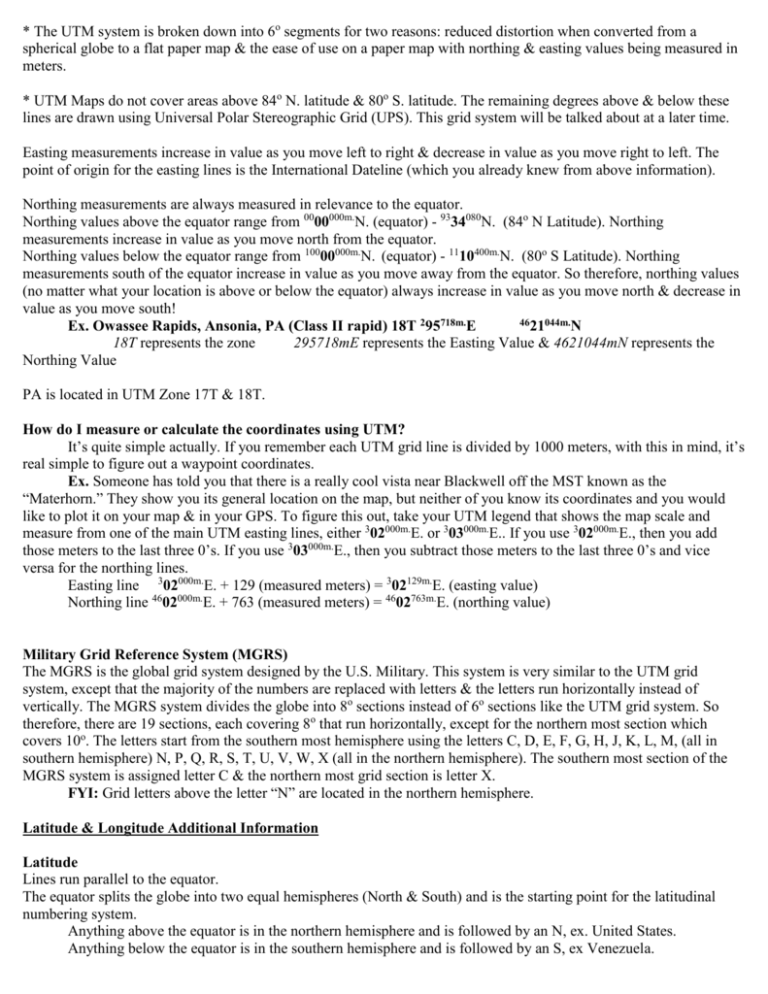
* The UTM system is broken down into 6o segments for two reasons: reduced distortion when converted from a spherical globe to a flat paper map & the ease of use on a paper map with northing & easting values being measured in meters. * UTM Maps do not cover areas above 84o N. latitude & 80o S. latitude. The remaining degrees above & below these lines are drawn using Universal Polar Stereographic Grid (UPS). This grid system will be talked about at a later time. Easting measurements increase in value as you move left to right & decrease in value as you move right to left. The point of origin for the easting lines is the International Dateline (which you already knew from above information). Northing measurements are always measured in relevance to the equator. Northing values above the equator range from 0000000m.N. (equator) - 9334080N. (84o N Latitude). Northing measurements increase in value as you move north from the equator. Northing values below the equator range from 10000000m.N. (equator) - 1110400m.N. (80o S Latitude). Northing measurements south of the equator increase in value as you move away from the equator. So therefore, northing values (no matter what your location is above or below the equator) always increase in value as you move north & decrease in value as you move south! 4621044m.N Ex. Owassee Rapids, Ansonia, PA (Class II rapid) 18T 295718m.E 18T represents the zone 295718mE represents the Easting Value & 4621044mN represents the Northing Value PA is located in UTM Zone 17T & 18T. How do I measure or calculate the coordinates using UTM? It’s quite simple actually. If you remember each UTM grid line is divided by 1000 meters, with this in mind, it’s real simple to figure out a waypoint coordinates. Ex. Someone has told you that there is a really cool vista near Blackwell off the MST known as the “Materhorn.” They show you its general location on the map, but neither of you know its coordinates and you would like to plot it on your map & in your GPS. To figure this out, take your UTM legend that shows the map scale and measure from one of the main UTM easting lines, either 302000m.E. or 303000m.E.. If you use 302000m.E., then you add those meters to the last three 0’s. If you use 303000m.E., then you subtract those meters to the last three 0’s and vice versa for the northing lines. Easting line 302000m.E. + 129 (measured meters) = 302129m.E. (easting value) Northing line 4602000m.E. + 763 (measured meters) = 4602763m.E. (northing value) Military Grid Reference System (MGRS) The MGRS is the global grid system designed by the U.S. Military. This system is very similar to the UTM grid system, except that the majority of the numbers are replaced with letters & the letters run horizontally instead of vertically. The MGRS system divides the globe into 8o sections instead of 6o sections like the UTM grid system. So therefore, there are 19 sections, each covering 8o that run horizontally, except for the northern most section which covers 10o. The letters start from the southern most hemisphere using the letters C, D, E, F, G, H, J, K, L, M, (all in southern hemisphere) N, P, Q, R, S, T, U, V, W, X (all in the northern hemisphere). The southern most section of the MGRS system is assigned letter C & the northern most grid section is letter X. FYI: Grid letters above the letter “N” are located in the northern hemisphere. Latitude & Longitude Additional Information Latitude Lines run parallel to the equator. The equator splits the globe into two equal hemispheres (North & South) and is the starting point for the latitudinal numbering system. Anything above the equator is in the northern hemisphere and is followed by an N, ex. United States. Anything below the equator is in the southern hemisphere and is followed by an S, ex Venezuela. The Equator line of latitude is 0o. The North Pole line of latitude is 90o. The South Pole line of latitude is 90o. 1o of latitude is 69.05 miles or 111.12km. 1’ is one nautical mile, which is 1.15 miles or 1.85 km. 1” is .019 miles or about 100 feet or 33.5 yards or .03 km 1000th of a minute is 6 feet or 2 yards Longitude Lines run from the North Pole to the South Pole, so therefore all lines of longitude converge at the poles. The Prime Meridian crosses through Greenwich, England and is the starting point for the longitudinal numbering system. The Prime Meridian line of longitude is 0o. The International Dateline of longitude is 180o East &/or West and is directly opposite of the Prime Meridian. Anything to the right (east) of the Prime Meridian increases in number and is followed by an E for east. Anything to the left (west) of the Prime Meridian increases in number and is followed by a W for west. 1o of latitude is 69.05 miles or 111.12km at the equator and slowly decreases in distance as you approach the poles. 1’ is one nautical mile, which is 1.15 miles or 1.85 km at the equator and slowly decreases in distance as you approach the poles. 1” is .019 miles or 100 ft or 33.5 yds or .03km and slowly decrease in distance as you approach the poles. 1000th of a minute is 6 feet or 2 yards and slowly decrease in distance as you approach the poles. Coordinates Generally written hemisphere latitude & hemisphere longitude Coordinates may be expressed in three different formats: Degrees, Minutes, Seconds: 41o19’ 30” N 76o17’07” W 60” seconds to 1’ minute 60’ minutes to 1o 180o to one eastern or western hemisphere & 90o to one northern or southern hemisphere. Degrees, Decimal Minutes: 41o19.505’ N W 76o17.113’ W 60’ minutes to 1o 1000 1000th to 1’ minute Decimal Degrees: 41.32508o N 76.285222oW 100,000 decimal degrees to 1o *The coordinates above are for the Ganaga Falls (100’+) located in Ricketts Glenn State Park off Rt.118. Coordinate Example in "National Geographic TOPO!" Software Ex1. Ex2. Ex3. 41°26'38" N 41°26.626' N 41.44377° N 76°40'43" W 76°40.713' W 76.67855° W in Degrees, Minutes & Seconds in Degrees & Decimal Minutes in Decimal Degrees The above coordinates are for "High Knob Vista," which is absolutely amazing and gigantic. This vista looks out over 7 counties in PA. I would recommend anyone to see this vista and on the way up stop and check out Dry Run waterfalls off the road. Coordinate Example When Using Garmin's "GPSMap 60CSx" Ex1. Ex2. Ex3. 41°25'49.1" N 41°25.826' N 41.43043° N 76°40'14.0" W 76°40.234' W 76.67056° W in Degrees, Minutes & Seconds in Degrees & Decimal Minutes in Decimal Degrees The above coordinates are for “Dry Run Waterfalls Parking Area” located off Dry Run Road, which is accessible off Rt.87. The Dry Run Waterfalls are a very pretty waterfall that is at least 20' high. Both examples listed above give three coordinates formats for the same location. They are just listed in the 3 formats that the Latitude & Longitude Grid System can use Most GPSr allow you to select a multitude of formats. How Do I Know Which Datum & Format My Map or GPS Is In? To figure out how your map has been setup look over the legend and look to the edges of the map. The USGS Topo! software tells you the datum used in the upper right & lower right-hand corners. It can also generate maps in four formats (3 lat. & long. & UTM). The format markings are along the outer edges of the map & would contain the coordinates. The USGS maps you would purchase at outfitters are 7.5’ topographic maps. You will find (9) 2.5’ blocks on each map. 7.5’ is the distance it covers in both directions using the latitude & longitude grid system. It will also contain the UTM grid system with markings every 1000 meters. The map below would contain UTM marks from: 4584 – 4597 for northing (south to north) & 291 – 301 for eastings Ex. Map Name: Cammel, PA Northern Corners: 41o30’00” N. 77o30’00” W. 41o30’00” N. 77o22’30” W. 45 97 N. 45 84 N. 291 E. Southern Corners: 41 22’30” N. 77 30’00” W. o o 3 01 E. 41o22’30” N. 77o22’30” W. Midpoint of Map 41o26’15” N. 77o26’15” Latitude & Longitude Degrees, Minutes& Seconds: The map is divided by tick marks every 30” for both lat. & long. Degrees & Decimal Minutes: The map is divided by tick marks every 500’ for both lat. & long. Decimal Degrees: The map is divided by tick marks every .00833o for both lat. & long. UTM Eastings: The map is divided by tick marks every 805 meters (.5 miles). Northings: The map is divided by tick marks every 805 meters (.5 miles).


