Georeferencing Train-the-Trainers Workshop #2 Pre
advertisement
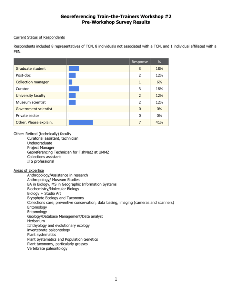
Georeferencing Train-the-Trainers Workshop #2 Pre-Workshop Survey Results Current Status of Respondents Respondents included 8 representatives of TCN, 8 individuals not associated with a TCN, and 1 individual affiliated with a PEN. Response % Graduate student 3 18% Post-doc 2 12% Collection manager 1 6% Curator 3 18% University faculty 2 12% Museum scientist 2 12% Government scientist 0 0% Private sector 0 0% Other. Please explain. 7 41% Other: Retired (technically) faculty Curatorial assistant, technician Undergraduate Project Manager Georeferencing Technician for FishNet2 at UMMZ Collections assistant ITS professional Areas of Expertise Anthropology/Assistance in research Anthropology/ Museum Studies BA in Biology, MS in Geographic Information Systems Biochemistry/Molecular Biology Biology + Studio Art Bryophyte Ecology and Taxonomy Collections care, preventive conservation, data basing, imaging (cameras and scanners) Entomology Entomology Geology/Database Management/Data analyst Herbarium Ichthyology and evolutionary ecology invertebrate paleontology Plant systematics Plant Systematics and Population Genetics Plant taxonomy, particularly grasses Vertebrate paleontology 1 Teaching Experience Response % 1 semester or less 5 29% 1 to 3 years 8 47% 4 to 7 years 2 12% More than 7 years 2 12% Total 17 100% Response % Middle school students 2 13% High school students 6 40% Undergraduate students 15 100% Graduate students 5 33% Continuing education 1 7% Lay public 2 13% Other. Please explain. 1 7% Types of Students Taught (multiple answers allowed) Other: Museum staff Experience with Different Instructional Formats (multiple answers allowed) Response % Hands on computer lab 6 40% Science lab 14 93% Small group/discussion section 13 87% Seminar 8 53% Large lecture 6 40% Online course 1 7% Field setting 8 53% Workshop 5 33% 2 Courses/Subjects Taught (summarized across all answers – into a tag cloud) What types of vouchered specimens have you georeferenced? Response % Mammals 3 18% Herps 1 6% Fossils 4 24% Birds 2 12% Plants 9 53% Fish 4 24% Insects 3 18% Fungii and lichens 1 6% Other. Please explain. 2 12% Other: Geology, Geological materials Specimen Types Georeferenced (summarized across all answers – into a tag cloud) 3 Tools Used to Georeference (Multiple answers possible) Response % ArcGIS 3 18% DIVA-GIS 1 6% GEOLocate 11 65% BioGeomancer 5 29% Google Maps 12 71% Google Earth 12 71% TopoMaps 5 29% TRS2LL 1 6% Other. Please list. 4 24% Other: Alexandria Digital Gazetteer National Geographic Topo Mexican INEGI website, GeoNames (NGA), general Google searches including Google Scholar Custom google map layers Data Management Software Currently Used or Planned to Be Used (Muliple Answers) Response % Arctos 0 0% KE EMu 2 12% Microsoft Access 3 18% Microsoft Excel 8 47% Specify 7 41% Symbiota 5 29% Other. Please list. 6 35% Other: Filemaker Arthropod Easy Capture GeoLocate Possibly Muse, as we migrate from Muse to KE EMu TROPICOS, personal custom PostgreSQL database MIMSY XG/Oracle 4 Number of datasets and institutions involved Number of people expected to do the georeferencing Approximate number of unique locality records across all datasets Approximate number of specimens records Percentage of records within the US 2 3-4 1,000+ 90,000+ 80 ca. 50+ datasets and institutions ? 200+ ? 1,000,000? 3,000,000? 90% 1 7-10 10000+ 10000+ over 70% Datasets? Institutions, 100+ hundreds The PaleoDB currently holds 145,026 fossil collections . The PaleoDB currently holds 1,117,319 fossil occurrences. Currently, 28% of the collection records in the PaleoDB are from the US. 20-30 3-4 30,000 500,000 45% 50? Depends how many really want to participate Have not a clue; want to expand this beyond museum personnel. There are >13,000000 records in the region's herbaria ~10% (taking 116 million as being a reasonable estimate of all herbarium specimens in US 2.3 million 100% US, Canada and Mexico It would depend on what you mean by "unique locality" Over 60 35 Unknown 170,000 over 1 million 70% 1, 1 10+ 50,000 200,000 80% 1 5 12,500 20,000 100% 6; 5 institutions 6-12 Unsure, but probably very high 400,000 95% about 65 institutions 12 principal georeferencers; 15 or 20 total 6 institutions, 5 datasets 4 at KU 5,000-7,000 170,000 100% 60 unknown unknown 2.3 million unknown 10 biological datasets; 1 institution (NYSM) 5-10 staff + volunteers and interns as available 45000 250,000 95% hundreds of thousands of records 2-3 5 Level of Geographical Scale Used in Georeferencing Response % Point + uncertainty measure (polygon and or radius) 12 75% Point only 4 25% Area (polygons) 1 6% Town 4 25% County 5 31% State/Province 5 31% Regional 2 13% Other. Please explain. 2 13% Other: Depends on when it was done. Combines point, uncertainty radius, plus polygon Estimate of Number of Records in Respondents’ Collection Georeferenced by Workshop 0 1200 147,000 10% 50600 with lat long; 2600 with datum (which probably means they have uncertainty). 0% 30,000 10,000 5-10 2000 1500 unknown 6500 6 Level of Interest in Various Workshop Topics (Highest to Lowest) Very Very high High Medium Low low Online tools for georeferencing (Google Maps, Online Gazetteers etc.) No opinion Mean 12 5 0 0 0 0 1.29 11 4 2 0 0 0 1.47 12 2 2 1 0 0 1.53 10 8 3 5 4 4 0 0 0 0 0 0 1.65 1.76 7 7 3 0 0 0 1.76 9 5 2 0 1 0 1.76 7 7 2 1 0 0 1.82 8 3 6 0 0 0 1.88 7 5 5 0 0 0 1.88 8 2 4 2 0 1 2.24 How to plan a successful Georeferencing Workshop 6 5 3 2 0 1 2.29 Using crowd-sourcing to facilitate georeferencing Geographical concepts 7 2 3 8 4 6 1 0 2 0 0 1 2.29 2.47 2 7 3 3 1 1 2.82 3 1 5 1 3 5 2 7 3 3 1 0 3 3.59 Semi-automated tools for georeferencing (GEOLocate and Biogeomancer) Data cleaning, processing, and analysis (Google Refine, Refine Call to GEOLocate, rproject, RStudio, QuantumGIS, QGIS Basic Operations, Sample Data Set) Collaborative georeferencing using GEOLocate Localities and locality descriptions Post automation validation (e.g.,checking the results of georeferencing are in the appropriate county or elevation, match taxonomic distributions, etc) Examples of possible workflows using GEOLocate, Symbiota and/or Specify Working with polygons and representing localities as polygons Darwin Core and the Georeferencing Template Data preparation/cleaning (e.g., Global Administrative Areas) Writing scripts to automatically georeference and validate data using GEOLocate web services for georeferencing and taxon distribution validation and USGS web services for elevation validation. First pass georeferencing to county or town centroids Open Work Sessions - Participant/TCN Georeferencing Projects (use your own data sets) Georeferencing using paper maps Other topic of interest: Examples of use of data that actually use the uncertainty and datum information. I presume they are out there. 7 Likely Maximum Duration and Attendance in Respondents’ Own Workshop Number of People to Train 6–8 20 15 – 30 30 15 10 "large number of attendees" Notes undergraduate or graduate students Time Frame 4 -5 hours 1 day 3 days 2- 3 days 2, max 3 1 day a larger public-oriented workshop in order to raise awareness and increase knowledge of our project. 5 – 10 ½ day undergraduate students 6 - 10 20+ 2 days 3 – 5 days 15 <=20 3 days 3 days Questions/Concerns about Own Workshop (summarized) Content to cover motivating people to attend technology needs. Having enough computers for students to work through their own datasets Cost associated Funding attendance and persuading people it would be worth their time. nice to develop some lesson plans to have a guide for the workshop. do I have the expertise needed for putting together a workshop? How do you present the easiest workflow for georeferencing? What is the most important information, activities to do to get people going on their own georeferencing projects? Should students be involved in the workshop or left to be trained by participants in the workshop? all of the above! (content to cover, selecting a venue, technology needs) See you soon in Gainesville. From all of us in the GWG, thanks, participants, for your survey input! 8
