WORD
advertisement
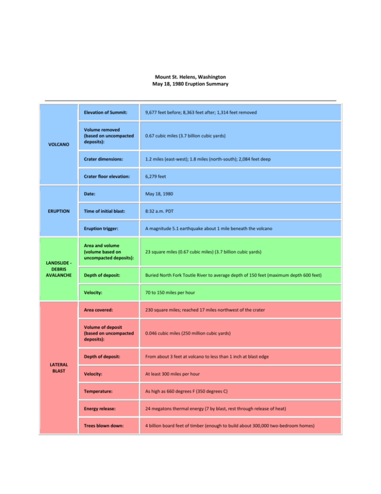
Mount St. Helens, Washington May 18, 1980 Eruption Summary VOLCANO ERUPTION LANDSLIDE DEBRIS AVALANCHE LATERAL BLAST Elevation of Summit: 9,677 feet before; 8,363 feet after; 1,314 feet removed Volume removed (based on uncompacted deposits): 0.67 cubic miles (3.7 billion cubic yards) Crater dimensions: 1.2 miles (east-west); 1.8 miles (north-south); 2,084 feet deep Crater floor elevation: 6,279 feet Date: May 18, 1980 Time of initial blast: 8:32 a.m. PDT Eruption trigger: A magnitude 5.1 earthquake about 1 mile beneath the volcano Area and volume (volume based on uncompacted deposits): 23 square miles (0.67 cubic miles) (3.7 billion cubic yards) Depth of deposit: Buried North Fork Toutle River to average depth of 150 feet (maximum depth 600 feet) Velocity: 70 to 150 miles per hour Area covered: 230 square miles; reached 17 miles northwest of the crater Volume of deposit (based on uncompacted deposits): 0.046 cubic miles (250 million cubic yards) Depth of deposit: From about 3 feet at volcano to less than 1 inch at blast edge Velocity: At least 300 miles per hour Temperature: As high as 660 degrees F (350 degrees C) Energy release: 24 megatons thermal energy (7 by blast, rest through release of heat) Trees blown down: 4 billion board feet of timber (enough to build about 300,000 two-bedroom homes) 57 Human fatalities: Velocity: About 10 to 25 miles per hour (over 50 miles per hour on steep flanks of volcano) Damaged: 27 bridges, nearly 200 homes. Blast and lahars destroyed more than 185 miles of highways and roads and 15 miles of railways. Effects on Cowlitz River: Reduced carrying capacity at flood stage at Castle Rock from 76,000 cfs (cubic feet per second) to less than 15,000 cfs Effects on Columbia River: Reduced channel depth from 40 to 14 feet; stranded 31 ships in upstream ports Height: Reached about 80,000 feet in less than 15 minutes Downwind extent: Spread across U.S. in 3 days; circled Earth in 15 days Volume of ash (based on uncompacted deposits): 0.26 cubic miles (1.4 billion cubic yards) Ash fall area: Detectable amounts of ash covered 22,000 square miles Ash fall depth: 10 inches at 10 miles downwind (ash and pumice); 1 inch at 60 miles downwind; 1/2 inch at 300 miles downwind Area covered: 6 square miles; reached as far as 5 miles north of crater Volume and depth (volume based on uncompacted deposits): 0.029 cubic miles (155 million cubic yards); multiple flows 3 to 30 feet thick; cumulative depth of deposits reached 120 feet in places Velocity: Estimated at 50 to 80 miles per hour Temperature: At least 1,300 degrees F (700 degrees C) Wildlife: The Washington State Department of Game estimated nearly 7,000 big game animals (deer, elk, and bear) perished as well as all birds and most small mammals. Many burrowing rodents, frogs, salamanders, and crawfish, managed to survive because they were below ground level or water surface when the disaster struck. Fisheries: The Washington Department of Fisheries estimated that 12 million Chinook and Coho salmon fingerlings were killed when hatcheries were destroyed. Another estimated 40,000 young salmon were lost when forced to swim through turbine blades of hydroelectric generators as reservoir levels along the Lewis River were kept low to accommodate possible mudflows and flooding. LAHARS ERUPTION COLUMN AND CLOUD PYROCLASTIC FLOWS OTHER


