Geological Dating Lab: Relative & Absolute Age
advertisement
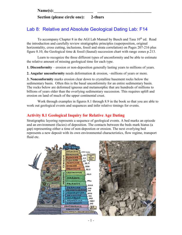
Name(s):___________________ __________________________ Section (please circle one): 2-thurs Lab 8: Relative and Absolute Geological Dating Lab: F14 To accompany Chapter 8 in the AGI Lab Manual by Busch and Tasa 10th ed. Read the introduction and carefully review stratigraphic principles (superposition, original horizontality, cross cutting, inclusions, fossil and strata correlation) on Pages 207-216 plus figure 8.10, the Geological time & fossil (faunal) succession chart with range zones p.213. Learn to recognize the three different types of unconformity and be able to estimate the relative amount of missing geological time for each type. 1. Disconformity – erosion or non-deposition generally lasting years to millions of years. 2. Angular unconformity needs deformation & erosion, ~millions of years or more. 3. Nonconformity marks erosion clear down to crystalline basement rocks below the sedimentary basin. Often this is the basal unconformity for an entire sedimentary basin. The rocks below are deformed igneous and metamorphic that are hundreds of millions to billions of years older than the overlying sedimentary succession. This requires uplift and erosion on land of much of the upper continental crust. Work through examples in figures 8.1 through 8.9 in the book so that you are able to work out geological events and sequences and infer relative timings for events. Activity 8.1 Geological Inquiry for Relative Age Dating Stratigraphic layering represents a sequence of geological events. A bed marks an episode and an environment (facies) of deposition. The contacts between the beds mark hiatus (a gap) representing either a time of non-depostion or erosion. The next overlying bed represents a new deposit with its own environmental characteristics, flow regime, transport fluid etc. -1- The cartoon on the left represents all of Earth History, but really captures a thorough record of the Phanerozoic Eon, with all of its Geological Periods and major changes in life forms from the cartoon fossil record. In any place on Earth we tend to find less complete records, but segments of shorter duration that preserve more detail for that interval of the stratigraphic record. The photo above on the right is of the “Amherst Clay” from de-glacial lake Hitchcock (~10 Ka). The dark and light grey layers here in Ben Keisling’s photo (University of Massachusets) represent annual varves of dark fine grained winter clay and lighter summer sands from meltdown of the ice. These are thought to capture El Niño Climate cycles according to Rittenour et al.(2000). A. Ink in the stratigraphic contacts between the “thumb” thick varves (1-2 cm) in the photo on the right. The cleaned face has annual layers representing ________ years of deposits. (2) B. Examine the photo at the bottom of page 217 in your manual. There are about 4 distinct layers here. There is grass (1) is growing on a thin (~40 cm) brown soil (2). The soil is developed on a 2.4 m thick columnar jointed brown basalt flow (3) mapped as 7 Ma Rim Basalt near Sedona. Under this are Pangaea supercontinent red beds (4) (ancient continental soils of Permian Age, Schnebly Hill Formation). This is a lot of geological history to pack into a mere 5-6 metres of outcrop, but stratigraphy has more missing time than represented by the layers themselves. 1. Even if I hadn’t told you the redbeds were the oldest, how can you look at this outcrop and tell their relative age? _________________________________________________ (1) What stratigraphic principle did you use to determine this relationship? _____________ ______________________________________________________________________ (1) 2.a. The uppermost contact between the buried red soil and the overlying lava flow varies from less than 10 cm to more than 20 cm thick and it is more intensely red than the underlying soils. What kind of a contact is this, (what did the lava do to the soil)? _____ ______________________________________________________________________ (1) 2.b. Why is the top of the solid rocky cliff-forming basalt flow uneven and how did it come to be this way? __________________________________________________________ (1) 3. Notice the vertical fractures in the basalt flow. Are they younger or older than the basalt flow? a) younger b) older (1) How do you know this? ___________________________________________________ (1) 4. Notice the angular brown clasts of basalt in the overlying brown soil. Are the clasts older or younger than the soil which surrounds them? a) younger b) older (1) How do you know this? ___________________________________________________ (1) Angular Unconformities: Unconformities mark missing time in the local rock record. Angular unconformities are easy to spot because the strata meet at an angle where the underlying beds have been eroded off and capped by later sediments. All sediments are more or less deposited in horizontal strata. The angle means the underlying rocks not only had time to be deposited and lithified, but also time enough to become folded, uplifted and eroded. This is essentially a mountain building episode and subsequent erosion all reduced to that single angular contact. When James Hutton found the famed angular unconformity at Siccar Point, he realized the significance and on that day, he discovered “Deep Time”. The photo below shows: Monterrey diatomite turbidites of Middle 16 Ma to Upper 6 Ma age. These deposits were laid down in deep cold offshore basins, then compacted, tilted uplifted and eroded near Montaña del Oro State Park near Obispo County California. This -2- has been stripped bare along the modern beach, but is capped by older uplifted beach deposits of > 125,000 year age from the penultimate sea level highstand. Here the 2 sedimentary layers not only happened at very different times, but in different facies or environmments. This is close to the San Andreas Fault where the Pacific Plate is dragging the edge of North America to the Northwest (recall lab 2.7 on p.66 & 67). Ink in bedding planes & angular unconformity here! Examine the photo, that on p.218 and Figures 8.4 & 8.5 p.210. In your manual, the photo shows buff coloured horizontal gravel (Late Tertiary continental fan deposits of Arizona, in modern North America) overlying Continental Red-bed sandstones (pre-Middle Triassic 225 Ma of the Moenkopi Formation of Pangea) that became folded later in Cretaceous time during the uplift of the Colorado Plateau. C.1. In the photo above, ink bold BLUE lines between the diatomite layers. (1) Assuming that the cream coloured diatomites were originally more horizontal, Explain what process caused them to become tilted (folded) this way. ___________________________ ________________________________________________________________________ _______________________________________________________________________ (2) C.2 Ink in the Angular unconformity on the photo above in Red and measure the angle between the unconformity (horizontal) and the left dipping diatomite beds . angle ____ ° (2) What sequence of events is represented by the line (planar surface) of the unconformity, even though there is no rock layer present to record this? _________________________ ________________________________________________________________________ _______________________________________________________________________ (2) D. Reflect and discuss from your exercises in B and C and list the rules or guidelines a Geologist must follow to determine what age is represented by rocks in a given layer and for the ages of the gaps between those layers. ______________________________________ ________________________________________________________________________ ________________________________________________________________________ ________________________________________________________________________ ________________________________________________________________________ _______________________________________________________________________ (3) -3- Activity 8.2 - Determining the Sequence of Events in a Geological Cross Section Examining Geological Cross Sections: Cross sections of rock strata: canyon walls, cutbanks of streams, eroded cliffs, road cuts, valley walls represent the layered view of the Earth. Often there is no convenient exposure and a geologist has to make their own cross section from subsurface borehole or geophysical information. In all of these sections, the uppermost layer is the youngest, but unless you are standing up to your “@ρ$ə” in mud, the youngest layer is not a modern Zero-age deposit but rather an unconformity of some kind eroded down to some prior layer and time in Earth History. There is no single place on Earth thick-enough, nor complete-enough to record all of geological time. Because of this, we need to piece it together, much like a jigsaw puzzle, to build up the entire geological time column. There are widespread younger deposits, but the older parts of geological record, like so many unconformities have often been entirely eroded away or are too deep to be exposed at all. A. There are 4 cross sections, 3 of these are hypothetical ones but the second one is real and represents the Inner Gorge of the Grand Canyon of the Colorado. Note the legend blocks below so you can tell igneous intrusions which baked the rocks they cut from eroded plutons covered by gravel of their own detritus. Generally sediments are deposited in horizontal layers. If they are dipping (tilted) there has been enough time after their deposition and lithification to uplift and erode them in a mountain building episode. In geological sequences, unconformities for erosion or non-deposition actually represent more missing time than is represented by the deposition of a single layer or sequence. Therefore, we include unconformities in the sequence as they represent the biggest blocks of time. Often an unconformity is more than one type depending on what the underlying layer is like. For example a flat lying strata that overlies both dipping beds and crystalline rocks is both an angular unconformity and a non-conformity. The present day erosional surface (nonconformity) on the Canadian Shield (and the same as “S” the one in the base of the Grand Canyon of the Colorado) is missing on average 2.5 Ga or a little over half of Earth history! List letters and unconformity types (Dis, Ang, Non), top downwards = Youngest to Oldest, next to each cross section. Geological Section 1 (21 points) -4- Inner Gorge Grand Canyon - Geological Section 2 (see Activity 8.2 p 219 (17 points) B. This is a cross section of the bottom, innermost layers of the Grand Canyon near Bright Angel Falls. There are more layers on top of this all the way up to the Permian Kaibab Limestone of the South Rim. After you have completed all 4 cross sections, come back to this point to discuss with lab partners, what “Geological laws” of Relative Dating you would need to piece in the missing time and rock layers from the 2 unconformities in your section above of the inner Gorge. On the section above ink in a series of dashed lines for the contacts of the missing layers. Discuss the Laws here and ink in the dashed contacts above. ___________________________________________ _____________________________________________________________________________ _____________________________________________________________________________ _____________________________________________________________________________ _____________________________________________________________________________ _____________________________________________________________________________ _____________________________________________________________________________ _____________________________________________________________________________ _____________________________________________________________________________ _____________________________________________________________________________ _____________________________________________________________________________ _____________________________________________________________________________ _____________________________________________________________________________ __________________________________________________________________________ (10) -5- Geological Section 3 (18 points) Geological Section 4 (27 points) -6- Activity 8.3 Using Index Fossils to Date Rocks and Geological Events (replacement for labbook p.221 questions. The geological time column (Figure 8.10 above) is divided into Periods (several tens of Ma) with names like Ordovician (for a tribe along the coast of Wales) or Cretaceous (for the age of chalk). The Tertiary Period is further subdivided into: Paleocene, Eocene, Oligocene, Miocene and Pliocene. Fossils are unique impressions or mineral replacements of once living biota. The average lifetime of a species, be it a microscopic species of plankton or a massive mammal, is about 2 Ma. Thus recognizing and telling one fossil species from another gives a pretty well defined interval of time. Groups of closely related animals live longer than individual species. For example there have been horse-shoe crabs since the Lower Paleozoic, but there have been hundreds if not thousands of different species. Index fossils are widespread but short lived and thus are very useful to tell the relative “Geological ages” of different strata, -7- for example Middle Cambrian versus Late Devonian. Marine strata preserve the best fossil records. Before radiometric age dating became possible in the 1960’s, geologists knew that Cambrian was older than Permian, but not by how much or when either of them was in terms of absolute age. Paleontologists use the overlapping and sequential range zones of different groups of fossils. Identifying species with easily distinguished shapes is the key to interpreting relative ages. Now that we have used volcanic ash beds or lavas intercalated with sediments to assign absolute radiomentric ages, we know the Cambrian began 543 million years ago. Be as precise as you can in assigning the Period names such as Early Middle or Late, depending on when the fossil’s range zone starts or ends. Finally, using the absolute age scale along the left edge of the diagram, assign an absolute age to the fossil assemblage pictured. When Paleontologists use many species to constrain this the precision improves down to the level of +/- 0.5Ma in long well studied fossiliferous stratigraphic sequences. Here we are using long lived groups and our precision is less but the general idea is the same. For example, if a stratum contained Shark teeth and the brachiopod Chonetes, we can say it was sometime between Late Devonian and Latest Permian for relative age and between 384 Ma and 255 Ma from the overlap of the 2 range zones for its absolute radiometric age. Examine the photos in the lab manual and answer the following questions: • This trilobite is frequently rolled up and has bulbous eye spots • These brachiopods resemble symmetric wings A. Analyse the fossils in the top frame and these of the same types. All of these fossils are typically found in fine grained micrites (microcrystalline limestone mud). -8- 1. What are the names of the 2 index fossils ________________ & ______________. (2) To what 2 groups of marine invertebrates do they belong? _________ & __________. (2) 2. Based on the overlap of the range zones of these 2 index fossils, their strata belong to the (circle one) Early Middle Late ________________________ (geological time period). (2) 3. What is the absolute age range, from the oldest possible age to the youngest possible age when both of these index fossils coexisted? ____________ Ma to _____________ Ma (2) Straight cephalopod (walking stick rock) Fossil oysters (devil’s toenail) B. Analyse the fossils in the middle frame, hall cabinets and these images above of the same types. These fossils are typically found in both limestones and detrital sandstones across much of the world including parts of Canada from Vancouver Island to Saskatchewan. 1. What are the names of the 2 index fossils __________________ & ______________. (2) 2. Based on the overlap of the range zones of these 2 index fossils, their strata belong to the (circle one) Early Middle Late ________________________ (geological time period). (2) 3. What is the absolute age range, from the oldest possible age to the youngest possible age when both of these index fossils coexisted? ____________ Ma to _____________ Ma (2) -9- • 2 different contemporaneous brachiopods with • 2 images of a trilobite from the same strata C. Analyse the fossils in the top frame and these of the same types. All of these fossils are typically found in fine grained micrites (microcrystalline limestone mud). 1. What are the names of the 2 index fossils __________________ & _________________. (2) 2. Based on the overlap of the range zones of these 2 index fossils, their strata belong to the (circle one) Early Middle Late _____________________________ (geological time period). (2) 3. What is the absolute age range, from the oldest possible age to the youngest possible age when both of these index fossils coexisted? ___________________ Ma to _________________ Ma (2) - 10 - D. Using Figure 8.10 to identify the fossils and their relative ages, examine the cross section figure 8.2 above and answer the following questions. 1. There is a disconformity between beds _________________ and _____________________ (2) 2. In sedimentary geology, a “system” is the bed or succession of beds deposited during a particular time interval. At the very least, what system is missing from cross section 8.2? (Period) __________________________________________________________________________. (1) 3. With fossils, we do not know from just one occurrence whether we have the very earliest occurrence of a fossil or the very latest, or somewhere in between. This introduces some error or uncertainty in figuring the interval of missing time. Assuming the lower trilobite was the very first of its kind and the upper trilobite was the very last of its kind, what is the maximum amount of time missing: in relative ages from Early Middle Late ____________________________ to Early Middle Late _________________________________________________________. (4) 4. The uncertainty is that these fossils might have been the last and first of their kinds respectively. What is the maximum and minimum age missing between these 2 beds in absolute radiometric time? Minimum ___________________________________________________ Ma and Maximum ___________________________________________________________ Ma (4) E. Examine Figure 8.3 above and note that the lower strata are dipping, while the upper strata are flat lying. 1. The bold black wavy line labeled E is a/an: Nonconformity Angular Unconformity Disconformity (1) 2. Check the fossil ages on figure 8.10 and note that the lower dipping beds are Paleozoic while the upper flat lying beds are Tertiary. At the very least 2 important geological processes occurred during the missing time represented by E. What were they? ____________________________ & ___________________________________________________________________________ ___________________________________________________________________________ (2) - 11 - Activity 8.4 Absolute Dating Rocks and Fossils using radioactive decay pairs. The absolute time scale is based on long lived radioactive parent elements (isotopes) and their daughter elements (isotopes). A small proportion of the isotopes of certain elements are intrinsically unstable and prone to radioactive decay. This occurs at a fixed rate for each isotope pair and is expressed as half-lives, where half of the initial parent isotope decays in 1 half- life. Read the instructions on Absolute Dating p 214 (fig repeated below) and answer the following questions. A.1 How many half-lives have transpired for the lava whose zircons have: 71% 235U and 29% 207Pb. ____________________________________________________________________________ (2) 2. Calculate the age of the lava flow having zircons with 71% 235U and 29% 207Pb and show your math. ______________________________________________________________________________ (2) 3.a. Give the absolute radiometric age for a layer immediately above the lava flow. ___________ (1) b. Give the absolute radiometric age for a layer immediately below the lava flow. ____________ (1) B. 1. Based on equal proportions of daughter 206Pb and parent 238U in the oldest meteorites, what is the numerical value of their parent/daughter ratio _____________________________________ (2) how many half-lives have elapsed since their formation? _______________________________ (1) 2. How many years is this for the age of the Earth? ___________________________________ (2) & during what Eon did Earth first form? ______________________________________ (1) C.1. A buried (not modern) peat bed has 6.000 % 14C parent remaining and 94.000 % 14N daughter. Calculate the parent/daughter ratio for the peat bed to 4 decimal places __________________? (3) 2. How many half-lives have elapsed since the peat was deposited________________________? (1) 3. What is the absolute age of the Peat bed in years? __________________________________. (3) 4. What geological Period does this peat bed belong to? ________________________________ (1) - 12 - 5. Why must you avoid contamination of the peat by either younger living plant roots or older dead carbon such as limestone or oil spills? ________________________________________________ ______________________________________________________________________________ _____________________________________________________________________________ (2) 6. What are the oldest deposits that can be dated by the radiocarbon method? __________________ ______________________________________________________________________________ (1) 7. Explain why this is so: _________________________________________________________ ______________________________________________________________________________ (1) D. Zircon (ZrSiO4) is a trace mineral in most igneous rocks, making up less than a few percent. It forms as the magma cools and solidifies. From this time onwards the small contaminant of Uranium decays to lead according to the radioactive decay law and the half-life for each P/D isotope pair. From this we can date the cooling age of magmatic rocks. 1. As you walk on a modern beach here like Dallas Road or Island View, the sand will contain some small amount of zircons. Could zircon crystals in such modern beach sands be used to date the time of sedimentary deposition (like the last storm)? Circle one: Yes No (1) Explain why? ____________________________________________________________________ ______________________________________________________________________________ (2) • Zoned metamorphic rims as overgrowths on an original igneous core • The igneous core is metamict (radiation damaged) - 13 - 2. For Precambrian rocks (up to billions of years ago, before fossils) the only way to date events line intrusions or metamorphism is by radiometric dating using appropriate minerals and isotope pairs. While igneous crystals are simple and unzoned, metamorphic crystals contain an original igneous core and one or more rims for subsequent metamorphic events. With a special tool called SHRIMP, basically a laser beam aimed through a microscope and hooked up to a mass spectrometer, zircons can now be dated one layer at a time, like peeling an onion! In this case could zircon crystals in a very old Precambrian metasediment (metamorphosed sedimentary rock ) be used to date the time of deposition of that sediment? (circle one): Yes No (1) Explain why? ____________________________________________________________________ ________________________________________________________________________________ ______________________________________________________________________________ (2) 2. When geologists need to date minerals or rocks they need to know certain things before attempting to do this. Now that you have done some relative and absolute dating, what 3 geological rules should be followed in attempting to date any rock using the isotopes in one of its minerals? ___________ (3) _______________________________________________________________________________ _______________________________________________________________________________ _______________________________________________________________________________ E. An E-bay special offers an “authentic dinosaur bone” confirmed by radiocarbon dating to be 400 Ma. What 2 things are wrong with the “scientific claims” the seller makes? __________________(2) ______________________________________________________________________________ ______________________________________________________________________________ ______________________________________________________________________________ - 14 - Activity 8.5 Geological History from a New Mexican Outcrop: • Note the relative age of the Fagopsis leaf & • Obtain the Absolute age from the Zircon A.1. What is the relative age for the sedimentary rocks in this exposure (use fossil to estimate Period/Epoch)? ___________________________________________________________________ _____________________________________________________________________________ (2) 2.a Mass spectrometry on the zircon from the sill gave 98.9% parent 235U and 1.1% 207Pb. Find this value on the decay curve. Geochronologists quickly calculate how far they are along the decay curve by diving the % of the Parent by the % of the daughter to get a simple ratio. To begin with this ratio is infinite. After 1 half-life it is 1.0 while after 2 half-lives it is 0.333 etc. ________________________ b. Compute the value of the Parent/Daughter ratio in the Zircon? ______________________________________________________________________________ (3) c. About how many half-lives have elapsed since the sill emplaced? ________________________ (2) d. What is the half-life of the parent isotope 235U? __________________________________ Ma (1) e. What is the absolute age of the sill based on the crystallization age of the zircon crystals? To do this, multiply the half life of the parent isotope by the number of half lives elapsed. Show your calculations. ____________________________________________________________________(3) - 15 - f. What is the relative geological age (Period) for the sedimentary rocks below the sill? ________ ___________________________________________________________________________ (2) g. What is the minimum absolute radiometric age the shale just below the sill? _______________ ____________________________________________________________________________ (2) h. Explain when the sill became faulted and eroded and how you know this? _________________ ____________________________________________________________________________ (2) 3. Measure the total displacement across this fault. __________________________________ m.(1) B. On this list for the sequence of events youngest to oldest for this strip mine outcrop from New Mexico. Use the Epoch names of the relative ages, the date for the absolute age, the flow, the shale and sandstone and coal beds and the unconformity on top. 1. unconformity type and age: _____________________________________________________ (1) 2. fault type and age: ____________________________________________________________ (2) 3. igneous sill age: _______________________________________________________________ (1) 4. Tilting/folding age:_____________________________________________________________ (1) 5. grey shale and coal with fagopsis leaf age: __________________________________________ (1) 6. white sandstone age: ___________________________________________________________ (1) 7. Lowest grey shale age: _________________________________________________________ (1) C. What kinds of questions remain unresolved concerning the geological history at this location? Write down one such question and discuss what kind of additional information you would need to obtain to answer it. ______________________________________________________________ ______________________________________________________________________________ ______________________________________________________________________________ _____________________________________________________________________________ ______________________________________________________________________________ ______________________________________________________________________________ ______________________________________________________________________________ ______________________________________________________________________________ ___________________________________________________________________________ (4) - 16 - Activity 8.6 CSI (Canyon Scene Investigation) Grand Canyon, NE Arizona West East A. Lower Grand Canyon of Colorado River, view of North Rim near Canyon Village. Refer back to your Cross Section 2 for the names of the rock units. The lowest rock outcrops are dark brown and pink with rugged, irregular weathering. They were sedimentary and volcanic rocks originally deposited between 1.75 to 1.73 Ga (Giga Annum = billion years) which later became regionally metamorphosed. 1. Label these rocks Vishnu Schist & draw a wavy line (“S”) along their uppermost surface. This is called “The Greatest Unconformity” in this part of North America. (2) Keep in mind that the Vishnu Schist comprises crystalline metamorphic rocks. The wavy line you just drew is a/an: a) disconformity b) angular unconformity c) non-conformity.(1) 2. On top of this lower unconformity is a gently NE dipping package of rocks called the Grand Canyon Supergroup. The lowest member of the GCS is the Bass Dolomite, a buff coloured, cliff forming set of 7-9 layers. Label the Bass (1) Above the Bass is a recessive weathering red shale which forms gentle slopes. Label this Hakatai (1). - 17 - 3. At a gentle angle, there is another buff/light brown weathering cliff forming unit about 6-9 beds thick. This is the Lower Cambrian (~545 Ma) Tapeats Sandstone. Label the Tapeats on the photo above (1) and draw another wavy line at its base. This wavy line is your familiar upper unconformity (“R”) from Cross Section 2. Keep in mind that the Cambrian Tapeats Sandstone and underlyng Grand Canyon Supergroup are all sedimentary rocks. This is called “The Great Unconformity” here. The wavy line you just drew is a/an: a) disconformity b) angular unconformity c) non-conformity. (1) 4. (3 in manual) Assuming the Vishnu Schist (below unconformity S) has an absolute age of about 1740 Ma, & the overlying Tapeats Sandstone has an absolute age of 545 Ma (above unconformity R), a) What is the total time span that is missing between these 2 unconformities? ____________ Ma (2) b) Reflect and Discuss whether all of this time you just calculated is represented by the deposition of the Grand Canyon Supergroup, why or why not? _______________________________________ ______________________________________________________________________________ ______________________________________________________________________________ (2) If you decided “not”, explain where the missing time went and locally, what kinds of geological processes occurred during the rest of this interval. ______________________________________ ______________________________________________________________________________ _____________________________________________________________________________ (2) B. In the manual on p 226 and Below is a nearby photo showing more of the North Rim at the bottom of the Canyon. Here all of the rocks shown are sedimentary. of the Canyon. Here all of the rocks shown are sedimentary. - 18 - 1. The East dipping strata near the lowest part of the canyou belong to the Grand Canyon Supergroup, here the beds are the red Hakatai shales up through the Unkar Group Shales, the brown Cardenas Basalt and the stripey, light coloured Nankoweap sandstones and shales here making the uppermost east dipping beds. Label the Grand Canyon Supergroup ________________________________ (1) Above the GCS is “The Great Unconformity”. Label this with a wavy line and the words : Great Unconformity. _________________________________________________________________ (2) 2. The wavy line you drew is a/an: a) disconformity b) angular unconformity c) non-conformity. (1) C. Above the Great Unconformity is the entire Paleozoic Section as recorded in this part of North America. It is all flat lying. It goes from the Tapeats Sandstone (brown cliff former) at its base up to the the Permian Kaibab limestone (White cliff former) with a bit of brown Triassic Moenkopi formation at the back skyline. In the photo above, it only catches the Tapeats sandstone (cliff former), recessive Bright Angel Shale and a stack of 3 cliff forming limestone formations: Cambrian-Muav, Devonian-Temple Butte and Mississippian-Redwall at the upper limit of the photo. For the Paleozoic sedimentary rocks here, do you think they represent continuous deposition? a) yes or b) no (1) Do you think there is any missing geological time in this stack of strata and if so, what kind of unconformities must be present here? a) Disconformity b) Angular c) Nonconformity (1) If you can figure out where one of these is located, sketch it in on the photo above and suggest which geological system (period) is missing here? __________________________________________ (2) - 19 -
