Levels 9 and 10 (docx
advertisement
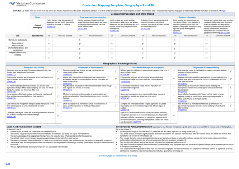
Curriculum Mapping Template: Geography – 9 and 10 Instruction: List the title of the unit of work in the first column and then tick the check box of the content description/s addressed by it, which can be done electronically. Once completed, fill out the ‘Assessments’ table. For detailed notes regarding the purpose of this template and further instructions for completion, refer here Geographical Concepts and Skills Strand Strand Content Description Unit Semester/Year Place, space and interconnection Predict changes in the characteristics of places over time and identify the possible implications of change for the future (VCGGC127) CD Achievement standard # Identify, analyse and explain significant spatial distributions and patterns and identify and evaluate their implications, over time and at different scales (VCGGC128) CD Achievement standard # Data and information Identify, analyse and explain significant interconnections within places and between places over time and at different scales, and evaluate the resulting changes and further consequences (VCGGC129) CD Achievement standard # Collect and record relevant geographical data and information, using ethical protocols, from reliable and useful primary and secondary sources (VCGGC130) CD Achievement standard # Select, organise and represent data and information in different forms, including by constructing special purpose maps that conform to cartographic conventions, using digital and spatial technologies as appropriate (VCGGC131) CD Achievement standard # Analyse and evaluate data, maps and other geographical information using digital and spatial technologies and Geographical Information Systems as appropriate, to develop identifications, descriptions, explanations and conclusions that use geographical terminology (VCGGC132) CD Achievement standard # Biomes and food security Geographies of interconnection Environmental change and management Geographies of human wellbeing Geographical Knowledge Strand Biomes and food security Geographies of interconnection Environmental change and management Geographies of human wellbeing Distribution and characteristics of biomes as regions with distinctive climates, soils, vegetation and productivity (VCGGK133) Perceptions people have of place, and how this influences their connections to different places (VCGGK139) Different types and distribution of environmental changes and the forms it takes in different places (VCGGK144) Interconnecting causes of spatial variations between countries in selected indicators of human wellbeing (VCGGK150) Environmental, economic and technological factors that influence crop yields in Australia and across the world (VCGGK134) Ways in which transportation and information and communication technologies are used to connect people to services, information and people in other places (VCGGK140) Ways that places and people are interconnected with other places through trade in goods and services, at all scales (VCGGK141) Environmental, economic and technological factors that influence environmental change and human responses to its management (VCGGK145) Effects of the production and consumption of goods on places and environments throughout the world and including a country from NorthEast Asia (VCGGK142) Causes and consequences of an environmental change, comparing examples from Australia and at least one other country (VCGGK147) Effects of people’s travel, recreational, cultural or leisure choices on places, and the implications for the future of these places (VCGGK143) Aboriginal and Torres Strait Islander peoples’ approaches to custodial responsibility and environmental management in different regions of Australia (VCGGK148) Application of environmental economic and social criteria in evaluating management responses to an environmental change, and the predicted outcomes and further consequences of management responses on the environment and places, comparing examples from Australia and at least one other country (VCGGK149) Reasons and consequences for spatial variations in human wellbeing on a regional scale within India or another country of the Asia region; and on a local scale in Australia (VCGGK151) Different ways of measuring and mapping human wellbeing and development, and how these can be applied to measure differences between places (VCGGK152) Issues affecting the development of places and their impact on human wellbeing, drawing on a study from a developing country or region in Africa, South America or the Pacific Islands (VCGGK153) Role of initiatives by international and national government and nongovernment organisations to improve human wellbeing in Australia and other countries (VCGGK154) The interconnection between food production and land and water degradation; shortage of fresh water; competing land uses; and climate change, for Australia and other areas of the world (VCGGK135) Human alteration of biomes to produce food, industrial materials and fibres, and the environmental effects of these alterations (VCGGK136) Land and resource management strategies used by Aboriginal or Torres Strait Islander peoples to achieve food security over time (VCGGK137) Challenges in feeding the current and projected populations of Australia and the world, and responses to these challenges (VCGGK138) Environmental worldviews of people and their implications for environmental management (VCGGK146) Levels 7 and 8 Achievement Standard Levels 9 and 10 Achievement Standard- Separated by line. Number in brackets, e.g. (3), can be used as an identifier in various parts of the template. By the end of Level 8 Students explain processes that influence the characteristics of places. They identify, analyse and explain interconnections and spatial characteristics and identity and explain their implications. They compare strategies for a geographical challenge, taking into account a range of factors and predict the likely outcomes. They ethically collect, record and select relevant geographical data and information from useful sources. They select and represent data and information in a range of appropriate forms including maps at different scales that conform to cartographic conventions. They analyse maps and other geographical data and information, and use geographical terminology, to develop identifications, descriptions, explanations and conclusions. They use digital and spatial technologies to represent and analyse data and information. By the end of Level 10 Students predict changes in the characteristics of places over time and identify implications of change for the future. (1) They identify, analyse, and explain significant spatial distributions and patterns and significant interconnections within and between places, and identify and evaluate their implications, over time and at different scales. (2) They evaluate alternative views on a geographical challenge and alternative strategies to address this challenge, using environmental, social and economic criteria, explaining the predicted outcomes and further consequences and drawing a reasoned conclusion. (3) They ethically collect relevant geographical data and information from reliable and useful sources. (4) They select, organise and represent data and information in different forms, using appropriate digital and spatial technologies and through special purpose maps that conform to cartographic conventions. (5) They analyse and evaluate geographical data, maps and information using digital and spatial technologies and Geographical Information Systems as appropriate to develop identifications, descriptions, explanations and conclusions that use geographical terminology. (6) See next page for Assessments and Notes © VCAA Curriculum Mapping Template: Geography – 9 and 10 Notes / Actions Required Assessments Unit (Title) © VCAA Assessment Achievement Standard/s Page 2

