Senguer River Basin Committee
advertisement
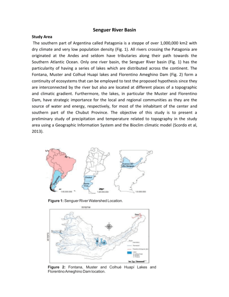
Senguer River Basin Study Area The southern part of Argentina called Patagonia is a steppe of over 1,000,000 km2 with dry climate and very low population density (Fig. 1). All rivers crossing the Patagonia are originated at the Andes and seldom have tributaries along their path towards the Southern Atlantic Ocean. Only one river basin, the Senguer River basin (Fig. 1) has the particularity of having a series of lakes which are distributed across the continent. The Fontana, Muster and Colhué Huapi lakes and Florentino Ameghino Dam (Fig. 2) form a continuity of ecosystems that can be employed to test the proposed hypothesis since they are interconnected by the river but also are located at different places of a topographic and climatic gradient. Furthermore, the lakes, in particular the Muster and Florentino Dam, have strategic importance for the local and regional communities as they are the source of water and energy, respectively, for most of the inhabitant of the center and southern part of the Chubut Province. The objective of this study is to present a preliminary study of precipitation and temperature related to topography in the study area using a Geographic Information System and the Bioclim climatic model (Scordo et al, 2013). Figure 1: Senguer River Watershed Location. Figure 2: Fontana, Muster and Colhué Huapí Lakes and Florentino Ameghino Dam location. Population and main settlements in Senguer river basin Population per department in the Senguer river basin: Escalante department has the greatest population (186,583 inhabitants) and density (13.3 inhab/km²). Comodoro Rivadavia capital of the Chubut province is the main town of the department. Despite not being inside the Senguer River basin this city is of great importance, since most of the consumption water for the basin is use for the inhabitants of this city. The second most populated (11396 people) and population density (0.8 inhab/km²) department is Sarmiento. Moreover Muster and Colhué Huapi lakes where Senguer River concludes are located in this department. Río Senguer department has a population of 5979 and a population density of 0.3 inhab/km². It has a great importance as Lake Fontana is where the Senguer River rises (Table 1 - Figure 3). DEPARTMENT Province POPULATION (inhabitants) Tehuelches Río Senguerr Sarmiento Escalante Florentino Ameghino Lago Buenos Aires Chubut Chubut Chubut Chubut Chubut Santa Cruz 5.390 5.979 11.396 186.583 1.627 8.750 Population Density inhab / km ² 0,4 0,3 0,8 13,3 0,1 0,3 Table 1. Population per department in the Senguer River watershed Source: INDEC, National Census of Population and Housing 2010. Figure 3. Departments and main settlements in Senguer river watershed Source: Shapes and Raster SIG250 Instituto Geográfico Nacional. However, in some cases the population of each department is not representative of the inhabitants living within the basin. To get a better idea of the population inside the basin is better to analyze the main locations inside it: Sarmiento (8,028 inhabitants), Rio Mayo 2971 (people), Alto Río Senguer (1,454 inhabitants) (Figure 4). Economic Activity: Extensive sheep farming in the upper basin and oil development in the lower basin are the most developed economic activities. Both require high water consumption. Other relevant activities in the basin are mining and sawmills. Between Colhué Huapi and Musters lakes is located the Sarmiento department. It is one of the southest world irrigation oasis. Fodder (primarily alfalfa), fruit and vegetables are grown there (Figure 4). Figure 4. Main locations and economic activities in Senguer River Basin. Chubut province Economy Condition No income data are available by departments or location, but at provincial level. In Chubut province 94.5% of the economically active population is employed, and only 5.5% unemployed (Table 2). Other data describing economic condition of the society of each department is available: households with mains water and sewer, gas households, households with refrigerators, households with a computer, etc. Economy Condition Age group Population of 14 years old or more años Población económicamente activa Total Total 14 15-19 20-24 25-29 30-34 35-39 40-44 45-49 50-54 55-59 60-64 65-69 70-74 75-79 80 y más Emplyed Unemployed Population non economically active 373,659 257,985 243,572 14,413 115,674 9,641 44,670 40,950 41,951 42,951 35,631 29,719 28,221 25,095 21,508 17,004 12,781 9,415 6,737 7,385 1,663 15,574 30,890 34,661 36,691 30,647 25,710 24,105 20,711 16,210 10,476 5,448 2,851 1,538 810 1,621 13,251 27,181 32,334 34,955 29,482 24,883 23,369 20,111 15,761 10,194 5,317 2,804 1,507 802 42 2,323 3,709 2,327 1,736 1,165 827 736 600 449 282 131 47 31 8 7,978 29,096 10,060 7,290 6,260 4,984 4,009 4,116 4,384 5,298 6,528 7,333 6,564 5,199 6,575 Table 2. Chubut Province Economy condition Chubut province Illiteratcy Condition Sarmiento and Ecalante departments have a illiteracy rate between 1 and 4% of the total population, while Río Senguer, Florentino Ameghino and Tehuelches, have a rate of between 4.1 and 10% (Figure 3). Figure 3. Chubut province Illiteratcy Condition Source: INDEC, National Census of Population and Housing 2010. Chubut province average water consumption Family consumption (people) - One - Two - Three - Four - Five - Six Source: (Boletín Oficial, 2009) Consumption in liters per day (average) 720 1.100 1.350 1.500 1.800 2.000 Provincial Water Policy Water is a public good and a unique, scarce and vulnerable resource that needs to be properly managed to ensure their protection and proper use. In this regard and in the context of a state policy , a Water Policy that provide unified and integrated management tool where all the stakeholders and decision makers are direct involve, was established by the Chubut Province government(Information of Chubut.gov/IPA). The main objectives of water policy and basic guidelines according to which actions and projects are developed are: 1 - Water resources preservation. Defend and preserve the resource, prevent waste and pollution. 2 - Water resources valuation. Achieve greater efficiency of water use in production. 3 - Resource management democratization. Add all regional actors in the search for consensus defining the PROVINCIAL WATER PROGRAM. This program involves strategic planning to define water resources use. The Basin Committee for each territory is the scope of this interaction. Basin Committees are legal entities entitled to act in the field of public and private law , which are represented municipalities and communes, technical agencies and representatives of all types of users that includes the Water Code ( human consumption , agricultural , cattle , industrial, mining, energy , tourism and medicinal ) . These will be fostered and advised by the Chubut Province Water Institute (IPA). Water resources valuation As part of it management IPA do different works, grouped with the following criteria: - Defense and flood protection - Cleaning, irrigation and drainage network extending works. MODERNIZATION OF IRRIGATION AND DRAINAGE (PROSAP) WORK On draft Modernization and expansion of irrigation networks and drainage Sarmiento Valley, is currently in pre-feasibility report and technical meetings with prospective stakeholders and decision makers and potential channels users. PROSAP - Provincial Agricultural Services Program is going forward with this project estimated to expand 3,400 new hectares , with an investment of nearly 30 million(Information of Chubut.gov/IPA). Democratization Basin committees Chubut government as part of a state policy related to environmental resource has promoted the creation of Basin Committees. These committees serve as instruments for the development of the objectives of the provincial Water Policy: Preservation, Valuation and Democratization . Are locally organized, as delegated authorities for each basin of the province territory that seek to ensure the participation of the municipalities involved in their specific jurisdiction " under Article 4 of the Water Code . As Well all regional stakeholders must be integrated into the water governance. This is done through representation on the Governing Council of a representative from each of the nine types of users recognized by the Water Code, and a representative from the scientific and technological community present in the basin. Since the start of the current administration, necessary actions for the final conformation of such committees across the province have been made . Thus the December 18, 2012, XVIIN Act 13, which ratified the statutes of the Futaleufu River Basin, Chubut River Basin and Senguer River Basin was approved. In continuity with these actions, the conformation of government councils of each Committee was required. Thus, the Governing Councils were formed at the beginning of the 2013: Senguer River Basin Committee: - March 19, the Senguer River Basin Committee governing council was settled in the Constituent Assembly carried out in the Rio Mayo settling. Futaleufu River Basin Committee: - March 26, the Futaleufu River Basin Committee governing council was settled in the Constituent Assembly carried out in the Esquel town. Chubut River Basin Committee: - April 10, the Chubut River Basin Committee governing council was settled in the Constituent Assembly carried out in the El Maitén settling town. Statutes and next committee organization are agreed and awaiting legislative ratification. These are the Puelo River basin, Rio Corcovado basin and Rio Pico basin (Information of Chubut.gov/IPA). Interjurisdictional Basin Committees. Interjurisdictional Basin Committees are currently running for basins shared between Chubut and Río Negro provinces. Those interjurisdictional Basins are COIRCHU for Chubut River Basins, and ACRA for the Azul River Watershed. These Committees operate from interprovincial agreements signed in September 2012. Both COHIRCHU as ACRA, try to the consensus distribution and projection coordinated management of shared waters (Information of Chubut.gov/IPA) . Agreement with municipalities. In order to regulate and manage the extraction of gravel from riverbeds and streams, important agreements with the municipalities of Rio Mayo, Trevelin, The Maitén, Lake Puelo, and others were signed. Considering the large amplitude of the province, IPA was allowed to delegate to municipalities these works especially maintenance (Information of Chubut.gov/IPA). Provincial water court Control the actions of the Basin Committee, and serves as the first court of appeal for the actions taken by the IPA, or the committees in their role as water police are its responsibility. It is conformed by Water Resources Manager and one representative from each Watershed Committee (Information of Chubut.gov/IPA). Institutional Information LAW 5850 - CREATION OF IPA THE LEGISLATURE of the CHUBUT PROVINCE SANCTIONS by Law TITLE I - OBJECT AND POLICY. Section 1-. This Act, in accordance with Article 101 of the Provincial Constitution, is to establish the Provincial Water Policy and strengthen the governance of the water sector in the area of Chubut Province, organizing and regulating government, administration, and unified management tools and comprehensive instruments. All decision makers and stakeholders interested must be involved in the surface and groundwater management (Information of Chubut.gov/IPA). Bibliography: Scordo, F., Ferrelli, F., Piccolo, M.C. y Perillo, G.M.E. 2013. Preliminary Study of argentinian patagonic lakes with GIS and Bioclim. Abstract GLEON (Global Lake Ecological Observatory Network). G-15 4 al 8 de noviembre. Bahía Blanca, Argentina. Pp 28-29. Webpage: http://www.gleonrcn.org/media/G15PosterAbstracts.pdf http://www.indec.mecon.ar/ https://2mp.conae.gov.ar/index.php/materialeseducativos/coberturasvectoriales/522-sig-250-delinstituto-geografico-nacional http://organismos.chubut.gov.ar/ipa/ Boletín Oficial de la Provincia de Chubut; Jueves 22 de http://www.chubut.gov.ar/boletin/archives/pdf/Enero%2022,%202009.pdf Enero de 2009;

![Georgina Basin Factsheet [DOCX 1.4mb]](http://s3.studylib.net/store/data/006607361_1-8840af865700fceb4b28253415797ba7-300x300.png)
