Landowner Assistance Program
advertisement
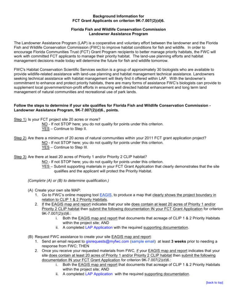
Background Information for FCT Grant Applicants on criterion 9K-7.007(2)(d)6. Florida Fish and Wildlife Conservation Commission Landowner Assistance Program The Landowner Assistance Program (LAP) is a cooperative and voluntary effort between the landowner and the Florida Fish and Wildlife Conservation Commission (FWC) to improve habitat conditions for fish and wildlife. In order to encourage Florida Communities Trust (FCT) Grant Program recipients to better manage priority habitats, the FWC will work with committed FCT applicants to manage their priority habitat. The land-use planning efforts and habitat management decisions made today will determine the future for fish and wildlife tomorrow. FWC's Habitat Conservation Scientific Services section is a group of approximately 30 biologists who are available to provide wildlife-related assistance with land-use planning and habitat management technical assistance. Landowners seeking technical assistance with habitat management will likely find it offered within LAP. With the landowner’s commitment to enhance and protect priority habitats, there are many forms of assistance FWC’s biologists can provide to supplement local government/non-profit efforts in ensuring well directed habitat enhancement and long term land management of natural communities and recreational use of park lands. Follow the steps to determine if your site qualifies for Florida Fish and Wildlife Conservation Commission Landowner Assistance Program, 9K-7.007(2)(d)6., points. Step 1) Is your FCT project site 20 acres or more? NO - If not STOP here; you do not quality for points under this criterion. YES – Continue to Step II. Step 2) Are there a minimum of 20 acres of natural communities within your 2011 FCT grant application project? NO - If not STOP here; you do not quality for points under this criterion. YES – Continue to Step III. Step 3) Are there at least 20 acres of Priority 1 and/or Priority 2 CLIP habitat? NO - If not STOP here; you do not quality for points under this criterion. YES – Submit supporting materials in your FCT Grant Application that clearly demonstrates that the site qualifies and the applicant will protect the Priority Habitat. (Complete (A) or (B) to determine qualification.) (A) Create your own site MAP: 1. Go to FWC’s online mapping tool EAGIS, to produce a map that clearly shows the project boundary in relation to CLIP 1 & 2 Priority Habitats. 2. If the EAGIS map and report indicates that your site does contain at least 20 acres of Priority 1 and/or Priority 2 CLIP habitat then submit the following documentation IN your FCT Grant Application for criterion 9K-7.007(2)(d)6.: i. Both the EAGIS map and report that documents that acreage of CLIP 1 & 2 Priority Habitats within the project site; AND ii. A completed LAP Application with the required supporting documentation. (B) Request FWC assistance to create your site EAGIS map and report: 1. Send an email request to gisrequests@myfwc.com (sample email) at least 3 weeks prior to needing a response from FWC; THEN 2. Once you receive your requested materials from FWC, if your EAGIS map and report indicates that your site does contain at least 20 acres of Priority 1 and/or Priority 2 CLIP habitat then submit the following documentation IN your FCT Grant Application for criterion 9K-7.007(2)(d)6.: i. Both the EAGIS map and report that documents that acreage of CLIP 1 & 2 Priority Habitats within the project site; AND ii. A completed LAP Application with the required supporting documentation. [back to top] Example email request to gisrequests@myfwc.com To: gisrequests@myfwc.com From: (applicant name and email) Subject: EAGIS request for CLIP 1 & 2 Priority Habitats Map & Report FCT Grant Application Attachments: FCT Project Site Boundary Please provide the following information so we may include the FWC’s Landowner Assistance Program criterion in our 2011 Florida Communities Trust (FCT) Grant Application. Please send us an email response with: An EAGIS Map and Report that documents the acreage of CLIP 1 & 2 Priority Habitats within the FCT Project Site; Please find the attached documentation on project site boundary: Boundary Map(s) :(include either a shape file, property appraisers map or other acceptable detailed project boundary) Please Note: We tried to using EAGIS to gather this information but encountered difficulty for the following reasons: (Optional but preferred: please provide any feedback here that will help improve the future usability of EAGIS) Signed- (Requestor Name & Phone number etc) [back to top] Landowner Assistance Program Application for Florida Communities Trust 2011 Grant Applicants The goal of the Landowner Assistance Program (LAP) for FCT grants is to assist the proposed landowner with enhancement of habitat conditions for fish and wildlife that lead to long term conservation partnership with landowners. Enrollment in the LAP indicates the applicant’s approval for documentation of wildlife species occurrences on enrolled properties and that the applicant will consider FWC’s recommendations regarding the management of the project site if acquired with the assistance of FCT. Project Site information: Does a current habitat-management plan exist for the site? ______Yes ______No Key Contact Last Name: _____________________________________First Name: _________________________________MI:____ (This must be the same person designated in the FCT Grant Application.) Title: ____________________________________________________________________________________________ Local Gov’t/Nonprofit Environmental Organization: ________________________________________________________ Mailing Address: ___________________________________________________________________________________ City ___________________________________________________, FL Zip Code ______________________________ Phone Number _____________________________ E-mail Address __________________________________________ Enrolled Project Site information: Total FCT Project Site Acres: ___________; Estimated Acres Enrolled in LAP: __________________________________ (This should equal the Priority 1/Priority 2 Habitat acres within Project Site.) Section(s) _________________; Township ________________North or South; Range ________________ East or West County:____________________; Current land use of enrolled acres:__________________________________________ To your knowledge: Is the property currently managed with using any Cost-Share Programs?_____Yes _____No; List:__________________ Is the property enrolled in the RCW Safe Harbor Program? ______Yes ______No Is the property a “Certified” Gopher Tortoise Recipient Site? ______Yes ______No Supporting Documentation: must include the following documentation with the application to be considered: _______Copy of the FWC EAGIS Priority 1 and/or 2 Habitat Map _______Copy of the FWC EAGIS Priority 1 and/or 2 Habitat Report Key Contact Signature:_______________________________________________ Date:_____________________ NOTE: Submit this page & all required supporting documentation with the FCT grant application for consideration of criterion 9K-7.007(2)(d)6. Please visit Florida’s Wildlife Conservation Guide to develop your own management strategies for restoration and conservation within this project area and on other managed lands using. [back to top]
