GEOG P1 - M.S
advertisement
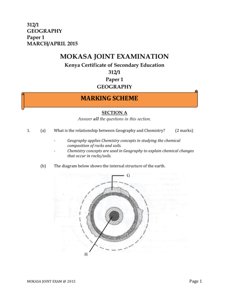
312/1 GEOGRAPHY Paper 1 MARCH/APRIL 2015 MOKASA JOINT EXAMINATION Kenya Certificate of Secondary Education 312/1 Paper 1 GEOGRAPHY MARKING SCHEME SECTION A Answer all the questions in this section. 1. (a) What is the relationship between Geography and Chemistry? - (b) (2 marks) Geography applies Chemistry concepts in studying the chemical composition of rocks and soils. Chemistry concepts are used in Geography to explain chemical changes that occur in rocks/soils. The diagram below shows the internal structure of the earth. G H MOKASA JOINT EXAM @ 2015 Page 1 (i) Name the parts marked G and H. G H (ii) (a) Olivine/ ferromagnesian silicate (2 marks) Absolute humidity is the actual amount of water vapour or moisture in a given mass of air at a particular temperature while relative humidity is the ratio of the absolute humidity of a given mass of air to the maximum amount of moisture that this mass of air could hold at the same temperature. State the significance of humidity in the atmosphere. - 3. (1 mark) Differentiate between absolute and relative humidity. - (b) Continental crust/sial Inner core Name the dominant mineral in the mantle. - 2. - (2 marks) (3 marks) The amount of water vapour in a given volume of air indicates the atmospheres potential capacity to hold moisture: It determines the amount of precipitation that a given area is likely to receive. Water vapour is important in absorbing radiation hence regulates the heat loss from the earth. The amount of water vapour determines the amount of energy stored in the atmosphere for the development of storms. The diagram below shows some features formed by faulting. Y (2 marks) heave upthrow throw downthrow X (a) Name the parts marked X and Y. X Y - MOKASA JOINT EXAM @ 2015 (2 marks) Hade Fault scarp/escarpment/scarp face. Page 2 (b) State three effects of faulting on drainage of an area. - 4. (a) (a) - - (2 marks) Plant roots grow into the joints and cracks of rocks widening the joints and cracks and with time they cause rock blocks to separate and break away. The widening of joints and cracks provide space and passage for moisture and air to penetrate deeper into the rocks facilitating hydrolysis and solution weathering process. Plants rot on rocks in the presence of moisture producing organic acids which react with some of minerals within the rock causing it to decay. Mosses and Lichens that grow on a rock cause the rock to be moist, facilitating chemical weathering process to take place. Describe the process of weathering through oxidation. - (3 marks) The mid-Atlantic The Great Rift Valley region The Mediterranean region/Tethyan The circum Pacific region West coast of South America/ the Andes region West coast of N. America/Rockies region Himalayas belt State two ways in which plants cause weathering. - (b) Rossi forell scale Mercalli scale Give three major earthquake zones of the world. - 5. Down warping due to faulting may lead to formation of depressions which may be filled by water to form lakes. Fault lines due to fracturing of crustal rocks may change the course of river making the river to start flowing a long the fault line forming faulting guided drainage pattern. Fault scarps forming across rivers course may lead to formation of waterfalls. Faulting may lead to formation of lines of weakness in earth’s crust which becomes passages for hot water from the underground to the earth’s surface to form hot springs and geysers. Identify two scales used to measure the intensity of an earthquake.(2 marks) - (b) (3 marks) (3 marks) Rocks with iron mineral combined with oxygen/ oxidized to form a new mineral. The new rock formed easily crumbles. Ferrous oxide is oxidized to ferric oxide which is reddish brown in colour which easily crumbles. MOKASA JOINT EXAM @ 2015 Page 3 SECTION B Answer question 6 and any other TWO questions from this section. 6. Study the map of Migwani 1:50,000 (sheet 151/1) provided and answer the following questions. (a) (i) What is the altitude of the lowest contour shown on the map? (1 mark) 660m (ii) Give the six-figure grid reference of Mboni dam. - (iii) (b) (2 marks) 073784 What is the length in Kilometres of the All Weather Road Bound Surface C94 from the junction with the Dry Weather Road D502 to Northing 84? (2 marks) 5.6 km Draw a rectangle measuring 10 cm by 8 cm to represent the area enclosed by Eastings 90 and 00 and Northings 62 and 70. (1 mark) ROAD E742 MUSENGO SCHOOL KITUI HILLS On the rectangle, mark and name the following features: (i) (ii) (iii) Musengo school Road E742 Kitui Hills MOKASA JOINT EXAM @ 2015 (3 marks) Page 4 (c) (i) Citing evidence from the map, identify four social services offered in Mutitu (Ndooa) township. (4 marks) Services - Health/medical services - Administration services - Water supply services - Education services - Housing services (ii) Describe the relief of the area covered by the map. - - Describe the characteristics of the long profile of river Ikoo. - 7. (a) (6 marks) The lowest altitude is 660m/ the highest altitude is 1515m above sea level. The land rises from the East to the West. To the east of Easting 08, the landscape is generally hilly/has many hills. There are many interlocking spurs along river valleys There are some abroad valleys in the South East. The landscape is dissected by river valleys. There are many narrow river valleys in the highlands. The land is gently sloping in the east. There are steep slopes in the hilly areas/ to the West. Some areas in the east are flat. There are ridges in the central and South Western part. - (d) Evidence - Health centre - Court house/Chief’s office - Pipeline/water tank - School - Built up area/huts (6 marks) - River Ikoo flows to the South East. The river has many meanders The river becomes wider from grid square 0769. There are interlocking spurs along the course of the river. The river has many small tributaries that form a dendritic pattern along the course. Some parts of the long profile have a steep gradient. There are sand/mud deposits downstream The river is permanent. (i) Describe the following characteristics of minerals: Texture (1 mark) MOKASA JOINT EXAM @ 2015 The sizes and shapes of individual mineral particles vary/differs. Tenacity (1 mark) The ability of a mineral to resist/to withstand tearing, crushing or breaking differs/vary. Page 5 (ii) Describe how extrusive igneous rocks are formed. - (b) (c) During volacanic eruptions, lava and other volcanic materials thrown on to the earth’s surface. The lava cools and solidify to form extrusive/volcanic igneous rocks. The rate of cooling and solidification is very rapid due to presence of low temperature such that the rocks formed will have minerals with fine textured and small crystals. (b) For each of the following rocks, name the resultant rock that forms after metamorphism. (i) Sandstone - Quartzite (1 mark) (ii) Limestone - Marble (1 mark) (iii) Granite - Gneiss (1 mark) Explain three economic significance of rocks in Kenya. - (d) (4 marks) (3 marks) Some rocks such as granite, volcanic peaks may form unique sceneries which attract tourists promoting tourism industry. Rocks provide the parent materials through weathered rocks especially volcanic rocks forming fertile volcanic soils for agricultural production. Rocks such as sandstone, marble and limestone are strong and resistant to weathering are used in the building and construction industry. Minerals and other valuables substances are extracted/mined. Some rocks are used as raw materials for the manufacturing industry. Impermiable rocks may act as storage of underground water which can be tapped to supply water for domestic and industrial use. Students carried out a field study on rocks around their school. (i) State two importance of stating the objectives for the study. (2 marks) They direct the actual activities to be carried out during the study. They guide the possible areas of data collection to obtain required information. They give the aims/purposes for carrying out the field study. They guide on the appropriate methods/tools for data collection. (ii) Give three reasons why they prepared a route map of the study area. (3 marks) - MOKASA JOINT EXAM @ 2015 To identify direction they would take To show the features/rocks they are likely to see. To help estimate the distance to be carried To help estimate the time to be taken. To help make/prepare time schedule. Page 6 (iii) Give three activities that the students where involved in during the field study. (3 marks) - 8. (a) (i) What is an orogeny? - (ii) (2 marks) A fold mountain building period. Give two factors that influence the folding process of rocks. (2 marks) - (b) Data collection/taking photographs/filming/videoing Data recording/ taking notes/tallying/sketching Collecting different types of rock samples. Classifying collected rock samples Labeling of collected rock samples. The strength/intensity/magnitude of the compressional forces. The nature of the sedimentary rocks/The age of the rocks The diagram below shows some types of folds. Use it to answer the question (i) and (ii). F (i) Name the types of folds marked E and F. E F (ii) - - MOKASA JOINT EXAM @ 2015 (2 marks) Overfold Recumbent fold Describe how an overthrust fold is formed. - Nappe fold (4 marks) Layers of rocks of the earths crust are subjected to compressional forces. Intense folding result in the formation of an overfold. With increased pressure, the overfold results in the formation of recumbent fold producing a thrust plane. Page 7 - (c) Name the countries in which the following fold mountains are found. (i) Atlas - (ii) (iii) Austria/ Switzerland/ Italy/ France/ Leichstein. (1 mark) India/Pakistan/Afghanistan/ Bhutan/ Nepal/ China. (1 mark) Chile/ Peru/ Bolivia/ Argentina/ Venezuela/ Ecuador/ Colombia Apart from fold mountains, name three other features resulting from folding. (3 marks) - (ii) (1 mark) Andes - (i) Western Sahara/ Morocco/ Algeria Himalayas - (iv) (1 mark) Alps - (d) The upper part of the recumbent fold slides forward over the lower part along the fault plane resulting to the formation of an overthrust fold. Synclinal valleys/depressions Rolling plains Ridges Intermontane basins Intermontane plateaus Explain four ways in which fold mountains influence climate. (8 marks) The slopes of mountains which face the sun receive direct sunshine /and are warmer. Mountain slopes cause the development of local winds due to variation in pressure between the mountain top and the valley bottom. The windward slopes of mountains receive high rainfall due to orographic effect. Atmospheric pressure reduces with increasing attitude along a mountain slope. Temperature decreases with increasing /altitude along a mountain slope. MOKASA JOINT EXAM @ 2015 Page 8 9. (a) (i) Differentiate between a marine delta and a Lacustrine delta. (2 marks) Marine delta is formed when a river deposits its load as it enters the sea while lucustrine is formed as a river enters a lake. (ii) Explain three conditions necessary for the formation of a delta. (6 marks) The river must have a large load of sediments as it drains into the sea/lake The river course must be free from obstacles which may interfere with rivers load/which may reduce the amount of load/filtering the amount of load. The gradient of the river at its mouth be low to allow slow flow of the river. The sediments must be deposited at a faster rate then they are removed by ocean currents at the river mouths. (iii) State three significance of deltas to man. - (b) (i) (ii) Alluvial deposits in deltas may have valuable minerals which are then exploited. Deltas have forms extensive natural vegetation which support variety of wildlife/ ecosystem Alluvial deposits forms extensive land settlement/agriculture. What is a braided channel? - (3 marks) (2 marks) It’s a wide and shallow channel of a river made up of network of diverging minor channels separated from each other by sand banks. State four conditions necessary for the formation of a braided channel. (4 marks) A river must carry a large load The section where braids form should have a reduced gradient A dry season when the volume of water coming from catchment area is reduced. Arid conditions which encourage evaporation reducing volume of water. Presence of an obstacle/sand banks may cause the river to subdivide into many channels MOKASA JOINT EXAM @ 2015 Page 9 (c) With the aid of well labelled diagrams, describe how an ox-bow lake is formed. (8 marks) Alluvial deposits Alluvial deposits Ox-bow lake - An ox-bow lake forms when a river starts to meander on a flood plain. Lateral erosion dominates on the outer side of the bend while deposition takes place on the inner bank. MOKASA JOINT EXAM @ 2015 Page 10 10. (a) Lateral erosion results in the reduction of the neck of the land between adjacent bends. The neck of land is eventually worn away. Deposition on the meander sides especially during flood blocks off the meander. The river abandons the meander and follows the new…… cut that was the neck of the land. What is Karst scenery? - (2 marks) A landscape dominated by limestone, chalk or dolomite rocks which are soluble in rain water through carbonation to form unique features. (b) State four factors which influence the development of a karst landsforms. (4 marks) Presence of hard and well-jointed limestone, chalk or dolomite rocks for maximum water permeability. Hot and humid climate /abundant rainfall to increase rate of solution. Water table should be below/deep the earth’s surface to allow more water percolating down the rocks cracks enhancing formation of features. Long period of time the area has been subjected to weathering and erosion processes. (c) The diagram below shows a feature in a Karst landscape. Use it to answer question (i) and (ii). Y Z X (i) Name the parts marked X, Y and Z. X Y Z (ii) - Limestone rock/chalk/dolomite Clint Grike Describe how the features marked Y and Z are formed. - MOKASA JOINT EXAM @ 2015 (3 marks) (5 marks) Weathering opens up rock joints in limestone areas. Rain water through carbonation further widens the limestone joints and dissolves the soluble part of the limestone to form narrow and deep depressions called grikes. The more resistant parts will remain raised blocks above the grikes and called clints. Page 11 (d) (i) Define a lake. - (2 marks) It is a large/body mass of water occupying a basin/ depression/ hollow on the earth’s surface. (ii) Name two types of lakes which are formed by volcanic activity. (2 marks) Crater lakes Lava-dammed lakes (iii) State three reasons why some lakes are salty. - - (iv) (3 marks) Some lakes lack fresh water inlets emptying into such lakes making them saline. Some lakes have underground inlets having high concentration of salts making them saline. Some rivers flowing into these lakes flows over rocks containing high salt contents which are dissolved by river water and draining into such lakes making them saline. Many lakes do not have outlets to drain away excess salts leading to accumulation of salts in these lakes making them saline. Some lakes are formed in arid and semi-arid areas having high temperatures causing high evaporation from these lakes increasing the accumulation and concentration of dissolved minerals salts making them saline. Most lakes have their underlying rock basement containing lots of minerals salts which may be dissolved directly by the lake waters making them saline. Explain four ways in which lakes are of significance to human activities. (4 marks) - MOKASA JOINT EXAM @ 2015 Some lakes forms major inland fishing grounds providing fish as source of animal protein. Fresh water lakes are source of fresh water for domestic/industrial use. Some lakes may contain minerals such as trona which is exploited/some lakes may contain minerals used as raw materials in industries. Man-made lakes are used as reservoirs for production of hydroelectric power providing energy for domestic/industrial uses. Sand deposit along the shores of some lakes are harvested and used as building and construction materials. Some lakes provide cheap means of water transport for people/ goods promoting trade. Page 12


