GEOGRAPHY PRE-TEST
advertisement
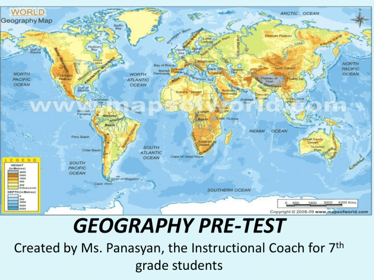
GEOGRAPHY PRE-TEST Created by Ms. Panasyan, the Instructional Coach for 7th grade students Why do I need to study Geography? 1. Any natural feature on the Earth surface, such as a mountain, hill, plateau, or plain is called… a. b. c. d. Continent Landform Feature Legend 2. What is precipitation? a. The amount of pressure in atmosphere b. Level of water in reservoir c. Water pressure d. Water in the form of rain, snow, or hail 3. 0 degrees of longitude is called…. A. the Prime Meridian B. The International Date Line C. The Equator D. The North Pole 4. O degrees of latitude is called A. the Prime Meridian B. The International Date Line C. The Equator D. The North Pole 5.On most maps, the top of the map usually represents which direction? A. North B. South C. East D. West 6.Most of the Earth’s surface is covered by… A. land B. forest C. water D. desert 7. The Northern and Southern Hemispheres are divided by what line? A. The International Date Line B. The Equator C. The Line of Control D. The Prime Meridian 8. Which city does the Prime Meridian pass through? A. New York B. Greenwich C. Buenos Aires D. London 9.Which river runs north to south across the United States? A. The Jordan B. The Euphrates C. The Missouri D. The Mississippi 10.What body of water does that river empty into? A. The Atlantic Ocean B. The Gulf of Mexico C. The Pacific Ocean D. The Adriatic Sea 11. Which mountain range is the longest in the world? A. The Rocky Mountains B. The Himalayans C. The Andes D. Sierra Nevada Mountain 12. Which mountain range is the highest in the world? A. B. C. D. The Himalayans The Appalachians The Urals The Andes 13. Which mountains divide Europe from Asia? A. The Sierra Nevada Mountains B. The Turkish Mountains C. The Himalayans D. The Urals 14. Cape Horn is the most southern point of which continent? A. B. C. D. Europe Asia South America Africa 15. Which continent is the largest? A. B. C. D. Asia North America South America Australia 16. Which continent is the smallest? A. B. C. D. Antarctica Asia Africa Australia 17.The Eastern and Western Hemispheres are divided by what line? A. The Equator B. The Prime Meridian C. The International Date Line D. The Middle Line 18.What can be found at 90 degrees latitude? A. B. C. D. The North Pole Helsinki, Finland Anchorage, Alaska Really good skiing For numbers 19-25 read each statement carefully. Write T if the statement is true and F if the statement is false 19. Latitude and longitude lines are measured in degrees, minutes, and seconds_________ 20. Latitude refers to a distance away from the Equator__________ 21. A continent is a small landform surrounded by water__________ 22. The International Date Line is at 180 degrees longitude_____ Continue… 23. The parallel lines running north to south on a globe are called lines of latitude_____ 24. The parallel lines running north to south on a globe are called lines of longitude_____ 25.The Pacific Ocean is the largest ocean______ For numbers 26-30 write a short answer to the questions 26. Write a definition for the term “Geography” 27. What are four cardinal directions? 28. List seven continents on the planet Earth 29. Name the countries that physically border the United States of America 30. How many states does United States of America has as of today? Now, let’s check the answers: • Switch your pre-test with your partner. • Write your name at the bottom of the paper: “corrected by…” • If the answer is correct – leave it as is. • If the answer is wrong— cross out the letter. 1. Any natural feature on the Earth surface, such as a mountain, hill, plateau, or plain is called… a. b. c. d. Continent Landform Feature Legend 2. What is precipitation? a. The amount of pressure in atmosphere b. Level of water in reservoir c. Water pressure d. Water in the form of rain, snow, or hail 3. 0 degrees of longitude is called…. • A. the Prime Meridian • B. The International Date Line • C. The Equator • D. The North Pole 4. O degrees of latitude is called A. the Prime Meridian B. The International Date Line C. The Equator D. The North Pole 5.On most maps, the top of the map usually represents which direction? A. North B. South C. East D. West 6.Most of the Earth’s surface is covered by… A. land B. forest C. water D. desert 7. The Northern and Southern Hemispheres are divided by what line? A. The International Date Line B. The Equator C. The Line of Control D. The Prime Meridian 8. Which city does the Prime Meridian pass through? Greenwich A. New York B. Greenwich C. Buenos Aires D. London 9.Which river runs north to south across the United States? A. The Jordan B. The Euphrates C. The Missouri D. The Mississippi 10.What body of water does that river empty into? A. The Atlantic Ocean B. The Gulf of Mexico C. The Pacific Ocean D. The Adriatic Sea 11. Which mountain range is the longest in the world? A. The Rocky Mountains B. The Himalayans C. The Andes D. Sierra Nevada Mountain 12. Which mountain range is the highest in the world? A. B. C. D. The Himalayans The Appalachians The Urals The Andes 13. Which mountains divide Europe from Asia? A. The Sierra Nevada Mountains B. The Turkish Mountains C. The Himalayans D. The Urals 14. Cape Horn is the most southern point of which continent? A. B. C. D. Europe Asia South America Africa 15. Which continent is the largest? A. B. C. D. Asia North America South America Australia 16. Which continent is the smallest? A. B. C. D. Antarctica Asia Africa Australia 17.The Eastern and Western Hemispheres are divided by what line? • A. The Equator • B. The Prime Meridian • C. The International Date Line • D. The Middle Line 18.What can be found at 90 degrees latitude? A. B. C. D. The North Pole Helsinki, Finland Anchorage, Alaska Really good skiing For numbers 19-25 read each statement carefully. Write T if the statement is true and F if the statement is false 19. Latitude and longitude lines are measured in degrees, minutes, and seconds__T 20. Latitude refers to a distance away from the Equator_____T 21. A continent is a small landform surrounded by water___F 22. The International Date Line is at 180 degrees longitude__T Continue… 23. The parallel lines running north to south on a globe are called lines of latitude_T 24. The parallel lines running north to south on a globe are called lines of longitude_F 25.The Pacific Ocean is the largest ocean__T For numbers 26-30 write a short answer to the questions 26. Write a definition for the term “Geography” Geography is a study of Earth 27. What are four cardinal directions? North, South, East, West. 28. List seven continents on the planet Earth N. America ,S. America, Africa, Europe, Asia, Antarctica, Australia 29. Name the countries that physically border the United States of America Canada & Mexico 30. How many states does United States of America has as of today? 50


