Airmasses and Fronts
advertisement
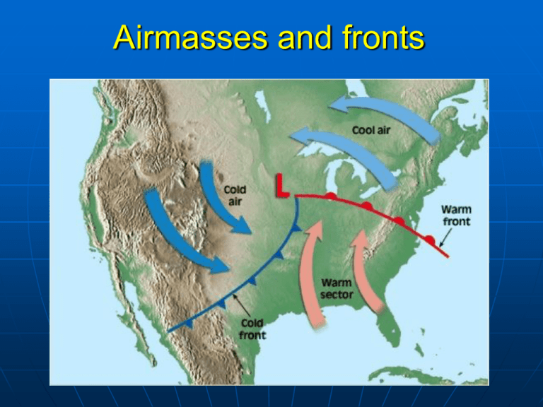
Airmasses and fronts Review of last lecture Tropical cyclone structure: 3 major components, rotation direction of inflow and outflow, location of maximum wind and rainfall, 3 feedbacks Tropical cyclone destruction: 4 reasons? Which side has the most intense destruction? Tropical cyclone forecast: track and intensity Currently which skill is better? Air masses An airmass is a large (usually thousands of km across) volume of air that has horizontally uniform properties of temperature and moisture. Airmasses acquire their properties from spending days to weeks over the same part of the Earth. “Polar” airmasses are colder than “tropical” airmasses “Maritime” airmasses are wetter than "continental" airmass Other specific airmass types include "arctic", "equatorial", and “monsoon” Bergeron classification of air masses 3 letters: e.g. mTk, cPw 1st letter for moisture properties: c - continental, m - maritime 2nd letter for thermal characteristics: T - tropical, P -polar, A Artitic/Antarctic, M - monsoon, E - equatorial, S -superior air(dry air formed by significant downward motion in the atmosphere) 3rd letter for stability: k/w - air colder/warmer than ground Source regions The areas where air masses form are called source regions. Surface weather analysis is a special type of weather map summarizing the information from all weather stations. Wind speed code 5 10 50 Present weather Type Intensity Video: Weather fronts http://www.youtube.com/watch?v=tkK4 _F0VKhM Fronts A weather front is a boundary separating two air masses Types: cold front, warm front, occluded front, stationary front, dry line, squall line Cold Fronts • A cold front is a mass of cold air advancing towards warm air. • Typically associated with heavy precipitation, rain or snow, combined with rapid temperature drops. • Since friction decreases with height, winds move faster at higher altitude. Then the surface of cold front becomes more steeper through time, leading to a narrow belt of precipitation. • Moving speed 0-30mph Satellite and radar images of cold fronts (narrow belt of clouds/precipitation) Warm Fronts • Warm fronts are warm air moving towards cold air. • This overrunning process produces large amounts of warm, moist air over cooler, drier air. • Shallow stratus clouds dominate and bring light precipitation to affected regions. Stable regions above the warmer air create vertically limited clouds and light precipitation. Frontal fogs may occur as rain evaporates in the colder air near the surface. • Moving speed about 12 mph Slope of warm Fronts • Friction decreases with height, so winds move faster at higher altitude • This causes the surface of the front to become less steep through time. Then clouds will be spread to a wider region. Satellite and radar images of warm fronts (wide region of clouds/precipitation) Stationary Fronts • Stationary fronts do not move. They do not advance. They are two unlike air masses side by side. • They may slowly migrate and warmer air is displaced above colder. From Environment Canada Occluded Fronts • Occluded fronts occur when two fronts meet, the warm air mass between them is displaced aloft. • This typically occurs when a cold front meets a warm front as it circulates the low pressure center of a mid-latitude cyclone. • The cold and warm fronts curve naturally poleward into the point of occlusion, which is also known as the triple point. Formation of Occluded Fronts Different types of occluded fronts • A cold-type occlusion usually occurs in the eastern half of the continent where a cold front associated with continental/Polar air meets a warm front with maritime/Polar air ahead. • A warm-type occlusion is typical of the western edges of continents where the cold front, associated with maritime/Polar air, migrates to an area that is occupied by continental/Polar air. Drylines • Drylines are boundaries between lighter humid air and denser dry air. • Air masses with similar temperatures but strong humidity gradients will act as fronts. • They frequently occur throughout the Great Plains, and are a favored location for thunderstorm development. Summary 1. Definition of airmasses. Bergeron classification of air masses (3 letters) 2. Surface weather analysis: Station model, wind speed code, present weather 3. Fronts: 6 types. 4. What is a cold front? Steep, narrow, fast 5. What is a warm front? Less steep, wide, slow 6. What is an occluded front? Two types

