Air masses and fronts
advertisement
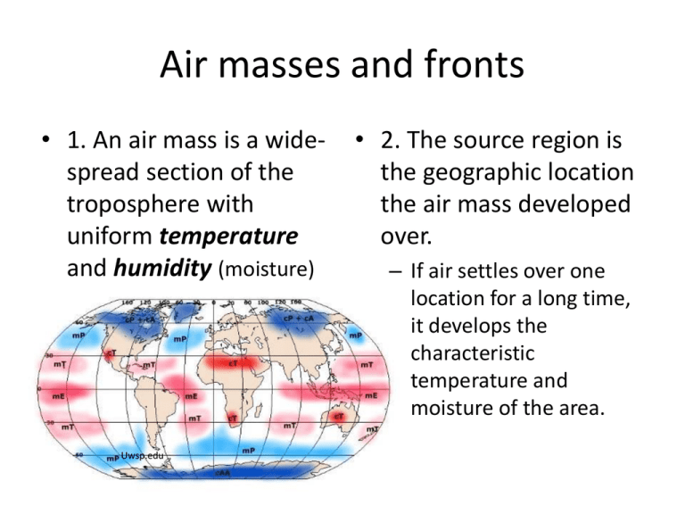
Air masses and fronts • 1. An air mass is a widespread section of the troposphere with uniform temperature and humidity (moisture) Uwsp.edu • 2. The source region is the geographic location the air mass developed over. – If air settles over one location for a long time, it develops the characteristic temperature and moisture of the area. • Because temperature changes so much with latitude, tropical areas are warm and polar are cold. • Oceans (maritime) carry a lot of water vapor • On land, (continental) there is little water and the air is dry. blueollie.wordpress.com Page 13 ESRT uses symbols for the air masses • Dry air is small ‘cf’ or continental • Moist air is small ‘m’ for maritime • Cold air is ‘P’ for Polar and REALLY cold air is ‘A’ for arctic. • Warm air is ‘T’ for tropical Geography.hunter.cuny.edu And to practice: • 1. Bringing those two characteristics together, the air masses may be described. For the following, identify the characteristics: cT: mT: cP: mP: cA: • 2. The characteristics of the air mass is due to the __________________ region, or area where it formed. For each of the following locations create our ______ _________ (and weather), identify the characteristics of the air, using the terms continental, maritime, tropical, arctic and polar. Gulf of Mexico: Central Mexico: Great Plains (winter): Central Canada: Northern Atlantic: Review book Chapter 8 pages 199-200 Air masses and polar fronts: http://www.classzone.com/books/earth_science/terc/navigation/chapter20.cfm https://castlelearning.com/review/login/login.aspx for air masses Fronts: the boundary between two air masses • A boundary describes where two different things meet. Between countries Between lawns Between air and land. A frontal boundary is where two different air masses meet. Energy is exchanged. • Fronts bring a change in weather. • One type of air mass pushes in and replaces another one. • “Bad weather” (storms and precipitation) occurs at fronts. • How severe the storm is depends on: – how quick the change is – The differences between the 2 air masses: • a REALLY warm, moist air mass meeting a REALLY cold, dry air mass will produce dramatic weather/storm. – How much moisture is in the warm air mass. weather.thefuntimesguide.com The type of front created depends on the direction the air masses move and the way the air masses meet. • Page 13 of ESRT lists 4 types of front and symbols • In the US, our weather systems tends to move from west to east. • The winds in a storm, tend to make a counterclockwise rotation. scoutweatherbadge.wordpress.com Cold Fronts • Side view: physicalgeography.net geography.hunter.cuny.edu Cold front overview – Cold front, in which heavy cold air replaces light, warm air . – The effect is tall, dramatic cumulonimbus clouds, lots of wind, and brief and intense precipitation. (hail, tstorms and even tornadoes) • Clouds form at fronts because warm, moist air is pushed up at the boundary by the heavier, colder air mass. • Clouds form as rising air cools to the dew point temperature and water vapor condenses around condensation nuclei, such as soot or ash. • Precipitation happens at the front http://www.nc-climate.ncsu.edu/edu/k12/fronts/body explore.ecb.org Warm front: side view nauticed.org http://www.ux1.eiu.edu/~cfjps/1400/fronts.html Warm front: map overview gcel.com.mx – Warm front, in which warmer air replaces colder air. The effect is cirrus and stratus clouds, steady precipitation that may last for a day or two. – Usually, the warm air has more moisture. – The warm air is pushed up at the frontal boundary, causing clouds to form. • The wedge-shape front is caused by the warm air slowly pushing up along the boundary. • Precipitation happens ahead of the front. http://elearning.stkc.go.th/lms/html/earth_science/LOcanada7/706/3_en.ht m http://www.nc-climate.ncsu.edu/edu/k12/fronts/body Occluded front: side view physicalgeography.net aos.wisc.edu allposters.com – Occluded front, in which a cold air mass wraps around a warm air mass, actually lifting the air off the ground. – This causes a REALLY dramatic change in weather, intense winds and violent precipitation. (Noreasters, some tornadoes and t-storms) Overview muhs.acsu.k12.vt.us http://www.fas.org/irp/imint/docs/rst/Sect14/Sect14_1d.html Stationary front lewistonpublicschools.org http://www.nc-climate.ncsu.edu/edu/k12/fronts/body http://www.windows2universe.org/earth/Atmosphere/html • Stationary fronts may last for days because the 2 air masses just don’t really move. Usually, the characteristics are similar to the warm front, just prolonged. • Again, it is the warmer air that is pushed up because it is less dense. • Why clouds??? • Rising air expands and COOLS. • Water vapor CONDENSES. http://www.geog.ucsb.edu/~joel/g110_w08/lecture_notes/midlat_surface/ midlat_surface.html Previous page: Polar front development • Review book chapter 8 pages 200-203 and questions 14-21. • http://www.classzone.com/books/ earth_science/terc/navigation/cha pter20.cfm • https://castlelearning.com/review/ login/login.aspx for fronts
