453 Case Study: Feb 5-6, 2008 Super Tuesday Outbreak
advertisement
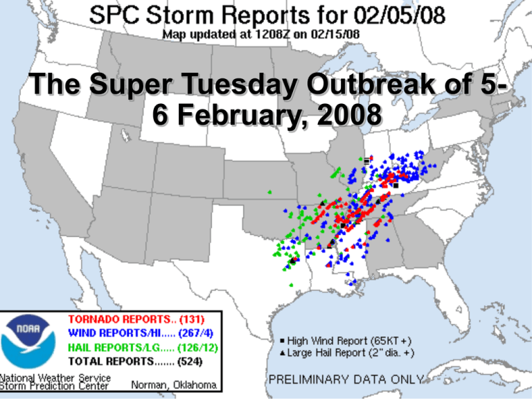
The Super Tuesday Outbreak of 56 February, 2008 Hypothesis Upper-level trough in the Plains Shortwave passing through Low-level jet from Gulf of Mexico Moisture advection from south Strong, veering winds Neutral layer near surface Conceptual Model Not Quite Type B... Mesoscale Factors (0000 UTC) Nashville Sounding (0000 UTC) Trigger 1: The Low-Level Jet 1800 UTC (1200 LST) 2100 UTC (1500 LST) Trigger 2: Shortwave 0000 UTC (1800 LST) The Supercell Type B Legacy: Nighttime Tornadoes LST 5:02 PM 6:25 PM 6:42 PM 7:30 PM 7:40 PM 7:44 PM 10:10 PM 1:45 AM 1:45 AM 3:20 AM 5:20 AM UTC 2302 0025 0042 0130 0140 0144 0410 0745 0745 0920 1120 ATKINS 5 SW DANCYVILLE 6 NNW MERCER MORRIS CHAPEL 4 NW SAVANNAH 1 W GREENVILLE 5 W HARTSVILLE 9 SSE SCOTTSVILLE 7 SSE SCOTTSVILLE 6 SE MOULTON PISGAH POPE FAYETTE MADISON HARDIN HARDIN MUHLENBERG TROUSDALE MACON ALLEN LAWRENCE JACKSON AR TN TN TN TN KY TN TN KY AL AL 3524 3537 3556 3532 3526 3721 3639 3663 3666 3442 3468 9295 8936 8905 8835 8829 8720 8625 8613 8615 8721 8585 *** 3 FATAL *** *** 1 FATAL *** *** 2 FATAL *** *** 2 FATAL, 5 INJ *** *** 3 FATAL, 5 INJ *** *** 3 FATAL *** *** 2 FATAL *** *** 4 FATAL *** *** 4 FATAL *** *** 3 FATAL *** *** 1 FATAL *** References Martin, Jonathan E. Mid-Latitude Cyclone Dynamics: A First Course. Wiley Publishing, 2006. Blanchard, D. O., 1998: Assessing the vertical distribution of convective available potential energy. Wea. Forecasting, 13, 870–877. Miller, R.C., 1972: Notes on Analysis and Severe-Storm Forecasting Procedures of the Air Force Global Weather Central. Air Weather Service, 1-23. Monette, S. A. The Parkersburg, IA EF-5 Tornado: Destruction Amidst the Rain. 2009. Department of Atmospheric and Oceanic Sciences, University of Wisconsin-Madison. Hayes, J. L. Super Tuesday Tornado Outbreak - Executive Summary. 2008. National Weather Service. National Weather Service-Memphis, 2008. February 5, 2008 Storm Damage Survey. <http://www.srh.noaa.gov/meg/?n=feb52008tornadooutbreak>. SPC Severe Event Index Lecture 11 Powerpoint
