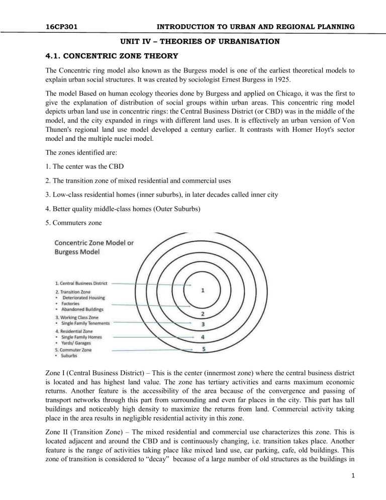
16CP301 INTRODUCTION TO URBAN AND REGIONAL PLANNING UNIT IV – THEORIES OF URBANISATION 4.1. CONCENTRIC ZONE THEORY The Concentric ring model also known as the Burgess model is one of the earliest theoretical models to explain urban social structures. It was created by sociologist Ernest Burgess in 1925. The model Based on human ecology theories done by Burgess and applied on Chicago, it was the first to give the explanation of distribution of social groups within urban areas. This concentric ring model depicts urban land use in concentric rings: the Central Business District (or CBD) was in the middle of the model, and the city expanded in rings with different land uses. It is effectively an urban version of Von Thunen's regional land use model developed a century earlier. It contrasts with Homer Hoyt's sector model and the multiple nuclei model. The zones identified are: 1. The center was the CBD 2. The transition zone of mixed residential and commercial uses 3. Low-class residential homes (inner suburbs), in later decades called inner city 4. Better quality middle-class homes (Outer Suburbs) 5. Commuters zone Zone I (Central Business District) – This is the center (innermost zone) where the central business district is located and has highest land value. The zone has tertiary activities and earns maximum economic returns. Another feature is the accessibility of the area because of the convergence and passing of transport networks through this part from surrounding and even far places in the city. This part has tall buildings and noticeably high density to maximize the returns from land. Commercial activity taking place in the area results in negligible residential activity in this zone. Zone II (Transition Zone) – The mixed residential and commercial use characterizes this zone. This is located adjacent and around the CBD and is continuously changing, i.e. transition takes place. Another feature is the range of activities taking place like mixed land use, car parking, cafe, old buildings. This zone of transition is considered to “decay” because of a large number of old structures as the buildings in 1 16CP301 INTRODUCTION TO URBAN AND REGIONAL PLANNING transition zone were earlier used for factories and tenement housing blocks. This zone had a high population density when industrial activities were at their peak. Those residing in this zone were of the poorest segment and had the lowest housing condition. Zone III (Inner City/ Working Class zone) – This area is occupied for residential purpose and also known as “inner city” or “inner suburbs.” It consisted of houses built to accommodate factory workers but had better condition than the transition zone. This area has a mix of new and old development and generally requires orderly redevelopment. People living in this zone are second generation immigrants as many moves out of the transition zone to this zone whenever affordable. This zone is nearest to the working area with modest living conditions, and this resulted in reduced commuting cost. Another interesting feature includes the large rental housing occupied by single workers. Zone IV (Outer Suburbs/ White Collar Homes) – This zone had bigger houses and new development occupied by the middle class. Many of the homes are detached, and unlike single occupants of inner suburbs, families resided in these homes. Better facilities are available to the residents like parks, open spaces, shops, large gardens but this comes at an increased commuting cost. This zone has a large area of residential land. People living in this outer ring look for better quality of life. Zone V (Commuter Zone) – This is the peripheral area and farthest from the CBD, this resulted in highest commuting cost when compared with other zones. Significant commuting cost gave the name “commuter zone” to this part. People living in this part were high-income groups which could afford large houses, could pay commuting charges, had access to different transportation mode, enjoy modern facilities like shopping malls. Low rise development, large gardens, less population density are some of the characteristics of this zone. This zone offered the highest quality of life and facilities but at a cost of higher commuting cost. Burgess often observed that there was a correlation between the distance from the CBD and the wealth of the inhabited area; wealthier families tended to live much further away from the Central Business District. As the city grew, Burgess also observed that the CBD would cause it to expand outwards; this in turn forced the other rings to expand outwards as well. The model is more detailed than the traditional down-mid-uptown divide by which downtown is the CBD, uptown the affluent residential outer ring, and midtown in between. Burgess's work is based on the bid rent curve. This theory states that the concentric circles are based on the amount that people will pay for the land. This value is based on the profits that are obtainable from maintaining a business on that land. The center of the town will have the highest number of customers so it is profitable for retail activities. Manufacturing will pay slightly less for the land as they are only interested in the accessibility for workers, 'goods in' and 'goods out'. Residential land use will take the surrounding land. 2 16CP301 INTRODUCTION TO URBAN AND REGIONAL PLANNING Criticisms The model has been challenged by many contemporary urban geographers. First, the model does not work well with cities outside the United States, in particular with those developed under different historical contexts. Even in the United States, because of changes such as advancement in transportation and information technology and transformation in global economy, cities are no longer organized with clear "zones" • It describes the peculiar American geography, where the inner city is poor while suburbs are wealthy; the converse is the norm elsewhere • It assumes an isotropic plain - an even, unchanging landscape • Physical features - land may restrict growth of certain sectors; hills and water features may make some locations unusually desirable for residential purposes • Commuter villages defy the theory, being in the commuter zone but located far from the city • Decentralization of shops, manufacturing industry, and entertainment • Urban regeneration and gentrification - more expensive property can be found in 'low class' housing areas • Many new housing estates were built on the edges of cities in Britain • It does not address local urban politics and forces of globalization • The model does not fit polycentric cities, for example Stoke-on-Trent 4.2. Sector Model Hoyt Model is somewhat similar to Burgess Model and is often considered as its improved version. Hoyt argued that cities do not develop in the form of simple rings, instead, they have “sectors.” Homer Hoyt in 1939 suggested that few activities grow in the form of sectors which radiates out along the main travel links. Activities in a sector are considered to be the same throughout the sector because of the purpose/function it serves. Land use within each sector would remain the same because like attracts like. The high-class sector would stay high-class because it would be the most sought after area to live, so only the rich could afford to live there. The industrial sector would remain industrial as the area would have a typical advantage of a railway line or river. These sectors can be housing, industrial activities, etc. These sectors grow along railway lines, highways or rivers. 3 16CP301 INTRODUCTION TO URBAN AND REGIONAL PLANNING Components of Hoyt Model CBD – Central Business District is placed at the center. Sectors and the partial rings of land use/activities take place. This area is often known as downtown and has high rise buildings. Inner city area or downtown area is a complex and dynamic organism. It represents many layers of historic growth of many generations impact of cultural and traditions of men who inhabited the city as tourists. The combinations of these layers and the way they are held together in the city gives imageability, out of its socio-cultural heritage. As the cities expands and modern technology and scientific innovations transformed the style of living and also the structure of the city, open spaces were being eaten up by built forms resulting in congested and unhealthy environment. Industry – Industries are represented in the form of a sector radiating out from the center. These forms sector because of the presence of a transport linkage along which the activities grew. Presence of railway line, river or road would attract similar activity, and thus a continuous corridor or “sector” will develop. Apart from the industries this area also serves as a residential area for lower class workers. Living conditions are bad because of proximity to industries. Low-Class Residential Low-income groups reside in this area. Narrow roads, high population density, small houses with poor ventilation exist in this area. Roads are narrow and often connects to the industries where most of the people in this sector work. Closeness to industries reduces the travel cost and thus attracts industrial workers. Environmental and living conditions are often inadequate because of the proximity to factories. Middle-Class Residential This area has middle income groups who can afford more substantial travel cost and want better living conditions. The activities of people residing in this area consist of different activities and not just the industrial work. It has more linkages with CBD along with some linkages to industries. This area has the most significant residential area. High Class residential This is the outermost and farthest area from the downtown. Wealthy and affluent people live in this area. This area is clean, has less traffic, quiet and has large houses. Corridor or spine extending from CBD to the edge has the best housing. The significance of Hoyt Model • Ecological factors + economic rent concept to explain the land use pattern • Stress on the role of transport routes in affecting the spatial arrangement of the city • Both the distance and direction of growth from the city center are considered • Brings location of industrial and environmental amenity values as determinants in a residential place • Example: Sectors of high-class residential areas tend to grow towards higher grounds, sites with a better view, more open space, the homes of influential leaders within the community and existing outlying, smaller settlements. Limitations of Sector Model 4 16CP301 INTRODUCTION TO URBAN AND REGIONAL PLANNING • Only Railway lines are considered for the growth of sectors and do not make allowances for private cars. • It is a monocentric representation of cities; multiple business centers are not accounted for in this model. • Physical features – physical features may restrict or direct growth along specific wedges • No reference to out of town development Features of sector model • Presence of low-income groups near industries supports Hoyt Model • The Hoyt model realized that transportation (in particular) and access to resources caused a disruption of the Burgess model. • Transport linkages profoundly influence activities and their locations. Low transportation cost and proximity to roads/railway reduce the cost of production. • This model applies well to Chicago • Account for major transportation routes and its effect on activities 4.3. Multiple Nuclie Model Multiple nuclei model of 1945 by C.D. Harris and Edward L. Ullman is based on the argument that the cities have multiple growth points or “nuclei” around which growth take place. This model was given in an article by them “The Nature of Cities.” This is one of the widely adopted models which was applicable to modern cities unlike older models studied under settlement geography. This model is based on the structure of Chicago just like the Burgess model or Concentric zone model of 1925. It can be considered as an attempt to explain the structure of the city taking into account the complexity and growth over time. Harris and Ullman argued that a city might start with a single central business district (CBD), but over the time the activities scatter and gets modified. The scattered activities attract people from surrounding areas and act as smaller nuclei in itself. These small nuclei gain importance and grow in size and start influencing the growth of activities around them. The need for this model was to provide a more realistic explanation of the cities. The influence of cars on personal travel and greater movement of goods offered opportunity in different places instead of concentrating all economic activities in one place. People started optimizing their business for maximum profit by locating at a different place and bringing down their rent with a slight increase in transportation cost. Whereas some activities like industrial areas create pollution and are thus preferred to be located away from residential areas. This model is considered to be more suitable for cities which are large and expanding. Activities listed under the model The activities listed in the model can be considered as independent zones which influences activities around them. These are also formed because of their dependence on one another when such activities are located in proximity a “nuclei” is said to be developed. 5 16CP301 INTRODUCTION TO URBAN AND REGIONAL PLANNING Assumptions for Multiple Nuclei Model • The land is not flat – This provides a more practical application of the multiple nuclei model and is an improvement over the Burgess model. It is difficult to find flat land for big cities, and the terrain features affects the activities, development, and direction of growth of an urban area. • Even distribution of resources – Resources are evenly distributed within the city, no one enjoys privileges or have exclusive access to resources. • Even distribution of people in Residential areas – People are distributed homogeneously and not concentrated in a particular area or pocket. This is essential as an unevenly distributed population has a direct impact on markets. • Even transportation cost – Transportation cost is even in the city and not influenced by location. • Profit maximization – A particular activity will locate itself where maximum profit can be earned. For this, a different combination of rent, transportation costs, labor cost, proximity to market may be tried, and the combination which yields the best result gives the final location for the activity. This location also takes into account the restrictions over the activity and the need to be separated from other non compatible activities such as locating residential areas away from industrial, locating large industries with more accessibility to reduce transportation cost and to ease the movement of goods. Limitations and criticism of the Harris & Ullman’s Multiple Nuclei Model Multiple nuclei model was considered much better than the previous simple models which attempted to explain the structure of urban areas. However, this model also had its limitations and could not be applied to many cities and did not entirely explain the structure of urban areas. Formation of well-defined zones or “nuclei” required the considerable size of the city as the small or new towns do not have a very well defined location because of which they are usually scattered. Another drawback is the limited activities which are considered in the model along with the very rigid and specific boundaries of the activities. Some other disadvantages include: 6 16CP301 INTRODUCTION TO URBAN AND REGIONAL PLANNING • • • • • • Negligence of the height of buildings. Non-existence of abrupt divisions between zones. Each zone displays a significant degree of internal heterogeneity and not homogeneity. Unawareness of inertia forces. No consideration of the influence of physical relief and government policy. The concepts may not apply to Asian cities with different cultural, economic and political backgrounds. 4.4. Galactic City Model The word galactic is derived from the word Galaxy in astronomy. Galaxy is a gravitationally bound system of stars, planets and other celestial bodies in the universe. Galaxy is a word derived from “Galaktikos” which means milky circle. These celestial bodies in the galaxy usually revolve around a center gravitational pull of a galaxy. So this is a circular system with an established center. Galactic city model is based on the concept of galaxies in space. It is also called as peripheral city model and is used for urban planning in many cities. It is a well known model in urban geography. An overview of Galactic City Model Galactic city model is a circular city model that has become popular with post-industrial cities. Galactic model has a commercial and economic central area which is often called the central business district or CBD is at the center of the city. The basic concept of this type of city model is high rise buildings in the city center. Low rise homes, residential areas and industrial, recreational and shopping districts surrounds the center of the city. This is a much planned urban model of cities. The city then expands in a circular fashion around the CBD. The following are some of the elements of the galactic city model: Elements of Galactic City Model CBD or City Center: The central business district or city center of the city is often the geographical heart of the city. This acts as the cultural, business, economic and political center of a city. In the CBD area, there are often skyscrapers and commercial buildings and town halls, government buildings and also buildings that represent the historic past of the city. The galactic city model has a high-density nucleus or city center and then the city expands in a circular fashion around the city center. The central urban area of the city is very high density in terms of population as compared to the urban sprawl surrounding it. Suburban Residential Area: The city sprawls around the city center or CBD in a galactic city model. A portion of the city is the suburban residential area. This area is characterized as a residential district of the city with small and high homes, good schools and a suburban-style look to the district. This area lies inside the outer periphery of the galactic city model. It has hotels, parks, medical centers and all essential infrastructures for a residential area. Circumferential Highway: The galactic city model is a circular city model with a center and a radius around the center which makes the city. The circumference of the city is often characterized by a circumferential circular highway that surrounds the entire city. This highway helps people avoid the traffic within the city and reach from one side of the city to another through the outer periphery of the city. Radial Highways: Besides the circumferential highways, there are radial highways. These highways connect the periphery of the city from various points to the center CBD area of the city. These are often the main highways of the city which are also linked to the arterial roads within the city. 7 16CP301 INTRODUCTION TO URBAN AND REGIONAL PLANNING Shopping Center: Usually, in a galactic model, a shopping center or shopping district of a city is next to the residential area of the city and not in the city center. This makes it easier for residents living in the suburban residential zones of the city, to do their shopping in the nearby shopping district of the city. This is not a very strict rule as there are shopping centers all over the city. Industrial District: Every major city in the world has industrial development. This means that there are industrial plants and factories in major cities all over the world. The industrial district in a galactic model of cities is located in one arc of this circular type of cities. Often these industrial districts are located on the other side of the residential areas. This is to keep the residential areas and industrial districts separate. Edge Cities: Galactic model of cities often has many edge cities on the outskirts beyond the periphery of the main city. Edge city is a concept of a concentration of commercial and recreational infrastructure outside the city. These edge cities are often parts of the main city and are far away from the city center. They are often joined to the city center by highways or main roads. Edge cities have business centers, shopping centers and entertainment destinations for the residents of the main city. Office Parks, Service Centers, Employment & Shopping Centers: Edge cities as described above are often beyond the peripheral edge of a city. Office parks are a concentration of offices outside the city limits. A good example of this is a software park. To encourage the software industry, a software park is a type of edge city where there is a concentration of software technology offices outside the city. Service centers, employment centers, and shopping centers are other types of high-density urban zones nearby outside the periphery of the galactic city model. Airports: Generally, airports are outside city limits and far away from the city center in most cities in the world. An airport in the galactic city model is also outside the city. It is connected to the city with either the peripheral highways or the radial highways that are part of this type of city model. 4.5. Central Place Theory Central place theory was given by Walter Christaller in 1933, CPT in urban geography is one of the most appreciated theories which tries to explain the spatial arrangements and distribution of human settlements and their number based on population and distance from another human settlement. This theory was first given by German geographer Walter Christaller in 1933, on the basis of his study of settlement patterns in southern Germany. This study included the analyzing the relationships between settlements of different sizes and related their economic activities (market) with the population. Walter Christaller explained why the highest order settlement has very peculiar activities which can only be supported by them and the reason behind those activities taking place only in those particular highest order settlements, he also explained the nature of activities in different order of settlements. Central place theory is of great importance even after decades and forms the basis of various present-day theories used in urban planning. • The theory is essentially static, explaining the existence of a regional spatial structure but failing to explain how that structure has evolved and it might change in the future. • It serves a useful role identifying important concepts such as the interdependence of a city and region, a hierarchy of functions and centers, and market range and threshold populations. • Range also depends on the type of demand of the central good. If the demand is inelastic (urgent, non-substitutable; e.g. Hospital), then the range is large and if the demand is elastic then range is smaller (e.g. Cinema) 8 16CP301 INTRODUCTION TO URBAN AND REGIONAL PLANNING • Larger the central place, the greater will be the range as compared to smaller central places. (lower production cost leads to larger amount of sales). • Higher the population density implies greater range, as again higher density make production cheaper. Assumptions of Christaller’s Central place theory Christaller made some assumptions to make his theory easy to understand and form the basis for other theories. These assumptions were necessary and hold good to explain the structure of settlements. These also take into account the growth and development of towns, human behavior and fundamentals of economics. Walter Christaller made following assumptions: • An even (flat) terrain – A hilly and uneven terrain poses difficulty in development thus a flat area which promotes the growth of the town • Evenly distributed population – residents are not concentrated at one particular place and no preference exists for a particular town • Evenly distributed resources – no place has an advantage of resources, all placed will compete under perfect market conditions • Similar purchasing power – along with the population and resources, wealth is also fairly distributed. Because of this people have similar purchasing power • Preference for the nearest market – people will buy products from the nearest market and avoid the long commute. This keeps price constant as per other assumptions • Equal transportation cost (proportional to distance) – the cost incurred in transporting of goods is equal for all and is proportional to the distance • Perfect competition – price is decided on basis of demand and supply. People will buy at the lowest price which market has to offer, no seller has an advantage over another seller. Two main concepts of Central Place Theory • Threshold – The minimum population needed to make a service viable at a particular place. If this size is not reached then a particular activity will not start or it will be closed down. • Range – This is the maximum distance a consumer is willing to travel to purchase good or avail a service, beyond this distance consumer will not travel as the distance traveled for good/service will outweigh the benefit. Range has two limits, Upper Limit denotes an area beyond which there will be no buyer willing to travel. And, Lower Limit denotes an area need for a firm to make profits and have sufficient demand. 9 16CP301 INTRODUCTION TO URBAN AND REGIONAL PLANNING Sizes of settlements/communities as per central place theory Walter Christaller gave a system with 5 sizes of settlements based on population. The smallest unit is Hamlet which is considered a rural community and the largest unit is Regional Capital. The rank order of central places in ascending order include: • Hamlet • Village • Town • City • Regional Capital/ Metropolis Markets and Services tend to be nested hierarchies with smaller towns serving smaller markets. However, transportation and border effects can shift the distribution of towns away from theoretical uniformity. The arrangement of the Central places/ settlements: As transport is equally easy in all direction, each central place will have a circular market area as shown in C in the following diagram: However, the circular shape of the market areas results in either un-served areas or over-served areas. To solve this problem, Christaller suggested the hexagonal shape of the markets as shown in D in the above diagram. Within a given area there will be fewer high order cities and towns in relation to the lower order villages and hamlets. For any given order, theoretically, the settlements will be equidistant from each other. The higher order settlements will be further apart than the lower order ones. Principles in the arrangement of the central places: Christaller’s theory gives 3 principles which are the marketing principle, transport principle and administrative principle for orderly arrangements and the formation of hierarchy. Settlements are regularly spaced – equidistant spacing between same order centers, with larger centers farther apart as compared to smaller centers. The market area is hexagonal shaped as it is free from overlapping, most 10 16CP301 INTRODUCTION TO URBAN AND REGIONAL PLANNING efficient in both number and function. Three Principles of Christaller for determining distribution of central places in a region. Marketing principle: If the distribution is entirely based on the range of the good, then it would result in evenly spaced central places with hexagonal markets area. Traffic principle: If any central place (city) is smaller in size than expected than it be because of lower accessibility (not falling on major transport route) and vice-versa Separation principle: Spacing and sizing of Central places can sometimes be distorted due to sociopolitical consideration. The different layouts predicted by Christaller have K- values which show how much the Sphere of Influence of the central places takes in — the central place itself counts as 1 and each portion of a satellite counts as its portion: • Marketing Principle (K=3) • Transport Principle/ Traffic Principle (K=4) • Administrative Principle (K=7) The three principles of central place theory are as follows Marketing Principle (K=3): As per this the market area of a higher order occupies one-third (1/3 part) of the market area of each of the consecutive lower size place(node) which lies on its neighbor. The lower size nodes (6 in numbers and 2nd larger circles) are located at the corner of the largest hexagon around the high-order settlement. Each high-order settlement gets 1/3rd of each satellite settlement (which are 6 in total), thus K = 1 + 6×1/3 = 3. With K=3 the transport network is not efficient even when the distance traveled is reduced. This is because of the absence of transport links (network) between the larger places (nodes). Transport Principle (K=4): This provides for most efficient transport network. High order place half of the market area of 6 neighboring lower order places located on the edge of the hexagon formed by high order settlement. There are maximum central places possible. These are located on the main transport routes connecting the higher order center. The transportation principle involves the minimization of the 11 16CP301 INTRODUCTION TO URBAN AND REGIONAL PLANNING length of roads connecting central places at all hierarchy levels. In this system of nesting, the lower order centers are all located along the roads linking the higher order centers. This alignment of places along a road leads to minimization of road length. However, for each higher order center, there are now four centers of immediate lower order, as opposed to three centers under the marketing principle. Administrative Principle (K=7): According to K = 7 administrative principle (or political-social principle), settlements are nested according to sevens. The market areas of the smaller settlements are completely enclosed within the market area of the larger settlement. Since tributary areas cannot be split administratively, they must be allocated exclusively to a single higher-order place. Efficient administration is the control principle in this hierarchy. Hierarchy of Central Places Christaller suggested that the central places, providing goods and services to the surrounding areas would form a hierarchy. A large number of widely distributed small places would provide lower order goods and services to service regular widespread demand. There would be a smaller number of larger centers providing both lower-order and higher-order goods and services. Successive steps of the hierarchy would consist of larger central places providing even higher-order goods and services. 12 16CP301 INTRODUCTION TO URBAN AND REGIONAL PLANNING Criticism & limitations of Christaller’s central place theory Central Place Theory is widely appreciated and used but has its own limitations. These include the assumptions which are unrealistic. The basic assumptions are flawed. It is nearly impossible to have very large flat terrain, perfect market, and absence of preference for shopping places. Today’s economy is a capitalist economy, but government plays an equally important role which has a strong influence on the market and the location of activities. Moreover, the resources are never equally distributed, and some enjoy disproportionate benefits. Same is true for purchasing power. Thus to make it functional as per actual scenario various modifications are required in the basic theory. Theory relates only to the service sector 4.6. Land Use and Land Value Theory Model made based off observations in 1826 by J.H Von Thunen where agriculture is grown and where people live. This model explains the development of agricultural towns and cities. Assumptions of Von Thunen • The city is located centrally within an "Isolated State" which is self sufficient and has no external influences. • The Isolated State is surrounded by an unoccupied wilderness. • The land of the State is completely flat and has no rivers or mountains to interrupt the terrain. • The soil quality and climate are consistent throughout the State. • Farmers in the Isolated State transport their own goods to market via oxcart, across land, directly to the central city. Therefore, there are no roads. • Farmers act to maximize profits. 13 16CP301 INTRODUCTION TO URBAN AND REGIONAL PLANNING Layer 1: Urban Center/Market - At the heart of the model is the city, where the people live and work. Primarily where agricultural products are brought to be sold. Layer 2: Horticulture and Dairy Farming - Horticulture is primarily the growing of fruits, vegetables, and flowers. Dairy farming is done close enough to transport milk to market without spoiling. Layer 3: Forestry - Ring of trees to provide building materials and firewood – Model produced before widespread use of coal. Located close for easy transportation. Layer 4: Grains/Field Crops - Large scale farms that allow for Grain production and large herds of animals – Grains much lighter and easier to transport Layer 5: Extensive Ranching and Grazing - Large open areas where animals can freely roam. Transportation a nonfactor since animals are self-transporting and can walk to market or easily be moved. Uses of Von Thunen’s Model • Von Thunen model useful generalizing agriculture patterns – Opens up discussion to merits and changes in agriculture – Displays connection of city and agricultural patterns • Displays balance between land costs and transportation costs 14
