Lower Siuslaw River Watershed Lane and Douglas Counties, Oregon Introduction
advertisement

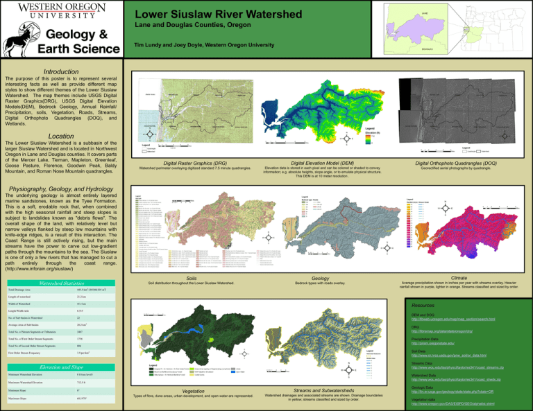
Lower Siuslaw River Watershed Lane and Douglas Counties, Oregon Tim Lundy and Joey Doyle, Western Oregon University Introduction The purpose of this poster is to represent several interesting facts as well as provide different map styles to show different themes of the Lower Siuslaw Watershed. The map themes include USGS Digital Raster Graphics(DRG), USGS Digital Elevation Models(DEM), Bedrock Geology, Annual Rainfall/ Precipitation, soils, Vegetation, Roads, Streams, Digital Orthophoto Quadrangles (DOQ), and Wetlands. Location The Lower Siuslaw Watershed is a subbasin of the larger Siuslaw Watershed and is located in Northwest Oregon in Lane and Douglas counties. It covers parts of the Mercer Lake, Tiernan, Mapleton, Greenleaf, Goose Pasture, Florence, Goodwin Peak, Baldy Mountain, and Roman Nose Mountain quadrangles. Digital Raster Graphics (DRG) Digital Elevation Model (DEM) Digital Orthophoto Quadrangles (DOQ) Watershed perimeter overlaying digitized standard 7.5 minute quadrangles. Elevation data is stored in each pixel and can be colored or shaded to convey information; e.g. absolute heights, slope angle, or to emulate physical structure. This DEM is at 10 meter resolution . Georectified aerial photographs by quadrangle. Physiography, Geology, and Hydrology The underlying geology is almost entirely layered marine sandstones, known as the Tyee Formation. This is a soft, erodable rock that, when combined with the high seasonal rainfall and steep slopes is subject to landslides known as "debris flows". The overall shape of the land, with relatively level but narrow valleys flanked by steep low mountains with knife-edge ridges, is a result of this interaction. The Coast Range is still actively rising, but the main streams have the power to carve out low-gradient paths through the mountains to the sea. The Siuslaw is one of only a few rivers that has managed to cut a path entirely through the coast range. (http://www.inforain.org/siuslaw/) Watershed Statistics Total Drainage Area 445.5 km2 (445466105 m2) Length of watershed 21.2 km Width of Watershed 41.1 km Length/Width ratio 0.515 No. of Sub-basins in Watershed 22 Average Area of Sub-basins 20.2 km2 Total No. of Stream Segments or Tributaries 3407 Total No. of First Order Stream Segments 1758 Total No of Second Order Stream Segments 806 First Order Stream Frequency 3.9 per km2 Soils Geology Climate Soil distribution throughout the Lower Siuslaw Watershed. Bedrock types with roads overlay. Average precipitation shown in inches per year with streams overlay. Heavier rainfall shown in purple, lighter in orange. Streams classified and sized by order. Resources DEM and DOQ http://libweb.uoregon.edu/map/map_section/search.html DRG http://libremap.org/data/state/oregon/drg/ Precipitation Data http://prism.oregonstate.edu/ Soil Data http://www.or.nrcs.usda.gov/pnw_soil/or_data.html Streams Data http://www.wou.edu/las/physci/taylor/es341/coast_streams.zip Elevation and Slope Minimum Watershed Elevation 0 ft (sea level) Maximum Watershed Elevation 712.5 ft Minimum Slope Maximum Slope 0° 68.1978° Watershed Data http://www.wou.edu/las/physci/taylor/es341/coast_sheds.zip Vegetation Streams and Subwatersheds Types of flora, dune areas, urban development, and open water are represented. Watershed drainages and associated streams are shown. Drainage boundaries in yellow; streams classified and sized by order. Geologic Data http://tin.er.usgs.gov/geology/state/state.php?state=OR Vegetation data http://www.oregon.gov/DAS/EISPD/GEO/alphalist.shtml


