2D Mapping of Cluttered Indoor Environments by Means of 3D Perception
advertisement
Proceedings of the 2004 IEEE
International Conference on Robotics & Automation
New Orleans, LA • April 2004
2D Mapping of Cluttered Indoor Environments
by Means of 3D Perception
Oliver Wulf 1, Kai O. Arras 2, Henrik I. Christensen 2 and Bernardo Wagner 1
1
2
Institute for Systems Engineering (ISE/RTS)
University of Hannover
Hannover, Germany
{wulf,wagner}@rts.uni-hannover.de
Abstract— This paper presents a combination of a 3D laser
sensor and a line-base SLAM algorithm which together produce
2D line maps of highly cluttered indoor environments. The key of
the described method is the replacement of commonly used 2D
laser range sensors by 3D perception. A straightforward
algorithm extracts a virtual 2D scan that also contains partially
occluded walls. These virtual scans are used as input for SLAM
using line segments as features. The paper presents the used
algorithms and experimental results that were made in a former
industrial bakery. The focus lies on scenes that are known to be
problematic for pure 2D systems. The results demonstrate that
mapping indoor environments can be made robust with respect
to both, poor odometry and clutter.
I.
Centre for Autonomous Systems (CAS)
Royal Institute of Technology
Stockholm, Sweden
{kai-a,hic}@nada.kth.se
sensors are especially distinct in these environments. One
procedure in this application is to build up full 3D navigation
systems including a 3D sensor and a 3D or 2½D map
representations [4][5]. These systems can be used in
completely unstructured environments but they have the
disadvantage of being computationally very expensive. An
alternative method for 3D outdoor navigation is described in
[6]. The system combines a 3D sensor with a 2D SLAM
algorithm and map representation for semi structured outdoor
environments. By this means it takes advantage of 3D
perception in combination with less complex 2D navigation
algorithms.
INTRODUCTION
In many typical robot settings for indoor navigation, a
range sensor takes measurements in a plane parallel to the
floor. The supposition that this cross-section contains enough
information for the robot to navigate is commonly called the
“2D assumption”. However, even structured indoor
environments can be hard to model if dynamic objects and
clutter dominate over the static structures which are good for
navigation. More sophisticated feature extraction algorithms or
the explicit modeling of dynamic objects during the mapping
process [4] are examples of worthwhile approaches to be
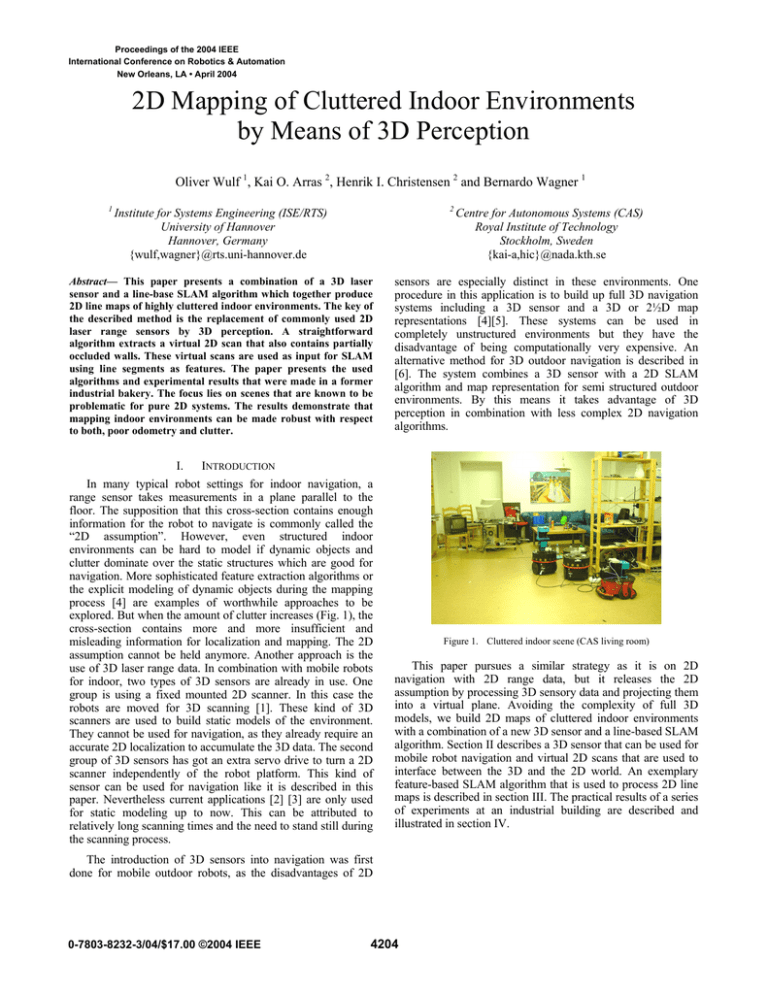
explored. But when the amount of clutter increases (Fig. 1), the
cross-section contains more and more insufficient and
misleading information for localization and mapping. The 2D
assumption cannot be held anymore. Another approach is the
use of 3D laser range data. In combination with mobile robots
for indoor, two types of 3D sensors are already in use. One
group is using a fixed mounted 2D scanner. In this case the
robots are moved for 3D scanning [1]. These kind of 3D
scanners are used to build static models of the environment.
They cannot be used for navigation, as they already require an
accurate 2D localization to accumulate the 3D data. The second
group of 3D sensors has got an extra servo drive to turn a 2D
scanner independently of the robot platform. This kind of
sensor can be used for navigation like it is described in this
paper. Nevertheless current applications [2] [3] are only used
for static modeling up to now. This can be attributed to
relatively long scanning times and the need to stand still during
the scanning process.
Figure 1. Cluttered indoor scene (CAS living room)
This paper pursues a similar strategy as it is on 2D
navigation with 2D range data, but it releases the 2D
assumption by processing 3D sensory data and projecting them
into a virtual plane. Avoiding the complexity of full 3D
models, we build 2D maps of cluttered indoor environments
with a combination of a new 3D sensor and a line-based SLAM
algorithm. Section II describes a 3D sensor that can be used for
mobile robot navigation and virtual 2D scans that are used to
interface between the 3D and the 2D world. An exemplary
feature-based SLAM algorithm that is used to process 2D line
maps is described in section III. The practical results of a series
of experiments at an industrial building are described and
illustrated in section IV.
The introduction of 3D sensors into navigation was first
done for mobile outdoor robots, as the disadvantages of 2D
0-7803-8232-3/04/$17.00 ©2004 IEEE
4204
II.
3D PERCEPTION
The 3D perception system that is described in this paper
consists of two parts. The first is a fast 3D laser range sensor
that is especially adapted for use on mobile robots. This
scanner is described in section IIa. The second part is a
construction called virtual 2D scans. Section IIb will introduce
these virtual scans and will also present an algorithm that is
able to extract them out of 3D point-clouds.
A. Fast 3D Laser Range Scans
As there is no commercial 3D laser range scanner available
which could be used for mobile robots, it is common practice
to assemble 3D sensors out of a standard 2D scanner and an
additional servo drive [7]. A scanner that is used in our system
is the SICK LMS 291 in combination with a self-build servo
drive (scan drive). Different orientations of the 2D scanner in
combination with different turning axis result in a number of
possible scanning patterns. Two scanning patterns that are
practicable for our application are the yawing scan, vertical 2D
raw scan and rotation around the upright axis (see Fig. 2a), and
the yawing scan top, 2D raw scan facing up and rotation
around the upright axis (see Fig. 2b). The yawing scan pattern
results in the maximal possible field of view of 360° horizontal
and 180° vertical. The yawing scan top has got also a
horizontal opening angle of 360° but it covers only the upper
hemisphere. For this reason a sensor with such a scanning
pattern is not able to detect obstacles that lie on the ground. On
the other hand the data is sufficient for localization and
mapping and the scan time, which is half of the yawing scan
time, is attractive for faster motion.
(a)
(b)
Figure 2. Continuously turning 3D scanner:
(a) yawing scan, (b) yawing scan top
Short scanning times and the ability to scan while moving
are the main criteria that decide on the usability of 3D scanners
for navigation tasks. For this reason the sensor that is used in
this paper contains a number of improvements. One
mechanical improvement is the ability of the scan drive to turn
continuously, which is implemented by using slip rings for
power and data connection to the 2D scanner. This leads to a
homogeneous distribution of scan points and saves the energy
and time that is needed for acceleration and deceleration of
panning scanners. Another improvement that becomes
important with short scanning times of a few seconds is the
compensation of systematic measurement errors. This
compensation is done by means of sensor analysis and hard
real-time synchronization and time stamping. The result of
these optimizations that are described in detail in [7] lead to
scan times as short as 4.8s for a yawing scan with 1° horizontal
and 1° vertical resolution (see Fig. 3), 2.4s for a 2°, 1° yawing
scan or a 1°, 1° yawing scan top or only 1.2s for a yawing scan
top with 2°, 1° resolution. Another feature is the ability to scan
while driving, which is achieved with a move compensation
algorithm [6]. This algorithm is using a 3D dead-reckoning
mechanism that combines wheel odometry and a gyroscope.
The estimated robot position is used to transform the 3D pointcloud into a world fixed and therefore undistorted coordinate
frame.
Figure 3. 3D point-cloud yawing scan 1°, 1°
B. Virtual 2D Scans
The 3D point-clouds that are acquired by the 3D scanner
contain detailed information about the surrounding
environment. Because 3D point-clouds are raw data
representations, they include redundant information and many
measurement points which are not needed for localization and
mapping. Approaches which use this raw data for scan
matching and full 3D modeling are computational very
expensive. If the goal is to localize or navigate a mobile robot,
these full 3D algorithms are not efficient. The use of virtual 2D
scans is more efficient here as it aims to reduce the amount of
data without loosing information that is essential for mobile
robot localization. The reduced data sets can afterwards be
used for computationally less expensive matching and SLAM
algorithms. The data representation that is chosen of virtual 2D
scans is similar to the data that can be measured directly with a
2D laser range sensor. It is defined as a number of object
surface points that are given in a 2D robot coordinate system.
For this reason existing 2D scanners can be replaced by more
intelligent 3D perception systems and can be used by keeping
existing 2D SLAM algorithms.
These intelligent sensors are based on algorithms that are
able to extract the information that is essential for SLAM out
of 3D point-clouds. This paper describes a first,
straightforward, heuristic that extracts virtual scans from
cluttered indoor scenes. Objects that are preferably used for
indoor localization are walls because they are immobile and
efficiently modeled as lines. The first step to create this virtual
2D scan is to project all 3D points onto the plane by setting the
4205
z-coordinate to zero. A virtual 2D scan that contains primarily
walls can thereafter be assembled by taking one point out of
each vertical raw scan (resp. two points for a yawing scan top).
This point is chosen to be the one with the largest distant to the
center of the robot. As walls build the boundary of a closed
indoor scene the chosen point is most probably a wall point. By
this means points lying on the floor, ceiling or on obstacles are
filtered out. The thus generated 2D scan is only disturbed by
open doors, windows and objects that cover the wall
completely. Fig. 4 shows a virtual 2D scan of the CAS living
room in comparison to a regular 2D range scan taken at 50cm
height. A photograph and one view of the 3D point-cloud from
the same room can be seen in Fig. 1 and Fig. 3.
B. Robot Displacement
A differential drive configuration is used as the kinematic
model for the robot. This simplification allows us to apply an
uncertainty model that models non-systematic odometry errors
(correctly) in the wheel space and not in the Cartesian space
[11]. From the odometry data delivered by the wheel encoders
for the robot x- and y-position and the IMU device for the
vehicle orientation, the encoder values for the left and right
wheel are determined and taken as inputs for the kinematic
model. Given a higher frequency odometry update with
respect to the rate of the observations, a recursive formulation
yields the sought process model Jacobian. This Jacobian is
needed to update the first row and column of the map
covariance matrix during the state prediction step.
C. Observation
The line extraction algorithm from [12] has been used. It uses
a sliding window technique and fit expressions that minimizes
weighted squared errors perpendicular from the points onto
the line. Its complexity is O(n*nw) where n is the number of
scan points, nw the size of the window and nw<<n holds.
Collinear segments are fused in a final steps using an NNSFlike clustering algorithm based on a Mahalanobis distance
matrix.
Figure 4. Virtual 2D scan (black), Regular 2D scan (50cm height, red)
III.
LINE-BASED SLAM
This section describes the line-based SLAM algorithm which
has been employed for the experiments. Assuming that the
reader is familiar with the standard SLAM framework as
initially proposed by [8], [9] we will focus on the particularity
of our method.
A. Feature Representation
When lines are used as landmarks for SLAM the
representation problem of uncertain features becomes visible.
Several line models have shortcomings when used for SLAM
such as the Hessian (alpha, r)-representation whose error
propagation across frame transforms leads to physically
meaningless covariance matrices. Here we use the SPmodel
[10] to represent line segments. In the SPmodel, a reference
frame is attached by default to each feature regardless its type.
Errors are represented locally in that frame and in case of a
non-full pose feature (e.g. lines or (x,y)-points) the so called
binding matrix selects those rows in the feature state vector
that “make sense” for the given feature type.
To represent finite line segments, the segment endpoints are
expressed relative to the frame of the supporting line as single
rank (i.e. one dimensional) locations with a constant
uncorrelated typical uncertainty.
D. Data association
Line segments are an example of features with a physical
extension. This plus of information can be used to support data
association. After measurement prediction, based on the
infinite line parameters, candidates are found which are
compatible on a significance level alpha by means of the usual
validation gate approach. Then, the candidate that has an
overlap length greater than zero maximizing the overlap
between the predicted map feature and the observation is
chosen. For the calculation of the overlap length, endpoints are
transformed into the frame of the map line and projected
prependicularly.
Finally, integration uses an iterative EKF under a strongest
observation policy. We first integrate those observations in the
local map that are most certain thus fostering good filter
convergence. This strategy helps to disambiguate remaining
data association uncertainties during the integration process.
IV.
EXPERIMENTS
This section shows the experimental results of two test runs
made in a 100x100m industrial like indoor environment. The
description includes the used robot system (section IVa), the
test environment (section IVb) and the experimental results
(section IVc).
A. Experimental Setup
The experimental robot consists of an iRobot ATRV based
mobile platform for urban exploration and a 3D laser range
scanner with external processing unit (see Fig. 5). The platform
allows remote controlled driving via WLan. Further more the
onboard unit calculates an odometric position estimation
combining wheel encoders and a fiber optic gyro. The 3D
scanner is built out of a Sick LMS 291 and a scanDrive which
4206
is a servo drive that is especially constructed for fast and
continuous scanning. A scalable processing box (SPB [13])
that is based on an embedded-PC with Linux/RTAI real-time
operating system is doing the 3D scanning and data acquisition.
The ATRV onboard unit and the SPB are interconnected via
CAN-Bus.
scan. This removes a vast of obstacles. Only obstacles that
fully occlude the wall, e.g. people walking closely to the robot
cannot be removed. As the virtual 2D scan contains mostly
wall points it turns out to be ideal input data for the following
2D algorithms. The output is comparable with a 2D scan taken
in an empty room or corridor.
The mapping experiments were carried out with a remote
controlled robot driving at about 0.1m/s. The 3D scanner is set
up to measure full 180°x360° range scans with a resolution of
1°x1°. That results in a scan time of 4.8s. With the robot
driving at the given speed the 3D scanner is able to measure
one 3D scan, respectively one virtual 2D scan, about every
0.5m.
Fig. 6 shows a clipping of a typical scene in a corridor. In
this case two persons, a ladder, open cupboard doors and
several other obstacles occlude the corridor. As it can be seen
in the lower part of Fig. 6, a normal 2D scan (red points)
contains many measurement points on these obstacles in
contrast to the virtual 2D scan (black points) that represents
large parts of the walls.
Within these first experiments, all 3D data processing and
SLAM is done offline in a MATLAB environment.
Figure 5. Experiments in a former industrial bakery
B. Test Environment
A large indoor environment that was used as an industrial
bakery before has been available for the experiments described
in this paper is. Currently it is used as a training site by
Swedish military, police and fire brigades.
The experiments covered two test areas of 20x30m and
30x30m with a number is interconnected rooms. The rooms
have got a flat floor, but there are several steps between rooms.
Though they are traversable with the ATRV, they lead to large
odometry errors. A lot of pipes and electrical installations are
mounted on the walls and on the ceiling (see Fig. 5). Various
obstacles and 6 people were in the test area during the
experiment. Especially because of the occluded walls the test
area is known to be problematic for pure 2D mapping.
C. Results
The algorithm that is used to process virtual 2D scans was
applied to all 208 3D point-clouds out of both test runs. The
experiments show very good and stabile results for wall
extraction in closed indoor scenes. This can be traced back to
the fact that only one correct wall point per vertical 2D scan is
needed to produce a correct representation in the virtual 2D
Figure 6. Experimental data of cluttered corridor
The algorithm was applied to build two maps. The first run,
revisiting the start point twice, consists of 156 steps and
results in a map with 103 landmarks (Fig. 7a & 7b). The
second run, starting in a big hall, has 72 steps and yields a map
with 126 features (Fig. 8a & 8b).
In addition to the clutter in the test environment, two
circumstances made localization and mapping more difficult.
On reason is the large odometry drift of the skid steering
4207
(b)
(a)
Figure 7. Mapping experiment 1: (a) virtual 2D scan and odometry,
(b) line-based map calculated by SLAM algorithm
platform. The second difficulty is the lower data rate of virtual
2D scans in comparison to standard 2D sensors. In our
experiments the observations are made about every 0.5m.
In spite of that the SLAM algorithm was able to calculate
consistent maps for both test runs. This robustness can be
attributed to the use of virtual 2D scans. The 360° opening
angle of the scanner allows the complete observation of the
surrounding. This is especially useful while passing doors, as
features in the old room and in the new room can be seen in
the same scan. Another essential fact benefit is the ability to
observe also partially occluded walls. This contributes to the
localization and mapping process as it provides landmarks that
cannot be seen with a 2D sensor. The fact that obstacles and
clutter are mostly removed from virtual 2D scans allows
having more confidence in the sensed observation. For this
reason the SLAM algorithm needs less observations to add a
new feature into the map correctly.
We further observe an over-segmententation of the map. Walls
are modeled by several, sometimes overlapping segments
where one long segment could be expected. This type of
inconsistency in the description of the environment is typical
for single-segment features and has been observed in [10] and
[12]. As this problem is already known from pure 2D system it
cannot be led back to the new 3D perception.
V.
CONCLUSION
This paper presented a novel method for robust localization
and mapping of cluttered indoor environments. The new ability
to model cluttered environments with line-feature maps is
gained by the use of 3D perception. We introduced an
algorithm to extract virtual 2D scans from full 3D laser range
data. These virtual 2D scans that contain mainly static wall
points are used as input data for a 2D line-based SLAM
algorithm. By this means we presented an effective
combination of rich 3D perception and efficient 2D localization
and mapping. The applicability of this new method was
demonstrated by experiments within industrial indoor
environments.
ACKNOWLEDGMENT
The work described is part of a collaboration within the
project MoRob (Modular Educational Robotic Toolbox), which
is funded by the Swedish Wallenberg Foundation, the German
Federal Ministry of Education and Research and the Research
Ministry of Lower Saxony. Furthermore the authors would like
to thank John Folkesson, Andreas Hedstrom, Patric Jensfelt,
and Carl Lundberg for their help with the bakery experiments.
4208
(b)
(a)
Figure 8. Mapping experiment 2: (a) virtual 2D scan and odometry,
(b) line-based map calculated by SLAM algorithm
[7]
REFERENCES
[1]
[2]
[3]
[4]
[5]
[6]
J. Weingarten, G. Grüner, and R. Siegwart, “A Fast and Robust 3D
Feature Extraction Algorithm for Structured Environment
Reconstruction”, International Conference on Advanced Robotics,
Coimbra, Portugal, July 2003.
H. Surmann, K. Lingemann, A. Nüchter, and J. Hertzberg, “A 3D Laser
Range Finder for Autonomous Mobile Robots”, International
Symposium on Robotics, Zurich, Switzerland, April 2001.
D. Hähnel, and W. Burgard, “Map Building with Mobile Robots in
Populated Environments”, IEEE/RSJ Conference on Intelligent Robots
and Systems, Lausanne, Switzerland, September 2002.
S. Lacroix, A. Mallet, D. Bonnafous, G. Bauzil; S. Fleury, M. Herrb,
and R. Chatila, “Autonomous Rover Navigation on Unknown Terrains:
Functions and Integration”, International Journal of Robotics Research,
vol. 21, issue 10, October 2002.
P. Bellutta, R. Manduchi, L. Matthies, and K. Owens, “Terrain
Perception for Demo III”, IEEE Intelligent Vehicle Symposium,
Dearborn, USA, October 2000.
C. Brenneke, O. Wulf, and B. Wagner, “Using 3D Laser Range Data for
SLAM in Outdoor Environments”, IEEE/RSJ Conference on Intelligent
Robots and Systems, Las Vegas, USA, October 2003.
[8]
[9]
[10]
[11]
[12]
[13]
4209
O. Wulf, and B. Wagner, “Fast 3D Scanning Methods for Laser
Measurement Systems”, International Conference on Control Systems
and Computer Science, Bucharest, Romania, July 2003.
P. Moutarlier, and R. Chatila, “Stochastic Multisensory Data Fusion For
Mobile Robot Location and Environmental Modelling”, International
Symposium on Robotics Research, 1990.
R. Smith, M. Self, and P. Cheeseman, “A Stochastic Map for Uncertain
Spatial Relationships”, 4th International Symposium on Robotics
Research, 1987.
J.A. Castellanos, and J.D. Tardos, “Mobile Robot Localization and Map
Building: A Multisensor Fusion Approach”, Kluwer, 1999.
K.S. Chong, and L. Kleeman, “Accurate Odometry and Error Modelling
for a Mobile Robot”, IEEE International Conference on Robotics and
Automation, Albuquerque, USA, 1997.
K.O. Arras, “Feature-Based Robot Navigation in Known and Unknown
Environment”, PhD Dissertation N° 2765, Swiss Federal Institute of
Technology Lausanne, Autonomous Systems Lab, June 2003.
P. Hohmann, U.Gerecke, and B. Wagner, “A Scalable Processing Box
for Systems Engineering Teaching with Robotics”, International
Conference on Systems Engineering, Coventry, UK, 2003.
