Using available DB satellite processing packages for case studies in Russia
advertisement
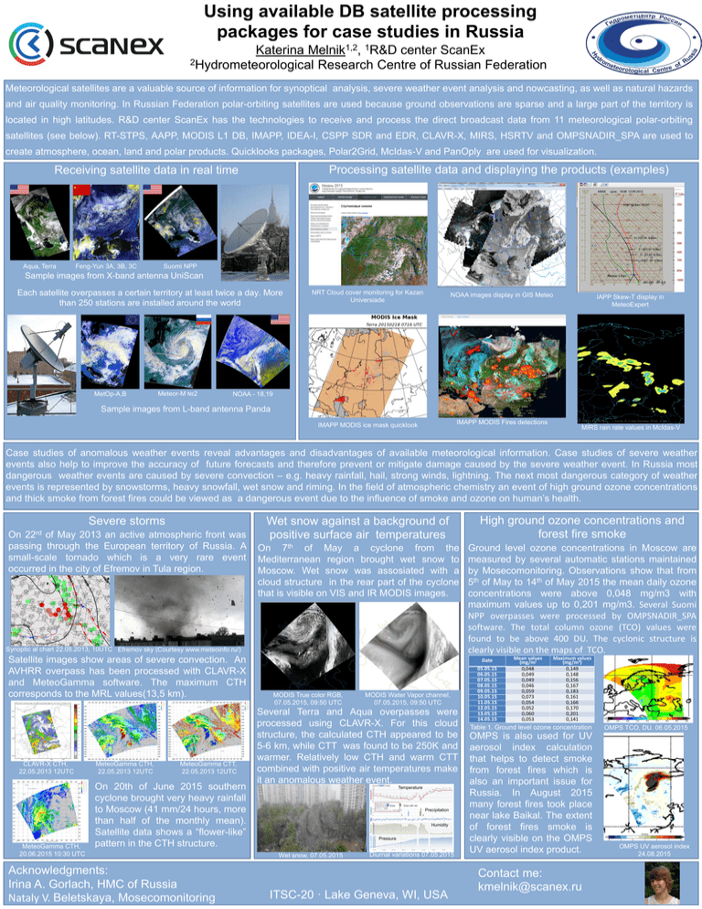
Using available DB satellite processing packages for case studies in Russia 1,2 1 Melnik , R&D Katerina center ScanEx 2Hydrometeorological Research Centre of Russian Federation Meteorological satellites are a valuable source of information for synoptical analysis, severe weather event analysis and nowcasting, as well as natural hazards and air quality monitoring. In Russian Federation polar-orbiting satellites are used because ground observations are sparse and a large part of the territory is located in high latitudes. R&D center ScanEx has the technologies to receive and process the direct broadcast data from 11 meteorological polar-orbiting satellites (see below). RT-STPS, AAPP, MODIS L1 DB, IMAPP, IDEA-I, CSPP SDR and EDR, CLAVR-X, MIRS, HSRTV and OMPSNADIR_SPA are used to create atmosphere, ocean, land and polar products. Quicklooks packages, Polar2Grid, McIdas-V and PanOply are used for visualization. Processing satellite data and displaying the products (examples) Receiving satellite data in real time Aqua, Terra Feng-Yun 3A, 3B, 3C Suomi NPP Sample images from X-band antenna UniScan Each satellite overpasses a certain territory at least twice a day. More than 250 stations are installed around the world MetOp-A,B Meteor-M №2 NRT Cloud cover monitoring for Kazan Universiade NOAA images display in GIS Meteo IMAPP MODIS ice mask quicklook IMAPP MODIS Fires detections IAPP Skew-T display in MeteoExpert NOAA - 18,19 Sample images from L-band antenna Panda MIRS rain rate values in McIdas-V Case studies of anomalous weather events reveal advantages and disadvantages of available meteorological information. Case studies of severe weather events also help to improve the accuracy of future forecasts and therefore prevent or mitigate damage caused by the severe weather event. In Russia most dangerous weather events are caused by severe convection – e.g. heavy rainfall, hail, strong winds, lightning. The next most dangerous category of weather events is represented by snowstorms, heavy snowfall, wet snow and riming. In the field of atmospheric chemistry an event of high ground ozone concentrations and thick smoke from forest fires could be viewed as a dangerous event due to the influence of smoke and ozone on human’s health. Severe storms On 22rd of May 2013 an active atmospheric front was passing through the European territory of Russia. A small-scale tornado which is a very rare event occurred in the city of Efremov in Tula region. Wet snow against a background of positive surface air temperatures High ground ozone concentrations and forest fire smoke On 7th of May a cyclone from the Mediterranean region brought wet snow to Moscow. Wet snow was assosiated with a cloud structure in the rear part of the cyclone that is visible on VIS and IR MODIS images. Ground level ozone concentrations in Moscow are measured by several automatic stations maintained by Mosecomonitoring. Observations show that from 5th of May to 14th of May 2015 the mean daily ozone concentrations were above 0,048 mg/m3 with maximum values up to 0,201 mg/m3. Several Suomi NPP overpasses were processed by OMPSNADIR_SPA software. The total column ozone (TCO) values were found to be above 400 DU. The cyclonic structure is clearly visible on the maps of TCO. Synoptic al chart 22.05.2013, 10UTC Efremov sky (Courtesy www.meteoinfo.ru/) Satellite images show areas of severe convection. An AVHRR overpass has been processed with CLAVR-X and MeteoGamma software. The maximum CTH corresponds to the MRL values(13,5 km). CLAVR-X CTH, 22.05.2013 12UTC MeteoGamma CTH, 20.06.2015 10:30 UTC MeteoGamma CTH, 22.05.2013 12UTC MeteoGamma CTT, 22.05.2013 12UTC On 20th of June 2015 southern cyclone brought very heavy rainfall to Moscow (41 mm/24 hours, more than half of the monthly mean). Satellite data shows a “flower-like” pattern in the CTH structure. Acknowledgments: Irina A. Gorlach, HMC of Russia Nataly V. Beletskaya, Mosecomonitoring Date MODIS True color RGB, 07.05.2015, 09:50 UTC MODIS Water Vapor channel, 07.05.2015, 09:50 UTC Several Terra and Aqua overpasses were processed using CLAVR-X. For this cloud structure, the calculated CTH appeared to be 5-6 km, while CTT was found to be 250K and warmer. Relatively low CTH and warm CTT combined with positive air temperatures make it an anomalous weather event. Temperature Snow Snow with rain Precipitation Humidity Pressure Wet snow, 07.05.2015 Diurnal variations 07.05.2015 ITSC-20 · Lake Geneva, WI, USA 05.05.15 06.05.15 07.05.15 08.05.15 09.05.15 10.05.15 11.05.15 12.05.15 13.05.15 14.05.15 Mean values (mg/m) 0,048 0,049 0,049 0,046 0,059 0,073 0,054 0,052 0,060 0,053 Maximum values (mg/m3) 0,149 0,148 0,156 0,167 0,183 0,161 0,166 0,170 0,201 0,141 Table 1. Ground level ozone concentration OMPS TCO, DU. 06.05.2015 OMPS is also used for UV aerosol index calculation that helps to detect smoke from forest fires which is also an important issue for Russia. In August 2015 many forest fires took place near lake Baikal. The extent of forest fires smoke is clearly visible on the OMPS UV aerosol index product. OMPS UV aerosol index 24.08.2015 Contact me: kmelnik@scanex.ru
