Planning Implementation Tools Adequate Public Facilities Regulations TOOL DESCRIPTION
Planning Implementation Tools
Adequate Public Facilities Regulations
Center for Land Use Education www.uwsp.edu/cnr/landcenter November 2009
TOOL DESCRIPTION
Adequate public facilities (APF) regulations are designed to balance the timing of new development with planned public expenditures such as roads, transit facilities, water and sewer service, and emergency services.
Commonly referred to as a „concurrency‟ requirement, APF regulations condition the approval of new development on a finding that adequate public facilities or services are in place or will be provided within a reasonable time frame to serve the new development. The most effective
APF regulations are closely tied to planned land uses, infrastructure phasing maps, and level of service standards laid out in a community‟s comprehensive plan and capital improvement plan.
COMMON USES
Growth Management
APF regulations are not intended to halt or necessarily slow community growth. Rather, they help a community to manage growth by linking the provision of key public facilities and services to factors such as the density, rate, location, timing and type of new development. APF regulations promote planned, rational, and affordable growth and ensure that a community is not left playing “catch-up” to provide necessary infrastructure or services that are not within the community‟s means.
Capital Facilities Planning
APF regulations work hand-in-hand with capital improvement plans, programs and other facility planning devices. If a jurisdiction‟s schedule for providing capital improvements is not adequate for the proposed development, the project may be denied or deferred until resources are available. Requests for development should alert planners and elected officials to future infrastructure needs and assist in prioritizing projects.
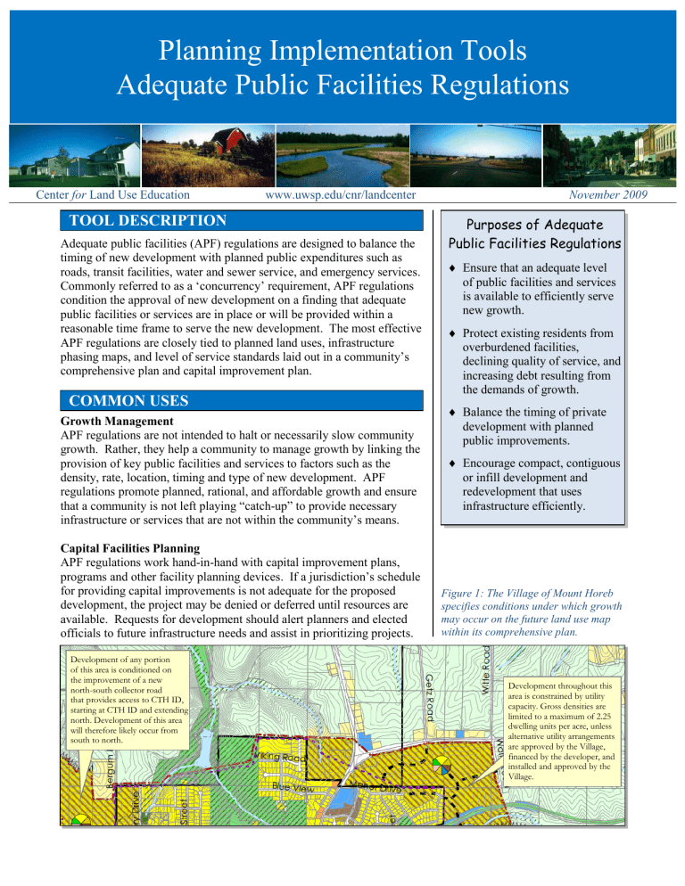
Development of any portion of this area is conditioned on the improvement of a new north-south collector road that provides access to CTH ID, starting at CTH ID and extending north. Development of this area will therefore likely occur from south to north.
Purposes of Adequate
Public Facilities Regulations
Ensure that an adequate level of public facilities and services is available to efficiently serve new growth.
Protect existing residents from overburdened facilities, declining quality of service, and increasing debt resulting from the demands of growth.
Balance the timing of private development with planned public improvements.
Encourage compact, contiguous or infill development and redevelopment that uses infrastructure efficiently.
Figure 1: The Village of Mount Horeb specifies conditions under which growth may occur on the future land use map within its comprehensive plan.
Development throughout this area is constrained by utility capacity. Gross densities are limited to a maximum of 2.25 dwelling units per acre, unless alternative utility arrangements are approved by the Village, financed by the developer, and installed and approved by the
Village.
CREATION
The following APF components may be considered in existing zoning or subdivision regulations or adopted in a stand-alone ordinance:
1.
Public facilities and services. Roads, transit and pedestrian facilities, stormwater facilities, water and sewer service, parks, and emergency services are commonly regulated by APF ordinances.
2.
Level of service (LOS) standard. LOS standards measure the capacity and performance characteristics of a given facility or service.
For example, average daily traffic counts are commonly used to measure the capacity of various road classifications.
3.
Development approval.
The APF regulation should identify the types of development subject to APF findings and the timing of review. Findings are commonly tied to approval of subdivision or condominium plats, certified survey maps, conditional use permits, rezonings, site plans, and building permits. Early review highlights potential deficiencies and helps to avoid unexpected costs late in the process (i.e. preliminary plat vs. final plat or building permit).
Authority
Wisconsin does not have legislation explicitly authorizing APF regulations.
However, state statutes do provide local governments with authority to create subdivision regulations that “facilitate adequate provision for transportation, water, sewerage, schools, parks, playgrounds and other public requirements.”
Furthermore, the state‟s
Comprehensive Planning Law encourages communities to compile “objectives, policies, goals, maps and programs to
ADMINISTRATION
The elected governing body, plan commission, zoning board or staff may be involved in the following project review steps: guide the future development of utilities and community facilities.”
Wis Stats §§ 236.45 and 66.1001
1.
Adequate public facilities determination. Before development can proceed, the applicant must show that existing infrastructure can support projected demand based on the established LOS standards.
2.
Project approval or denial.
Some communities strictly limit approval to projects where facilities are in place or have been budgeted for in the capital improvement plan. Others allow private developers to install or upgrade infrastructure, but may require a development agreement or financial guarantee.
Figure 2: Level of service standards are often assigned a letter grade from A-F.
However, it may not always be desirable to operate at the „A‟ level. As service improves for one facility (vehicle speeds), it may decline for another (bicycle safety). Costs can also be prohibitive when applied across a community. New projects should not be responsible for correcting existing system deficiencies.
Level of Service Standards for Bicycle Access
A/B
Desirable
Dedicated bike lane, at least 4-5 feet in width, with signage, stripes or other markings and a separate sidewalk for pedestrians.
New or recently resurfaced pavement, free of cracks.
Light traffic volume.
Posted speed limit of 25 mph or less.
C/D
Typical
E/F
Undesirable
Paved shoulder or emergency walkway, at least 3 feet in width.
Worn pavement with minor cracks or hazards.
Moderate traffic volume.
Posted speed limit of 25-40 mph.
No bike lane, paved shoulder or sidewalk.
Dangerous cracks, potholes, loose gravel, drainage grates or other hazards.
High traffic volume, including numerous heavy vehicles.
Posted speed limit greater than 40 mph.
Report Card
Cost
Upfront costs, long-term savings
Money or staff resources required to implement the tool.
The cost of impact analyses and other studies to determine whether adequate public facilities are present may be incurred by the local government or passed on to the developer through permit fees. Over the long run, APF regulations can save costs by ensuring that the community is adequately prepared to build and maintain new infrastructure or services.
The public’s positive or negative perception of the tool. Public Acceptance
APF regulations protect existing community members by ensuring that
Public acceptance, private sector concern adequate public infrastructure is in place before new development is allowed to take place. The private sector may become concerned if APF regulations appear to halt growth or shift an unreasonable portion of infrastructure costs to private developers.
Political Acceptance Local officials’ willingness to implement the tool.
Recognize importance, hesitant to adopt
Wisconsin officials seem open to the idea of APF regulations. Many local communities reference APF concerns in comprehensive plans, zoning ordinances and subdivision regulations. Others routinely deny rezonings, subdivision plats, and other development proposals based on “traffic congestion” or other infrastructure shortfalls. Yet, most do so on an ad hoc basis. Very few Wisconsin communities have adopted formal APF regulations that establish targeted service level standards, measure existing capacity, and tie development approval to provision of services. Local officials may be
Equity
Equity concerns if not properly administered
Administration
Adds complexity to development process
Scale
Local government reluctant to cite standards or commit to improvements, fearing that existing service levels are inadequate.
Fairness to stakeholders regarding who incurs costs and consequences.
LOS standards create an objective measure for evaluating the impacts of new development. If utilized correctly, APF regulations provide an efficient tool to address rapid growth and help mitigate problems such as traffic congestion and overburdened infrastructure. If misused, APF regulations can potentially inhibit growth, disproportionately shift the burden of infrastructure improvements to the private sector, and exclude low income households from the market. If a community is unable to implement an effective infrastructure development plan, APF regulations may operate as a de facto moratorium.
Level of complexity to manage, maintain, enforce, and monitor the tool.
APF regulations may increase the complexity of the development process and the cost of processing development proposals. Depending on the type of decision at hand, the elected governing body, plan commission or zoning board may be involved. Staff time is generally also required to review proposals and conduct impact analyses.
The geographic scale at which the tool is best implemented.
APF regulations can be used by cities, villages, towns and counties.
WISCONSIN EXAMPLES
City of Muskego
In October 2003, the City of Muskego amended its zoning and subdivision ordinances to include APF requirements. Prior to obtaining approval for subdivision plats, certified survey maps, conditional use permits, and building site and operation plans, a developer is required to obtain a Certificate of Adequate Public Facilities (CAPF). The CAPF certifies that roads, solid waste facilities, potable water facilities, and stormwater facilities are in place or will be provided within a given time period. Service level standards are based on adopted engineering and design standards found within the municipal code and state statutes. A streamlined certification process is provided for small and low density developments. A waiver may also be granted if the absence of a public facility does not pose a threat to public health or safety.
For more information see the City of Muskego Code of Ordinances,
Chapter 17, Section 5.11 (Zoning) and Chapter 18, Section 18.27
(Land Divisions). www.ci.muskego.wi.us/Portals/11/docs/Codes/
Village of DeForest
The 2006 Village of DeForest Comprehensive Plan contains a number of components that support adequate public facilities. The plan identifies a
„future urban service area boundary‟ and recommends that future utilities only be provided to areas within this boundary. The plan also identifies
„growth phasing areas‟ which are intended to guide the location and timing of new development to areas that can efficiently and cost effectively be served by community facilities, services and infrastructure.
In further support of APF goals, the plan recommends development of level of service standards and continued use of its Capital Improvement
Plan to provide for major utility and community facility needs.
For more information see the Village of DeForest Comprehensive Plan. www.vandewalle.com/work/wipdeforest.html
Figure 3: The Village of DeForest growth phasing map shows desired patterns of development through 2024.
Growth is linked to the provision of public facilities and services projected to occur within the urban service area boundary.
Municipal Boundary
Future Northern Urban
Service Area Boundary
Extraterritorial Jurisdiction
Developed
Growth Phasing Areas:
Phase 1 (through 2013)
Phase 2 (2014-2023)
Phase 3 (2024+)
FOR MORE INFORMATION
White, S. Mark. 1996. Adequate Public Facilities Ordinances and Transportation Management . American
Planning Association, Planning Advisory Service, Report 465.
White, S. Mark and Elisa Paster. Creating Effective Land Use Regulations through Concurrency. Natural
Resources Journal , Vol. 43, No. 3, Summer 2003.
Freilich, Robert H. and S. Mark White, with Kate F. Murray. 2008. 21st Century Land Development Code .
Chicago, IL: APA Planners Press.
ACKNOWLEDGEMENTS
Document prepared by Rebecca Roberts, 2009. The author gratefully acknowledges the review and contributions of Lynn Markham and Linda Stoll, Center for Land Use Education; Gary Korb and Rick Kania,
Southeastern Wisconsin Regional Planning Commission; and Jeff Muenkel, City of Muskego.
Figure 1 map excerpted from the 2005 Mount Horeb Comprehensive Plan, prepared by Vandewalle &
Associates. Figure 2 photos and level of service standards adapted from the 2009 Quality/Level of Service
Handbook, prepared by the Florida Department of Transportation. Figure 3 map excerpted from the 2006
Village of DeForest Comprehensive Plan, prepared by Vandewalle & Associates.
