Evaluating Sedimentation Risks Associated With Fuel Management Fuels Planning: Science Synthesis and Integration
advertisement

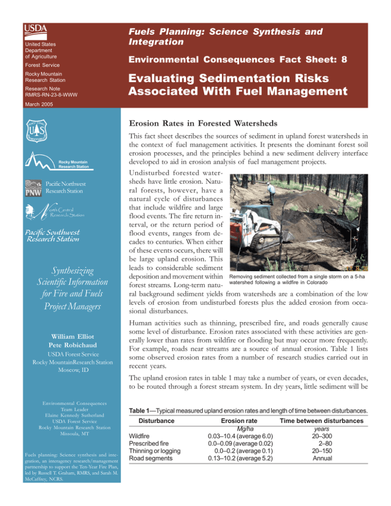
Fuels Planning: Science Synthesis and Integration United States Department of Agriculture Forest Service Rocky Mountain Research Station Research Note RMRS-RN-23-8-WWW Environmental Consequences Fact Sheet: 8 Evaluating Sedimentation Risks Associated With Fuel Management March 2005 Erosion Rates in Forested Watersheds Rocky Mountain Research Station Pacific Northwest Research Station Synthesizing Scientific Information for Fire and Fuels Project Managers William Elliot Pete Robichaud USDA Forest Service Rocky MountainResearch Station Moscow, ID Environmental Consequences Team Leader Elaine Kennedy Sutherland USDA Forest Service Rocky Mountain Research Station Missoula, MT Fuels planning: Science synthesis and integration, an interagency research/management partnership to support the Ten-Year Fire Plan, led by Russell T. Graham, RMRS, and Sarah M. McCaffrey, NCRS. This fact sheet describes the sources of sediment in upland forest watersheds in the context of fuel management activities. It presents the dominant forest soil erosion processes, and the principles behind a new sediment delivery interface developed to aid in erosion analysis of fuel management projects. Undisturbed forested watersheds have little erosion. Natural forests, however, have a natural cycle of disturbances that include wildfire and large flood events. The fire return interval, or the return period of flood events, ranges from decades to centuries. When either of these events occurs, there will be large upland erosion. This leads to considerable sediment deposition and movement within Removing sediment collected from a single storm on a 5-ha forest streams. Long-term natu- watershed following a wildfire in Colorado ral background sediment yields from watersheds are a combination of the low levels of erosion from undisturbed forests plus the added erosion from occasional disturbances. Human activities such as thinning, prescribed fire, and roads generally cause some level of disturbance. Erosion rates associated with these activities are generally lower than rates from wildfire or flooding but may occur more frequently. For example, roads near streams are a source of annual erosion. Table 1 lists some observed erosion rates from a number of research studies carried out in recent years. The upland erosion rates in table 1 may take a number of years, or even decades, to be routed through a forest stream system. In dry years, little sediment will be Table 1—Typical measured upland erosion rates and length of time between disturbances. Disturbance Wildfire Prescribed fire Thinning or logging Road segments Erosion rate Mg/ha 0.03–10.4 (average 6.0) 0.0–0.09 (average 0.02) 0.0–0.2 (average 0.1) 0.13–10.2 (average 5.2) Time between disturbances years 20–300 2–80 20–150 Annual routed. In wetter years, considerable amounts of sediment may be delivered to, routed through, and delivered from forest streams. Calculating Long-Term Effects The values in table 1 can be used to compare long-term average annual effects of disturbances by dividing the sediment delivered from the disturbance by the time between disturbances. The fraction of the watershed in roads also has to be determined to complete the analysis. Table 2 gives an example of such calculations. The amount of roads in a watershed can often be expressed as total kilometers of road per square kilometer of watershed, or a percent of the surface of the watershed. A typical value is around 2.5 percent. Times between disturbances that are typical of the Northern Rocky Mountains are also given in table 2. The variables in the table depend on soil properties, topography, disturbance, and climate. Sediment delivery rates may also be lower if improved practices—such as minimizing onsite disturbance, optimizing timing of activities, or using buffers— are used. Table 2—Calculations of long-term average annual effects of disturbances. Disturbance Wildfire Prescribed fire Thinning or logging Road segments (assuming 2.5% of watershed) Erosion rate Time between disturbances Average annual sediment delivery Mg/ha 6.0 0.02 0.10 years 40 20 20 Mg/ha 0.15 0.001 0.005 0.125 1 0.125 Environmental Consequences Fact Sheets Look for fact sheet topics from the Environmental Consequences Team including information about the effects of fire behavior and alternative treatment strategies, Wildlife Response Model, weed responses, riparian systems, soil erosion, restoration objectives, treated spaces, the Fire Effects Information System (FEIS), and the First Order Fire Effects Model (FOFEM). A Tool for Planners and Managers The tool WEPP Fuel Management interface (WEPP: FuMe) specifically aids in predicting sediment delivery values as given in table 2. It is online at http://forest. moscowfsl.wsu.edu/fuels/ Selected References Covert, S. A.; Robichaud, P. R.; Elliot, W. J.; Link, T. E. [In review]. Accuracy assessment of WEPP-based erosion models for harvested and burned forest watersheds. Moscow, ID: U.S. Department of Agriculture, Forest Service, Rocky Mountain Research Station. Foltz, R. B. 1996. Traffic and no-traffic on an aggregate surfaced road: sediment production differences. In: Proceedings of the seminar on environmentally sound forest roads and wood transport; 1996 June 17–22; Sinaia, Romania. Rome: FAO: 195–204. Luce, C. H.; Black, T. A. 2001. Spatial and temporal patterns in erosion from forest roads. In: Wigmosta, M. A.; Burges, S. J., eds. Influence of urban and forest land uses on the hydrologic-geomorphic responses of watersheds. Water Resources Monographs. Washington, DC: American Geophysical Union: 165–178. MacDonald, G. I.; Harvey, A. E.; Tonn, J. R. 1999. Fire, competition and forest pests: landscape treatment to sustain ecosystem function. In: Neuenschwander, L. F.; Ryan, K. C., eds. The joint fire science conference and workshop; 1999 June 15–17; Boise, ID. [Online]. http:/ /www.nifc.gov/joint_fire_sci/conferenceproc/ [January 2005]. Fuels Planning: Synthesis and Integration This fact sheet is one in a series being produced as part of a larger project supported by the USDA Forest Service to synthesize new knowledge and information relevant to fire and fuels management. Fact sheets address topics related to stand structure, environmental impacts, economics, and human responses to these factors. Information in the fact sheets is targeted for the dry forests of the Inland West, but is often applicable across broad regions of the country. For more information, please visit our Web site at: www.fs.fed.us/fire/tech_transfer/synthesis/synthesis_index The Fuels Planning fact sheets are based on preliminary findings. Information from fact sheets will be synthesized in an upcoming publication.


