SATELLITE OBSERVATIONS OF GLACIER ADVANCES AND RETREAT IN THE WESTERN KARAKORAM GC41A-0089
advertisement

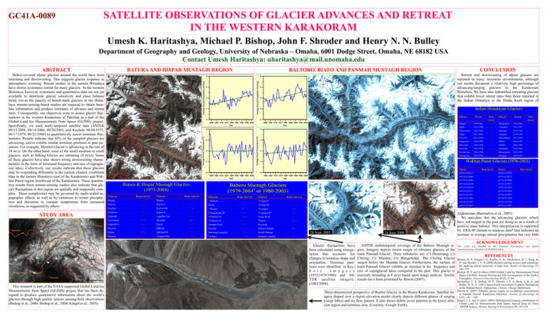
GC41A-0089 SATELLITE OBSERVATIONS OF GLACIER ADVANCES AND RETREAT IN THE WESTERN KARAKORAM Umesh K. Haritashya, Michael P. Bishop, John F. Shroder and Henry N. N. Bulley Department of Geography and Geology, University of Nebraska – Omaha, 6001 Dodge Street, Omaha, NE 68182 USA Contact Umesh Haritashya: uharitashya@mail.unomaha.edu Retreat and downwasting of alpine glaciers are reported in many mountain environments, although our results document a relatively high percentage of advancing/surging glaciers in the Karakoram Himalaya. We have also indentified retreating glaciers that exhibit lower retreat rates than those reported in the Indian Himalaya or the Hindu Kush region of Average Annual Precipitation (mm/day) 8 3 2 1 0 6 4 2 0 1960 1965 1970 1975 1980 1985 1990 1995 2000 Year 1960 1965 1970 1975 1980 1985 1990 1995 2000 Year 2 Average Annual Temperature (OC) -4 -5 -6 -7 -8 1 0 -1 -2 1960 1965 1970 1975 1980 1985 1990 1995 2000 Year 1960 1965 1970 1975 1980 1985 1990 1995 2000 Year 1 1 STUDY AREA 2 2 4 20 Sept. 2003 This research is part of the NASA-supported Global Land Ice Measurements from Space (GLIMS) project that has been designed to produce quantitative information about the world’s glaciers through high quality remote sensing/field observations (Bishop et al., 2000; Bishop et al., 2004; Kargel et al., 2005). CONCLUSION BALTORO, BIAFO AND PANMAH MUSTAGH REGION 4 Average Annual Precipitation (mm/day) Debris-covered alpine glaciers around the world have been retreating and downwasting. This suggests glacier response to atmospheric warming. Recent studies in the eastern Himalaya have shown systematic retreat for many glaciers. In the western Himalaya, however, systematic and quantitative data are not yet available to determine glacier sensitivity and mass balance trend. Given the paucity of bench-mark glaciers in the Himalaya, remote-sensing-based studies are required to obtain baseline information and produce estimates of advance and retreat rates. Consequently, our objectives were to assess glacier fluctuations in the western Karakoram of Pakistan as a part of the Global Land Ice Measurements from Space (GLIMS) project. Specifically, we used multi-temporal satellite data (ASTER 09/13/2004, 08/14/2004, 09/20/2003, and Keyhole 08/04/1973, 06/17/1979, 06/22/1980) to quantitatively assess terminus fluctuations. Results indicate that 45% of the sampled glaciers are advancing, and/or exhibit similar terminus positions to past positions. For example, Momhil Glacier is advancing at the rate of 10 m/yr. On the other hand, most of the small-medium to small glaciers, such as Silking Glacier are retreating (4 m/yr). Some of these glaciers have also shown strong downwasting characteristics in the form of increased frequency and size of supraglacial lakes. Collectively, our results indicate that these glaciers may be responding differently to the current climatic conditions than in the eastern Himalaya (east of the Karakoram) and Wakhan Pamir region (northwest of the Karakoram). These quantitative results from remote-sensing studies also indicate that glacier fluctuations in this region are spatially and temporally complex. These complexities may be governed by multi-scaled topographic effects, as well as by variations in winter precipitation and decreases in summer temperature from increased cloudiness, as suggested by others. BATURA AND HISPAR MUSTAGH REGION Average Annual Temperature (OC) ABSTRACT Glacier fluctuations have been calculated using triangulation that accounts for changes in terminus shape and orientation. Terminus positions were identified in Keyh o l e i m a g e r y (1973/1979/1980) and ASTER satellite imagery. (2003/2004). 3 4 3 24 June 2006 ASTER multitemporal coverage of the Baltoro Mustagh region. Imagery depicts recent surges of tributary glaciers of the main Panmah Glacier. These tributaries are: (1) Drenmang; (2) Chiring; (3) Maedan; (4) Shingchukpi. The Chiring Glacier surged before the Maedan Glacier. Furthermore, the surface of main Panmah Glacier exhibits an increase in the frequency and size of supraglacial lakes compared to the past. This glacier is currently retreating at 6 m/yr based upon image analysis. Similar results have been presented by Hewitt (2007). Three-dimensional perspective of Bualtar Glacier in the Hunza Karakoram. Satellite imagery draped over a digital elevation model clearly depicts different phases of surging (surge lobes) and ice flow pattern. It also shows debris cover patterns in the lower ablation region and terminus area. (Courtesy: Google Earth). Afghanistan (Haritashya et al., 2007). We speculate that the advancing glaciers, which have not surged in the past are doing so as a result of positive mass balance. This interpretation is supported by ERA-40 climate re-analysis data* that indicates an increase in average annual precipitation but very little ACKNOWLEDGEMENT The work was funded by the National Aeronautics and Space Administration (NASA) (NNG04GL84G). REFERENCES Bishop, M. P., Kargel, J. S., Kieffer, H. H., MacKinnon, D. J., Raup, B. H. and Shroder, J. F., Jr (2000) Remote-sensing science and technology for studying glacier processes in high Asia. Annals of Glaciology 31, 164–170. Bishop, M. P. and 16 others (2004) Global Land-Ice Measurements From Space (GLIMS): Remote Sensing and GIS Investigations of the Earth’s Cryosphere. Geocarto International 19 (2), 57-84. Haritashya, U. K, Bishop, M. P., Shroder, J. F. Jr, Bush, A. B. G. and Bulley, H. N. N. (2007) Space-based assessment of glacier fluctuations in the Wakhan Pamir, Afghanistan. Climatic Change (Submitted). Hewitt, K. (2007) Tributary glacier surges: an exceptional concentration at Panmah Glacier, Karakoram Himalaya. Journal of Glaciology 53 (181), 181—188. Kargel, J. S. and 16 others (2005) Multispectral Imaging contributions to Global Land Ice Measurements from Space, Special Issue on Terra/ ASTER Science. Remote Sensing of Environment 99, 187-219


