GRAPHICAL REPRESENTATION OF AN ARMENIAN ... M. Kempa, M. Sehlüter
advertisement
GRAPHICAL REPRESENTATION OF AN ARMENIAN CASTLE WITH AUTOCAD
M. Kempa, M. Sehlüter
Institute of Photogrammetry and Cartography, TH Darmstadt l FRG
ISPRS Congress, Com. V, Washington 1992
ABSTRACT
In
order to preserve and restore an Armenian monument ,- at
the moment a ruin and heavily demaged by earthquakes
a
measurement eampaign was done in ArmeniajUSSR initiated and
supported by German and Armenian eurators of monuments . Caused by
the speeific locality photogrammetrie and geodetic (tachymetrie)
maesurements had to be combined for the task: graphical maps
(plan-, . side views etc.) for following static calculations. In
order to enable the processing of both types of raw-data AutoCAD
was chosen as' graphie tool. This resul ted in a more flexible
handling of the input. Data processing, results and the advantages
of the chosen procedure are presented.
.
KEYWORDS
Architectural, CADjCAM, Terrestrial, Visualization
THE ARCHITECTURAL MONUMENT
INITIATIVE, PARTICIPANTS AND CLAIMS
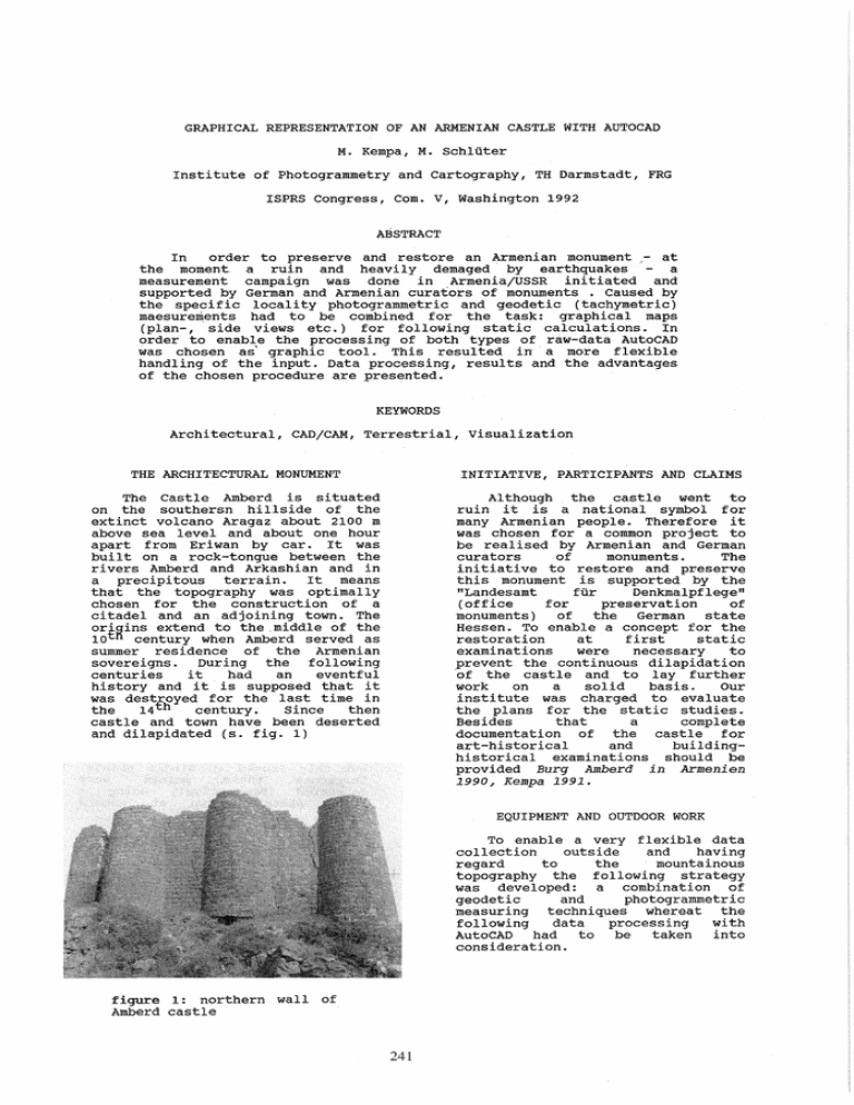
The Castle Amberd is situated
on the southersn hillside of the
extinct voleano Aragaz about 2100 m
above sea level and about one hour
apart from Eriwan by ear. It was
built on a roek-tongue between the
ri vers Amberd and Arkashian and in
a precipitous terrain.
It me ans
that the topography was optimally
chosen for the construetion of a
citadel and an adjoining town. The
ori~ins extend to the .middle of the
10 tfi century when Amberd served as
summer residence of the Armenian
sovereigns.
During the following
centuries
it
had
an
eventful
history and it is supposed that it
was destroyed for the last time in
the
14 th
century.
Since
then
eastle and town have been deserted
and dilapidated (s.
. 1)
Although the castle want to
ruin it is a national symbol for
many Armenian people. Therefore it
was chosen for a common project to
be realised by Armenian and German
eurators
of
monuments.
The
initiative to res tore and preserve
this monument is supported by the
"Landesamt
für
Denkmalpflege"
(office
for
preservation
of
monuments)
of the German state
Hessen. To enable a concept for the
restoration
at
first
statie
examinations
were
necessary
to
prevent the continuous dilapidation
·of the castle and to lay further
work
on
a
solid
basis.
Our
institute was charged to evaluate
the plans for the static studies.
Besides
that
a
complete
documentation of the castle for
art-historical
and
buildinghistorical examinations should be
provided Burg Amberd in Armenien
1990, Kempa 1991.
EQUIPMENT AND OUTDOOR WORK
To enable a very flexible data
eollection
outside
and
having
regard
to
the
mountainous
topography the following strategy
was developed: a eombination of
geodetic
and
photogrammetric
measuring teehniques whereat the
following
data
processing
with
AutoCAD
had
to
be
taken
into
eonsideration.
figura 1: northern wall of
Amberd castle
241
required
entities
containing
different types of lines which were
supplied with different keys due to
their information (e.g.
profile,
detai 1 , contour). It was attached
importance to get all
relevant
information
(line)
simultaneously
evaluating a model. After having
finished this the raw-data for the
following processing with AutoCAD
were
given
in
a
homogeneous
coordinate system.
Therefore
the
following
measuring instruments were used: an
electronic
tachymeter
(ELTA
2)
combined
with
an
electronic
interface (REC 500) and a small
plotter, and a (non-metric) survey
camera (ROLLEIFLEX SLX) with a 50
and 80 mm lens. The potential of
this type of photogrammetric camera
was often used for architectural
tasks, e. g . stephani M., Eder K.
1987, wester-Ebbinghaus W.
1983.
This
equipment
offered
a
high
measurement
comfort
and
considerably
facilitated
the
outdoor work.
DATA PROCESSING WITH AUTOCAD
A brief look at the literature
shows that AutoCAD is more and more
used
for
the
graphical
representation
of
photogrammetrically derived data, e.g.
Belli A. 1990, Heine E. et ale
1990, stevens D., Me Kay W.
M.
1990.
The
advantage
of
this
procedure is that da ta sets of
different origin can be combined.
The
user
has
also
a
lot
of
utilities
for
visualisation
available
and
the
exploitations
were done on a graphie monitor.
The determination of control
points was carried out by polygons
for the outside walls and the
interior area of the the castle.
The
differences
in
elevation
between these two parts (about 25
meters) and bad sights rendered
this work rather difficult. In some
parts also tachymetrie measurements
were carried out for further data
processing in order to minimize the
expense of raw-data collection.
Before
transfering
and
integrating the da ta into AutoCAD a
preprocessing had to be carried out
with
regard
to
the
following
aspects:
The photogrammetric work can be
di vided into two parts: all walls
were covered by terrestrial camera
stations
and
in
addi tion
especially for the interior area aerial photographs were taken using
a helicopter of Aeroflot.
connection
of
line
segments
belonging together deri ved from
different models
combination of data sets which
belong to one plot
PHOTOGRAMMETRIC TASKS AND DATA
PROCESSING
transformation of the lines into
the right projection plane
The photogrammetric tasks were
gi ven ei ther by the object and the
desired result. Because a mapping
of
the
borders
of
the
stones
principally
had to be guaranteed,
the image scale should not be less
then
1: 300 , a n d for
a
better
visibility color images were taken.
The
accuracy
of
the
graphical
representation should be in the
range of 0.05-0.1 m.
This was
achieved for both mentioned types
of photo coverage. It must be added
that the calculations containing
aerial
photographs
had
worse
accuracy because of movement blurs.
cleaning of the data
This steps were finished with
the conversion of the data into the
DXF-format which means a
"data
exchange format" for in- and output
data for AutoCAD ( s . AutoCAD User
Guide). The tachymetrie da ta were
already given in the DXF-format,
but only stored as single points.
Therefore
these
points
were
connected
interactively using
a
rough
sketch
drawn
at
Amberd
castle.
For
the
postprocessing
different information was put into
varying layers to enable to fade
da ta
in
or
out
due
to
the
respective task. Thus the input
could
be
controlled
by
e.g.
superimposing a front view with the
vertical profiles of a wall.
The
graphical representation could be
varied by signature, colour or area
filling if necessary. The result
should
be
an
easily
readable
representaion
of
the
entire
information (in fig. 2 an overview
of all plans is depicted).
The number of control points
was restricted to 6 points per
wall, because after sorting and
ordering all pictures at first for
almost each sight of wall the
number
of
control
points
was
increased
by
bundle
block
adjustment
Düppe
R.
D.
1984.
Afterwards
stereosscopic
models
were evaluated with an analytical
plotter
(Wild
AC1).
The
data
collection was carried out due to
242
AMBERD
Looking at the costs for hardand software ,it can be remarked
that
compared wi th analytical
plotters with a (rather) low cost
equipment
(in
principle:
a
coordinate-measuring
machine,
personal computer and agraphie
tool) the evaluation of plans
using
photogrammetric
techniques
and restricting to a less accuracy
- for architects can be enabled.
GeS0MtueberSiC,ht
r--------r--,-----T~"-----T~=- _ _ _;=:p___------,130
I
120
+',
-'
~i.;.","
+
"-
/'"",
~.
120
110
110
As
mentioned
above
perhaps
further
exploitation
of
the
existing data (i.e. photos, more
detailed
information
extraction)
will be done, because for carrying
out the restoration an inventory of
stones is needed. To get such an
inventory varying procedures are
possible: supply of the existing
plans with orthophotos or mapping
of the borders of stones of all
walls using stereo models again.
The first strategy is problematic,
because
for
an
opto-mechanical
rectification the inclination of
almost all photos is too strong and
could be only achieved step by
step. On the other hand a detailed
mapping of the borders of stones is
very
time
consuming.
Therefore
another solution seems to be more
attractive: digitization of those
parts of the images which are
needed
and
then
digital
rectification with control points.
The digital orthophotos now can be
used to extract edges ( of stones)
applying methods of digital image
processing. First experiments were
carried out within the framewor~ of
practical studies for students last
year and yielded good results.
100
Cl
Cl
lJoo!r l:t"pnotogro)lYI4't r ''Jch
UP!rISS to.chy_tri1ich
Schnltt.,/PrQjI'ktlon.,..twnlP
TH D01"r'lS t0cH
Inst",tu1
PhotogrorH'1etr;e und
150
figura 2: ground section and
overview of evaluated plans
RESULTS, CONCLUSIONS AND OUTLOOK
For the southern wall of the
castle all plans are exemplarily
performed in fig. 3-5. In the front
view one can see that in some parts
evaluation of details (e.g. the
window
embrasures)
were
carried
out.
The chosen procedure offers the
advantage the that after collection
and preprocessing in principal any
desired kind of representaion or
combination
of
the
da ta
is
possible. This is very important if
one has to cooperate wi th experts
with
different
professional
background
( e .. g ..
archi tects I
statical engineers): in that cases
the aimed density of information
and its representationnot always
are apriori definitely fixed. In
addi tion one has to take into
account the amount of data.
AMBERD
2170
,.'
+
+
'
I"
,+
+
:q DU
,:'1;
/:j
Suedwon~
Ansicht
+
2170
lOH
r . ,n -;y: -- Ti 1Jr --:i! -ur1: '"~-:- ----: -; ~~ -[J -: ~-!"l-l-
x I' :
2160
I
+
,
i
,";,
+ : ij+
+
I
.:
+
'
,
2160
o
A further aspect is given by
the fact that in the area of
architecture
the
application of
AutoCAD
is
now
rather
widely
spread. An exchange of graphical
da ta and their further procesing
under
more
art-historical
or
building-historical approaches is
thus very easily possible.
Cl
Tf-I
Institut
M
=
1
~ v<pr
D0r'~Stodt
PhotogrOl""lr'letr,e und KartographiE"
100
figure 3: front view of the
southern
wall
(with
addi tional
information of
the backside)
243
AMBERD
0
0
120 0
115
+'
'Ei
~
~
~
+
+
+
115
-l.-,
110
110
~
105
~ - - _: ~
100
t
:
0
0
~
t
I
w
95
Mrs.
Anastasiadou,
carried
out
photogrammetric
evaluation,
Horizonto.lschnitt Suedwo.nd X
Mr.
Krauth,
who transfered
the data into AutoCAD and
performed
the
graphical
representation,
Mr. peipe from the Institute
of Photogrammetry, University
of
German
Federal
Armed
Forces
(Munich,
FRG) ,
for
making the camera available
to uso
105
100
95
~
~
~
~
0
who
the
model
TH Do.rMsto.oIt
t,Ntssphot'ogro_tr-'SCh
!JIorblst.chyN'trlsch
Institut fuer
PhotograMMetrie und Kartographie
ScMItW"'"Jl'ktlOfl~
REFERENCES
M
=
1
Z = 2164.9
100
AutoCAD Release 11, 1990.
Reference, Autodesk AG.
figure 4: ground section of
the southern wall
Belli A., 1990. Large-scale
stereophotogrammetric survey
and computer data processing on
particular works of art. ISPRS
Vol. 28, B 5/1, Zürich: 42-50.
Burg Amberd in Armenien, 1990.
sanierungskonzept. Sonderheft
des
Landesamts für
Denkmalpflege (Hessen),
Wiesbaden (unpublished).
AMBERD Vertiko.lschnitte Suedwo.nd
~
LLJO
A - B
2170
2170
2170
Düppe R. D., 1984. Kombinierte
Ausgleichung in der
photogrammetrie:
Programmkonzeption und
Beispiele. ISPRS Vol. 25, B 3a,
Comm. III, Rio de Janeiro: 117129.
{!
2165
I:' ----11
2165
2160
2160
2160
=- tl
-I
2160
:= -."
f
2165
2160
=:~ _L_
o
U1
0
o
0
U1
- _. _. -
lJAr"itI.<pf1ot. .O...... V'sch)
-
- _1_--
2155
2155
.......20f1t.lsctwtt/ProjlPkt5001H'1rW1W
D
D
U1
o
2155
Heine E., Kostka R., Reiter A.,
1990. Main Palace of Santa
Rosa: XTAMPAK a geodeticphotogrammetric documentation.
ISPRS Vol. 28, B 5/1, Zürich:
67-76.
0
U1
TH Do.rMsto.oIt
Institut fuer
PhotograMMetrie und Kartographie
M = 1 : 100
Kempa M., 1991. photogrammetrische
Aufnahme von Burg Amberd
(Armenien, UdSSR). ZPF 59(3):
103-104.
figure 5: vertical profiles
of the southern wall
stephani M., Eder K., 1987.
Leistungspotential einer
Teilmeßkammer beim Einsatz in
der Architekturphotogrammetrie.
BuL 55(5): 204-213.
stevens D., Mc Kay W. M., 1990.
Combined use of photogrammetry
and CAD in the reconstruction
of fire-damaged buildings.
ISPRS Vol. 28, B 5/1, Zürich:
77-85.
ACKNOWLEDGMENTS
The authors sincerly thank:
All Armenien people, who took
care of us, especially Viktor
and Suren f who supported our
work at Amberd castle,
Wester-Ebbinghaus W., 1983. Ein
photogrammetrisches System für
Sonderanwendungen. BuL 51(1):
118-128.
244
