Appendix B: – NLCD Crosswalk Wiscland:
advertisement
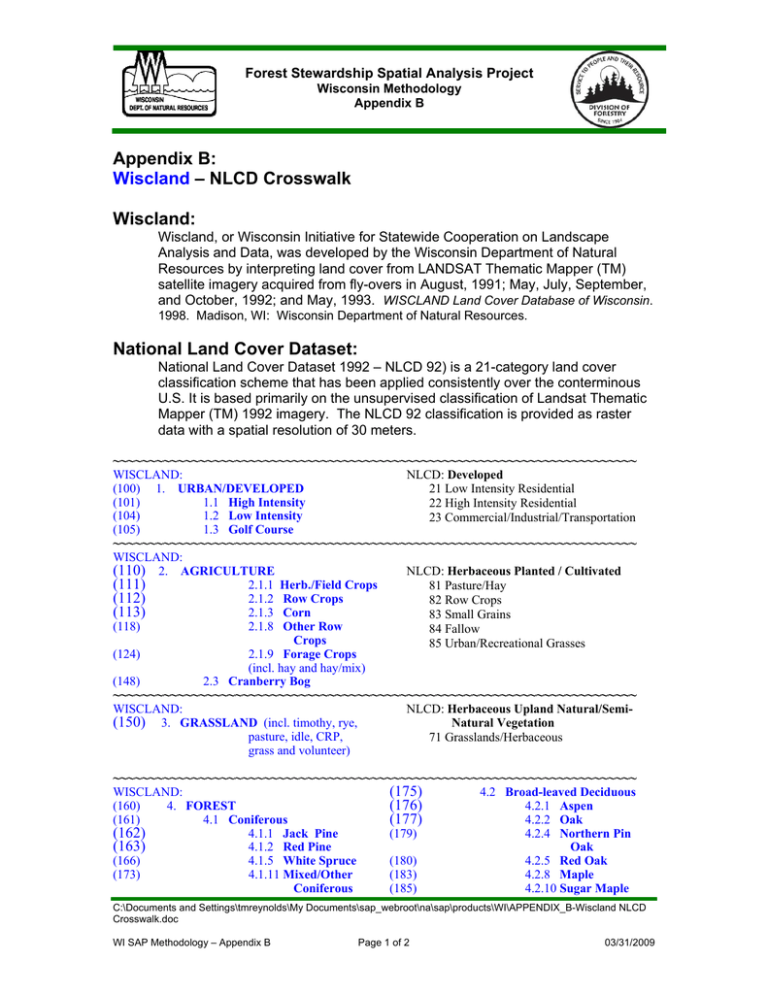
Forest Stewardship Spatial Analysis Project Wisconsin Methodology Appendix B Appendix B: Wiscland – NLCD Crosswalk Wiscland: Wiscland, or Wisconsin Initiative for Statewide Cooperation on Landscape Analysis and Data, was developed by the Wisconsin Department of Natural Resources by interpreting land cover from LANDSAT Thematic Mapper (TM) satellite imagery acquired from fly-overs in August, 1991; May, July, September, and October, 1992; and May, 1993. WISCLAND Land Cover Database of Wisconsin. 1998. Madison, WI: Wisconsin Department of Natural Resources. National Land Cover Dataset: National Land Cover Dataset 1992 – NLCD 92) is a 21-category land cover classification scheme that has been applied consistently over the conterminous U.S. It is based primarily on the unsupervised classification of Landsat Thematic Mapper (TM) 1992 imagery. The NLCD 92 classification is provided as raster data with a spatial resolution of 30 meters. ~~~~~~~~~~~~~~~~~~~~~~~~~~~~~~~~~~~~~~~~~~~~~~~~~~~~~~~~~~~~~~~~~~~~~~~~~ WISCLAND: (100) 1. URBAN/DEVELOPED (101) 1.1 High Intensity (104) 1.2 Low Intensity (105) 1.3 Golf Course NLCD: Developed 21 Low Intensity Residential 22 High Intensity Residential 23 Commercial/Industrial/Transportation ~~~~~~~~~~~~~~~~~~~~~~~~~~~~~~~~~~~~~~~~~~~~~~~~~~~~~~~~~~~~~~~~~~~~~~~~~ WISCLAND: (110) 2. AGRICULTURE (111) 2.1.1 (112) 2.1.2 (113) 2.1.3 (118) 2.1.8 (124) (148) Herb./Field Crops Row Crops Corn Other Row Crops 2.1.9 Forage Crops (incl. hay and hay/mix) 2.3 Cranberry Bog NLCD: Herbaceous Planted / Cultivated 81 Pasture/Hay 82 Row Crops 83 Small Grains 84 Fallow 85 Urban/Recreational Grasses ~~~~~~~~~~~~~~~~~~~~~~~~~~~~~~~~~~~~~~~~~~~~~~~~~~~~~~~~~~~~~~~~~~~~~~~~~ WISCLAND: (150) 3. GRASSLAND (incl. timothy, rye, pasture, idle, CRP, grass and volunteer) NLCD: Herbaceous Upland Natural/SemiNatural Vegetation 71 Grasslands/Herbaceous ~~~~~~~~~~~~~~~~~~~~~~~~~~~~~~~~~~~~~~~~~~~~~~~~~~~~~~~~~~~~~~~~~~~~~~~~~ WISCLAND: (160) 4. FOREST (161) 4.1 Coniferous (162) 4.1.1 Jack Pine (163) 4.1.2 Red Pine (166) 4.1.5 White Spruce (173) 4.1.11 Mixed/Other Coniferous (175) (176) (177) (179) (180) (183) (185) 4.2 Broad-leaved Deciduous 4.2.1 Aspen 4.2.2 Oak 4.2.4 Northern Pin Oak 4.2.5 Red Oak 4.2.8 Maple 4.2.10 Sugar Maple C:\Documents and Settings\tmreynolds\My Documents\sap_webroot\na\sap\products\WI\APPENDIX_B-Wiscland NLCD Crosswalk.doc WI SAP Methodology – Appendix B Page 1 of 2 03/31/2009 Forest Stewardship Spatial Analysis Project Wisconsin Methodology Appendix B (187) 4.2.12 Mixed/Other Broad-leaved Deciduous (190) 4.3 Mixed Deciduous/ Coniferous NLCD: Forested Uplands 41 Deciduous Forest 42 Evergreen Forest 43 Mixed Forest ~~~~~~~~~~~~~~~~~~~~~~~~~~~~~~~~~~~~~~~~~~~~~~~~~~~~~~~~~~~~~~~~~~~~~~~~~ WISCLAND: (200) 5. OPEN WATER NLCD: Open Water 11 Open Water 12 Perennial Ice/Snow ~~~~~~~~~~~~~~~~~~~~~~~~~~~~~~~~~~~~~~~~~~~~~~~~~~~~~~~~~~~~~~~~~~~~~~~~~ WISCLAND: (210) 6. WETLAND (211) 6.1 Emergent/Wet Meadow (212) 6.1.1 Floating Aquatic Herbaceous Vegetation (217) 6.2 Lowland Shrub (218) 6.2.1 Broad-leaved Deciduous (219) 6.2.2 Broad-leaved Evergreen (220) 6.2.3 Needle-leaved (222) 6.3 Forested (223) 6.3.1 Broad-leaved Deciduous (229) 6.3.6 Coniferous (234) 6.3.10 Mixed Deciduous/ Coniferous NLCD: Wetlands 91 Woody Wetlands 92 Emergent Herbaceous Wetlands ~~~~~~~~~~~~~~~~~~~~~~~~~~~~~~~~~~~~~~~~~~~~~~~~~~~~~~~~~~~~~~~~~~~~~~~~~ WISCLAND: (240) 7. BARREN NLCD: Barren 31 Bare Rock/Sand/Clay 32 Quarries/Strip Mines/Gravel Pits 33 Transitional ~~~~~~~~~~~~~~~~~~~~~~~~~~~~~~~~~~~~~~~~~~~~~~~~~~~~~~~~~~~~~~~~~~~~~~~~~ WISCLAND: (250) 8. SHRUBLAND NLCD: Shrubland 51 Shrubland ~~~~~~~~~~~~~~~~~~~~~~~~~~~~~~~~~~~~~~~~~~~~~~~~~~~~~~~~~~~~~~~~~~~~~~~~ NLCD: Non-natural Woody 61 Orchards/Vineyards/Other ~~~~~~~~~~~~~~~~~~~~~~~~~~~~~~~~~~~~~~~~~~~~~~~~~~~~~~~~~~~~~~~~~~~~~~~~~ (255) 9. CLOUD COVER C:\Documents and Settings\tmreynolds\My Documents\sap_webroot\na\sap\products\WI\APPENDIX_B-Wiscland NLCD Crosswalk.doc WI SAP Methodology – Appendix B Page 2 of 2 03/31/2009

