************ Images not accurately scanned *****************
advertisement
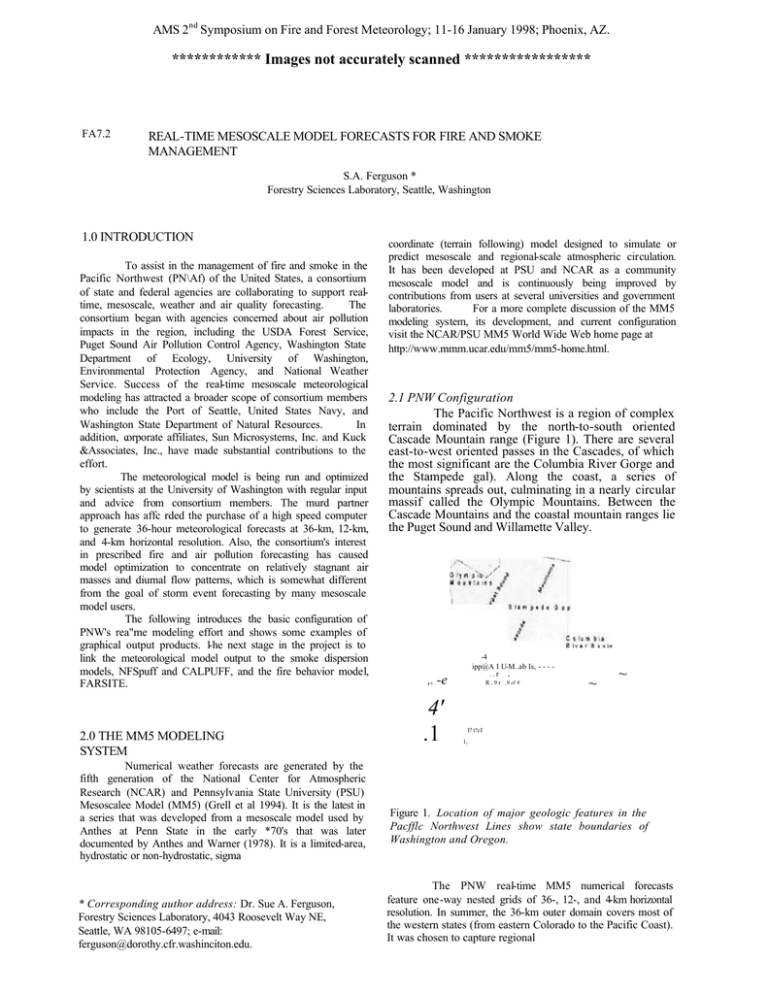
AMS 2nd Symposium on Fire and Forest Meteorology; 11-16 January 1998; Phoenix, AZ. ************ Images not accurately scanned ***************** FA7.2 REAL-TIME MESOSCALE MODEL FORECASTS FOR FIRE AND SMOKE MANAGEMENT S.A. Ferguson * Forestry Sciences Laboratory, Seattle, Washington 1.0 INTRODUCTION To assist in the management of fire and smoke in the Pacific Northwest (PN\Af) of the United States, a consortium of state and federal agencies are collaborating to support realtime, mesoscale, weather and air quality forecasting. The consortium began with agencies concerned about air pollution impacts in the region, including the USDA Forest Service, Puget Sound Air Pollution Control Agency, Washington State Department of Ecology, University of Washington, Environmental Protection Agency, and National Weather Service. Success of the real-time mesoscale meteorological modeling has attracted a broader scope of consortium members who include the Port of Seattle, United States Navy, and Washington State Department of Natural Resources. In addition, corporate affiliates, Sun Microsystems, Inc. and Kuck &Associates, Inc., have made substantial contributions to the effort. The meteorological model is being run and optimized by scientists at the University of Washington with regular input and advice from consortium members. The murd partner approach has affc rded the purchase of a high speed computer to generate 36-hour meteorological forecasts at 36-km, 12-km, and 4-km horizontal resolution. Also, the consortium's interest in prescribed fire and air pollution forecasting has caused model optimization to concentrate on relatively stagnant air masses and diumal flow patterns, which is somewhat different from the goal of storm event forecasting by many mesoscale model users. The following introduces the basic configuration of PNW's rea"me modeling effort and shows some examples of graphical output products. 1-he next stage in the project is to link the meteorological model output to the smoke dispersion models, NFSpuff and CALPUFF, and the fire behavior model, FARSITE. 2.0 THE MM5 MODELING SYSTEM Numerical weather forecasts are generated by the fifth generation of the National Center for Atmospheric Research (NCAR) and Pennsylvania State University (PSU) Mesoscalee Model (MM5) (Grell et al 1994). It is the latest in a series that was developed from a mesoscale model used by Anthes at Penn State in the early *70's that was later documented by Anthes and Warner (1978). It is a limited-area, hydrostatic or non-hydrostatic, sigma * Corresponding author address: Dr. Sue A. Ferguson, Forestry Sciences Laboratory, 4043 Roosevelt Way NE, Seattle, WA 98105-6497; e-mail: ferguson@dorothy.cfr.washinciton.edu. coordinate (terrain following) model designed to simulate or predict mesoscale and regional-scale atmospheric circulation. It has been developed at PSU and NCAR as a community mesoscale model and is continuously being improved by contributions from users at several universities and government laboratories. For a more complete discussion of the MM5 modeling system, its development, and current configuration visit the NCAR/PSU MM5 World Wide Web home page at http://www.mmm.ucar.edu/mm5/mm5-home.html. 2.1 PNW Configuration The Pacific Northwest is a region of complex terrain dominated by the north-to-south oriented Cascade Mountain range (Figure 1). There are several east-to-west oriented passes in the Cascades, of which the most significant are the Columbia River Gorge and the Stampede gal). Along the coast, a series of mountains spreads out, culminating in a nearly circular massif called the Olympic Mountains. Between the Cascade Mountains and the coastal mountain ranges lie the Puget Sound and Willamette Valley. -4 ipp@A I U-M..ab Is, - - - ,,r , ,. -e 4' .1 R , 9 r .9 rl # ~ ~ I? t?eI 1, Figure 1. Location of major geologic features in the Pacfflc Northwest Lines show state boundaries of Washington and Oregon. The PNW real-time MM5 numerical forecasts feature one-way nested grids of 36-, 12-, and 4-km horizontal resolution. In summer, the 36-km outer domain covers most of the western states (from eastern Colorado to the Pacific Coast). It was chosen to capture regional weather events that influence PNW's air pollution climate. This includes thermal low-pressure centers that develop over central California. The lows typically progress northward into Oregon and Washington. While west of the Cascade Mountains, the low centers cause an easterly pressure gradient fbrce that can bring warm, dry east winds to the area, significantly ni creasing wildfire hazards. A benefit however, is that smoke from prescribed fire is blown out over the ocean. In time, the low centers migrate east of the Cascades, shifting the cross-barrier pressure gradient from east to west and allowing cool marine air to infiltrate the coastal region. This causes lower temperatures and reduces wildfire hazards but smoke from prescribed fires can move into heavy populated areas of the Willamette Valley and Puget Sound. Timing of the wind shift and migration of the low center is critical for fire and smoke management. The outer domain also captures low-pressure centers that commonly develop over Nevada. Moisture wrapping around these lows can bring significant thunderstorm development to eastern Oregon and southeastern Washington. The associated lightning can ignite dry fuels, which promotes wildfire activity. During winter the 36-km domain is elongated to include most of Alaska and western British Columbia. This allows the model to capture winter storms that generate in the Gulf of Alaska and polar fronts that move south over British Columbia. Because less winter weather comes from the south and east, some truncabon of the winter domain occurs in these areas. The second nest, at 12-km horizontal resolution, includes Washington and Oregon. This provides detail of gapflow winds. For example, the Columbia River creates a major gap in the Cascade Mountains at the border between Washington and Oregon. Also, convergent patterns can be seen on the fee side of several topographic barriers. At 4-km resolution, the final nest can show much more detail in terrain-induced weather patterns. This domain is chosen to be variable in its location so that 4 can support critical events like hazardous spills in Puget Sound or wildfires in eastern Oregon. The PNW re&time MM5 model utilizes 33 vertical sigma levels. The lowest sigma level is about 40 meters above the ground surface. This is somewhat high when considering fire behavior and smoke transport but is consistent with available land--use data, which is at 1 km spatial resolution. Before linking MM5 with air pollution and fire behavior models, higher resolution meteorological data is generated as discussed in section 5. The model is run in non-hydrostatic mode in order to limit errors related to pressure gradient forces in the complex terrain. An upper-radiative boundary condition is used to allow gravity waves to radiate unreflected through the top of the model. Other parameterizations include: • • • MRF high resolution planetary boundary layer Explicit moisture scheme (including simple ice physics but no mixed phase processes) Kain-Fritsch cumulus parameterization Initial and lateral boundary conditions for the MM5 are generated by interpolation of the National Centers for Environmental Prediction (NCEP) "early-ETA" model analysis and forecast fields. These forecasts are useful because the weather of the Pacific Northwest primarily is controlled by the interaction of the synoptic -scale flow with the local orography. Future improvements in the initialization technique include a reanalysis, using regional observations every 12-hours. Forecasts are computed on a 14-processor SUN Microsystems Ultra Enterprise 4000 Server. The MM5 code is optimized using a FORTRAN preprocessor from Kuck & Associates called GUIDE. A 36-hour forecast requires 3-4 hours to run to completion. 3.0 REAL-TIME PRODUCTS The MM5 model is run twice. each day, from the 0000 Greenwich Mean Time (GMT) and the 1200 GMT early ETA. During each run, a 36-hour forecast is generated. Numerical gridded fields are saved each hour. Graphical output products are generated at 3-hourty increments. ,-. - 11.1 . I. - . I,, . ". q [@, , t." .1@.; - Im m 115 w Ito I im v Im w 9@ , Figure2. Twelve-hour forecast from the 36-km MM5 showing isobars of sea-level pressure, shaded regions of 925 mb temperature, and barbs of 40 m winds: valid September 2Z 1997 at 1200 GMT High and low temperatures have similar dark gray shades because of the black and white translation from color. Horizontal plots have been generated for each domain (36km, 12km, and 4km). These include sea-level pressure with 925--mb temperature and 40-m winds; 850 mb or 500 mb heights with relative humidity, or with temperature and wind; and sea-level pressure with 3-hour precipitation. Vertical forecast soundings have been generated for 15 locations around Washington and Oregon from the 12 krn domain. Also, some 12-krn and 4-krn cross-sectional views have been created. All graphical mesoscale weather products are available on the World Wide Web at httpl/atmos.washington.edu/data/mm5.cgi. Figure 2 shows a 12-hour forecast of sea-level pressure, wind, and temperature from the 36-km domain. This is the summer domain so it includes most of the western states. Note the low pressure center and -1-j,4 @C-7-77 Ic -, ~ j;f i fields are being archived. Hourly fields are saved on-line for one week. Three-hourly fields are written to tape, starting 12 hours after initialization to avoid the "spin-up" period. In addition, all initialization data are saved so the model can be rerun I needed. iI E i do 11 6 Ili -') SOV @ j JP 44 1) 5.0 MODEL LINKAGES k( k(i( 0 zo - --m -.Q m '" -0 al- Figure 3. Twelve-hour forecast from the 12-km MM5 showing isobars of sea4evelpressure, shaded regions of 925 mb temperature, and barbs of 40 m winds: valid September 22, 1997 at 0000 GMT. High and low temperatures have similar dark gray shades because of the black and white translation from color. associated high temperatures in central California. This thermal trough migrated northward into Oregon and Washington, causing unseasonably warm temperatures west of the Cascade Mountains in late September. Relatively dry conditions east of the Cascades also afforded an intense prescribed fire period. Figure 3 shows a horizontal plot of sea-level pressure, temperature, and wind from the 12-km domain. East winds can be seen in the Columbia River gap at the border between Washington and Oregon, and in the Stampede gap, a low pass just north of the Columbia River in the central Washington Cascades. West and northwest winds are visible on the west side and up to the crest of the Cascades, while easterly winds prevail on the east side of the Cascades and through the mountain gaps. At 4 krn horizontal resolution, more detail in the wind patterns can be seen (Figure 4). Winds appear variable around large terrain features, like the Olympic Mountains and show confluence and acceleration through the Stampede gap. Because observation data are not yet incorporated into the model, some time is required for the model physics to reach equilibrium. This occurs within six to 12 hours after initialization. The "spin-up" time will be eliminated when fourdimensional data assimilation is added. While useful for monitoring and forecasting general mesoscale weather conditions, the graphical products show only a fraction of all output parameters, which include cloud cover, radiation, vertical velocity, and more. To facilitate the linkage of MM5 model output with air pollution and fire models, numerical data are available to consortium members. 4.0 ARCHFVE PRODUCTS In addition to generating a series of mesoscale meteorological products in real-time, most of the output Although the realtime MM5 model output has proven useful in day-to-day air pollution and fire weather forecasting, higher spatial resolutions are required for managing air pollution impacts and anticipating or analyzing fire behavior. To acquire the necessary spatial resolution, a diagnostic meteorological model, which is initialized by MM5 gridded output fields, is employed. The diagnostic model accounts for conservation of mass around fine-scale topographic features and the diumal components of fine- scale slope flows. A 1 km spatial resolution in surface winds commonly is achieved, but 30-meter resolutions are becoming more standard. The smoke dispersion models, CALIPLIFF (Scire et al 1995a) and NFSpuff (Harrison 1995), determine fine- scale surface flow through a standalone diagnostic model, CALMET (Scire et al 1995b), and a series of internal algorithms, respectively. Both CALMET and NFSpuff are being adapted to accept MM5 generated grid fields. Also, CALMET has been adapted to generate grid fields needed to drive the fire behavior model, FARSITE. The resulting modeling systems, early-ETA / MM5 / CALMET / CALIPLIFF, early-ETA / MM5 / NFSpuff, and early-ETA / MMS / CALMET / FARSITE, 30 7 3 A s o the0 4-km 0 MM5 over Figure4. Thirtythree-hour forecast from 20 40 to western Washington showing isobars of sea-level pressure, shaded regions of 925 mb temperature, and barbs of 40 m winds: valid October 5, 1997 at 0900 GMT. High and low temperatures have similar dark gray shades because of the black and white translation from color will provide a unique opportunity for high-resolution monitoring and forecasting of smoke dispersion and fire behavior. In addition, the archived MMS gridded fields will allow a substantial opportunit)f for planning, post analysis, and the generation of 'what-if scenarios. 6.0 CONCLUSION The consortium of state and federal agencies in the Pacific northwestern United States has combined resources to bring the tools of very high resolution environmental modeling to lire and smoke managers. Standard numerical weather forecasts have been enhanced by the MM5 meteorological model, which generates output at 36-km, 12-km, and 4-km spatial resolution. Output from MM5 is being Inked to air pollution and fire behavior models at resolutions approaching 30 meters. The unique combination of resources and planned output products support both realtime monitoring of air pollution and fire as well as planning and analysis. 7.0 ACKNOWLEDGMENTS A significant amount of effort from faculty, students, and staff at the University of Washington under the guidance of Prof. Cliff Mass has made this real-time modeling project possible. Many thanks to all the consortium members who are! supporting the project: the USDA Forest Service, Puget Sound Air Pollution Control Agency, Washington State Department of Ecology, Environmental Protection Agency, National Weather Service, Port of Seattle, United States Navy, and Washington State Department of Natural Resources. Also, contributions from the corporate affiliates, Sun Microsystems, Inc. and Kuck 8, Associates, Inc. are greatly appreciated. 8.0 REFERENCES Anthes, R.A., and T.T. Warner. 1978. Development of hydrodynamic models suitable for air pollution and other mesometeorological studies. Monthly Weather Review. 106:1045-1078. Harrison, H. 1995. A user's guide to "PUFFX": a dispersion model for smoke management in complex terrain. Mercer Island, Washington: WYNDSoft Inc. 42 p. Greif, G.A., J.Dudhia, and D.R. Stauffer. 1994. A description of the fifth-generation Penn State/NCAR Mesoscale Model (MM5). NCAR Technical Note, NCAR/TN-398 + STR. Mesoscale and Microscale Meteorology Division, National Center for Atmospheric Research, Boulder, Colorado. 121 pp. Scire, J.; Strimaitis, D.G.; Yamartino R.J.; Xiaomong Zhang. 1995a. A User's Guide for CALPUFF Dispersion Model. Doc #1321-2. Concord, MA: Sigma Research/Earth Tech. 315 pp. Scire, J.; Insley, E.M.; Yamartino, R.J.-I Femau, M.E. 1995b. A users guide for CALIVIET meteorological model. Doc 1406. Concord, MA: Sigma Research/Earth Tech. 221 p.
