Document 11014808
advertisement
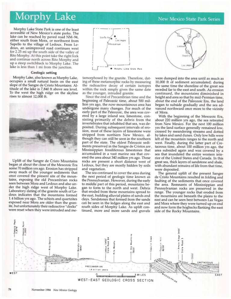
Morphy Lake State Park is one of the least accessibleof New Mexico's state parks. The lake can be reachedby paved road NM-g+, either south from Mora, or northwest from Sapelloto the village of Ledoux. From Ledoux, an unimproved road continues west t Morphy Loke Store Pork Geologic setting Morphy Lake, alsoknown as Murphy Lake, occupiesa small natural basin on the east slopeof the Sangrede Cristo Mountains. Altitude of the lake is7,840 ft above sealevel. To the west the high ridge on the skyline rises to almost 12,000ft. beginning of Paleozoictime, about 500 million yrs ago, the now-mountainousareahas undergonemany changes.For much of the early part of the Paleozoic,the areawas covered by a large inland sea; limestone, consisting primarily of the debris from the invertebratesthat inhabitedthat sea,was deposited.During subsequentintervalsof erosion, most of theselavers of limestonewere stripped from north'ern New Mexico, although they can still be seenin the southern part of the state. The oldest Paleozoicsedimentspreservedin the Sangrede Cristosare, i' t'sl Mississippian fossiliferous limestones that accumulatedin a vast marine sea that covered the areaabout 340million yrs ago. These Uplift of the Sangrede Cristo Mountains rocks are present a short distance west of beganat about the closeof the MesozoicEra Ledoux, but they are mostly hidden by soils some70million yrs ago.Erosionhas stripped and vegetation.away much of the younger sediments lhat The seacontinued to coverthe areaduring once covered the present site of the moun- the next period of geologic time known as tains, exposing the old Precambrianrocks the Pennsylvanian.However, during the early seenbetweenMora and Ledoux and alsoun- to middle part of this period, mountains beder the high ridge west of Morphy Lake. gan to form to the north and west. Debris Laboratory*datinfof the granite south of Le- that eroded from thesemountains spreadto doux indicates that the mountains formed the east,building alluvial plains of sandsand 1.4billion yrs ago. The schistsand quartzites clays.Sandstonesthat formed from the sands exposed near Mora are older than ihe gran- can be seenin the ledgesalong the eastand ite, but unfortunately their radioactive"clocks" south sides of Morphy Lake. As uplift conwere resetwhen they were intruded and me- tinued, more and more sands and gravels were dumped into the areauntil as much as 10,000ft of sediment accumulated;during the sametime the shorelineof the great sea recededfar to the eastand south. As erosion continued, the mountains diminished in height and areaso that by mid-Permian time, about the end of the PaleozoicEra, the land began to subside gradually and the sea advanced northward once more to the vicinity of Mora. With the beginning of the Mesozoic Era, about 220 million yrc ago, the sea retreated from New Metco. For the next 100 million yrs the land surfacegenerally remained low, crossedby meandering streamsand dotted by lakesand sanddunes. Only low hills were left of the mountain rangesto the north and west. Finally, during the latter part of Cretaceoustime, about 100 million yrs ago, the area subsided again and was covered by a sea that inundated the entire western interior of the United Statesand Canada.In this great sea,thick layersof sandstoneand shale, with abundantremainsof life from that time, were deposited. The general uplift of the present Sangre de Cristo Mountains resultedin folding and faulting of the sediments that once covered the area. Remnants of Mississippian and Pennsylvanian rocks are preserved in the range. The younger rocks that eroded from the mountains are beneath the plains to the eastand can be seenbestbetweenLas Vegas and Mora where they were turned up on end and now form the hogbacksflanking the east side of the Rocky Mountains. c 9-o : F ; @ -: 3 c I 3 oo q ; F6 0 >N II I a: G = E I I I I I 2 SMILES W E S T - E A S TG E O L O G I C C R O S SS E C T I O N 78 November 1984 New Mexico Geology : @ I I CRETACEOUS Looking west from Morphy Lake, the highest point is Cebolla Mountain at 11,870 ft. North of this peak several small, bowlshaped or amphitheatrelike reentrants occur in the ridge of Precambrianrocks.These featureswere formed by small mountain glaciers that developedon the east side of ihe photocollection NMBMMR byRobertW. Eveleth, NewMexico Bureau ol MinesandMineral Resources, Socorro, NM87801 Ho for the silver camps of the the Black Range!Suchwas the cry of the 19th century prospectorand miner in territorial New Mexico. By earlv 1.881the buccaneerof oick and pan could, if he so desired,purchasea ticket and enjoy the first classaccommodationsof San the Atchison, Topeka and SantaFe Railroad, Antonio disembarkat San Marcial or Engle, and procure passageon an adequate (if not luxuriously appointed)coachof the Pioneeror other History and surrounding area stage line. "Stages (left) promptly upon the When Mora was founded in 1835. New arrival of trains" for the Black Range silver camps including St. Charles, Philipsburg, Grafton, Robinson,Fairview,Roundy, Chlo- ' ride, and Hermosa(Fig.1) and went "ihrough by daylight" in 8 to lOiours if we can betie"ve the advertised schedule (Fig. 2). Oa if the Iucky traveler was bound for the famed silver small group of Irish founded the community mines of Lake Valley he could ride the rails of Cleveland just west of Mora, naming it right into town. The readerneed not feel dismayedif these after PresidentCleveland. Numerous scenicareas are near Morphy place names sound unfamiliar; Iike stars in LakeStatePark.Westof Mora, NM-3 croises the heavens,these camps blazed for a time the Sangrede Cristo Mountains to Taos.Much and then quickly faded with the silver crash of the route follows the Rio Pueblo. a beau- of 1893,never to shineagain.Sadly,they and tiful mountain stream with excellent trout the wav of life brieflv described above have fishing. The high ridge west of Morphy Lake vanishedin the misti of time, although Fairis within the PecosWildernessin which nu- view (now Winston), Chloride, and Lake merous trails lead past spectacularmountain Valley partially survive today. But memories vistas and alpine lakes and meadows. San- live on in imagessuch as the ones shown on FIGURE1-Location map of the Black Range, tiago, Pacheco,and EncantadoLakesoccupy the following page (Figs. 3-5), a small sam- southwestNew Mexico,and silvermining camps cirques.Difficult to reach, they offer excellent pling of the more than 1,000 views in the in that areabeforethe silvercrashof 1893. fishing plus the exhilaration of the alpine New Mexico Bureau of Mines and Mineral country above timberline. North of Mori via Resources'photo collection. The core of the collectionconsistsof pho- therefore, their use may be restricted. The tos made by various Bureau engineersand large majority, however, can be used freely geologistsfrom the 1940'sto the present,but if source credits and acknowledgmentsare more than a century of mining and industrial 8rven. activity is represented.Some of the images The collectionwas recentlyenhancedwith have been purchased from other collections, the acquisitionof a large group of U.S. Geosuchas the Rio GrandeHistoricalCollection/ logical Survey photos and, most -p= Facilities NMSU and the Silver City Museum, and, Morphy Lake has been enlarged by conskuction of a small dam. Water comes into the lake via an intake canal near the north side of the dam. The natural drainage area --O FOR t--E :BL-A-C== R-A-\TG:EI ! is quite small, and the lake basin has a max-.._lVfA.l+ imum storagecapacityof a little more than 400acreft (about 130million gal) and covers an area of about 25 acres.The State Game and Fish Department stocks the lake with rainbow trout. Tables, fireplaces, and toilet facilities are provided in the park, but drinking water is not available. PIOI'IEEH PIOI\IEE Stryq Stugq LINEI llrakes Corlnectlotrt RLACII RAIrtlGE, LINE! Rallroad wlth at SAN on tbc llne of tlreR.R. polnt !|ARlcIAL, belng the nearcat Slxty mlleesavedbytaklrrgthtsroute. to thc THROUGHIIY DAYLIGHT: TTMD.8 TO 10 HOURS. i<ARNS & MoCONKEY, Prop's. FIGURE 2-Advertisement for Karns & McConkey's Pioneer Stageline from San Marcial to the Black Range.-Taken trom Beckwith'sguide to the great mining and stock-lrowingdistrictof central New Mexico: Times Printingllorse, Leavenworth, Kansas, ca. 1881. Original is courtesy of Huntington Library, rare book no. 3M952, p. 77. New Mexico Geology November 1984 tantly, a superb collectiondonated by Frances Iahns in memory of Dr. Richard (Dick) H. iahns who passedaway in December1983. Dick is remembered fondly by those of us who are fortunate enough to have known him, but few people know that this gentleman, in addition to his more obvious scientific talents, was an accomplished photographeras well. Included in the Jahns ionation-are nearly 200 views of Ojo Caliente, Harding mine area, Hermosa, Iron Mountain, and Taylor Creek. Dick also was interested in historic Photos, and he collected about four dozen late 19th century views of Winston, Chloride, LakeValley,and Hermosa, which he custom printed himself. Most, if not all of these,appearto have been acquired from the Schmidt collection. In addition to the prints, the Bureau collection containsmore than 1.,000slidesin four major classifications: L) G series-general Buieau slides of mines, mills, geologic features, scenicviews, and miscellaneousevents; 2) H series-slide copies of historic photographs;3) M series-slides of unusualor muieuh-quality New Mexico mineral speciesin the Buieau museum, other national and internationalmuseum collections,and private collections;and 4) A series-slide copies of various rare maPs, documents, engraved FIGURE 3-Hermosa, New Mexico, probably before 1893 Few mining camps had a lovelier location; scenes(woodcuts), and artifacts associated Hermosa,which meansbeautiful in Spanish,is named appropriately.Hermosaproduced about $1,500,000 with New Mexico's geology, mineral techworth of silver and the town was sald to have "a population of 230 souls" in 7892,but they and all of nology, or mining historY. the structures shown in this photograph have vanished. Today this spot is an open, grassy meadow. The Bureauphoto collection has been used NMBMMR photo collection, no. 263, photographer unknown; donated by FrancesJahns in memory for educational displays at the State Fair, of Dr. RichardH. jahns. various scientific conventions, and semipermanent displays in the Bureau mineral museum and other display areas.All pho- Eveleth, Mining Engineer, NMBMMR, room 8126, Socorro, NM 87801, phone: 505/8355325. FIGURE 4-Lake Valley mining camp about 1890.This is one of New Mexico's more famous mining camps primarily becauie of the stupendous chlorargyrite (silver chloride) ores found in the legendary "Briilal-Chamber." It, and other bonanza orebodies, yielded more than five million ounces of silver by 1893. In this photograph Santa Fe locomotive No. 47 (American Type or 4-4-0) has been turned in preparation to pick up diminutive coach No. 505 for the southbound run to Nutt where it connected with the daily Silver City-Rincon hain. NMBMMR photo collection, no. 287; photographer probably Henry Schmidt; donated by FrancesJahns in memory of Dr. Richard H. Jahns. November 1,984 New Mexico Geology FIGURE S-Hoistman at the underground hoist station in the Fanney mine, Mogollon, New Mexico, about 1941.NMBMMR photo collection, no. 201;photographer unknown.
