GUIDE TO THE GEOLOGY OF THE EASTERN SIDE OF THE... VALLEY ALONG SOUTHBOUND I-25 FROM RIO BRAVO BOULEVARD TO
advertisement
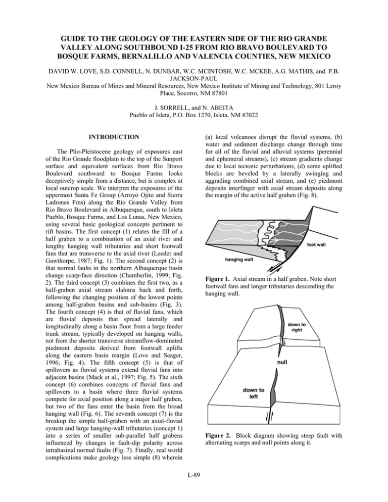
GUIDE TO THE GEOLOGY OF THE EASTERN SIDE OF THE RIO GRANDE VALLEY ALONG SOUTHBOUND I-25 FROM RIO BRAVO BOULEVARD TO BOSQUE FARMS, BERNALILLO AND VALENCIA COUNTIES, NEW MEXICO DAVID W. LOVE, S.D. CONNELL, N. DUNBAR, W.C. MCINTOSH, W.C. MCKEE, A.G. MATHIS, and P.B. JACKSON-PAUL New Mexico Bureau of Mines and Mineral Resources, New Mexico Institute of Mining and Technology, 801 Leroy Place, Socorro, NM 87801 J. SORRELL, and N. ABEITA Pueblo of Isleta, P.O. Box 1270, Isleta, NM 87022 (a) local volcanoes disrupt the fluvial systems, (b) water and sediment discharge change through time for all of the fluvial and alluvial systems (perennial and ephemeral streams), (c) stream gradients change due to local tectonic perturbations, (d) some uplifted blocks are beveled by a laterally swinging and aggrading combined axial stream, and (e) piedmont deposits interfinger with axial stream deposits along the margin of the active half graben (Fig. 8). INTRODUCTION The Plio-Pleistocene geology of exposures east of the Rio Grande floodplain to the top of the Sunport surface and equivalent surfaces from Rio Bravo Boulevard southward to Bosque Farms looks deceptively simple from a distance, but is complex at local outcrop scale. We interpret the exposures of the uppermost Santa Fe Group (Arroyo Ojito and Sierra Ladrones Fms) along the Rio Grande Valley from Rio Bravo Boulevard in Albuquerque, south to Isleta Pueblo, Bosque Farms, and Los Lunas, New Mexico, using several basic geological concepts pertinent to rift basins. The first concept (1) relates the fill of a half graben to a combination of an axial river and lengthy hanging wall tributaries and short footwall fans that are transverse to the axial river (Leeder and Gawthorpe, 1987; Fig. 1). The second concept (2) is that normal faults in the northern Albuquerque basin change scarp-face direction (Chamberlin, 1999; Fig. 2). The third concept (3) combines the first two, as a half-graben axial stream slaloms back and forth, following the changing position of the lowest points among half-graben basins and sub-basins (Fig. 3). The fourth concept (4) is that of fluvial fans, which are fluvial deposits that spread laterally and longitudinally along a basin floor from a large feeder trunk stream, typically developed on hanging walls, not from the shorter transverse streamflow-dominated piedmont deposits derived from footwall uplifts along the eastern basin margin (Love and Seager, 1996; Fig. 4). The fifth concept (5) is that of spillovers as fluvial systems extend fluvial fans into adjacent basins (Mack et al., 1997; Fig. 5). The sixth concept (6) combines concepts of fluvial fans and spillovers to a basin where three fluvial systems compete for axial position along a major half graben, but two of the fans enter the basin from the broad hanging wall (Fig. 6). The seventh concept (7) is the breakup the simple half-graben with an axial-fluvial system and large hanging-wall tributaries (concept 1) into a series of smaller sub-parallel half grabens influenced by changes in fault-dip polarity across intrabasinal normal faults (Fig. 7). Finally, real world complications make geology less simple (8) wherein Figure 1. Axial stream in a half graben. Note short footwall fans and longer tributaries descending the hanging wall. Figure 2. Block diagram showing steep fault with alternating scarps and null points along it. L-89 NMBMMR OFR 454B emplacement of the UBT. The breakout flood likely swept through the Jemez River canyon, picked up boulders of Tertiary basalts and Precambrian crystalline rocks, and spread out across the Sunport surface. The Rio Grande reworked these flood deposits shortly after this flood and prior to entrenchment of the present valley. A waterreworked fine-grained ash from within the upper part of the section yielded sanidine crystals with peaks in the age spectra from 1.05 to 1.7 Ma; however, the younger age is associated with fairly low concentrations of potassium, which suggests that part of this ash was altered. Thus, this 1.05 Ma date is too young. An ash bed, recognized below the Sunport surface along the southern margin of Tijeras Arroyo, yielded a 40Ar/39Ar date of 1.26±0.02 Ma, which is consistent with an upper Bandelier Tuff age. A fluvial terrace deposit of the ancestral Rio Grande west of the Rio Grande is lower than the Sunport, suggesting that it is inset against the Sunport surface. This terrace deposit contains a fluvially recycled ash that has been chemically correlated to the ca. 0.600.66 Ma Lava Creek B ash from the Yellowstone hotspot in Wyoming. These two tephra constrain the age of the Sunport surface to between 1.2-0.6 Ma. Paleomagnetic studies of fine-grained deposits near the local top of the section, between Hell Canyon Wash and Tijeras Arroyo, are pending. GEOLOGY AND GEOMORPHOLOGY OF THE ISLETA AREA If these concepts are to be applied to the geology of the Isleta area, the scale of the concepts must match local conditions. Applying concept 1 (the axial stream in a half graben with broad hanging wall) to this area, the major half-graben fault in PlioPleistocene time is the Hubbell Spring fault zone, 13 km east of the west edge of the Sunport surface. The axial-fluvial systems tract of the early Pleistocene ancestral Rio Grande is also about 13 km wide beneath the Sunport and Llano de Manzano surfaces. The hanging wall with tributaries extended ~ 26-32 km east from the valley of the Rio Puerco to the axial ancestral Rio Grande near the latitude of southern Albuquerque. These fluvial fans had headwaters beyond the hanging wall and crossed the basin diagonally from the north and northwest extending 48-161 km north-south. They deposited sediments over hundreds of square km up-gradient from the axial Rio Grande. High sediment delivery to the basin from the major tributaries probably overwhelmed small tectonic disruptions on the hanging wall. Figure 3. Block diagram illustrating axial stream that slaloms between half grabens along alternatingscarp fault blocks. Working downsection from the Sunport surface, at the top of the exposures beneath eolian sheet sands and a strong stage III to local stage IV calcic soil are sand and gravel of the ancestral Rio Grande. This >10-m thick gravelly sand is a mixture of resistant, well-rounded clasts of extrabasinal origin that include boulders (up to 4 m in diameter) of upper Bandelier Tuff (UBT, 1.22 Ma). Also included are locally preserved Tschirege Ash (1.22 Ma; see below), pebbles of Tewa-Group pumice and obsidian from the Jemez Mountains (beginning with the 1.8-Ma San Diego Canyon Ignimbrite; cf. Self et al., 1996). The boulders were probably deposited as a result of a breakout flood from a breached lake in the Valles caldera that formed soon after caldera collapse and Figure 4. Fluvial fans of the Rio Mimbres system (from Love and Seager, 1996). Note that the Mimbres fluvial system is already out in a basin before it spreads into fan shapes. L-90 NMBMMR OFR 454B well, 6.5 km southeast of the Rio Bravo interchange, at least 500 m of fluvial sediments were penetrated. Valley-margin exposures between Tijeras Canyon and Hell Canyon are cut by three major, and numerous minor faults in a north-northwest-trending zone called the Palace-Pipeline fault zone. Two of the major faults are normal, down to the west. The third is down to the east. There are hints of strike-slip motion as well, but no definitive piercing points to demonstrate horizontal movement. Minor faults are subparallel to this zone, but tend to bend to the east or west. Although the topographic relief of the present valley is about 130 m, the total exposed stratigraphic section is more than 135 m thick because of faulting and local stratal tilts. Beds dip as much as 7ºSE; apparent dips along the outcrop belt are roughly 1º to the south. The southeastward tilt has preserved the middle and upper parts of the stratigraphic section above that seen on the highest block and below the youngest fluvial deposits of the Sunport surface (Fig. 10). The highest exposed structural block is stripped of at least 73 m of section seen on other blocks. Critical stratigraphic markers for the Plio-Pleistocene section include <5 cm-thick basaltic tephra geochemically correlated to Isleta volcano (2.7-2.8 Ma), Hawaiite tephra (unknown age), fluvially recycled Pliocene pumice and Bandelier Tuff, and thick (~24 m) reddish-brown clay, silty clay, and fine sand. Figure 5. Spillover fluvial systems in different basinal situations (from Mack et al., 1997). Mimbres type (A), where the fluvial system enters and flows through the basin nearly parallel to the footwall scarp and axial valley. Columbus type (B), in which the fluvial system flows down the hanging wall dip slope of the spillover basin and builds a fluvial fan perpendicular to the footwall scarp. Tularosa type (C), in which the fluvial system moves across the footwall scarp into the spillover basin and builds a fluvial fan on the hanging wall dip slope perpendicular to the basin axis. The axial Rio Grande deposits associated with the Sunport surface and Llano de Manzano are cut by numerous normal faults with separation of up to 15 m (Fig. 9). This faulted surface is partially buried by a piedmont alluvial apron prograding west from the Manzanita and Manzano Mountains. Beneath the upper 10 m of sediment, the valleymargin geology is complicated. Locally, ancestral Rio Grande fluvial deposits, containing Tewa-Group pumice and obsidian, extend 30 m below the Sunport surface where they rest upon Pliocene deposits of the Arroyo Ojito Formation. Biostratigraphic data indicate the presence of a disconformity between the Arroyo Ojito Fm and pumice-bearing fluvial deposits of the Sierra Ladrones Formation. To the south, near Isleta Pueblo, this disconformity is more pronounced and occurs within 10 m of the Sunport surface, where it is an angular unconformity. Ancestral Rio Grande deposits tend to thicken to the east, where they are exposed in the walls of both Tijeras Canyon and Hell Canyon. At a monitoring well drilled on Mesa del Sol Figure 6. Schematic half-graben basin with axial fluvial system and two fluvial fans (ff1 and ff2) descending the hanging wall. At the southern end of the exposures (Fig. 10), about 20 m of section is exposed between the top of the axial gravel and an exposure of lower(?) Bandelier ash that has been dated at about 1.55 Ma. An 40Ar/39Ar date on this ash sampled north of Hell L-91 NMBMMR OFR 454B Canyon was interpreted to include crystals of the 1.05 Ma Valles dome rhyolite (Love et al., 2001), but these crystals have been recently reinterpreted to be fluvially reworked Bandelier ash (N. Dunbar and W. McIntosh, personal commun., 2001). Beneath this ash north of Hell Canyon is about 30 m of crossbedded, pumice-bearing, loose pebbly sand of the ancestral Rio Grande. Beneath them are pale, cemented, fine-grained deposits that indicate a high local water table (spring-related or krenegenic deposits). Below these deposits are 24 m of finegrained reddish-brown beds and 49 m of crossbedded, planar-bedded sand, and cross-bedded pebbly-to-cobbly sand. The sandy units locally include at least 4 different pumice-bearing beds. Below is basaltic tephra correlated to the eruptions of the Isleta tuff ring, base surge, lava flows and other cinder eruptions. These tephra are found on at least four different structural blocks at various elevations. Maximum offset across at least two faults is about 100 m. south, the units include volcanic clasts from both the western side of the Jemez Mountains (paleo-Jemez River to the north) and clasts from the Rio Puerco (coming into the Albuquerque basin from the northwest). Both types of deposits were spread across the northern Albuquerque basin as low-gradient fluvial fans that interfingered with each other. Reworked, water-rounded pumice from Jemez eruptions spread laterally at least 24 km east-west, and at least 113 km north-south. These fluvial fans descended southeastward to join the axial Rio Grande, which was the axial stream along the Hubbell Spring fault zone. The presence of relatively monolithologic pumice-bearing units 113 km south of their source in the Jemez Mountains suggests that these streams may have followed local alternating half-graben sub-basins (west of here, closer to Wind Mesa). The reddish-brown marker unit with springrelated units at the top, followed by deposition of ancestral Rio Grande along the Isleta valley-border transect, may signal a rearrangement of the structure of the hanging-wall and a subsequent adjustment of the northern and western fluvial fans. Figure 7. Block diagram showing the breakup of the half-graben hanging wall into several segments and the underlying stratigraphy resulting from fluvial fans and axial system of Figure 6. Continuing downward in the section, beneath the Isleta tephra on the central uplifted block are another 21 m of cross-bedded pebbly sand, sand, and siltyclay planar beds. Locally, at least two more pumicebearing beds crop out below the Isleta tephra. North of Isleta, beneath Mesa del Sol are Pliocene sections exposed on uplifted fault blocks. One measured section includes 17 m of concretionary sandstone, silt, and clay with a 3-cm thick Hawaiite ash beneath coarser crossbedded loose sand. Another 35-m section has a pumice bed at its base that correlates geochemically to a pumice bed beneath Los Lunas Volcano to the southwest and Rio Rancho to the northwest. This pumice bed is in the same part of the section at Los Lunas volcano that contains an 40 Ar/39Ar-dated 3.12 Ma pumice (Maldonado et al., 1999). The Pliocene crossbedded sandstones, pebbly sandstones, pumice and basaltic tephra-bearing sandstones beneath the thick reddish-brown finegrained marker are part of a thick, laterally extensive package of transverse fluvial deposits. This package, deposited by major western-margin rivers and streams, is called the Arroyo Ojito Formation (Connell et al., 1999). From Rio Bravo Boulevard Figure 8. Block diagram showing complications of lateral erosion of axial stream across fault blocks, buried volcano, and advancement of piedmont across part of floodplain. Exposures in Tijeras and Hell Canyons as well as along the Rio Grande Valley near Isleta show that more than 30 m of axial Rio Grande sand and gravel aggraded before the stream shifted westward. It beveled and buried at least two uplifted fault blocks, received breakout flood debris from the Jemez River, and finally began to entrench the present valley west of its former course (Fig. 10). Across the valley southwest of this stop are Black Mesa and Isleta volcano, two Pliocene basaltic eruptive units with 40Ar/39Ar dates ranging from 2.7 to 2.8 Ma (Maldonado et al., 1999). In erosional contact with, above, and inset below the basalts, are several levels of inset terrace deposits. The highest terrace is 79 m above the Rio Grande. In the gravel pit north of the Black Mesa basalt flow is an exposure of Lava Creek B ash, about 46 m above the river. L-92 NMBMMR OFR 454B Basin, Rio Grande rift, New Mexico: Geological Society of America, Abstracts with Programs, v. 31, no. 7, p. A-113. Connell, S.D., Koning, D.J., and Cather, S.M., 1999, Revisions to the stratigraphic nomenclature of the Santa Fe Group, northwestern Albuquerque Basin, New Mexico: New Mexico Geological Society, Guidebook 50, p. 337-353. Leeder, M. R., and Gawthorpe, R. L., 1987, Sedimentary models for extensional tiltblock/half-graben basins, in Coward, M. P., Dewey, J. F., and Hancock, P. L, eds, Continental Extensional Tectonics: Geological Society of London, Special Publication 28, p. 139-152. Love, D.W., Connell, S.D., Chamberlin, R.M., Cather, S.M., McIntosh, W.C., Dunbar, N., Smith, G.A., Lucas, S.G., 2001, Constraints on the age of extensive fluvial facies of the upper Santa Fe Group, Albuquerque and Socorro basins, central New Mexico: Geological Society of America, Abstracts with Programs, v. 33, n. 5, p. A48. Love, D. W., and Seager, W. R., 1996, Fluvial fans and related basin deposits of the Mimbres drainage: New Mexico Geology, v. 18, p. 81-92. Love, D.W., Dunbar, N., McIntosh, W.C., McKee, C., Connell, S.D., Jackson-Paul, P.B., and Sorrell, J., 2001, Late Miocene to Early Pleistocene geologic history of Isleta and Hubbell Spring quadrangles based on ages and geochemical correlation of local and Regional volcanic rocks [abs]: New Mexico Geology, v. 23, p. 55. Mack, G. H., Love, D. W., and Seager, W. R., 1997, Spillover models for axial rivers in regions of continental extension: the Rio Mimbres and Rio Grande in the southern Rio Grande rift, USA: Sedimentology, v. 44, p. 637-652. Figure 9. Digital elevation model of Sunport surface between Tijeras Canyon and Hell Canyon showing faulted blocks and encroachment of piedmont from east. Figure 10. Schematic north-south sketch of about 18 km of exposures of Santa Fe-Group sediments from Rio Bravo Boulevard (I-25, exit 220) to bluffs east of Bosque Farms, New Mexico. ACKNOWLEDGEMENTS This study was funded in part by the New Mexico Statemap Program of the National Cooperative Geologic Mapping Act (P.W. Bauer, Program Manager) and the New Mexico Bureau of Mines and Mineral Resources (P.A. Scholle, Director). We thank the Pueblo of Isleta for graciously allowing access onto tribal lands during this study. We also thank Florian Maldonado (U.S. Geological Survey) for his considerable help and advice on the geology and stratigraphy of western part of Isleta Pueblo. Maldonado, F, Connell, S. D., Love, D. W., Grauch, V. J. S., Slate, J. L., McIntosh, W. C., Jackson, P. B., and Byers, F. M. Jr., 1999, Neogene geology of the Isleta Reservation and vicinity, Albuquerque basin, New Mexico: New Mexico Geological Society Guidebook 50, p. 175-188. Self, S., Heiken, G., Sykes, M. L., Wohlets, K., Fisher, R. V., and Dethier, D. P., 1996, Field excursions to the Jemez Mountains, New Mexico: New Mexico Bureau of Mines and Mineral Resources, Bulletin 134, 72 p. REFERENCES Chamberlin R. M., 1999, Partitioning of dextral slip in an incipient transverse shear zone of Neogene Age, northwestern Albuquerque L-93

