File
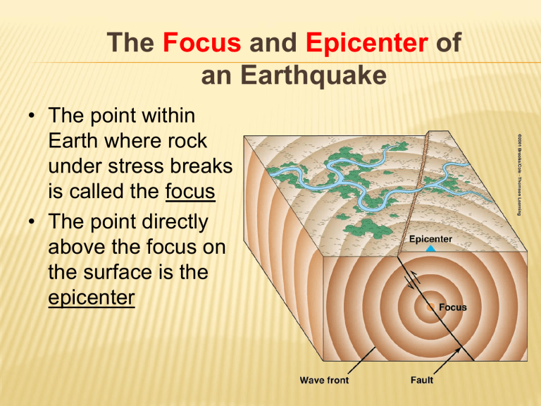
The Focus and Epicenter of an Earthquake
• The point within
Earth where rock under stress breaks is called the focus
• The point directly above the focus on the surface is the epicenter
WHAT ARE SEISMIC WAVES?
Vibrations that travel through
Earth carrying the energy released during an earthquake
Energy starts at the focus and moves outward
Two types:
Body waves
P and S
Surface waves
P Waves
S Waves
BODY WAVES: P AND S WAVES
Undisturbed Material
Body waves
P or primary/pressure waves
fastest waves
travel through solids, liquids, or gases
Waves compress and expand like an accordian
S or secondary/shear waves
slower than P waves
travel through solids only
Move up and down as well as side to side
R waves
SURFACE WAVES:
R waves L waves
L waves
Surface Waves
Travel just below or along the ground’s surface
Slower than body waves
Surface waves are the most damaging and are especially damaging to buildings.
Seismographs record earthquake events
HOW IS AN EARTHQUAKE’S EPICENTER
P waves arrive first, then S waves, then surface waves
Average speeds for all these waves is known
After an earthquake, the difference in arrival times at a seismograph station can be used to calculate the distance from the seismograph to the epicenter.
WHERE DO EARTHQUAKES OCCUR AND HOW
OFTEN?
~80% of all earthquakes occur in the circum-Pacific belt
~15% occur in the Mediterranean-Asiatic belt
~remaining 5% occur in the interiors of plates and on spreading ridge centers
more than 150,000 quakes strong enough to be felt are recorded each year
HOW DO YOU LOCATE AN EPICENTER?
The Focus and Epicenter of an Earthquake
•The point within Earth where rock under stress breaks is called the
Focus
•The point directly above the focus on the surface is the Epicenter.
Surface epicenter
A focus
B
Which seismic
Station will
Receive the
Wave first?
A or B
HOW DO YOU LOCATE AN EPICENTER?
You must have three different seismographs at three different
Locations - then you can pinpoint the different times each picked up the earthquake wave. A scientist will do this in a lab.
A
Surface epicenter
B focus
HOW IS AN EARTHQUAKE’S EPICENTER
LOCATED?
Three seismograph stations are needed to locate the epicenter of an earthquake
A circle where the radius equals the distance to the epicenter is drawn
The intersection of the circles locates the epicenter
HOW IS AN EARTHQUAKE’S EPICENTER
LOCATED?
Time-distance graph shows the average travel times for Pand S-waves. The farther away a seismograph is from the focus of an earthquake, the longer the interval between the arrivals of the Pand S- waves
HOW ARE THE SIZE AND STRENGTH OF AN
EARTHQUAKE MEASURED?
Magnitude: the measurement of earthquake strength based on seismic waves and movement along faults
THREE WAYS OF MEASURING
EARTHQUAKES:
Mercalli Scale measures the intensity of an earthquake
Richter Scale is a rating of the size of seismic waves
Moment Magnitude Scale estimates the total energy released by an earthquake
MERCALLI
SCALE
RICHTER SCALE
THE ECONOMICS AND SOCIETAL IMPACTS OF EQS
• Building collapse
•
Fire
• Tsunami
•
Ground failure
Damage in Oakland , CA, 1989
WHAT ARE THE DESTRUCTIVE EFFECTS OF
EARTHQUAKES?
Ground Shaking
The earthquake’s amplitude, how long it lasts, and damage increases in poorly consolidated rocks
EARTHQUAKE HAZARDS
Local soil conditions: loose soil shakes more violently than the surrounding rock (house built on solid rock will shake less than a house build on sandy soil)
Liquefaction: earthquakes violent shaking suddenly turns loose soil into liquid mud
Aftershocks: buildings weakened by an earthquake may collapse during aftershocks
Tsunamis: earthquakes on the ocean floor cause large waves that can grow to the height of a six story building
CAN EARTHQUAKES BE PREDICTED?
Forecasting when and where earthquakes will occur and their strength is difficult.
One way seismologist forecast earthquakes in a place is to observe their past strength and frequency.
EARTHQUAKE HAZARD
Earthquake hazard is a measurement of how likely an area is to have damaging earthquakes in the future. An area’s earthquake-hazard level is determined by past and present seismic activity.
FORECASTING EARTHQUAKES
A seismic gap is an area along a fault where relatively few earthquakes have occurred recently but where strong earthquakes are known to have occurred in the past. Ex:
California
The gap hypothesis states that sections of active faults that have had relatively few earthquakes are likely to be the sites of strong earthquakes in the future.


