on the Bosphorus.
advertisement
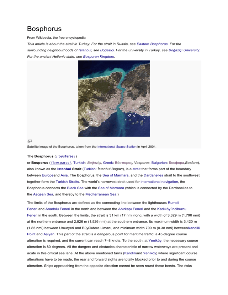
Bosphorus From Wikipedia, the free encyclopedia This article is about the strait in Turkey. For the strait in Russia, see Eastern Bosphorus. For the surrounding neighbourhoods of Istanbul, see Boğaziçi. For the university in Turkey, see Boğaziçi University. For the ancient Hellenic state, see Bosporan Kingdom. Satellite image of the Bosphorus, taken from the International Space Station in April 2004. The Bosphorus (/ˈbɒsfərəs/) or Bosporus (/ˈbɒspərəs/, Turkish: Boğaziçi, Greek: Βόσπορος, Vosporos, Bulgarian: Босфора,Bosfora), also known as the Istanbul Strait (Turkish: İstanbul Boğazı), is a strait that forms part of the boundary between Europeand Asia. The Bosphorus, the Sea of Marmara, and the Dardanelles strait to the southwest together form the Turkish Straits. The world's narrowest strait used for international navigation, the Bosphorus connects the Black Sea with the Sea of Marmara (which is connected by the Dardanelles to the Aegean Sea, and thereby to the Mediterranean Sea.) The limits of the Bosphorus are defined as the connecting line between the lighthouses Rumeli Feneri and Anadolu Feneri in the north and between the Ahırkapı Feneri and the Kadıköy İnciburnu Feneri in the south. Between the limits, the strait is 31 km (17 nmi) long, with a width of 3,329 m (1.798 nmi) at the northern entrance and 2,826 m (1.526 nmi) at the southern entrance. Its maximum width is 3,420 m (1.85 nmi) between Umuryeri and Büyükdere Limanı, and minimum width 700 m (0.38 nmi) betweenKandilli Point and Aşiyan. This part of the strait is a dangerous point for maritime traffic: a 45-degree course alteration is required, and the current can reach 7–8 knots. To the south, at Yeniköy, the necessary course alteration is 80 degrees. All the dangers and obstacles characteristic of narrow waterways are present and acute in this critical sea lane. At the above mentioned turns (Kandilliand Yeniköy) where significant course alterations have to be made, the rear and forward sights are totally blocked prior to and during the course alteration. Ships approaching from the opposite direction cannot be seen round these bends. The risks posed by geography are increased dramatically by the heavy ferry traffic across the strait, linking the European and Asian sides of the city.[1] The depth of Bosphorus varies from 36 to 124 m (118 to 407 ft) in midstream with an average of 65 m (213 ft). The deepest location is between Kandilli and Bebek with 110 m (360 ft). The most shallow locations are off Kadıköy İnciburnu on the northward route with 18 m (59 ft) and off Aşiyan Point on the southward route with 13 m (43 ft).[1] The shores of the strait are heavily populated, straddled as it is by the city of Istanbul (with a metropolitan area population in excess of 12 million inhabitants) which extends inland from both coasts. The name comes from Greek Bosporos (Βόσπορος),[2] which the ancient Greeks analysed as bous βοῦς 'ox' + poros πόρος 'means of passing a river, ford, ferry', thus meaning 'ox-ford', which is a reference to Io (mythology) from Greek mythology who was transformed into a cow and condemned to wander the earth until she crossed the Bosphorus where she met Prometheus. Although it has been known for a while that the Black Sea and the Sea of Marmara flow into each other in an example of a density flow, findings of a study by the University of Leeds in August 2010 reveal that there is in fact an underwater channel of high-density water flowing across the floor of the Bosphorus (caused by the difference in density of the two seas), which would be the sixth largest river on Earth if it were to be on land.[3] Formation[edit] Main article: Black Sea deluge theory A map depicting the location of the Bosphorus (red) relative to the Dardanelles(yellow) and the Sea of Marmara, which together form the Turkish Straits. The exact cause for the formation of the Bosphorus remains the subject of debate among geologists. Thousands of years ago, the Black Sea became disconnected from the Aegean Sea. The Black Sea deluge theory (published in 1997 by William Ryan and Walter Pitmanfrom Columbia University) contends that the Bosphorus was formed about 5600 BC when the rising waters of the Mediterranean/Sea of Marmara breached through to the Black Sea, which at the time (according to the theory) was a low-lying body of fresh water. It is also said in myth that floating rocks known as the Symplegades or Clashing Rocks once crushed any ship that attempted passage of the Bosphorus until the hero Jason obtained passage, whereupon the rocks became fixed, and Greek access to the Black Sea was opened. Ancient Greece, Persia, Rome, the Byzantines and the Ottoman Empire[edit] The Bosphorus with the Castles of Europe and Asia. 19th-century engraving byThomas Allom. The castles are Rumelihisarıand Anadoluhisarı, respectively. As part of the only passage between the Black Sea and the Mediterranean, the Bosporus has always been of great commercial and strategic importance. The Greek city-state of Athens in the 5th century BC, which was dependent on grain imports from Scythia, maintained critical alliances with cities which controlled the straits, such as the Megarian colony Byzantium. Persian King Darius I the Great, in an attempt to subdue the Scythian horsemen who roamed across the north of the Black Sea, crossed through the Bosphorus, then marched towards the Danube River. His army crossed the Bosphorus over an enormous bridge made by connecting Achaemenid boats.[4] This bridge essentially connected the farthest geographic tip of Asia to Europe, encompassing at least some 1000 meters of open water if not more.[5] Years later, a similar boat bridge would be constructed by Xerxes I on the Dardanelles (Hellespont) strait, during his invasion of Greece. Byzantines called the Bosphorus "Stenon" and most important toponyms of it Bosphorios Akra, Argyropolis, St. Mamas, St. Phokas, Hestiai or Michaelion, Phoneus, Anaplous or Sosthenion in European side and Hieron tower, Eirenaion, Anthemiou, Sophianai, Bithynian Chryspolis in Asian side in this era [6] The strategic significance of the strait was one of the factors in the decision of the Roman Emperor Constantine the Great to found there in AD 330 his new capital, Constantinople, which came to be known as the capital of the Eastern Roman Empire. On 29 May 1453 it was conquered by the emerging Ottoman Empire. In fact, as the Ottoman Turks closed in on Constantinople, they constructed a fortification on each side of the strait, Anadoluhisarı (1393) and Rumelihisarı (1451). Strategic importance[edit] A view of the Bosphorus strait, with the Fatih Sultan Mehmet Bridge seen in the background. The strategic importance of the Bosphorus remains high. It is a major sea access route for Russia. Control over it has been an objective of a number of hostilities in modern history, notably the Russo– Turkish War, 1877–1878, as well as of the attack of theAllied Powers on the Dardanelles during the 1915 Battle of Gallipoli in the course of World War I. At its peak in the 16th through the 18th centuries, the Ottoman Empire had wrested control of the entire Black Sea area, which was for the time an "Ottoman lake", on which Russian warships were prohibited.[7] Subsequently, several international treaties have governed vessels using the waters. Under the Treaty of Hünkar Iskelesi of 1833, the Bosporus and Dardanelles straits were to be closed on Russian demand to naval vessels of other powers.[8] Following World War I, the 1920 Treaty of Sèvres demilitarized the strait and made it an international territory under the control of the League of Nations. This was amended under the 1923 Treaty of Lausanne, which restored the straits to Turkish territory—but allowed all foreign warships and commercial shipping to traverse the straits freely. Turkey eventually rejected the terms of that treaty, and subsequently Turkey remilitarized the straits area. The reversion to this old regime was formalized under the Montreux Convention Regarding the Regime of the Turkish Straits of July 1936. That convention, which is still in practical force as of 2011, treats the straits as an international shipping lane, but Turkey retains the right to restrict the naval traffic of non-Black Sea nations (such as Greece, a traditional enemy, or Algeria). During World War II, through February 1945, when Turkey was neutral for most of the length of the conflict, the Dardanelles were closed to the ships of the belligerent nations. In the conferences during World War II, Soviet leader Joseph Stalin openly requested the concession of Soviet military bases on the Straits, even though Turkey was not involved in the war. This incident, coupled with Stalin's demands for the restitution of the Turkish provinces of Kars, Artvin and Ardahan to the Soviet Union (which were lost by Turkey with the Russo–Turkish War of 1877–1878, but were regained with the Treaty of Kars in 1921) was one of the main reasons why Turkey decided to give up its general principle of neutrality in foreign affairs. Turkey did declare war against Germany in February 1945, but did not engage in offensive actions.[9][10][11][12] In more recent years, the Turkish Straits have become particularly important for the oil industry. Russian oil, from ports such as Novorossyisk, is exported by tankers to western Europe and the U.S. via the Bosphorus and the Dardanelles straits. Fatih Sultan Mehmet Bridge (1988) and the Bosphorus strait Crossings[edit] Fatih Sultan Mehmet Bridge (1988) as seen from the Rumelian Castle (1452) Bosphorus Bridge (1973) The waters of the strait are traversed by numerous ferries. Two suspension bridges cross the Bosphorus. The first of these, the Bosphorus Bridge, is 1,074 m (3,524 ft) long and was completed in 1973. The second, named Fatih Sultan Mehmet (Bosphorus II) Bridge, is 1,090 m (3,576 ft) long, and was completed in 1988 about 5 km (3 mi) north of the first bridge. The Bosphorus Bridge forms part of the O1 Motorway, while the Fatih Sultan Mehmet Bridge forms part of the Trans-European Motorway. Plans for a third suspension bridge, which will allow transit traffic to by-pass the city traffic, have been approved by the Ministry of Transportation in 2012. The construction of the project was awarded to the İçtaş-Astaldi consortium on May 29, 2012.[13] The construction began on May 29, 2013, and the bridge's opening is set for May 29, 2015. It is named Yavuz Sultan Selim Bridge.[14] The bridge will be built near the northern end of the Bosphorus, between the villages of Garipçe on the European side and Poyrazköy on the Asian side.[15] It will be part of the "Northern Marmara Motorway", which will be further integrated with the existing Black Sea Coastal Highway. Another crossing, the Marmaray tunnel, is a 13.7 km (8.5 mi) long undersea railway tunnel currently under construction and is expected to be completed in 2015. Approximately 1,400 m (4,593 ft) of the tunnel will run under the strait, at a depth of about 55 m (180 ft). An undersea water supply tunnel with a length of 5,551 m (18,212 ft),[16] named the Bosphorus Water Tunnel, was constructed in 2012 to transfer water from the Melen Creek inDüzce Province (to the east of the Bosphorus strait, in northwestern Anatolia) to the European side of Istanbul, from a distance of 185 km (115 mi).[16][17] The phrase "swim the Bosphorus" or "crossing the Bosphorus" is used to indicate religious conversion to the Eastern Orthodox Church. Submarine channel[edit] A cruise ship (left) and Seabus (right) navigating through the Bosphorus, with the Dolmabahçe Palace seen at the right end of the frame. In 2010, a team of scientists led by the University of Leeds used a robotic "yellow submarine" to observe detailed flows within an "undersea river" for the first time. Submarine channels are similar to land rivers, but they are formed by density currents—underwater flow mixtures of sand, mud and water that are denser than sea water and so sink and flow along the bottom. These channels are the main transport pathway for sediments to the deep sea where they form sedimentary deposits. These deposits ultimately hold not only untapped reserves of gas and oil, they also house important secrets—from clues on past climate change to the ways in which mountains were formed. The team, led by Dr. Dan Parsons and Dr. Jeff Peakall from the University of Leeds, has been able to study the detailed flow within these channels. According to Dr. Parsons: "The channel complex and the density flow provide the ideal natural laboratory for investigating and detailing the structure of the flow field through the channel. Our initial findings show that the flow in these channels is quite different to the flow in river channels on land. Specifically, as flow moves around a bend it spirals in the opposite direction in the deep sea compared to the spiral to that found in river channels on land. This is important in understanding the sedimentology and layers of sediment deposited by these systems."[18] Skyline of Levent as seen from the Khedive Palace gardens on the Asian coast of the Bosphorus. Istanbul Sapphire is the first skyscraper at right. It is thought by some that the channels in the Black Sea were formed around 6,000 years ago when sea levels were approaching their current point. The Mediterranean swelled and breached through into the Black Sea—once an isolated freshwater lake—via the Bosphorus Strait. As the waters surged, they carried a dense, salty fluid which formed a network of sea-floor channels that are almost constantly active, even today. Some people even believe that this was the biblical event of Noah's flood, but despite their historical significance, the first spectacular images of these submarine channels were obtained in 1999 (Di Iorio, et al., 1999[19]) in the frame of a NATO SACLANT Undersea Research project using jointly the NATO RVAlliance, and the Turkish Navy survey ship Çubuklu. In 2002, a new survey was carried out on board the Ifremer RV Le Suroit for BlaSON project (Lericolais, et al., 2003[20]) completed the multibeam mapping of this underwater channel fan-delta. A complete map was published in 2009 (Flood, et al., 2009[21]) using these previous results with high quality mapping obtained in 2006 (by researchers at Memorial University, Newfoundland, Canada who are project partners in this study.) The team will use the data obtained to create innovative computer simulations that can be used to model how sediment flows through these channels. The models the team will produce will have broad applications, including inputting into the design of seafloor engineering by oil and gas companies. The project was led by Dr. Jeff Peakall and Dr. Daniel Parsons at the University of Leeds, in collaboration with the University of Southampton, Memorial University (Newfoundland, Canada), and the Institute of Marine Sciences (Izmir, Turkey). The survey was run and coordinated from the Institute of Marine Sciences research ship, the R/V Koca Piri Reis. The researchers estimate that the river—known as a submarine channel—would be the sixth largest river in the world if it were on land based on the amount of water flowing through it.[3] Panoramic view of a portion of the Bosphorus, as seen from the Ulus neighbourhood on the European side, with the Fatih Sultan Mehmet Bridge (1988) at left and the Bosphorus Bridge (1973) at right. Sightseeing See also: Yalı, Ferries in Istanbul, and İDO Ottoman era waterfront houses (yalı) on the Bosphorus. The Bosphorus is particularly famous for the 620 historic waterfront houses (yalı) built during the Ottoman period, which stretch along the strait's European and Asian shorelines. Ottoman palaces such as the Topkapı Palace, Dolmabahçe Palace, Yıldız Palace, Çırağan Palace, Feriye Palaces, Beylerbeyi Palace, Küçüksu Palace, Ihlamur Palace, Hatice Sultan Palace, Adile Sultan Palace and Khedive Palace also adorn the shores and hills of the strait; together with other landmark monuments and buildings such as the Hagia Sophia,Hagia Irene, Sultan Ahmed Mosque, Yeni Mosque, Kılıç Ali Pasha Mosque, Nusretiye Mosque, Dolmabahçe Mosque, Ortaköy Mosque,Üsküdar Mihrimah Sultan Mosque, Yeni Valide Mosque, Maiden's Tower, Galata Tower, Rumelian Castle, Anatolian Castle, Yoros Castle, Selimiye Barracks, Sakıp Sabancı Museum, Sadberk Hanım Museum, Istanbul Museum of Modern Art, Borusan Museum of Contemporary Art, Tophane-i Amire Museum, Mimar Sinan Fine Arts University, Galatasaray University, Boğaziçi University, Robert College, Kabataş High School, Kuleli Military High School, among numerous others. Ottoman era waterfront houses (yalı) on the Bosphorus. Ottoman era waterfront houses (yalı) on the Bosphorus. A cheap way to explore the Bosphorus is offered by the public ferries that traverse the strait from Eminönü (ferries dock at the Boğaz İskelesi pier) on the historic peninsula of Istanbul toAnadolu Kavağı near the Black Sea, zigzagging between the Rumelian and Anatolian sides of the city. It is also possible to experience the Bosphorus by taking a shorter, regular ride in one of the public ferries that travel between the European and Asian sides; or by one of the privately owned ferries that operate between Üsküdar and Beşiktaş or Kabataş. The catamaran seabuses offer high-speed commuter services between the European and Asian shores of the Bosphorus, but they stop at fewer ports and piers in comparison to the public ferries. Both the public ferries and the seabuses also provide commuter services between the Bosphorus and the Prince Islands in the Sea of Marmara. There are also tourist rides available in various places along the coasts of the Bosphorus. The prices vary according to the type of the ride, and some feature loud popular music for the duration of the trip. Image gallery View of the European side of Istanbul from the southern entrance to the Bosphorus. View of the European side of Istanbul from the Bosphorus. View of the entrance to the Bosphorus from the Sea of Marmara, as seen from the Topkapı Palace. Dolmabahçe Palace on the Bosphorus. The Rumelian Castle on the Bosphorus, with bothsuspension bridges which span the strait. 620 historic waterfront houses stretch along the coasts of the Bosphorus, such as the yalı of Ahmet Rasim Pasha. Yalı of Hacı Şefik Bey on the Bosphorus. Ottoman era waterfront houses on the Bosphorus. Afif Pasha Mansion on the Bosphorus was designed by Alexander Vallaury. The quarters of Bebek,Arnavutköy and Yeniköy on the Bosphorus are famous for their fish restaurants.

