We take for granted how easy it is to navigate and tell time
advertisement

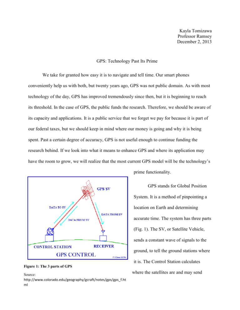
Kayla Tomizawa Professor Ramsey December 2, 2013 GPS: Technology Past Its Prime We take for granted how easy it is to navigate and tell time. Our smart phones conveniently help us with both, but twenty years ago, GPS was not public domain. As with most technology of the day, GPS has improved tremendously since then, but it is beginning to reach its threshold. In the case of GPS, the public funds the research. Therefore, we should be aware of its capacity and applications. It is a public service that we forget we pay for because it is part of our federal taxes, but we should keep in mind where our money is going and why it is being spent. Past a certain degree of accuracy, GPS is not useful enough to continue funding the research behind. If we look into what it means to enhance GPS and where its application may have the room to grow, we will realize that the most current GPS model will be the technology’s prime functionality. GPS stands for Global Position System. It is a method of pinpointing a location on Earth and determining accurate time. The system has three parts (Fig. 1). The SV, or Satellite Vehicle, sends a constant wave of signals to the ground, to tell the ground stations where it is. The Control Station calculates Figure 1: The 3 parts of GPS Source: http://www.colorado.edu/geography/gcraft/notes/gps/gps_f.ht ml where the satellites are and may send correction information to the satellite. The consumer unit is the Receiver, and it merely waits for time and coordinates from the satellite. [1] There are several types of receivers and depending on whether or not the receiver is moving or what sort of signal strength it needs, the receiver will be built differently. For example, receivers on airplanes are designed to be able to receive a signal in a spherical direction, which allows a plane to receive a GPS signal even while upside down. Other receivers are placed around Earth to measure how the plate tectonics move for obvious weather and disaster predictions. The most well-known receivers are those in people’s phones, which are built under size and power consumption constraints. Smart phones constantly use GPS, because phones rely on GPS for accurate time-telling. Turning on the tracking function on a smart phone, however, will require the phone to find the GPS signal and calculate its specific location, which uses extra processing power. This is why it is a manual function on smart devices. The positioning algorithm is based on the concept of triangulation (Fig. 2). At any time, the distance from a satellite can easily be calculated. The satellite sends off a radio signal, or in other words, a simple beep. The receiver, either on the control side or on the consumer side, can calculate the time in between the beeps, and multiply it by the speed of the signal, which is about the speed of Figure 2: Triangulation Method light as seen in the graphic, and solve for the Source: http://gpstrianguler.blogspot.com/ distance. This equation only gives the distance from the satellite. Calculations from a single satellite attain a spherical range of solution points. Two calculations from two satellites will result in a circle of possible location points. The solution circle is shown as the black circle in the visual above. Three calculations from three satellites will result in only two possible location points, shown as black dots on the black circle in the visual. Typically, one of these two points will be out of range of the surface of the Earth, which leaves only one obvious answer. In general, receivers wait for four satellite signals to be sure of its position on Earth. The United States government owns about thirty satellites, creating a constellation that ensures coverage of at least four satellites simultaneously at any one place all over the world. [2] The method and math seem fairly simple and straightforward. With thirty satellites in the sky, why do we sometimes see error on our GPS devices? Why do we continue to see improvements in GPS tracking? The first system launched had an accuracy of within 250 meters [3]. The system the government is currently launching, GPS III, includes accurate enough models to ensure coordinates within one meter. This summer, the Air Force launched two GPS III satellites into space. Awarded the $5 billion dollar contract five years ago, Lockheed Martin leads the satellite update [4]. The goals are to make GPS accurate enough to track a position within one meter. In order to meet this goal, engineers have upgraded the orbit models to account for more errors and they’ve designed the new satellites that will last longer and send more signals. To display the satellite orbit models on paper, we may draw the projected path of the satellite orbit. We draw it as a perfect ellipse. We also draw the Earth as a perfect sphere, and we leave out all the other planets and celestial bodies in the solar system. In reality, the satellite’s orbit is not an ellipse, the Earth is not spherical, and there are definitely large bodies with enormous amounts of gravitational force affecting our planet and the satellites orbiting it. A large part of the research behind GPS is put towards calculating the exact path of the satellite’s orbit, based on the gravitational fluctuations from the moving solar system. Since a satellite is out in space, it is impossible to ever be certain where it is, so scientists take measurements and use filtering algorithms to determine where the satellites most likely are. [5] What may be the least accredited, but the most crucial contribution of GPS is time keeping. The satellites help measure the speed of the Earth’s rotation. We measure our days with sunrises and sunsets, but the sun does not orbit around the Earth. The Earth spins and orbits around the sun; therefore, our sense of time is based on the rotational and orbital speed of the Earth. GPS is what allows us to keep accurate track of leap years, even leap seconds, which keep our banks and transportation running precisely. The satellites’ trajectories are used in helping measure the speed of the Earth’s rotation. Therefore, all the corrections calculated for the trajectory based on the gravitational pulls from other celestial bodies must also be used to calculate the time delay. [5] Those are just some of the problems the satellite’s orbit faces. There are also obstacles the signals must face. When a receiving device cannot find signal in an underground parking structure, that’s because the radio signal cannot travel through several feet of concrete. On the other extreme, any particle, even air and light, affects the pathway of the signal. Signal delay caused by particles inside the Earth’s atmosphere is called tropospheric delay [6]. Signals received from satellites further from the zenith direction travel slower than signals received from directly above the satellite (Fig. 3). The more of Earth’s atmosphere the signal must travel through, the longer it will take to get to the receiver, resulting in a positional error. While the error caused by tropospheric delay is very small compared to the satellite orbit corrections, the process to calculate the tropospheric delay is tedious and expensive. Measurements from all over the Earth during different times and weather conditions at different levels of atmosphere must constantly be taken in order for the delay calculations to be useful. The Figure 3: Tropospheric Delay correction obtained from calculating the Source: tropospheric delay may not seem worth the http://www.colorado.edu/geography/gcraft/notes/gps/gps_f. html work. It’s a new requirement for GPS III [5] and if there were to be a next generation GPS, there would need to be more research in this area. Past the one meter accuracy GPS III promises, the correction is not worth the cost. The satellite trajectory and signal delays are examples of problems the government tackles to build a more accurate GPS model. NASA, along with the help of the IERS, or the International Earth Reference Systems Service, takes measurements of the environment outside and inside the Earth’s atmosphere to calculate better models of the satellites and signals. Aside from these, engineers work to develop satellites and launch systems. Most of the money spent is in building and launching the satellites. That’s what Lockheed Martin is contracted to do [4]. Development and launching will cost $5 billion alone. The measurements and research are done by NASA and a number of other companies, which are paid separately from Lockheed Martin. We can now begin to sense how immense the GPS project is. The final general research topic within GPS is signal processing. The satellites send down simple radio signals to communicate with the control stations and receivers. How is it that receivers know which signal to look for, or how does the government protect the signal? The satellite’s signal is made of three waves: a carrier, the data, and an encryption code. The carrier is just the frequency the signal rides on. The data is the positional information the satellite sends down, and the encryption code is how the receiver finds the right signal. The receiver knows the exact code and the carrier frequency so that it may match it and read the data hidden in the signal modulation. [7] GPS III satellites will each send four signals, one shared globally by all nations, one specifically for military, and two extra for civilians. With each satellite sending multiple signals on different frequencies, they could be used to error check against each other, aiding in accuracy. Multiple signals can also be used to strengthen the signal, so that the receiver may find the signal easier and quicker. For the military signal, engineers have added a stronger encryption code and increased the power capacity. This aspect of the project is worth researching further. The encryption method is essential to the safety of our nation. Both the encryption and adding signal capacity is an easy and inexpensive fix. Once the satellites are launched (part of Lockheed’s contract), the receivers must be retrofitted to be able to search for the new signals. What this means is that consumer will need to buy a new receiver, but that would fall under the commercial aspect of GPS. It will not be government funded, and therefore, is not a shared cost among the public. Another obstacle satellite signals face are reflective surfaces. Especially in urban areas, the signals will bounce off buildings and cars, creating a multipath effect [7]. Mainly GPS devices in their cars deal with multipath effects. The receiver moves so that there is no way to predict the possible reflections of the signal. This is an example of a commercial product problem. The GPS receiver must install software to correct multipath effects. The satellite and the government control stations are not equipped to solve each individual receiver problem. GPS III has several promises for exciting breaks in technology to come in the next ten years. This includes, Amazon Prime Air which is a drone delivery service, and automated vehicles [7]. California has already passed laws legalizing automated cars [8]. Along with the new consumer market that will open up, there will be great advances in the safety of transportation. GPS will be able to track how much cargo trains stretch and contract with extreme weather, minimizing crashes. However, the use for such an accurate GPS stops here. There seems to be no use for the public to have accuracy closer than a meter. Past that point, GPS becomes a terribly dangerous weapon. The military backs up GPS research to make sure the bombs they send hit their target and not innocent citizens. Closer than a meter, though, makes way for precise weapons such as lasers. It’s something out of a sci-fi film, but we should consider the dangers of the research before we support it. Medical uses, such as tracking the body, or business uses, such as indoor navigation, may argue for more accurate GPS models. To this we should refer to how GPS works. The main challenge with GPS is the fact that the satellites, or the points of reference, are out of our view. We cannot ever be absolutely sure where the satellites are, since we could never physically measure their positions. Had we been able to, the entire system would not need NASA’s continued research and data collections from the past few decades to predict the solar system orbits. For indoor systems, or even systems completely enclosed within the Earth’s atmosphere, the calculations for GPS becomes much simpler; the cost of the system becomes much simpler, and the exact position coordinates are much more easily attainable. In fact, businesses are already investing in systems for indoor tracking, as seen with the Caesar’s Palace application [10]. This doesn’t mean that we should not continue to learn about GPS. It is necessary to continue researching encryption methods in order to keep our military signals out of the wrong hands and project our soldiers on the field. If we are hiding somewhere, we don’t want the enemy to be able to detect our signal. Regardless of whether or not we agree with the war, it would be for the safety of our soldiers that are already on the field. However, this is not the same as continuing to calculate more accurate GPS signals. What it may become is an extension of the Cold War. Centimeter accurate GPS is a way to fuel the creation of massive weapons. In the end, it will terrorize citizens, similarly to nuclear weapons. Hopefully we can learn from our mistakes and see some technologies as more dangerous to pursue than to create. It is not necessary to continue pushing the boundaries of GPS accuracy, and once the current GPS III contract is over, we should push to cease heavy funding for research. Works Cited [1] Peter H. Dana. (2000, May 1). Global Positioning System Overview. [Online]. Available: http://www.colorado.edu/geography/gcraft/notes/gps/gps_f.html [2] National Coordination Office for Space-Based Position, Navigation, and Timing. (2013, October 22). Space Segment. [Online]. Available: http://www.gps.gov/systems/gps/space/ [3] Mary E. Reece. (2000 April). Navigation History. [Online]. Available: http://infohost.nmt.edu/~mreece/gps/cover.html [4] Lockheed Martin Corporation. (2013). Global Position System. [Online]. Available: http://www.lockheedmartin.com/us/products/gps.html [5] Gérard Petit and Brian Luzum, “Technical Notes No. 36” in IERS Conventions, Frankfurt am Main, 2010, pp. 33-67. [6] Wang Xinlong. (1929). The applicability analysis of troposphere delay error model in GPS positioning. [Online]. Available: http://www.emeraldinsight.com/journals.htm?articleid=1810553&show=html [7] Timothy S. Stombaugh. Unraveling the GPS Mystery. [Online]. Available: http://ohioline.osu.edu/aex-fact/0560.html [8] Adario Strange. (2013, December 1). Amazon Unveils Flying Delivery Drones on '60 Minutes. [Online]. Available: http://mashable.com/2013/12/01/amazon-unveils-flyingrobot-delivery-drones/ [9] Arion McNicoll and Nick Glass. (2013, June 7). Future of transport is self-driving cars, says GPS inventor. [Online]. Available: http://www.cnn.com/2013/06/07/tech/selfdriving-cars-inventor-gps/ [10] Dean Takahashi. (2011, November 1). CST demos technology for tracking mobile devices indoor. [Online]. Available: http://venturebeat.com/2011/11/01/csr-demostechnology-for-tracking-mobile-devices-indoors/


