Geography_Location_Knowledge_MTP(1)
advertisement
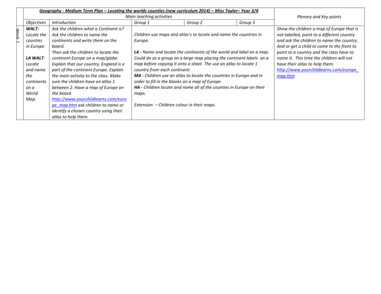
Week 1 Geography - Medium Term Plan – Locating the worlds counties (new curriculum 2014) – Miss Taylor– Year 3/4 Main teaching activities Objectives Introduction Group 1 Group 2 Group 3 WALT: Ask the children what a Continent is? Children use maps and atlas’s to locate and name the countries in Locate the Ask the children to name the Europe. counties continents and write them on the in Europe board. LA - Name and locate the continents of the world and label on a map. Then ask the children to locate the Could do as a group on a large map placing the continent labels on a LA WALT: continent Europe on a map/globe. map before copying it onto a sheet. The use an atlas to locate 1 Locate Explain that our country, England is a country from each continent. and name part of the continent Europe. Explain MA - Children use an atlas to locate the countries in Europe and in the the main activity to the class. Make order to fill in the blanks on a map of Europe. continents sure the children have an atlas 1 HA - Children locate and name all of the counties in Europe on their on a between 2. Have a map of Europe on maps. World the board. Map. http://www.yourchildlearns.com/euro Extension – Children colour in their maps. pe_map.htm ask children to name or identify a chosen country using their atlas to help them. Plenary and Key points Show the children a map of Europe that is not labelled, point to a different country and ask the children to name the country. And or get a child to come to the front to point to a country and the class have to name it. This time the children will not have their atlas to help them. http://www.yourchildlearns.com/europe_ map.htm Week 2 WALT Identify and research main capital cities of countries in Central Europe Ask children to remind you what a continent is. Name and locate them on a world map. Show the children a map of central Europe and ask the children to name the countries. http://www.sheppardsoftware.com/ Europe/Eur_G0_1024_768.html Explain to the children that today we will be focusing on the capitals of countries in central Europe show the children these to help them identify what they are. http://www.sheppardsoftware.com/ Europe/Eur_GL_Caps_1024_768.htm l The children will create a poster in mixed ability groups for each capital city in Central Europe. Split the class into 8 teams (mixed ability) Get one child to choose at random the name of a capital city. (Children can give their team a name) That will be the capital city for that group. Together their poster must include: o A title of the capital city which stands out. 5 points o Explain what country it is the capital of 5 points o A map displaying the capital city 5 points o Information about the country (5 sentences) 10 points o Famous landmarks in the city. 15 points o At least 3 different pictures of landmarks in the city. 10 points o 5 Sentences about the history of the city. 10 points o Use of colour 10 points TEAMWORK! 30 points Explain to the children that each criteria is worth a maximum number of points. Also explain that teamwork is the most important. That means working together as a team not falling out and all contributing to the poster and not letting 1 or 2 do all the work. The team with the most points wins a prize. Explain that each group will be given 15 mins only in the ICT suite to do any research they can and print off anything to add to their poster. Each group will be provided with books and hand outs on their capital city to help them. o Germany – Berlin http://www.visitcapitalcity.com/euro pe/berlin-germany Switzerland – Bern http://www.visitcapitalcity.com/euro pe/bern-switzerland Liechtenstein – Vaduz http://www.visitcapitalcity.com/euro pe/Vaduz-Liechtenstein Austria – Vienna http://www.visitcapitalcity.com/euro pe/vienna-austria Hungary – Budapest http://www.visitcapitalcity.com/europe /budapest-hungary Czech Republic - Prague http://www.visitcapitalcity.com/euro pe/prague-czech-republic Slovakia – Bratislava http://www.visitcapitalcity.com/euro pe/bratislava-slovakia Poland – Warsaw http://www.visitcapitalcity.com/euro pe/warsaw-poland Judge the children’s posters out against the marking criteria total out of 100. Children present their poster and explain what they have found out. Could ask TA to judge the work in secret against criteria to fairly determine a winner. Could possibly have joint winners. Week 3 WALT: Locate and name counties in the British isles with their capitals. Ask the children what they did last lesson. Then get the children to name the countries in central Europe along with their capitals. Ask the children what continent we live in. Then ask what part of Europe we live in. Show the children a map of the British isles. Ask the children if they can identify the countries and of the British Isles. Also ask if any of the children have visited these places and what it was like. Go over with the children where the countries are and what the capital cities are called. England – London Scotland – Edinburgh Wales – Cardiff Northern Ireland – Belfast Rep of Ireland - Dublin Explain main session to the children. Resources: http://www.yourchildlearns.com/mega maps/print-europe-maps.html Clue map http://www.yourchildlearns.com/onlin e-atlas/british-isles-map.htm Give the children a piece of the jigsaw puzzle (map 6x6 36 sheets) they must colour it in using crayons provided. Take the children in the hall with their jigsaw piece the class must put the jigsaw of the British isles. Once the children have completed the jigsaw they must each table group must use the large labels provided to label the correct countries in the British Isles and then the Capital cities. Display the clue map to help the children. 2nd half of the session Children will then use their knowledge countries and capitals of the British Isles to label a smaller map in their books. LA – Label a map of the British Isles with labels already provided. TA to support group. MA – Children label a blank map without labels provided and write sentences about the British Isles e.g. England is a country in the British isles. London is the capital of England. HA – Children label a blank map without labels and the children also use atlas’s or with use of computers in the ICT suite to find more information about counties in the British isles e.g. population, climate and the children write sentences based on what they have found. LT to work with group initially. Test the children’s ability to locate countries and capitals in the British Isles using the giant map that the children created during the lesson. Get children to come up to the map and but the labels in the correct place. Week 4 WALT: Locate and name major rivers in the UK. Ask children to recap what they did last lesson by naming and locating the countries of the British Isles on a map. Then explain that the children today we will be focusing on the rivers in the British Isles. Can they name any rivers in the British Isles? Show the children a map of the British Isles http://gwydir.demon.co.uk/jo/maps/uk rivers/ highlight the rivers and what country they are in. The children will label the different Rivers on their given maps. LA – Children will have a larger map and have the labels printed out ready to stick in the right place. This will be completed as a group with adult support. MA – Children will have a larger map and have the labels printed out ready to stick in the right place. This will be completed as a group independently. HA – Children will have a small map on which they must draw the rivers and label them using a guide. 2nd half of the session Children will be put into mixed ability groups. Ask children to name a river they remember from the1st part of the lesson and state what country it is in. Give each group the name of a river and the groups must complete a fact file on the river. (see sheets for facts on the rivers and pictures) explain the children must include all this information on their fact file. Ask children to complete the quiz in groups giving each team points for each correct answer. http://gwydir.demon.co.uk/jo/maps/ukrive rs/
