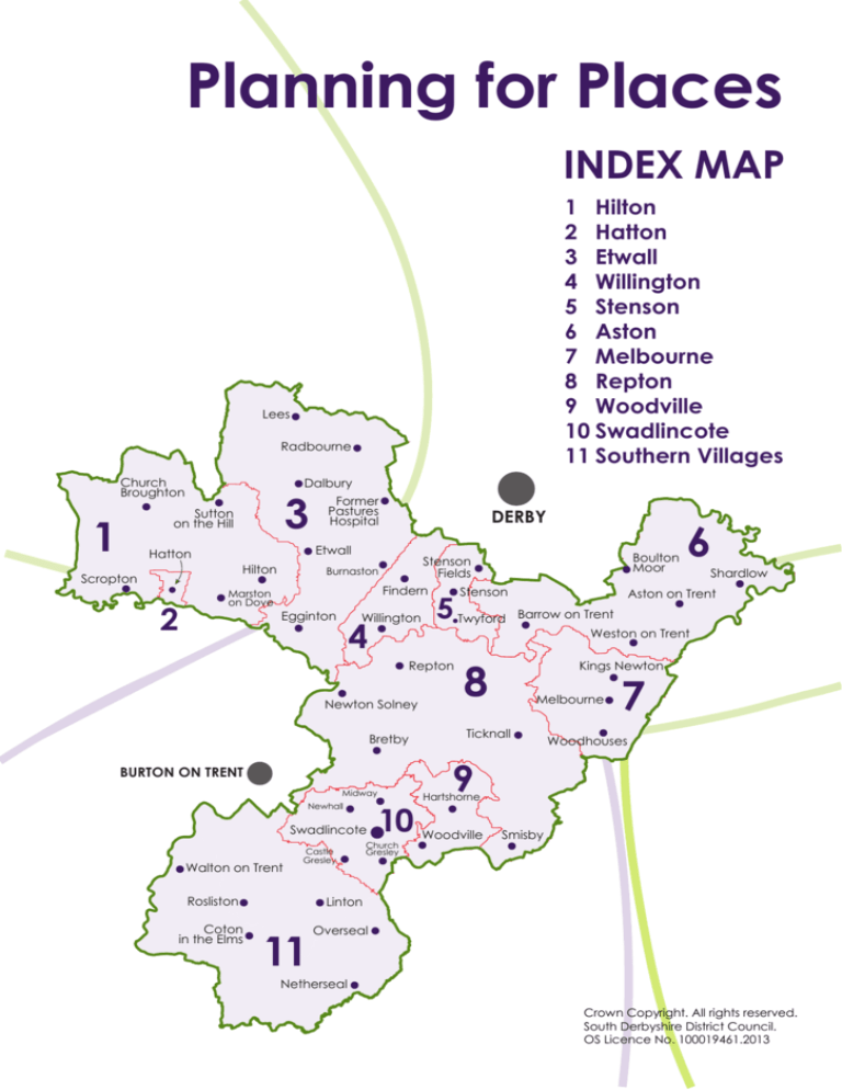
Planning for Places
INDEX MAP
1 Hilton
2 Hatton
3 Etwall
4 Willington
5 Stenson
6 Aston
7 Melbourne
8 Repton
9 Woodville
10 Swadlincote
11 Southern Villages
Lees
Radbourne
Church
Broughton
Dalbury
3
Sutton
on the Hill
1
DERBY
Etwall
Hatton
Hilton
Scropton
2
Former
Pastures
Hospital
Marston
on Dove
Burnaston
Findern
Egginton
Willington
4
Newton Solney
Bretby
BURTON ON TRENT
Newhall
Swadlincote
Walton on Trent
Castle
Gresley
Rosliston
Coton
in the Elms
Stenson
5 Twyford
Repton
Midway
Boulton
Moor
Stenson
Fields
10
Church
Gresley
8
6
Shardlow
Aston on Trent
Barrow on Trent
Weston on Trent
Kings Newton
Melbourne
Ticknall
7
Woodhouses
9
Hartshorne
Woodville
Smisby
Linton
11
Overseal
Netherseal
Crown Copyright. All rights reserved.
South Derbyshire District Council.
OS Licence No. 100019461.2013
5
STENSON AREA
Description
The area predominantly rural in character, but also includes suburban
development on the fringe of Derby at Sinfin. The A50 crosses the area to
the south of Sinfin, whilst the Birmingham-Derby passenger railway line
passes to the west and the Donington freight railway line passes from
west to east.
The Trent and Mersey Canal, a conservation area, also passes through
the area, the pub and marina at Stenson Bubble being a popular local
destination. A further conservation area has been designated at the
small village of Twyford. The southern boundary of the area is largely
defined by the River Trent.
The residential area at Sinfin is served by frequent bus services to Derby
City Centre and local shopping services and facilities are available at the
district centre, just within the city boundary. The main route into Derby is
Stenson Road, which experiences congestion at peak times, particularly
at the signal-controlled railway bridge. On the fringe of Sinfin, a new
strategic housing development is currently under construction.
Stenson Area - Number of dwellings and residents in 2001
and 2011
Vision
Protect the rural character and heritage assets of the area whilst
providing for housing growth on the Derby fringe.
Objective 1:
Protect the rural character of the area.
Objective 2:
Provide for housing development on the fringe of Sinfin.
173
25
Objective 3:
Protect heritage assets
Objective 4:
Support the economic vitality of the area.
Objective 5:
Ensure the delivery of the South Derby Integrated
Transport Link phase 1 to support new strategic
development.
Objective 6:
Protect land that may be needed to enable the future
provision of the South Derby Integrated Transport Link,
phase 2.
Objective 7:
Improve accessibility by sustainable transport modes.
Settlements in the area
Urban Extension: Stenson Fields
Rural Village:
Stenson, Twyford
SUMMARY OF POLICIES:
Housing
•
•
•
Sites with consent – Primula Way: 145 dwellings
Stenson Fields: 487 dwellings
Wragley Way: 1,950 dwellings (1,180 of which are expected to
come forward during the plan period. The site is also covered by the
Aston Area)
• Primula Way: 366 dwellings
• Stenson Fields estate: 98 dwellings
Employment
•
Allow for the provision of appropriate tourist accommodation and
other facilities.
• Allow for small scale farm diversification.
Transport
•
Protect land needed for the development of the South Derby
Integrated Transport Link phase 1
• Protect land that may be needed to enable the future provision of
the South Derby Integrated Transport Link Road phase 2.
• Protect land that may be needed to enable the future provision of
a passenger railway station on the Derby-Birmingham railway line.
• Expand and improve local cycleways and multi-user trails as part of
a wider route network.
174
26
Green Infrastructure
•
Protect the integrity of Derby City’s Green Wedges through control
of development within South Derbyshire.
• Protect and enhance green infrastructure, including the landscape
and ecology corridors of the Trent and Mersey Canal and the River
Trent.
175
27
)
TKEY
MICKLEOVER
South Derby Integrated Transport
Link, Phase 1
Phase 1 road to join T12
BURNASTON
South Derby Integrated
Transport
Link, Phase 2
Derby City Preferred Growth Strategy
Housing Sites
DERBY CITY
Strategic Employment Location
Green Wedges
Conservation Area
HP12
South Derbyshire District Boundary
Stenson Area Boundary
HP16
HP16
Housing Sites with Planning Permission
HP17
Housing Allocations
ETWALL
HP19
HP15
FINDERN
SINFIN
STENSON
FIELDS
HP15
A50
(T)
A50(T)
HP15
)
A50( T
ASTON AREA
ETWALL AREA
HP15
STENSON
STENSON Area
A50( T )
WILLINGTON &
FINDERN AREA
TWYFORD
WILLINGTON
A51
32
A5132
A5
A5132
BARROW
ON TRENT
8(
T)
132
A3
6(
A51
REPTON AREA
REPTON
NORTH
Crown Copyright. All rights reserved. South Derbyshire District Council. OS Licence No. LA100019461.2013
STENSON Area
HOUSING
POLICY
HOUSING SITE
HP15
Wragley Way
HP16
Primula Way
HP17
Stenson Fields Estate
HP19
Stenson Fields
Lees
Radbourne
Church
Broughton
Dalbury
Former
Pastures
Hospital
Sutton
on the Hill
DERBY
Etwall
Hatton
Hilton
Scropton
Marston
on Dove
Findern
Egginton
Boulton
Moor
Stenson
Fields
Burnaston
Stenson
Twyford Barrow on Trent
Weston on Trent
Willington
Kings Newton
Repton
Melbourne
Newton Solney
Bretby
Ticknall
BURTON ON TRENT
Midway
Newhall
Swadlincote
Walton on Trent
Rosliston
Coton
in the Elms
Castle
Gresley
Church
Gresley
Linton
Overseal
Netherseal
Hartshorne
Woodville
Shardlow
Aston on Trent
Smisby
Woodhouses
6
ASTON AREA
Overview
The area has a predominantly rural feel to it though the area does adjoin
Derby City along its northern boundary. The A50 trunk road crosses the
area from east to west, with a spur heading northwards toward the A6 and
A52. The southern boundary of the area is defined by the River Trent and
much of the area around the Trent is susceptible to flooding. A large
proportion of the north east part of the area forms the southern boundary
of the Nottingham-Derby Green Belt. The area contains the key village of
Shardlow and a number of other small settlements.
Aston area contains various heritage assets including conservation areas at
Shardlow, Aston-on-Trent, Barrow-on-Trent and along the length of the Trent
and Mersey Canal. The route of the former Derby Canal, now a local
wildlife site, extends northwards from Swarkestone into the city. There are
also historic parks and gardens at Swarkestone and Elvaston. Swarkestone
Causeway, which extends southwards across the Trent floodplain,
represents a scheduled Ancient Monument and follows an alignment not
suited to the volume and mix of traffic using it. A proposal to address this
issue is included on a list of potential schemes for further assessment in the
Derbyshire Local Transport Plan.
The area is within reach of business and industrial areas in Derby City and
within Leicestershire, such as East Midlands Airport and the East Midlands
Distribution Centre. To a large extent, the area is reliant on retail and other
services and facilities in Derby and other settlements outside the area.
National Cycle Route 6 passes through the area, connecting to the
network of cycle routes within Derby City.
Aston Area - Number of dwellings and residents in 2001
and 2011
179
1
Vision
To protect the rural character and heritage assets of the area whilst
providing for housing and employment growth on the edge of Derby and
smaller scale housing development at Aston-on-Trent.
Objective 1:
Protect the rural character of the area.
Objective 2:
Meet housing needs through new residential development
on the Derby fringe and smaller scale residential
development at Aston-on-Trent.
Objective 3:
Support the economic vitality of the area.
Objective 4:
Ensure the provision of the Southern Derby Link Road,
Phase 1 to support new strategic development.
Objective 5:
Protect heritage assets and provide for the reinstatement
of the former Derby Canal.
Objective 6:
Expand and improve sustainable transport choices.
Objective 7:
Maintain open land extending from Derby City into South
Derbyshire.
Settlements in area
Derby Urban Extensions
Key Village:
Shardlow
Local Village: Aston-on-Trent, Weston-on-Trent
Rural:
Elvaston, Thulston, Swarkestone, Barrow-on-Trent
SUMMARY OF POLICIES
Housing
•
•
•
•
Sites with consent – Boulton Moor: 1,058 dwellings
Boulton Moor Phase 2 & 3 – 890 dwellings
Chellaston (Holmleigh Way & Chellaston Fields) – 600 dwellings
Wragley Way - 1,950 dwellings (1,180 of which are expected to come
forward in the plan period. The site is also covered by the Stenson
Area)
• Former Aston Hall Hospital – 100 dwellings
• Further small scale residential sites may be identified in Part 2 of the
Local Plan across the area guided by the Settlement Hierarchy
• Potential Reserve site - Lowes Farm
180
2
Employment:
•
Global Technology Cluster (GTC) extension – 20 ha, is a strategic
employment location. The GTC is a proposed business development
at Sinfin Moor in Derby City, with capacity to expand southwards into
South Derbyshire.
• Allow for small scale farm diversification and the provision of
appropriate tourist and leisure facilities.
• Protect the route of the former Derby Canal.
Transport
•
•
•
Protect land needed for the development of the South Derby
Integrated Transport Link, Phase 1 (Phase 2 is considered in Stenson
and Willington & Findern areas)
Expand and improve local cycleways and multi-user trails as part of
a wider route network.
Protect land that may be needed for the future development of a
park and ride facility at Boulton Moor.
Environment
•
Enhance and expand green infrastructure, including the landscape
and ecology corridors of the Trent and Mersey Canal and the River
Trent.
• Protect Elvaston Country Park and Swarkestone Park and Garden.
• Protect the integrity of green wedges extending from Derby City.
Green Belt:
•
Maintain the principal of the section of Nottingham-Derby Green Belt
within the District.
181
3
Derby City Preferred Growth Strategy
Derby
Employment Site
T12 Link Road
OCKBROOK
Strategic Employment Location
South Derby Integrated Transport
Link, Phase 1
Canal Realignment
Green Belt
South Derby Integrated Transport
Link, Phase 2
Green Belt
in
EREWASH
BOROUGH COUNCIL
Green Wedges
Derby City Preferred Growth Strategy
Housing Sites
Conservation Area
Derby Sites with current planning
applications
Historic Park and Garden
Housing Sites with Planning Permission
South Derbyshire District Boundary
Housing Allocations
Aston Area Boundary
Park and Ride
NORMANTON
DRAYCOTT
ELVASTON
HP12
DERBY CITY
HP16
HP16
ALLENTON
THULSTON
HP17
HP15
FINDERN
HP13
HP13
A6( T )
HP19
HP13
SINFINNEW ROAD
WILL JOIN
T12 LINK
STENSON
FIELDS
HP15
BOULTON
MOOR
SHARDLOW
WILLINGTON &
FINDERN AREA
A5
E5
CHELLASTON
(T
HP18
EY C
HP14
A50(T )
ANA
L
0
A5
)
NORTH WEST
LEICESTERSHIRE
DISTRICT COUNCIL
ASTON
ON TRENT
SWARKESTONE
HP8
WESTON
ON TRENT
BARROW
ON TRENT
)
AL
STENSON AREA
MER
S
0( T
GREAT
WILNE
AN
TRENT &
HP15
HP15
ASTON Area
KEY
N
TRE
T
SE
ER
&M
YC
CASTLE DONINGTON
REPTON AREA
MELBOURNE AREA
INGLEBY
REPTON
FOREMARKE
NORTH
MILTON
Crown Copyright. All rights reserved. South Derbyshire District Council. OS Licence No. LA100019461.2013
MELBOURNE
ASTON Area
HOUSING
POLICY
HOUSING SITE
HP15
Wragley Way
HP18
Land off Holmleigh Way
HP14
Chellaston Fields
HP13
Boulton Moor Phase 1
Boulton Moor Phase 2
Boulton Moor Phase 3
HP8
Aston Hall Hospital, Aston on Trent
EMPLOYMENT
POLICY
EMPLOYMENT SITE
E5
The Global Technology Cluster
extension – safeguarded site for
employment
Lees
Radbourne
Church
Broughton
Dalbury
Former
Pastures
Hospital
Sutton
on the Hill
DERBY
Etwall
Hatton
Hilton
Scropton
Marston
on Dove
Findern
Egginton
Boulton
Moor
Stenson
Fields
Burnaston
Stenson
Twyford Barrow on Trent
Weston on Trent
Willington
Kings Newton
Repton
Melbourne
Newton Solney
Bretby
Ticknall
BURTON ON TRENT
Midway
Newhall
Swadlincote
Walton on Trent
Rosliston
Coton
in the Elms
Castle
Gresley
Church
Gresley
Linton
Overseal
Netherseal
Hartshorne
Woodville
Shardlow
Aston on Trent
Smisby
Woodhouses
7
MELBOURNE AREA
Overview
The area is rural in character, containing the Key Service Village of
Melbourne and a number of smaller settlements. It contains many
heritage assets including numerous listed buildings, conservation areas at
Melbourne and Stanton by Bridge and a historic park and garden at
Melbourne Hall. The area lies partly within the National Forest and also
contains the Staunton Harold Reservoir.
Melbourne contains the second most important shopping centre in the
district and a small industrial estate. The area is also attractive to tourists.
Close by, but beyond the South Derbyshire boundary, lays the important
employment sites of East Midlands Airport and the East Midlands
Distribution Centre.
The A514 connects Melbourne to Derby via the Swarkestone Causeway,
a scheduled Ancient Monument that follows an alignment not suited to
the volume and mix of traffic using it. Options have been considered for
the development of an alternative route and the Derbyshire Local
Transport Plan includes the proposal on a list of potential major schemes
for further assessment. National Cycle Route 6 runs to the north east of
Melbourne connecting to Derby and rural Leicestershire.
Melbourne Area - Number of dwellings and residents in
2001 and 2011
Vision
To protect and enhance the rural character and heritage assets of the
area, taking advantage of the presence of the National Forest, whilst
maintaining the role of Melbourne as a Key Serviced Village.
185
17
Objective 1:
Protect the rural character of the area.
Objective 2:
Protect heritage assets and the historic character of the
conservation areas.
Objective 3:
Accommodate appropriate tourism and leisure facilities,
taking advantage of the location of part of the area
within the National Forest.
Objective 4:
Protect the vitality and viability of Melbourne shopping
centre.
Objective 5:
Improve accessibility by sustainable transport modes.
Objective 6:
Support the economic vitality of the area.
Settlements in the area
Key Village:
Rural Villages:
Melbourne
Stanton by Bridge, Kings Newton, Woodhouses
SUMMARY OF POLICIES:
Housing
•
•
No strategic scale growth proposed in the Melbourne Area.
Further small scale residential sites may be identified in Part 2 of the
Local Plan across the area guided by the Settlement Hierarchy.
Employment
•
•
No strategic scale growth proposed
Allow the provision of appropriate tourist accommodation and
other facilities, taking advantage of the location of part of the area
within the National Forest.
• Allow small scale farm diversification.
Transport
•
Continue the establishment of cycleways and multi-user trails as part
of a wider route network.
Environment
•
Enhance and expand green infrastructure, taking advantage of the
location of part of the area within the National Forest.
186
18
Shopping
•
Protect existing shopping and services within Melbourne town
centre.
Leisure and Recreation
•
Support new leisure, recreation and community development at
Cockshut Lane and the Assembly Rooms.
187
19
A50(T)
A50(
T)
CHELLASTON
DERBY CITY
STENSON
Public Safety Zone
(Nottingham East Midlands Airport - Runway 09 Approach)
0( T
Area within The National Forest
ASTON ON TRENT
Conservation
Area STENSON AREA
WILLINGTON
&
FINDERN AREA
Historic Park and Garden
Melbourne Area Boundary
A5132
SWARKESTONE
WESTON ON TRENT
BARROW
ON TRENT
INGLEBY
STANTON BY BRIDGE
MILTON
KINGS NEWTON
FOREMARKE
REPTON
REPTON AREA
B5
87
MELBOURNE
B587
WOODHOUSES
NORTH WEST
LEICESTERSHIRE
DISTRICT COUNCIL
B587
TICKNALL
BREEDON
ON THE HILL
14
A5132
TWYFORD
ASTON AREA
A5
WILLINGTON
South Derbyshire District Boundary
)
A5
A50(T)
MELBOURNE Area
KEY
FINDERN
CALKE
NORTH
Crown Copyright. All rights reserved. South Derbyshire District Council. OS Licence No. LA100019461.2013
MELBOURNE Area
THERE ARE NO STRATEGIC HOUSING OR EMPLOYMENT POLICIES
ASSOCIATED WITH THIS AREA
Lees
Radbourne
Church
Broughton
Dalbury
Former
Pastures
Hospital
Sutton
on the Hill
DERBY
Etwall
Hatton
Hilton
Scropton
Marston
on Dove
Findern
Egginton
Boulton
Moor
Stenson
Fields
Burnaston
Stenson
Twyford Barrow on Trent
Weston on Trent
Willington
Kings Newton
Repton
Melbourne
Newton Solney
Bretby
Ticknall
BURTON ON TRENT
Midway
Newhall
Swadlincote
Walton on Trent
Rosliston
Coton
in the Elms
Castle
Gresley
Church
Gresley
Linton
Overseal
Netherseal
Hartshorne
Woodville
Shardlow
Aston on Trent
Smisby
Woodhouses

