Directions to Rancho Casitas from U.S. Border via Ensenada, Mexico
advertisement
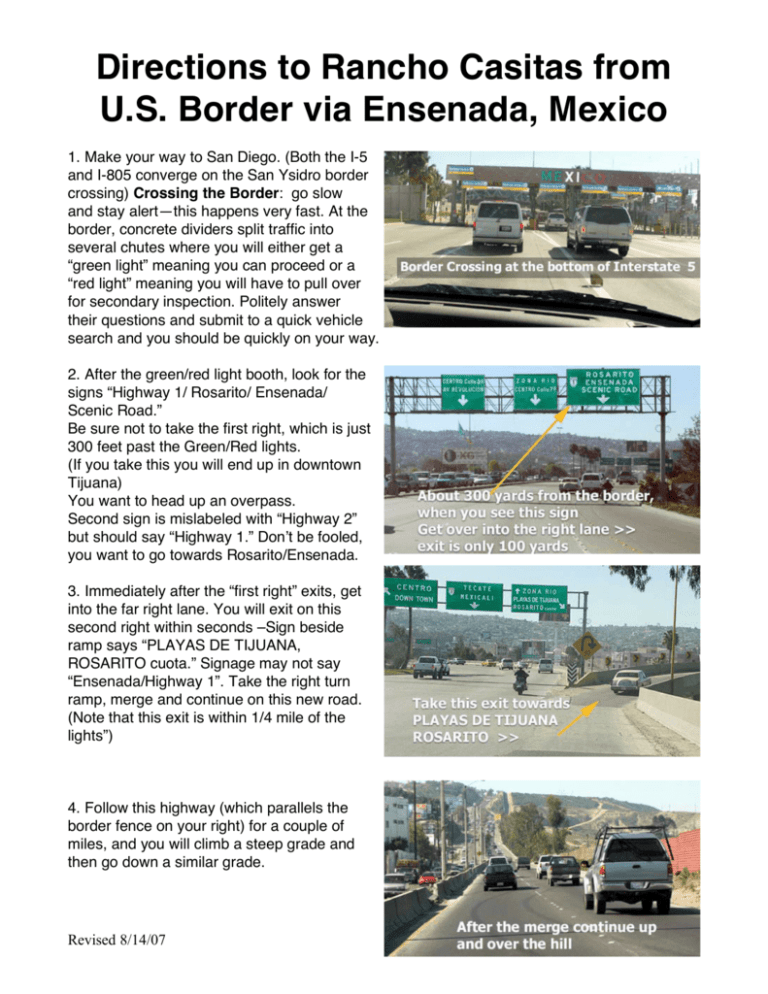
Directions to Rancho Casitas from U.S. Border via Ensenada, Mexico 1. Make your way to San Diego. (Both the I-5 and I-805 converge on the San Ysidro border crossing) Crossing the Border: go slow and stay alert—this happens very fast. At the border, concrete dividers split traffic into several chutes where you will either get a “green light” meaning you can proceed or a “red light” meaning you will have to pull over for secondary inspection. Politely answer their questions and submit to a quick vehicle search and you should be quickly on your way. 2. After the green/red light booth, look for the signs “Highway 1/ Rosarito/ Ensenada/ Scenic Road.” Be sure not to take the first right, which is just 300 feet past the Green/Red lights. (If you take this you will end up in downtown Tijuana) You want to head up an overpass. Second sign is mislabeled with “Highway 2” but should say “Highway 1.” Dont be fooled, you want to go towards Rosarito/Ensenada. 3. Immediately after the “first right” exits, get into the far right lane. You will exit on this second right within seconds –Sign beside ramp says “PLAYAS DE TIJUANA, ROSARITO cuota.” Signage may not say “Ensenada/Highway 1”. Take the right turn ramp, merge and continue on this new road. (Note that this exit is within 1/4 mile of the lights”) 4. Follow this highway (which parallels the border fence on your right) for a couple of miles, and you will climb a steep grade and then go down a similar grade. Revised 8/14/07 5. At the bottom of this grade (in the righthand lane) will be a sign that says Ensenada. Take this ramp to the right that merges onto another road. Just remember, until you get to Ensendada, you want to take all signs that lead to Ensenada and are the toll roads “cuota.” 6. Then get in the left lane (the right lane soon exits to Playas). In about 3 minutes youll be at the first tollbooth. After you get onto main part of toll road, remember that in Mexico, left lane is for passing only and be aware of erratically changing speed limits that are posted in kilometers per hour. (Most speedometers have a center ring of numbers that are in kilometers) It is about 90 kilometers to Ensenada from the first toll booth. 7. After the third toll booth, go about 5 miles to a “Y” in the road. Take the road to the right that says, “Ensenada-Centro.” 8. Continue on for about 2 miles to the stop light (a big busy intersection). Veer to the right following the Zona Turistica, San Quintín and La Bufadora signs. 9. Go about one mile to the third signal light. There is a PEMEX gas station on your left. Turn left. 10. Go 1/2 mile to the second signal light. There is a large store called Gigante (and an Office Depot) on your immediate right. Turn right at corner. 11. You are now on the free part (libre) of Highway One, also known as “Reforma.” Go about 5 miles (passing two military bases on your right) to a signal light with a large overhead green sign that says, “Estero Beach.” Before signal will be a bill board Revised 8/14/07 advertisement for Estero Beach. If you know for certain your group is staying at YUGOs Ensenada Outreach Center (formerly known as Campo de Suenos) jump to directions at end of this document “Getting to E.O.C.” If continuing on to Rancho Casitas then: 12. Continue to head south out of Ensenada on Highway 1 (You will disregard the “Estero Beach” turn off and continue through the towns of Chapultepec and Maneadero). Turn off here! 13. Go exactly 5.0 miles past the turn off for the “La Bufadora.” (Stay Left). Surrounding landscape will become very remote and desert like. As you head down a grade youll see a white sign on the right that says “Puente El Zorrillo.” (See Picture) 14. Slow down as you cross a short, narrow bridge that crosses a small drainage culvert. (To the left of this will be a paved pull out that leads to a dirt road that is marked “Pipila.” Take this dirt road) (See Picture) 15. Take this dirt road for 7.1 miles past many ranches with names like Agua Viva and Vaquero. (At any point on the dirt road, when in doubt, just stay to the right) You will need to go through 6 different cattle crossings (parellel pipes buried in ground across the road) before you are even close. The last two are very narrow and may require you to peel back a barbed wire bypass gate if your vehicle is extra wide or towing a trailer. 16. At the Fork after the sign for the Vaquero Ranch, veer right to stay on the main road. (See Picture) (There will be several dry streambed crossings with steep approaches and rough rutted roads. A couple miles after the electric power poles stop following the road there will be a sandy stretch of road) 17. At the “Y” intersection marked with white stones and red reflectors take a right! (See Picture) Revised 8/14/07 18. Take this less improved, narrower, dirt road 2-3 miles past a barbed wire fence/gate and past an iron swing gate (leave the gates as you find them: close if you find it closed). (After following a streambed through a dense grove of oaks you will pop over a steep rise past a ranch house and trailers and down towards a corral and barn building.) 19. Veer Right around the corral and barn complex, following the dirt road for another mile. 20. Turn left when you see the sign for Rancho Casitas. (See Picture) (Camp comprised of loft homes should be in site after coming over rise.) Go to canopy structure at center of loft houses for housing assignments. White board will have instructions or camp staff will greet you. For further directions or trouble on the way down you can call: • Rancho Casitas satellite phone: (909) 7481274 (dial 001 first while in Mexico) • Danny VanNes U.S. cell: (909) 499-3185 • Danny VanNes Mexico cell: 011-52-1-646146-4845; When calling from within Mexico, 646-146-4845. • Shane Sabicer cell: (909) 693-1696 • Rick Carter cell: (909) 499-6734 • John Stark cell: (909) 792-0101 • To dial U.S. numbers while in Mexico, dial 001 first. Getting to E.O.C.: Off of Reforma (Highway 1) at the green and white sign that says “Estero Beach” turn right on this paved road. You may need to go through the Pemex lot or go down to next light and detour around any frequent road construction that is going on. Go about .7 mile to the third stop sign and turn right. (A large sign says to turn left for Estero Beach, but YOU turn right, unless youve booked rooms at Estero) You are now on a dirt road. Go to the next stop sign (about 3 blocks). Continue on straight to the next street and turn left. (Ninfas St.) There is a small sign on the right that says YUGO or E.O.C. Go 2 blocks to Calle Arena Brillante. The building on your immediate right is the E.O.C. (#418). If you need help or directions you can call E.O.C: To call E.O.C. office from within Mex.: 001-909-297-3390; From stateside: 909-297-3390 Scott Wester, Dir. of E.O.C. From stateside: 011-52-64-61-77-4558 Between the border and Ensenada: 01-64-61-774558 From Ensenada area: 1-774558 Revised 8/14/07


