Meteorology Study Guide - ReviewEarthScience.com
advertisement
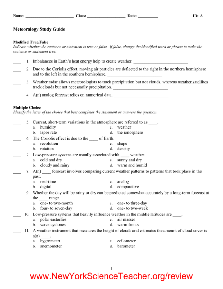
Name: ________________________ Class: ___________________ Date: __________ ID: A Meteorology Study Guide Modified True/False Indicate whether the sentence or statement is true or false. If false, change the identified word or phrase to make the sentence or statement true. ____ 1. Imbalances in Earth’s heat energy help to create weather. _________________________ ____ 2. Due to the Coriolis effect, moving air particles are deflected to the right in the northern hemisphere and to the left in the southern hemisphere. _________________________ ____ 3. Weather radar allows meteorologists to track precipitation but not clouds, whereas weather satellites track clouds but not necessarily precipitation. _________________________ ____ 4. A(n) analog forecast relies on numerical data. _________________________ Multiple Choice Identify the letter of the choice that best completes the statement or answers the question. ____ 5. Current, short-term variations in the atmosphere are referred to as ____. a. humidity c. weather b. lapse rate d. the ionosphere ____ 6. The Coriolis effect is due to the ____ of Earth. a. revolution c. shape b. rotation d. density ____ 7. Low-pressure systems are usually associated with ____ weather. a. cold and dry c. sunny and dry b. cloudy and rainy d. warm and humid ____ 8. A(n) ____ forecast involves comparing current weather patterns to patterns that took place in the past. a. real-time c. analog b. digital d. comparative ____ 9. Whether the day will be rainy or dry can be predicted somewhat accurately by a long-term forecast at the ____ range. a. one- to two-month c. one- to three-day b. four- to seven-day d. one- to two-week ____ 10. Low-pressure systems that heavily influence weather in the middle latitudes are ____. a. polar easterlies c. air masses b. wave cyclones d. warm fronts ____ 11. A weather instrument that measures the height of clouds and estimates the amount of cloud cover is a(n) ____. a. hygrometer c. ceilometer b. anemometer d. barometer 1 www.NewYorkScienceTeacher.org/review Name: ________________________ ID: A ____ 12. A balloon-borne package of sensors that gathers upper-level temperature, air pressure, and humidity ____ 13. ____ 14. ____ 15. ____ 16. ____ 17. ____ 18. is ____. a. a radiosonde c. a hygrometer b. a satellite d. Doppler radar The change in wave frequency of energy as it moves toward or away from an observer is the ____. a. Coriolis effect c. convergence effect b. Doppler effect d. radar effect Polar and tropical regions maintain fairly constant average temperatures because ____. a. the Sun always strikes these regions at the same angle b. air masses remain stationary near the poles and equator c. Earth radiates extra energy back into space d. the continual motion of air and water reallocates heat energy throughout Earth Differences in thermal energy can be detected with ____. a. ultraviolet imagery c. infrared imagery b. visible light d. sonar imagery A record of weather data for a particular site at a particular time is a(n) ____. a. station model c. isopleth model b. topographic map d. climate map Lines on a map that connect points of equal or constant values are ____. a. boundaries c. fronts b. isopleths d. station models The exchange of heat or moisture with the surface over which an air mass travels is known as ____. a. intertropical convergence c. occlusion b. air mass modification d. air mass exchange Matching Match each item with the correct source region below. a. warm and humid c. cool and humid b. cold and dry d. warm and dry ____ ____ ____ ____ 19. 20. 21. 22. Maritime polar (northern Pacific, Bering Sea) Maritime tropical (Gulf of Mexico) Continental tropical (southwestern desert of the United States) Continental polar (central Canada) Match each item with the correct statement below. a. trade winds c. prevailing westerlies b. polar easterlies d. jet streams ____ ____ ____ ____ 23. 24. 25. 26. Systems that lie between the poles and about 60° latitude in both hemispheres Narrow bands of fast, high-altitude westerly winds Winds occurring between 30° north and south latitude and the equator Winds that flow between 30° and 60° north and south latitude 2 www.NewYorkScienceTeacher.org/review Name: ________________________ ID: A Short Answer 27. What is the term used to describe long-term variations in weather for a particular area? 28. Would a six-month period with no rain in a place that usually gets plentiful rainfall be considered a weather phenomenon or a climate phenomenon? 29. Describe how winds help to overcome imbalances in the heating of Earth’s surface. 30. Describe how a cool, dry air mass can modify into a warm, moist air mass. 31. Compare and contrast the characteristics of a high pressure system and a low pressure system. 32. Explain why accurate weather data are important to meteorologists. 33. Why is weather forecasting more accurate today than it was 100 years ago? 34. Describe the importance of data from radiosondes. 35. Compare and contrast the information produced by Doppler radar and traditional weather radar. 36. What advantages does infrared imagery have over visible-light imagery? 37. Why are there accuracy problems with long-term forecasts? Compare and contrast each pair of related terms or phrases. 38. weather, climate 39. trade winds, prevailing westerlies 40. air mass, front 41. thermometer, barometer 42. anemometer, hygrometer 43. digital forecast, analog forecast 44. Explain how air masses form, and how they help redistribute energy on Earth’s surface. 45. Describe the formation and location of jet streams. 46. Identify the four types of fronts and the weather conditions associated with each one. 47. Compare and contrast a continental polar air mass and a maritime tropical air mass. 48. What problems are associated with long-term weather forecasts? 49. You examine two weather maps of your area for two different days. One map shows isobars that are closely spaced; the other shows isobars that are far apart. Predict the difference in weather conditions for those days. 50. How would Earth’s wind systems be different if the whole planet were heated equally? 3 www.NewYorkScienceTeacher.org/review Name: ________________________ ID: A 51. Your town is experiencing a drought in which the weather has been hot and dry for weeks. Infer which type of pressure system is stalled over the area. Explain your answer. 52. There are six weather instruments collecting weather data in a city you are about to visit: an anemometer, a barometer, a ceilometer, a hygrometer, a radiosonde, and a thermometer. You need information that will allow you to dress properly when you arrive. You can have the data from just three of the instruments. Which ones would you pick and why? 53. Explain how infrared imagery has the potential to save lives. A meteorology class has set up a small weather station outside of school. It has a few simple instruments: a thermometer, a barometer, a rain gauge to measure rainfall, and a hygrometer. The students took measurements with the instruments once a day for a week. They then filled in the chart below. The barometer broke, so they were not able to finish collecting air-pressure data. Use the chart and what you know about weather systems and weather forecasting to answer the following questions. Mon Tue Wed Thurs Fri Sat Sun 23.3 22.2 22.2 15.6 16.7 16.7 17.8 0 0 3.31 0 0 0 0 Relative humidity 40% 60% 100% 80% 60% 50% 40% Air pressure (mb) 1000 998 — — — — — Average temperature (C) Rainfall (cm) 54. A cold front passed through the students’ city during the week. Showers occur at fronts. On which day did the front pass through? 55. What evidence does the data provide of the arrival of the front? Give two examples. 56. The students did not record cloud cover data. If they had, what would their observations have been as the front arrived? 57. Low-pressure systems are associated with clouds and precipitation. If the students’ barometer had continued to work, would the air pressure reading for Wednesday have been higher or lower than the one for Tuesday, when the weather was clearer? 58. Given the relative humidity on Thursday, would you expect clear or cloudy skies? 59. Would the students be able to make an accurate digital forecast based on the data they have collected? Explain your answer. 60. Use the data in the chart to make an analog forecast of the weather for the Monday following the last day in the chart. Explain your answer. 4 www.NewYorkScienceTeacher.org/review Name: ________________________ ID: A Problem 61. Fill in the chart below with the correct type of front. Use the following terms: cold front, occluded front, stationary front, warm front. Movement of air masses An advancing warm air mass displaces a cold air mass and glides over the top of it. Two air masses with similar temperatures and pressures meet, and neither advances into the other's territory. A cold, dense air mass displaces a warm air mass and forces the warm air to rise steeply. A warm air mass is squeezed upward between two cold air masses. Type of front a. b. c. d. 62. Fill in the chart below with the names of the correct weather instruments. Use the following terms: anemometer, barometer, ceilometer, hygrometer, radiosonde, thermometer. What weather instrument does Weather instrument name Measures relative humidity a. Measures temperature b. Measures height of cloud layers and estimates percentage of sky covered by clouds. c. Measures wind speed d. Measures air pressure e. 5 www.NewYorkScienceTeacher.org/review Name: ________________________ ID: A Answer the following questions based on the weather chart below. 63. In which city is it raining? 64. Describe the weather at City A. 65. Describe the weather at City C. 6 www.NewYorkScienceTeacher.org/review ID: A Meteorology Study Guide Answer Section MODIFIED TRUE/FALSE 1. 2. 3. 4. T T T F, digital MULTIPLE CHOICE 5. 6. 7. 8. 9. 10. 11. 12. 13. 14. 15. 16. 17. 18. C B B C C B C A B D C A B B MATCHING 19. 20. 21. 22. C A D B 23. 24. 25. 26. B D A C SHORT ANSWER 27. climate 28. weather 1 www.NewYorkScienceTeacher.org/review ID: A 29. Winds bring warm tropical air to colder areas and bring cooler polar air to warmer area, helping to 30. 31. 32. 33. 34. 35. 36. 37. 38. 39. 40. 41. 42. 43. overcome heat imbalances. A cool, dry air mass could move over a warm, moist part of Earth’s surface, such as a warm body of water. The air mass would then take on characteristics of the new surface beneath it, becoming warmer and moister. Winds rotate around the centers of both systems. In a high-pressure system, air sinks at the center and spreads outward at the surface. Winds move in a clockwise direction in the northern hemisphere. In a low-pressure system, air moves inward toward the center and rises. Winds move in a counterclockwise direction in the northern hemisphere. Meteorologists rely on accurate weather data to make reliable weather forecasts so that people can be informed of significant changes in weather conditions and prepare for them. Meteorologists have technology that was unavailable 100 years ago. Satellites, computers, and radar are examples of technology that allow meteorologists to collect more precise data. Radiosondes allow meteorologists to create a profile of the temperature, air pressure, humidity, and wind speed/direction of a particular part of the troposphere. These data are important factors in making accurate forecasts. Both allow meteorologists to gather data about areas of precipitation. Traditional weather radar allows meteorologists to track the location of precipitation, whereas Doppler radar allows meteorologists to estimate wind speeds associated with areas of precipitation, including those in thunderstorms and tornadoes. Visible-light imagery doesn’t work in darkness, while infrared imagery does. Unlike visible-light imagery, infrared imagery allows meteorologists to detect differences in thermal energy that can pinpoint cloud location and type, including large cumulonimbus clouds that can mean severe weather. Infrared imagery can also map surface temperatures, which visible-light imagery cannot detect. Long-term forecasting involves predicting the interactions of numerous surface and upper-level atmospheric factors. Over time, these factors interact to create progressively more complicated scenarios. Both refer to the conditions of the atmosphere. However, weather refers to current atmospheric conditions, while climate refers to long-term weather patterns for an area. Both are global wind systems. The trade winds are easterlies that occur between 30° and the equator in both the northern and southern hemispheres. The prevailing westerlies are westerlies that flow between 30° and 60° latitude north and south of the equator. The two systems have opposite circulation patterns. Both involve the movement of weather systems. However, an air mass is a large body of air that takes on the characteristics of the area over which it forms, while a front is a narrow region separating two air masses of different densities. Both are weather instruments. A thermometer measures temperature, while a barometer measures air pressure. Both are weather instruments. An anemometer measures wind speed and direction, while a hygrometer measures relative humidity. Both are methods of weather forecasting. The digital forecast relies on numerical data collected by many weather instruments and analyzed by computers, while the analog forecast relies on comparing past and current weather patterns. 2 www.NewYorkScienceTeacher.org/review ID: A 44. A large mass of air takes on the temperature and humidity characteristics of the land or water under 45. 46. 47. 48. 49. 50. 51. 52. 53. 54. 55. 56. 57. 58. 59. 60. it. An air mass redistributes energy by moving from place to place, transferring energy from one area to another. Jet streams are narrow bands of fast, high-altitude westerly winds that form as a result of great differences in temperature and pressure between the boundaries of the major wind systems. They form in the midlatitudes between the polar easterlies and the prevailing westerlies, and between the prevailing westerlies and the trade winds. Cold fronts are associated with clouds, showers, and thunderstorms. Warm fronts are characterized by extensive cloudiness and light precipitation. Stationary fronts usually are associated with light precipitation and light cloud cover, and, less frequently, weather similar to that of warm fronts. Occluded fronts are characterized by weather similar to warm fronts and cold fronts. Both are air masses that have taken on the characteristics of the area over which they formed. A continental polar air mass is cold and dry, having formed over polar land. A maritime tropical air mass is warm and humid, having formed over tropical oceans. Forecasts become less reliable when they attempt to predict long-term changes in weather. This is because many factors affect the weather and, over time, all these factors interact to create progressively more complicated scenarios that are difficult to predict. Isobars that are closely spaced indicate a large pressure difference over a small area and strong winds. Isobars that are far apart indicate a small pressure difference over an area and light winds. Wind systems exist because differences in temperature and air pressure create moving air. With equal temperature and pressure all over the surface, there would be no global wind systems. Most likely, there is a high-pressure system over the area. High-pressure systems are characterized by sinking air, which works against the formation of clouds and precipitation. Possible response: Anemometer, thermometer, hygrometer, or ceilometer; these instruments would give you data on wind speed, temperature, relative humidity, or cloud cover, which would be useful in choosing clothing. The data from the barometer (air pressure) and radiosonde (high-level data) would be much less useful. It allows meteorologists to determine the temperature of a cloud. From this, they can infer the cloud type and estimate its height. Because the strength of a thunderstorm is related to its height, infrared imagery gives data that can predict a storm’s potential severity. When people have advance warning of a severe storm, they can take precautions. Wednesday On Wednesday, there was rainfall and the associated increase in humidity. Clouds form at cold fronts, so clouds would have been visible as the front arrived. The pressure would have been lower on Wednesday, when the front was passing through with clouds and precipitation. The high relative humidity indicates cloudy skies. They would be able to make a digital forecast if they knew how to express mathematically the relationships between the atmospheric variables they have collected. However, the forecast probably would not be highly accurate because their data are not very dense. Possible answer: The temperature might be 18° or 19°C, since the trend seems to be rising temperatures. The relative humidity has been falling for the past few days, so it is likely that Monday will have clear skies. Without air pressure data, however, it is difficult to make a guess as to whether a front is approaching. 3 www.NewYorkScienceTeacher.org/review ID: A PROBLEM 61. a. warm front 62. 63. 64. 65. b. stationary front c. cold front d. occluded front a. hygrometer b. thermometer c. ceilometer d. anemometer e. barometer City B It is clear, 81° Fahrenheit, with light winds blowing at 1–3 mph. Students do not have to know wind direction. It is partly cloudy with about half the sky covered by clouds, 87° Fahrenheit, with light winds blowing at 1–3 mph. Students do not have to know wind direction. 4 www.NewYorkScienceTeacher.org/review
