Locating the Epicenter Lab
advertisement
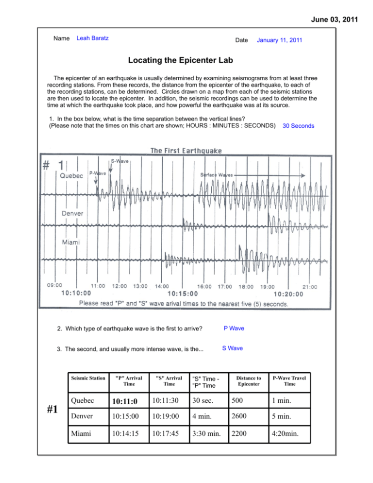
June 03, 2011 Name Leah Baratz Date January 11, 2011 Locating the Epicenter Lab The epicenter of an earthquake is usually determined by examining seismograms from at least three recording stations. From these records, the distance from the epicenter of the earthquake, to each of the recording stations, can be determined. Circles drawn on a map from each of the seismic stations are then used to locate the epicenter. In addition, the seismic recordings can be used to determine the time at which the earthquake took place, and how powerful the earthquake was at its source. 1. In the box below, what is the time separation between the vertical lines? (Please note that the times on this chart are shown; HOURS : MINUTES : SECONDS) 2. Which type of earthquake wave is the first to arrive? P Wave 3. The second, and usually more intense wave, is the... S Wave Seismic Station #1 "P" Arrival Time "S" Arrival Time "S" Time "P" Time Distance to Epicenter 30 Seconds P-Wave Travel Time Quebec 10:11:0 10:11:30 30 sec. 500 1 min. Denver 10:15:00 10:19:00 4 min. 2600 5 min. Miami 10:14:15 10:17:45 3:30 min. 2200 4:20min. June 03, 2011 Leah Baratz The data you entered on the last page can be used to locate the epicenter and to find the exact time at which this earthquake occurred. Here's how. The diagram to the right shows that with only a single station, we can tell how far away the epicenter is, but we are not able to find the direction to the epicenter. A second station allows us to make another circle and determine two possible locations. The third circle should locate the exact position of the epicenter. Three circles should intersect at a single point: the epicenter. 4. Why are more that two seismic stations needed to locate the epicenter of an earthquake? It determines two possible locations. To locate the epicenter of the earthquake shown on page 1, you will need a drawing compass, a pencil (we will use smart notebook), and a copy of the earthquake travel time graph (page 7). Obtain these materials before you continue in this lab. Use the map scale on page 5 and then click on the compass button. Stretch out the drawing compass to the proper distance from each recording station. (As read from the table you completed on page 1) Around the first station, draw a circle at the proper distance. Now click on the circle and right click to lock this circle into place. HINT : You may want to use one color for the circles used to locate one epicenter. Repeat the steps above for two more recording stations. Once you have three circles on your map look to see where they intersect. At that location drag the small triangle labeled E1. Now again right click and lock that triangle into place. Congratulations you are done locating the epicenter for the first earthquake! June 03, 2011 Leah Baratz When you have drawn the first circle and the needed portions of the second and third circles, the three circles should intersect at one point, or they should make a very small triangle. That's the location of the epicenter. The actual time at which the earthquake took place at the focus (and at the epicenter) is called the origin time. Once the distance from the epicenter to any recording station is known, it is possible to find the origin time of the earthquake. 5. How long does it take a P-wave to travel 4000 km? (Hint: look at the Earthquake Travel Time Graph) 7 minutes 6. If the P-waves from that earthquake 4000km away arrived at our station at exactly 12:00:00 (noon), when did they start their journey? (That is, when was the earthquake origin time?) 8 min. Use this technique to determine the origin time of earthquake #1 recorded on the front page. (You can check yourself by doing the same subtraction with the S-wave or with a different station.) 7. Time that the P-wave arrived at Quebec: Epicenter distance from Quebec: 500 miles 10:11;30 Travel time for P-wave 1 minute 9:11:00 Origin time. (Arrival Time - Travel Time) The table below shows you data from another earthquake. Complete this table, then use the data to draw circles in order to locate the epicenter of this event on the same map that you used for the first earthquake. (Hint - use a different color for the circles for Earthquake #2) On the map on page 5, drag and lock the triangle labeled E2 to label the epicenter of this earthquake. Seismic Station "P" Arrival Time "S" Arrival Time "S" Time "P" Time Distance to Epicenter P-Wave Travel Time Origin Time Seattle 13:08:10 13:10:50 2:40 1600 3:20 9:18:50 Denver 13:07:35 13:09:50 2:15 1000 2:40 10:33:25 Anchorage 13:11:50 13:17:15 5:45 3000 5:40 7:11:45 8. How can we tell the distance to an earthquake from the records of a single seismic recording location? The three distances/locations of the seismic readings can overlap into a region. June 03, 2011 Leah Baratz The diagram below shows an earthquake as recorded at five recording stations. Use this information to both locate the epicenter on the map on page 5, and to determine the origin time of this event. Drag and lock the triangle labeled E3. Please draw all 5 circles, even thought three should be enough to show the location of the epicenter. Seismic Station "P" Arrival "S" Arrival "S" - "P" Time Time Time Distance to Epicenter P-Wave Travel Time Origin TIme New York 15:45:00 15:52:00 0:7:00 5400 9 min. 6:45 Mexico City 15:46:00 15:53:30 0:7:30 6000 9:20 min. 6:26 Denver 15:43:00 15:48:45 0:5:15 4000 7 min. 8:43 Quebec 15:44:20 15:50:40 0:5:20 3800 7 min. 8:44:20 San Francisco 15:42:10 15:47:00 0:5:50 4400 7 min 40 sec 8:02:10 9. What is your best estimate of the origin time of the third earthquake (#3 above)? 7:20 _____________ June 03, 2011 Leah Baratz E3 E2 E1 June 03, 2011 Leah Baratz 10. How many stations are required to locate an epicenter? 3 11. In what three ways are P-waves different from S-waves? 1- Faster 2- Travel through any material 3- Less damage on the surface 12. To locate an epicenter, subtract the S-Wave arrival time. Then, use the travel time chart in the rate find the 2 arrival time from the P-Wave seismogram at which that time separation applies. Do the same for at least more seismic stations. Around each seismic recording station, draw a at the proper distance. Where the three circles meet To find the origin time, subtract the p wave travel time 13. Define latitude: 14. Define longitude: p wave arrival time circle is the epicenter. for any P or S-wave from the of that wave. That's when the earthquake occurred at the epicenter. imaginary horizontal lines that circle the globe (measures east and west of the prime meridian) imaginary vertical lines that circle the globe (measures north and south of the equator) 15. From the map on page 5, list the terrestrial coordinates the three epicenters that you located in this lab. (Be sure to label each with both the angle and the direction: like 45N, or 127E) #1 latitude longitude 40 N 80 W #2 latitude longitude 55 N 120 W #3 latitude longitude 40 N 105 W 16. We are not able to locate the epicenter of an earthquake with seismic records from just one recording station. What can we figure out about the earthquake at its source from a single seismic station? (There are at least four answers to this question. You must list two for full credit.) The earthquake was too far The earthquake was too small June 03, 2011

