improving flight safety with satellite data
advertisement
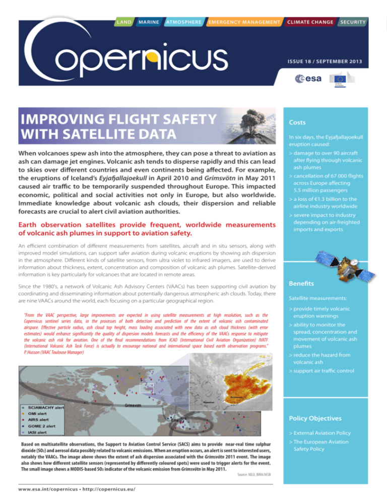
LAND MARINE ATMOSPHERE EMERGENCY MANAGEMENT CLIMATE CHANGE SECURITY ISSUE 18 / SEPTEMBER 2013 IMPROVING FLIGHT SAFETY WITH SATELLITE DATA Costs In six days, the Eyjafjallajoekull eruption caused: When volcanoes spew ash into the atmosphere, they can pose a threat to aviation as ash can damage jet engines. Volcanic ash tends to disperse rapidly and this can lead to skies over different countries and even continents being affected. For example, the eruptions of Iceland’s Eyjafjallajoekull in April 2010 and Grímsvötn in May 2011 caused air traffic to be temporarily suspended throughout Europe. This impacted economic, political and social activities not only in Europe, but also worldwide. Immediate knowledge about volcanic ash clouds, their dispersion and reliable forecasts are crucial to alert civil aviation authorities. Earth observation satellites provide frequent, worldwide measurements of volcanic ash plumes in support to aviation safety. > damage to over 90 aircraft after flying through volcanic ash plumes > cancellation of 67 000 flights across Europe affecting 5.5 million passengers > a loss of €1.3 billion to the airline industry worldwide > severe impact to industry depending on air-freighted imports and exports An efficient combination of different measurements from satellites, aircraft and in situ sensors, along with improved model simulations, can support safer aviation during volcanic eruptions by showing ash dispersion in the atmosphere. Different kinds of satellite sensors, from ultra violet to infrared imagers, are used to derive information about thickness, extent, concentration and composition of volcanic ash plumes. Satellite-derived information is key particularly for volcanoes that are located in remote areas. Since the 1980's, a network of Volcanic Ash Advisory Centers (VAACs) has been supporting civil aviation by coordinating and disseminating information about potentially dangerous atmospheric ash clouds. Today, there are nine VAACs around the world, each focusing on a particular geographical region. "From the VAAC perspective, large improvements are expected in using satellite measurements at high resolution, such as the Copernicus sentinel series data, in the processes of both detection and prediction of the extent of volcanic ash contaminated airspace. Effective particle radius, ash cloud top height, mass loading associated with new data as ash cloud thickness (with error estimates) would enhance significantly the quality of dispersion models forecasts and the efficiency of the VAACs response to mitigate the volcanic ash risk for aviation. One of the final recommendations from ICAO (International Civil Aviation Organization) IVATF (International Volcanic Ash Task Force) is actually to encourage national and international space based earth observation programs." P. Husson (VAAC Toulouse Manager) Benefits Satellite measurements: > provide timely volcanic eruption warnings > ability to monitor the spread, concentration and movement of volcanic ash plumes > reduce the hazard from volcanic ash > support air traffic control Policy Objectives > External Aviation Policy Based on multisatellite observations, the Support to Aviation Control Service (SACS) aims to provide near-real time sulphur dioxide (SO2) and aerosol data possibly related to volcanic emissions. When an eruption occurs, an alert is sent to interested users, notably the VAACs. The image above shows the extent of ash dispersion associated with the Grimsvötn 2011 event. The image also shows how different satellite sensors (represented by differently coloured spots) were used to trigger alerts for the event. The small image shows a MODIS-based SO2 indicator of the volcanic emission from Grimsvötn in May 2011. Source: NILU, BIRA/IASB www.esa.int/copernicus • http://copernicus.eu/ > The European Aviation Safety Policy ISSUE 18 / SEPTEMBER 2013 COPERNICUS ACTIVITIES Copernicus services Looking to the future, the Copernicus Atmosphere Monitoring Service demonstrates the capability of using satellite data to develop products in support of aviation safety. Example products: > Monitoring and simulation of sulphur dioxide expansion in plumes of volcanic gas following eruptions > Monitoring and forecasting of aerosols and ash plumes following eruptions Sentinel contribution Next steps Sentinel-2, -3, -4 , -5 and 5P will provide more efficient and guaranteed support for global ash cloud monitoring: > Improve space-based volcano monitoring products (e.g. SO2 and ash characterisation parameters) > Sentinel-2 provides multi-spectral observations at high spatial resolution > Enhance the response capacity of European Volcano Observatories and include satellite data in operations > Sentinel-3 provides consistent multispectral observations at low spatial resolution > Sentinel-4 provides high-frequency information on SO2 and aerosol over Europe > Sentinel-5 and Sentinel-5P provide UV monitoring capabilities to derive ash and SO2 > Improve dispersion and forecasting models, e.g. especially for correlation between thermal and gas emission precursors and volcanic eruption activities > Integrate spaceborne with ground-based and airborne measurements Sentinel-4 The Copernicus geostationary atmospheric mission Geostationary satellites, providing data every 15 minutes, are essential in the first hours of a volcanic eruption. This is when there is the greatest danger to aviation and when there is no or little other information available. When Grimsvötn erupted, the SEVIRI instrument, on the geostationary Meteosat Second Generation satellite, provided the first images of the event. The Sentinel-4 mission, which will be carried on the Meteosat Third Generation (MTG) satellites, covers the need for continuous monitoring of atmospheric chemistry at high temporal resolution from the geostationary orbit. The map shows a large SO2 plume (measured in Dobson Units) from the eruption of Grimsvötn volcano, which was detected by GOME-2 instrument on MetOp on 22 May 2011. First estimates of the eruption height ranged from 12 to 17 km, which is above the typical aircraft cruising altitude. Source: DLR www.esa.int/copernicus • http://copernicus.eu/ By providing data on SO2 and aerosols over Europe, the mission will help to improve the monitoring and early detection of ash plumes.
