Chapter 6 - Idaho County
advertisement
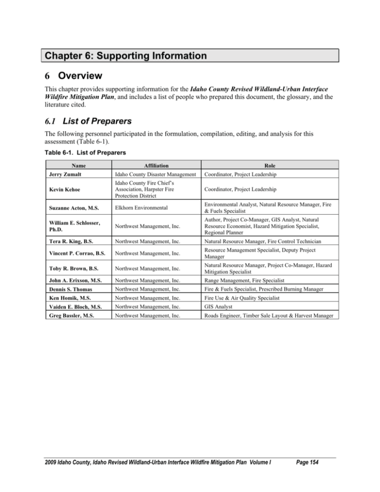
Chapter 6: Supporting Information 6 Overview This chapter provides supporting information for the Idaho County Revised Wildland-Urban Interface Wildfire Mitigation Plan, and includes a list of people who prepared this document, the glossary, and the literature cited. 6.1 List of Preparers The following personnel participated in the formulation, compilation, editing, and analysis for this assessment (Table 6-1). Table 6-1. List of Preparers Name Affiliation Role Jerry Zumalt Idaho County Disaster Management Coordinator, Project Leadership Kevin Kehoe Idaho County Fire Chief’s Association, Harpster Fire Protection District Coordinator, Project Leadership Suzanne Acton, M.S. Elkhorn Environmental Environmental Analyst, Natural Resource Manager, Fire & Fuels Specialist William E. Schlosser, Ph.D. Northwest Management, Inc. Author, Project Co-Manager, GIS Analyst, Natural Resource Economist, Hazard Mitigation Specialist, Regional Planner Tera R. King, B.S. Northwest Management, Inc. Natural Resource Manager, Fire Control Technician Vincent P. Corrao, B.S. Northwest Management, Inc. Resource Management Specialist, Deputy Project Manager Toby R. Brown, B.S. Northwest Management, Inc. Natural Resource Manager, Project Co-Manager, Hazard Mitigation Specialist John A. Erixson, M.S. Northwest Management, Inc. Range Management, Fire Specialist Dennis S. Thomas Northwest Management, Inc. Fire & Fuels Specialist, Prescribed Burning Manager Ken Homik, M.S. Northwest Management, Inc. Fire Use & Air Quality Specialist Vaiden E. Bloch, M.S. Northwest Management, Inc. GIS Analyst Greg Bassler, M.S. Northwest Management, Inc. Roads Engineer, Timber Sale Layout & Harvest Manager 2009 Idaho County, Idaho Revised Wildland-Urban Interface Wildfire Mitigation Plan Volume I Page 154 6.2 Acronyms and Glossary BLM CAR - BLM Communities-at-Risk (Community Assistance Funding) BLM RFA - BLM Rural Fire Assistance BIA CA - Bureau of Indian Affairs Community Assistance BIA RFA - BIA Rural Fire Assistance IDL/FS VFA - Volunteer Fire Assistance IDL/FS CFP - Community Fire Protection (formerly Steven's funds) IDL/FS SFA - State Fire Adjacent (Western States WUI Grant Program) IDL/BLM - Partnership Funds FS EA - US Forest Service Economic Assistance Program (primarily for woody biomass) FEMA AFG - Assistance to Firefighters Grant IFCA FFLP - Idaho Fire Chiefs Association Fire Fighter's License Plate Fund Anadromous - Fish species that hatch in fresh water, migrate to the ocean, mature there, and return to fresh water to reproduce (Salmon & Steelhead). Appropriate Management Response - Specific actions taken in response to a wildland fire to implement protection and fire use objectives. Biological Assessment - Information document prepared by or under the direction of the Federal agency in compliance with U.S. Fish and Wildlife standards. The document analyzes potential effects of the proposed action on listed and proposed threatened and endangered species and proposed critical habitat that may be present in the action area. Backfiring - When attack is indirect, intentionally setting fire to fuels inside the control line to contain a rapidly spreading fire. Backfiring provides a wide defense perimeter, and may be further employed to change the force of the convection column. Blackline - Denotes a condition where the fire line has been established by removal of vegetation by burning. Burning Out - When attack is direct, intentionally setting fire to fuels inside the control line to strengthen the line. Burning out is usually done by the crew boss as a part of line construction; the control line is considered incomplete unless there is no fuel between the fire and the line. Canyon Grassland - Ecological community in which the prevailing or characteristic plants are grasses and similar plants extending from the canyon rim to the river’s edge. Confine - Confinement is the strategy employed in appropriate management responses where a fire perimeter is managed by a combination of direct and indirect actions and use of natural topographic features, fuel, and weather factors. Contingency Plans: Provides for the timely recognition of approaching critical fire situations and for timely decisions establishing priorities to resolve those situations. Control Line - An inclusive term for all constructed or natural fire barriers and treated fire edge used to control a fire. 2009 Idaho County, Idaho Revised Wildland-Urban Interface Wildfire Mitigation Plan Volume I Page 155 Crew - An organized group of firefighters under the leadership of a crew boss or other designated official. Crown Fire - A fire that advances from top to top of trees or shrubs more or less independently of the surface fire. Sometimes crown fires are classed as either running or dependent, to distinguish the degree of independence from the surface fire. Disturbance - An event that affects the successional development of a plant community (examples: fire, insects, wind throw, timber harvest). Disturbed Grassland - Grassland dominated by noxious weeds and other exotic species. Greater than 30% exotic cover. Diversity - The relative distribution and abundance of different plant and animal communities and species within an area. Drainage Order - Systematic ordering of the network of stream branches, (e.g., each non-branching channel segment is designated a first order stream, streams which only receive first order segments are termed second order streams). Duff - The partially decomposed organic material of the forest floor beneath the litter of freshly fallen twigs, needles, and leaves. Ecosystem - An interacting system of interdependent organisms and the physical set of conditions upon which they are dependent and by which they are influenced. Ecosystem Stability - The ability of the ecosystem to maintain or return to its steady state after an external interference. Ecotone - The area influenced by the transition between plant communities or between successional stages or vegetative conditions within a plant community. Energy Release Component - The Energy Release Component is defined as the potential available energy per square foot of flaming fire at the head of the fire and is expressed in units of BTUs per square foot. Equivalent Clear-cut Area (ECA) - An indicator of watershed condition, which is calculated from the total amount of crown removal that has occurred from harvesting, road building, and other activities based on the current state of vegetative recovery. Exotic Plant Species - Plant species that are introduced and not native to the area. Fire Adapted Ecosystem - An arrangement of populations that have made long-term genetic changes in response to the presence of fire in the environment. Fire Behavior - The manner in which a fire reacts to the influences of fuel, weather, and topography. Fire Behavior Forecast - Fire behavior predictions prepared for each shift by a fire behavior analysis to meet planning needs of fire overhead organization. The forecast interprets fire calculations made, describes expected fire behavior by areas of the fire, with special emphasis on personnel safety, and identifies hazards due to fire for ground and aircraft activities. Fire Behavior Prediction Model - A set of mathematical equations that can be used to predict certain aspects of fire behavior when provided with an assessment of fuel and environmental conditions. Fire Danger - A general term used to express an assessment of fixed and variable factors such as fire risk, fuels, weather, and topography, which influence whether fires will start, spread, and do damage; also the degree of control difficulty to be expected. 2009 Idaho County, Idaho Revised Wildland-Urban Interface Wildfire Mitigation Plan Volume I Page 156 Fire Ecology - The scientific study of fire’s effects on the environment, the interrelationships of plants, and the animals that live in such habitats. Fire Exclusion - The disruption of a characteristic pattern of fire intensity and occurrence (primarily through fire suppression). Fire Intensity Level - The rate of heat release (BTU/second) per unit of fire front. Four foot flame lengths or less are generally associated with low intensity burns and four to six foot flame lengths generally correspond to “moderate” intensity fire effects. High intensity flame lengths are usually greater than eight feet and pose multiple control problems. Fire Prone Landscapes – The expression of an area’s propensity to burn in a wildfire based on common denominators such as plant cover type, canopy closure, aspect, slope, road density, stream density, wind patterns, position on the hillside, and other factors. Fireline - A loose term for any cleared strip used in control of a fire. That portion of a control line from which flammable materials have been removed by scraping or digging down to the mineral soil. Fire Management - The integration of fire protection, prescribed fire and fire ecology into land use planning, administration, decision making, and other land management activities. Fire Management Plan (FMP) - A strategic plan that defines a program to manage wildland and prescribed fires and documents the fire management program in the approved land use plan. This plan is supplemented by operational procedures such as preparedness, preplanned dispatch, burn plans, and prevention. The fire implementation schedule that documents the fire management program in the approved forest plan alternative. Fire Management Unit (FMU) - Any land management area definable by objectives, topographic features, access, values-to-be-protected, political boundaries, fuel types, or major fire regimes, etc., that set it apart from management characteristics of an adjacent unit. FMU’s are delineated in FMP’s. These units may have dominant management objectives and preselected strategies assigned to accomplish these objectives. Fire Occurrence - The number of wildland fires started in a given area over a given period. (Usually expressed as number per million acres.) Fire Prevention - An active program in conjunction with other agencies to protect human life, prevent modification of the ecosystem by human-caused wildfires, and prevent damage to cultural resources or physical facilities. Activities directed at reducing fire occurrence, including public education, law enforcement, personal contact, and reduction of fire risks and hazards. Fire Regime - The fire pattern across the landscape, characterized by occurrence interval and relative intensity. Fire regimes result from a unique combination of climate and vegetation. Fire regimes exist on a continuum from short-interval, low-intensity (stand maintenance) fires to long-interval, high-intensity (stand replacement) fires. Fire Retardant - Any substance that by chemical or physical action reduces flammability of combustibles. Fire Return Interval - The number of years between two successive fires documented in a designated area. Fire Risk - The potential that a wildfire will start and spread rapidly as determined by the presence and activities of causative agents. Fire Severity - The effects of fire on resources displayed in terms of benefit or loss. Foothills Grassland - Grass and forb co-dominated dry meadows and ridges. Principle habitat type series: bluebunch wheatgrass and Idaho fescue. 2009 Idaho County, Idaho Revised Wildland-Urban Interface Wildfire Mitigation Plan Volume I Page 157 Fuel - The materials that are burned in a fire: duff, litter, grass, dead branch wood, snags, logs, etc. Fuel Break - A natural or manmade change in fuel characteristics that affects fire behavior so that fires burning into them can be more readily controlled. Fuel Loading - Amount of dead fuel present on a particular site at a given time; the percentage of it available for combustion changes with the season. Fuel Model - Characterization of the different types of wildland fuels (trees, brush, grass, etc.) and their arrangement, used to predict fire behavior. Fuel Type - An identifiable association of fuel elements of distinctive species; form, size, arrangement, or other characteristics, that will cause a predictable rate of fire spread or difficulty of control, under specified weather conditions. Fuels Management - Manipulation or reduction of fuels to meet protection and management objectives, while preserving and enhancing environmental quality. Gap Analysis Program (GAP) - Regional assessments of the conservation status of native vertebrate species and natural land cover types and to facilitate the application of this information to land management activities. This is accomplished through the following five objectives: 1. Map the land cover of the United States. 2. Map predicted distributions of vertebrate species for the U.S. 3. Document the representation of vertebrate species and land cover types in areas managed for the long-term maintenance of biodiversity. 4. Provide this information to the public and those entities charged with land use research, policy, planning, and management. 5. Build institutional cooperation in the application of this information to state and regional management activities. Habitat - A place that provides seasonal or year-round food, water, shelter, and other environmental conditions for an organism, community, or population of plants or animals. Heavy Fuels - Fuels of a large diameter, such as snags, logs, and large limb wood, which ignite and are consumed more slowly than flash fuels. Hydrologic Unit Code - A coding system developed by the U. S. Geological Service to identify geographic boundaries of watersheds of various sizes. Hydrophobic - Resistance to wetting exhibited by several soils, also called water repellency. The phenomena may occur naturally or may be fire-induced. It may be determined by water drop penetration time, equilibrium liquid-contact angles, solid-air surface tension indices, or the characterization of dynamic wetting angles during infiltration. Human-Caused Fires - Refers to fires ignited accidentally (from campfires or smoking) and by arsonists; does not include fires ignited intentionally by fire management personnel to fulfill approved, documented management objectives (prescribed fires). Intensity - The rate of heat energy released during combustion per unit length of fire edge. Inversion - Atmospheric condition in which temperature increases with altitude. Ladder Fuels - Fuels that provide vertical continuity between strata, thereby allowing fire to carry from surface fuels into the crowns of trees or shrubs with relative ease. They help initiate and assure the continuation of crowning. 2009 Idaho County, Idaho Revised Wildland-Urban Interface Wildfire Mitigation Plan Volume I Page 158 Landsat Imagery - Land remote sensing, the collection of data, which can be processed into imagery of surface features of the Earth from an unclassified satellite or satellites. Landscape - All the natural features such as grasslands, hills, forest, and water, which distinguish one part of the earth’s surface from another part; usually that portion of land which the eye can comprehend in a single view, including all its natural characteristics. Lethal - Relating to or causing death; extremely harmful. Lethal Fires - A descriptor of fire response and effect in forested ecosystems of high-severity or severe fire that burns through the overstory and understory. These fires typically consume large woody surface fuels and may consume the entire duff layer, essentially destroying the stand. Litter - The top layer of the forest floor composed of loose debris, including dead sticks, branches, twigs, and recently fallen leaves or needles, little altered in structure by decomposition. Maximum Manageable Area - The boundary beyond which fire spread is completely unacceptable. Metavolcanic - Volcanic rock that has undergone changes due to pressure and temperature. Minimum Impact Suppression Strategy (MIST) - “Light on the Land.” Use of minimum amount of forces necessary to effectively achieve the fire management protection objectives consistent with land and resource management objectives. It implies a greater sensitivity to the impacts of suppression tactics and their long-term effects when determining how to implement an appropriate suppression response. Mitigation - Actions to avoid, minimize, reduce, eliminate, replace, or rectify the impact of a management practice. Monitoring Team - Two or more individuals sent to a fire to observe, measure, and report its behavior, its effect on resources, and its adherence to or deviation from its prescription. National Environmental Policy Act (NEPA) - This act declared a national policy to encourage productive and enjoyable harmony between humans and their environment; to promote efforts which will prevent or eliminate damage to the environment and biosphere and will stimulate the health and welfare of humankind; to enrich the understanding of important ecological systems and natural resources; and to establish a Council on Environmental Quality. National Fire Management Analysis System (NFMAS) - The fire management analysis process, which provides input to forest planning and forest and regional fire program development and budgeting. Native - Indigenous; living naturally within a given area. Natural Ignition - A wildland fire ignited by a natural event such as lightning or volcanoes. Noncommercial Thinning - Thinning by fire or mechanical methods of pre-commercial or commercial size timber, without recovering value, to meet MFP standards relating to the protection/enhancement of adjacent forest or other resource values. Notice of Availability - A notice of Availability published in the Federal Register stating that an EIS has been prepared and is available for review and comment (for draft) and identifying where copies are available. Notice of Intent - A Notice of Intent published in the Federal Register stating that an EIS will be prepared and considered. This notice will describe the proposed action and possible alternatives, the proposed scoping process, and the name and address of whom to contact concerning questions about the proposed action and EIS. Noxious Weeds - Rapidly spreading plants that have been designated “noxious” by law, which can cause a variety of major ecological impacts to both agricultural and wild lands. 2009 Idaho County, Idaho Revised Wildland-Urban Interface Wildfire Mitigation Plan Volume I Page 159 Planned Ignition - A wildland fire ignited by management actions to meet specific objectives. Prescribed Fire - Any fire ignited by management actions to meet specific objectives. A written, approved prescribed fire plan must exist, and NEPA requirements must be met, prior to ignition. Prescription - A set of measurable criteria that guides the selection of appropriate management strategies and actions. Prescription criteria may include safety, economic, public health, environmental, geographic, administrative, social, or legal considerations. Programmatic Biological Assessment - Assesses the effects of the fire management programs on federally listed species, not the individual projects that are implemented under these programs. A determination of effect on listed species is made for the programs, which is a valid assessment of the potential effects of the projects completed under these programs, if the projects are consistent with the design criteria and monitoring and reporting requirement contained in the project description and summaries. Reburn - Subsequent burning of an area in which fire has previously burned but has left flammable fuel that ignites when burning conditions are more favorable. Riparian Habitat Conservation Areas (RHCA) - Portions of watersheds where riparian-dependent resources receive primary emphasis, and management activities are subject to specific standards and guidelines. RHCAs include traditional riparian corridors, wetlands, intermittent headwater streams, and other areas where proper ecological functioning is crucial to maintenance of the stream’s water, sediment, woody debris, and nutrient delivery systems. Riparian Management Objectives (RMO) - Quantifiable measures of stream and streamside conditions that define good fish habitat and serve as indicators against which attainment or progress toward attainment of goals will be measured. Road Density - The volume of roads in a given area (mile/square mile). Scoping - Identifying at an early stage the significant environmental issues deserving of study and deemphasizing insignificant issues, narrowing the scope of the environmental analysis accordingly. Seral - Refers to the stages that plant communities go through during succession. Developmental stages have characteristic structure and plant species composition. Serotinous - Storage of coniferous seeds in closed cones in the canopy of the tree. Serotinous cones of lodgepole pine do not open until subjected to temperatures of 113 to 122 degrees Fahrenheit causing the melting of the resin bond that seals the cone scales. Stand Replacing Fire - A fire that kills most or all of a stand. Sub-basin - A drainage area of approximately 800,000 to 1,000,000 acres, equivalent to a 4th - field Hydrologic Unit Code. Surface Fire - Fire that moves through duff, litter, woody dead and down, and standing shrubs, as opposed to a crown fire. Watershed - The region draining into a river, river system, or body of water. Wetline - Denotes a condition where the fire line has been established by wetting down the vegetation. Wildland Fire - Any non-structure fire, other than prescribed fire, that occurs in the wildland. Wildland Fire Implementation Plan (WFIP) - A progressively developed assessment and operational management plan that documents the analysis and selection of strategies and describes the appropriate management response for a wildland fire being managed for resource benefits. A full WFIP consists of three stages. Different levels of completion may occur for differing management strategies (i.e., fires 2009 Idaho County, Idaho Revised Wildland-Urban Interface Wildfire Mitigation Plan Volume I Page 160 managed for resource benefits will have two to three stages of the WFIP completed while other fires that receive a suppression response may only have a portion of Stage I completed). Wildland Fire Situation Analysis (WFSA) - A decision making process that evaluates alternative management strategies against selected safety, environmental, social, economic, political, and resource management objectives. Wildland Fire Use - The management of naturally ignited wildland fires to accomplish specific prestated resource management objectives in predefined geographic areas outlined in FMP’s. Operational management is described in the WFIP. Wildland fire use is not to be confused with “fire use”, which is a broader term encompassing more than just wildland fires. Wildland Fire Use for Resource Benefit (WFURB) - A wildland fire ignited by a natural process (lightning), under specific conditions, relating to an acceptable range of fire behavior and managed to achieve specific resource objectives. Wildland Urban Interface – Please see Chapter 3, Section 3.10 for a definition of WUI for this Idaho County Revised Wildland-Urban Interface Wildfire Mitigation Plan. 2009 Idaho County, Idaho Revised Wildland-Urban Interface Wildfire Mitigation Plan Volume I Page 161 6.3 Literature Cited Agee, J.K. 1993. Fire ecology of the Pacific Northwest forests. Washington: Island Press. Agee, J.K. 1998. The Landscape Ecology of Western Forest Fire Regimes. Northwest Science, Vol. 72, Special Issue 1998. Anderson, H. 1982. Aids to Determining Fuel Models for Estimating Fire Behavior. USDA Forest Service, Intermountain Forest and Range Experiment Station. INT-GTR-122. 22 pp. Barrett, J.W. 1979. Silviculture of ponderosa pine in the Pacific Northwest: the state of our knowledge. USDA Forest Service, General Technical Report PNW-97. Pacific Northwest Forest and Range Experiment Station, Portland, OR. 106 p. Brown, J.K. 1995. Fire regimes and their relevance to ecosystem management. Pages 171-178 In Proceedings of Society of American Foresters National Convention, Sept. 18-22, 1994, Anchorage, AK. Society of American Foresters, Wash. DC. Beukema, S.J., D.C. Greenough, C.E. Robinson, W.A. Kurtz, E.D. Reinhardt, N.L. Crookston, J.K. Brown, C.C. Hardy, and A.R. Stage. 1997. An Introduction to the Fire and Fuels Extension to FVS. In: Teck, R., Moeur, and Adams. Proceedings of the Forest Vegetation Simulator Conference, 1997 February 3-7, Fort Collins, Co. Gen. Tech. Rep. INT-373. Ogden UT:USDA Forest Service , Intermountain Research Station. Dillman, D.A. 1978. Mail and Telephone Surveys: The Total Design Method. Hoboken: John Wiley & Sons, Incorporated. 344 p. Fiedler, Carl E., Charles E. Keegan III, Chris W. Woodall, Todd A. Morgan, Steve H. Robertson, John T. Chmelik. 2001. A STRATEGIC ASSESSMENT OF FIRE HAZARD IN MONTANA. Report submitted to the Joint Fire Sciences Program, September 29, 2001. Pp. 39. Final Environmental Impact Statement North-Kennedy Cottonwood stewardship Project Emmett Ranger District, Boise National Forest March 2003. Graham, W.G. and L.J. Campbell. 1995. Groundwater Resources of Idaho. Idaho Department of Water Resources, Boise, ID. GIS Data. Hammond, C.; Hall, D.; Miller, S.; Swetik, P. 1992. Level 1 stability analysis (LISA) documentation for version 2.0 USDA, Forest Service. General Technical Report INT-285. Intermountain Research Station, Ogden, UT. Hann, W.J., Bunnell, D.L. 2001. Fire and land management planning and implementation across multiple scales. Int. J. Wildland Fire. 10:389-403. Hardy, C.C., Schmidt, K.M., Menakis, J.M., Samson, N.R. 2001. Spatial data for national fire planning and fuel management. International Journal of Wildland Fire 10:353-372. Harris, C., P.S. Cook, and J. O’Laughlin. 2003. Forest Resource-Based Economic Development in Idaho: Analysis of Concepts, Resource Management Policies, and Community Effects. Policy Analysis Group, University of Idaho, College of Natural Resources, Report Number 22. Pp 82. Holsapple, L.J., Snell, K. 1996. Wildfire and prescribed fire scenarios in the Columbia River Basin: relationship to particulate matter and visibility. In: Keane, R.E., Jones, J.L., Riley, L.S., Hann, W.J., tech. eds. Compilation of administrative reports: multi-scale landscape dynamics in the Basin and portions of the Klamath and Great Basins. On file with: U. S. Department of Agriculture, Forest Service, Department of Interior, USDI Bureau of Land Management; Interior Columbia Basin Ecosystem Management Project, 112 E. Poplar, Walla Walla, WA 99362. 2009 Idaho County, Idaho Revised Wildland-Urban Interface Wildfire Mitigation Plan Volume I Page 162 Homer, C.G. 1998. Idaho/western Wyoming land cover classification report and metadata. Department of Geography and Earth Resources. Utah State University. Logan, UT 84322-9635. chomer@gis.usu.edu Huff, M.H., Ottmar, R.D., Alvarado, E., et al. 1995. Historical and current forest landscapes in eastern Oregon and Washington. Part II: Linking vegetation characteristics to potential fire behavior and related smoke production. Gen. Tech. Rep. PNW-GTR-355. Portland, OR: U.S. Department of Agriculture, Forest Service, Pacific Northwest Research Station. 43p. (Everett, Richard L., team leader; Eastside forest health assessment; Hessburg, Paul F., science team leader and tech. ed., Volume III: assessment.). IDEQ (Idaho Department of Environmental Quality). 2003. Rules of the Department of Environmental Quality, IDAPA 58.01.02, “Water Quality Standards and Wastewater Treatment Requirements”. Idaho Administrative Code (3-20-97), IDAPA 58.01.02, Boise, ID. Johnson, C.G.; Clausnitzer, R.R.; Mehringer, P.J.; Oliver, C.D. 1994. Biotic and Abiotic Processes of Eastside Ecosytems: the Effects of Management on Plant and Community Ecology, and on Stand and Landscape Vegetation Dynamics. Gen. Tech. Report PNW-GTR-322. USDA-Forest Service. PNW Research Station. Portland, Oregon. 722pp. Johnson, C.G. 1998. Vegetation Response after Wildfires in National Forests of Northeastern Oregon. 128 pp. Jones, J. 2003. Fire Risk Modeling GIS data for Idaho. USDA Forest Service, Flathead National Forest. Kalispell, Montana. Levinson, D.H. 2002. Montana/Idaho Airshed Group; Operating Guide. Montana / Idaho Airshed Group, Missoula, MT 59808 Louks, B. 2001. Air Quality PM 10 Air Quality Monitoring Point Source Emissions; Point site locations of DEQ/EPA Air monitoring locations with Monitoring type and Pollutant. Idaho Department of Environmental Quality. Feb. 2001. As GIS Data set. Boise, Id. McCoy, L., K. Close, J. Dunchrack, S. Husari, and B. Jackson. 2001. May 6 –24, 2001. Cerro Grande Fire Behavior Narrative. MacDonald, L. H.; Smart, A.W.; and Wissmar, R.C. 1991. Monitoring guidelines to evaluate effects of forestry activities on streams in the Pacific Northwest and Alaska. USEPARegion 10 Report No. 910/9-91-001. McCoy, L., K. Close, J. Dunchrack, S. Husari, and B. Jackson. 2001. May 6 –24, 2001. Cerro Grande Fire Behavior Narrative. Mill Creek Watershed Assessment Emmett Ranger Districts, Boise National Forest May 2003 NACO (National Association of Counties). 2004. Preparing a Community Wildfire Protection Plan: A Handbook for Wildland-Urban Interface Communities (March 2004). Available on the Internet from the Society of American Foresters at www.stateforesters.org/ p. 12. NACO (National Association of Counties). 2008. Community Guide to Preparing and Implementing a Community Wildfire Protection Plan (August 2008). Available of the Internet from the National Association of State Foresters at www.stateforesters.org/ The Communities Committee, the National Association of Counties, the National Association of State Foresters, the Society of American Foresters, and the Western Governors’ Association National Interagency Fire Center. 2003. Information posted on the Agency’s Internet web site at http://www.nifc.gov/ 2009 Idaho County, Idaho Revised Wildland-Urban Interface Wildfire Mitigation Plan Volume I Page 163 National Register of Historic Places. 2003. Internet web site listings for Idaho County, Idaho. On the Internet at www.nationalregisterofhistoricalplaces.com Norton, P. 2002. Bear Valley National Wildlife Refuge Fire Hazard Reduction Project: Final Environmental Assessment, June 20, 2002. Fish and Wildlife Service, Bear Valley National Wildlife Refuge. Pinchot Institute of Conservation. An Introduction to the National Fire Plan. March 29, 2002. Washington D.C 20036. On the Internet at www.pinchot.org. Ottmar, Roger D.; Alvarado, E.; Hessburg, P.F.; [and others]. 1996. Historical and current forest and range landscapes in the interior Columbia River basin and portions of the Klammath and Great basins. Part III: Linking vegetation patterns to potential smoke production and fire behavior. Draft report. On file with: U.S. Department of Agriculture, Forest Service; U.S. Department of Interior, Bureau of Land Management; Interior Columbia Basin Ecosystem Management project, 112 E. Poplar, Walla Walla, WA. Quigley, T. and S. Arbelbide (Tech. Editors). 1997. An assessment of Ecosystem Components in the Interior Columbia Basin. Pacific Northwest Research Station, Walla Walla, WA. GTR-405. pp. 372, 460, 462, 480-486, 855-869. Quigley, T.M., R.A. Gravenmier, R.T. Graham, tech. eds. 2001. Interior Columbia Basin Ecosystem Management Project: project data. Station Misc. Portland, OR. U.S. Department of Agriculture, Forest Service, Pacific Northwest Research Station. Redmond, R.L. 1997. Mapping existing vegetation and land cover across western Montana and Northern Idaho. Wildlife Spatial Analysis Lab. Montana Cooperative Fish and Wildlife Research Unit. University of Montana, Missoula, MT 59812. Schlosser, W.E., T. R. King, and T. R. Brown. Lead Authors. 2005. Idaho County, Idaho, WildlandUrban Interface Wildfire Mitigation Plan – Volume I. Northwest Management, Inc., Moscow, Idaho. October 11, 2005. Pp. 275. Schlosser, W.E., T. R. King, and T. R. Brown. Lead Authors. 2005. Idaho County, Idaho, WildlandUrban Interface Wildfire Mitigation Plan Appendices – Volume II. Northwest Management, Inc., Moscow, Idaho. October 11, 2005. Pp. 161. Schlosser, W.E., V.P. Corrao, D. Thomas. 2002. Shoshone County Wildland Urban Interface Fire Mitigation Plan, Final Report. Northwest Management, Inc., Moscow, ID. Schmidt, K.M., Menakis, J.P. Hardy, C.C., Hann, W.J., Bunnell, D.L. 2002. Development of coarse-scale spatial data for wildland fire and fuel management. General Technical Report, RMRS-GTR-87, U.S. Department of Agriculture, Forest Service, Rocky Mountain Research Station, Fort Collins, CO. Scott, H.S. 1998. Fuel reduction in residential and scenic forests: a comparison of three treatments in western Montana ponderosa pine stand. Res. Pap. RMRS-RP-5. Ogden, UT. U.S. Department of Agriculture, Forest Service, Rocky Mountain Research Station. 19 p. Steele, R.; Arno, S.F.; and Geier-Hayes, K. 1986. Wildfire patterns change in Central Idaho’s ponderosa pine-Douglas-fir forest. Swanson, F.J. 1978. Fire and geomorphic processes; in Fire Regimes and Ecosystem Properties. USDA Forest Service Gen. Tech. Rep. WO. 26 pp. Thompson, R.A., P.H. Skabelund, N.C. Kulesza, E.N. Dean. 1973. Soil - Hydrologic Reconnaissance. New Meadows Ranger District, Payette National Forest. 242 pp. 2009 Idaho County, Idaho Revised Wildland-Urban Interface Wildfire Mitigation Plan Volume I Page 164 USDA Forest Service. 1999. Salmon River Canyon Project Draft Environmental Statement. USDA Forest Service. Nez Perce National Forest. USDA Forest Service. 2000. Incorporating Air Quality Effects of Wildland Fire Management into Forest Plan Revisions – A Desk Guide April 2000 - Draft USFS. 2001. United States Department of Agriculture, Forest Service. Wildland Urban Interface. Web page. Date accessed: 25 September 2001. Accessed at: http://www.fs.fed.us/r3/sfe/fire/urbanint.html USDA Forest Service, and USDI Bureau of Land Management. 2000. Managing the Impact of Wildfires on Communities and the Environment A Report to the President In Response to the Wildfires of 2000. September 8, 2000. 35 pp. Vogl, R.J. 1979. Some basic principles of grassland fire management. Environmental Management 3(1):51-57, 1979. Wright, H.A. and A.W. Bailey. 1980. Fire ecology and prescribed burning in the Great Plains – A research review. United States Department of Agriculture, Forest Service, Intermountain Forest Range Experiment Station, Ogden, Utah. General Technical Report. INT-77. Wright, H. A. and Bailey, A.W. 1982. Fire ecology: United States and Southern Canada. John Wiley and Sons, Inc. 501 pp. 2009 Idaho County, Idaho Revised Wildland-Urban Interface Wildfire Mitigation Plan Volume I Page 165
