Conservation Management Areas
advertisement
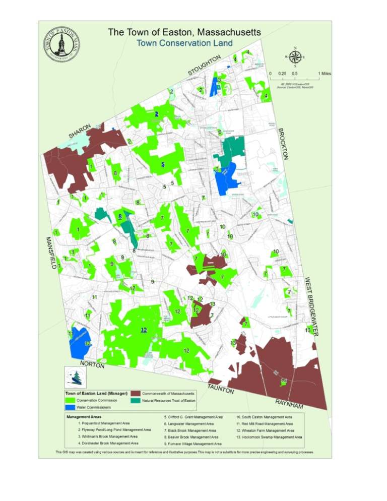
2 5 8 12 Conservation Management Areas 13. Hockomock Swamp Management Area: 1. Poquanticut Management Area: 7. Black Brook Management Area: This area consists of roughly 256 acres and contains the “Willis Buck Lot.” Most of the land is swampy and contains various forms of wildlife, including the threatened marbled salamander. Some of the land by Eastman Street extends into Norton. There are few trails in the area. Consisting of just over 406 acres, this land is the main drainage area for Black Brook. Most of the land is swampy, making it difficult to traverse, but wildlife abounds in the area. The largest named parcel is Metacomet, a gift to the town, and is accessible from Summer Street. The land is a key connection between the Hockomock Swamp and Borderland State Park. . 2. Flyaway Pond/Long Pond Management Area: The area consists of approximately 318 acres of land including noteworthy parcels such as Flyaway Pond, Long Pond, Tufts Farm, and Pout Rock. Consisting of varying amounts of upland, wetland, and bodies of water, the land provides an interesting variety of wildlife. Interestingly, Ames Long Pond is the only registered site in the state for an aquatic plant, “Eaton’s Quillwort,” which was registered on the Massachusetts Natural Heritage Program. Tufts Farm has a small network of trails on it and Ames Long Pond makes a good recreational spot for a day of swimming or beach activities. 3. Whitman’s Brook Management Area: Located east of the old railroad tracks near the Stoughton Line, the area is mainly the remnants of subdivisions and the water department owns part of the land. Unless you live nearby, the land is hard to access and is mostly wet. 4. Dorchester Brook Management Area: The lands in this parcel are scattered gifts from developers and consists of about 95 acres. Two notable properties, though, are “Stonehedge” and Monte’s Pond. Monte’s Pond was part of the last largest commercial ice harvesting business in New England. It is possible to walk the land, but difficult. Dogs must be leashed. All waste must be removed. The area, which consists of nearly 99 acres, acts as a drainage area for part of Beaver Brook. Some of the land, which is owned by NRT, continues down to Beaver Dam Road and the stream continues south, eventually emptying into Old Pond. It is claimed the last bear in Easton was shot on Fox Mountain Lot, which is part of this area. The area consists of both swamp and upland and has several access points. *Hunting with shotguns is permitted in conformance with Massachusetts State Laws. 9. Furnace Village Management Area: This area, made up of almost 140 acres, contains part of the “Furnace Village National Historic District.” Included in the land are Old and New Pond, two valuable recreation and conservation sites. Both the ponds have a history in iron making and add to the site’s value as a tribute to Easton’s heritage. It is possible to hike around both ponds, as well as fish them. 5. Clifford G. Grant Management Area: The Oliver Ames Parker Reservation, the Town Forest, and the Clifford G. Grant Reservation make up the majority of this 320acre management area. The parcels are within close walking distance of parking and abut the Easton Public Schools and the baseball fields. Trails crisscross the entire management area and make it one of the most accessible open spaces in the town. The area also contains Hogshead spring, which is the beginning of Black brook, and can be found just off the trails. These 27 acres of land abut Water Department holdings in the Canoe River aquifer. Most of the land is swampy, but an access road provides easy access into the area for walking. Some of the land extends several miles into Norton. This property, which was a gift of Oliver F. and Esther Ames, provides the finest vista in Easton. The vista is cleared of brush and is situated on the rim of an extinct volcano. The land also abuts Fred’s Pond, which is near the historic Ames Gate House. 12. Wheaton Farm Management Area: Wheaton Farm is the largest management area owned by the town and consists of nearly 1,034 acres of land. The land is named for Daniel Wheaton and was the Conservation Commission’s first major purchase. Most of the area acquired by the Commission was once used for local agriculture. The times at which owners discontinued maintenance on the plots have created successional stages of forests in the area. Some of the land includes trail systems and all of it is home to an abundance of wildlife. Conservation Commission Members Natural Resource Trust Land Most of the lands held by NRT are open for public use and are well maintained and accessible. Noteworthy properties include Sheep Pasture, Beaver Brook Woods, and Packard Farm. Sheep Pasture is commonly used as an environmental education center and hosts the annual NRT fair, which is renowned for the vendors and crowds it draws. (Rec. Rating – Four Stars) For More Information: http://www.nrtofeaston.org/ home.html Patricia Haederle, LSP, Chair Dr. Kyla Bennett, Vice Chair John Grant Jonathan Chace Michael Ganshirt Stephanie Danielson, Land Use Agent Telephone: (508) 230 0640 State Land in Easton, MA 10. South Easton Management Area: Obtained mostly through gifts from developers, this management area has parcels scattered all throughout South Easton. The 54 acres of land is mostly swampy and the largest parcel is “Settler’s Pond.” 2009 Prohibited Uses of Conservation Land: motorized vehicles (including ATVs and dirt bikes), fires, camping, target shooting, use of firearms*, and removal of animals, plants, trees, shrubs, and rock materials 8. Beaver Brook Management Area: 11. Red Mill Road Management Area: 6. Langwater Management Area: The town holdings in this area are scattered; total only about 25 acres and are mostly accessible only through the abutting state land. Easton Massachusetts The State owns two major areas in Easton, Borderland State Park and parts of the Hockomock Swamp. Borderland State Park is known for its well-kept trails and vast acreage, all open for public use. The Hockomock Swamp is considered an Area of Critical Environmental Concern, and therefore is less open to the public, but one can walk the old rail-bed. For More Information: http://www.mass.gov/dcr/parks/ borderland/ Conservation Commission Ratings Each parcel is assigned a certain number of stars, ranging from one star (the lowest) to five stars (the highest). In order to determine the rating, the following factors were taken into account: how easily accessible the trails are, the condition of the trails, the availability of parking, the historical value of the land, and other recreational possibilities available on each lot. The star rating is subjective and liable to change over time. One Four Two Five Three Website: <http://www.easton.ma.us/Directory/ concomm/ConCommFS.htm> “It is with the deepest admiration, respect and gratitude that the Easton Conservation Commission dedicates this brochure to John E. Grant. John has been and continues to be instrumental in the preservation of over 2,500 acres of conservation land in the Town of Easton. A resident of Easton for nearly fifty years, John has served the Conservation Commission forty of those years -- the longest serving Commissioner in the Commonwealth. He continues to work tirelessly with land owners and townsfolk to acquire critical parcels for habitat and open space preservation. Through his perseverance and dedication, John influenced generations of volunteers to protect Easton’s character through land preservation and contribute to a legacy that will benefit generations to come.” ~ Easton Conservation Commission, August 2009.
