Lecture 5
advertisement
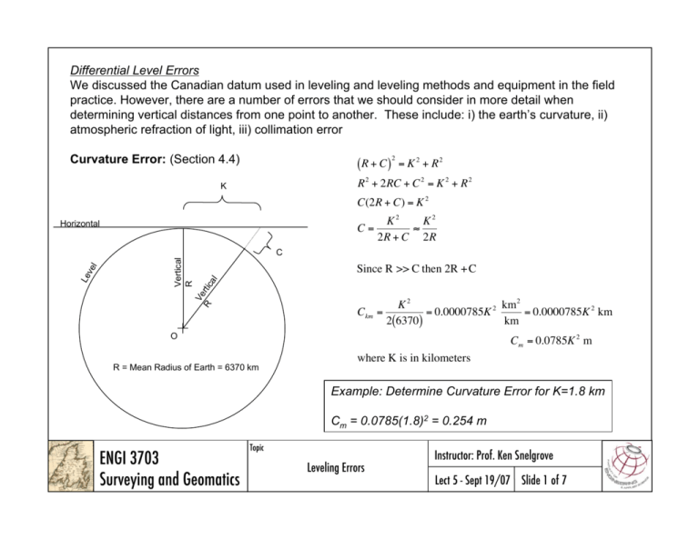
Differential Level Errors We discussed the Canadian datum used in leveling and leveling methods and equipment in the field practice. However, there are a number of errors that we should consider in more detail when determining vertical distances from one point to another. These include: i) the earth’s curvature, ii) atmospheric refraction of light, iii) collimation error Curvature Error: (Section 4.4) (R + C ) 2 = K 2 + R2 R 2 + 2RC + C 2 = K 2 + R 2 K C(2R + C) = K 2 Horizontal C= K2 K2 2R + C 2R Vertical R Ve rti ca l Since R >> C then 2R + C R Le ve l C Ckm = K2 km2 = 0.0000785K 2 = 0.0000785K 2 km 2(6370) km O Cm = 0.0785K 2 m R = Mean Radius of Earth = 6370 km where K is in kilometers Example: Determine Curvature Error for K=1.8 km Cm = 0.0785(1.8)2 = 0.254 m ENGI 3703 Surveying and Geomatics Topic Leveling Errors Instructor: Prof. Ken Snelgrove Lect 5 - Sept 19/07 Slide 1 of 7 Refraction Error: (Section 4.4) Light waves are bent as they move from one medium to another. The atmosphere cools and has lower pressure as we rise in the atmosphere. This tends to refract light upward away the surface. This makes objects (such as a rod readings!) appear higher then they actually are. In an atmosphere of constant density there would be no refraction. While the effect is temperature, humidity and pressure controlled, it is approximated as 1/7 of the curvature of the earth acting in the opposite direction of curvature 1 (0.0785)K 2 7 = 0.011K 2 Rm = The two effects are often combined to give : hm = 0.0785K 2 0.011K 2 = 0.0675K 2 m where K is in kilomters Example: Determine Refraction and Combined Error for K=1.8 km Rm = 0.011(1.8)2 = 0.036 m hm = 0.0675(1.8)2 =0.218 m ENGI 3703 Surveying and Geomatics Topic Leveling Errors Instructor: Prof. Ken Snelgrove Lect 5 - Sept 19/07 Slide 2 of 7 Collimation Error: (Section 4.15.5) While we assume that our level instrument, when leveled, shoots along a horizontal line, there is no guarantee of this. The cross hairs many be out of alignment, the leveling tube may not be in line with the optics of the instrument (figure 4.11), the automatic compensation (figure 4.15) mechanism may be sticking. Each of these many result in a collimation error. A test for this is known as the peg test. The peg test involves setting two points (A & B) and taking level reading from two positions (1&2). If the collimation error (e) is zero the apparent elevation of points will not be influenced by the distance from them. If an error exists it will double if the distance from the shot is doubled. rA e = RB 2e Set - up 1 RA 2e = rB e Set - up 2 solving both for e : e = RB rA e = RA rB adding the two equations gives : 2e = RB rA + RA rB or R r r + RA e= B A B 2 Note : Example 4.3 p.98 ENGI 3703 Surveying and Geomatics Topic Leveling Errors Instructor: Prof. Ken Snelgrove Lect 5 - Sept 19/07 Slide 3 of 7 Correcting Curvature, Refraction and Collimation Errors (Section 5.4) A procedure for negating these errors, is to balance foresights and backsights in differential leveling. Since these errors are dependent on distance and differential errors subtracts foresights and backsights then these errors would tend to cancel. Of course this assumes that: i) the atmospheric conditions are the same, ii) the curvature of the earth is constant, and iii) the collimation error is constant. Leveling Precision (Section 5.5) Differential leveling is run to a bench mark and back to the original reference. The difference in the sum of foresights and the sum of backsights is the “closure error”. Allowable error depend on the application and Canadian Specification follow US (FGCS) specifications with different naming convention. Both compute allowance misclosure as a function of distance covered in the loop as: C = ±m K ENGI 3703 Surveying and Geomatics Topic Leveling Errors where: C is allowable misclosure (mm) m is an integer 3, 4, 8, 24, 120 K is loop length in (km) Instructor: Prof. Ken Snelgrove Lect 5 - Sept 19/07 Slide 4 of 7 Canadian Spatial Reference System Specifications and Recommendations for Control Surveys and Survey Markers http://www.geod.nrcan.gc.ca/stand/survey_specs_e.pdf Type Allowable Misclosure (m) Total Difference between backsight and foresight distances Special Equipment Required Longest foresight / backsight Special Order 3 mm 5m 40X Zoom 10"/2 mm level 1mm Invar rod Steel pin T.P. Sun Shade 50m First Order 4 mm 10 m 32X Zoom 10"/2 mm level 1cm Invar rod Sun Shade 110m (three wire) Second Order 8 mm 10 m 20"/2 mm level 110m (three wire) Third Order 24 mm unspecified 20"/2 mm level unspecified Fourth Order 120 mm unspecified 50”/2 mm level unspecified ENGI 3703 Surveying and Geomatics Topic Leveling Errors Instructor: Prof. Ken Snelgrove Lect 5 - Sept 19/07 Slide 5 of 7 Converting Distance Closure to Number of Setups (Section 5.5) If we know the average foresight / backsight distance in the level loop we can determine the closure error per set-up rather than total distance. Example: For first order closure (4 mm per ilometer), determine the allowable error per set-up with the maximum foresight / backsight distance (110m) was used. Solution: Set ups are spaced 220 m apart therefore 1000m/220m = 4.55 setups/km would be required. ENGI 3703 Surveying and Geomatics C = ±4 K n n C = ±4 1 n = ±1.88 n 4.55 Topic Leveling Errors Instructor: Prof. Ken Snelgrove Lect 5 - Sept 19/07 Slide 6 of 7 Leveling Errors - Summary (Section 5.12) Systematic (S) Random (R) Instrument Error Collimation (S,R) Horizontal Cross Hair (R) Short/Long Rod (S) Natural Error Refraction & Curvature (S,R) Temperature (R) Wind (R) Settlement (S) Personal Error Failure to Fine Level (R) Parallax (focus) (R) Rod Reading (R) Rod Handling (R) Level Mistakes: Rod not extended, poor turning point locations, misreading rod by 1 m, waving rod on flat surface, transposing figures in note, reading bias on rod, touching instrument and legs. Error Reducing Leveling Techniques 1. Three-Wire Leveling (averaging 3 readings) 2. Reciprocal Leveling (when FS and BS do not balance) 3. Rod Plumbing and Rocking 4. Repeated Measurements and Distribute Error Other Leveling Methods 1. Barometric (+/- 1m) 2. Trigonometric Leveling (OK for short shots [i.e. big vertical angle change per unit height diff.]) ENGI 3703 Surveying and Geomatics Topic Leveling Errors Instructor: Prof. Ken Snelgrove Lect 5 - Sept 19/07 Slide 7 of 7
