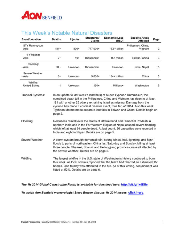
This Week’s Notable Natural Disasters
Deaths
Injuries
Structures/
Claims
Economic Loss
(USD)
Specific Areas
Affected
181+
800+
777,000+
6.5+ billion
Philippines, China,
Vietnam
2
TY Matmo:
- Asia
2+
10+
Thousands+
15+ million
Taiwan, China
3
Flooding:
- Asia
34+
Unknown
Thousands+
Unknown
India, Nepal
5
3+
Unknown
5,000+
134+ million
China
5
1
Unknown
150+
Millions+
Washington
6
Event/Location
STY Rammasun:
- Asia
Severe Weather:
- Asia
Wildfire:
- United States
Page
Tropical Systems:
In an update to last week’s landfall(s) of Super Typhoon Rammasun, the
combined death toll in the Philippines, China and Vietnam has risen to at least
181 with another 25 others remaining listed as missing. Damage from the
cyclone has made it costliest disaster event, thus far, of 2014. Also this week,
Typhoon Matmo made separate landfalls in Taiwan and China. Details begin on
page 2.
Flooding:
Relentless rainfall over the states of Uttarakhand and Himachal Pradesh in
northern India and in the Far Western Region of Nepal caused severe flooding
which left at least 34 people dead. At last count, 26 casualties were reported in
India and eight in Nepal. Details are on page 5.
Severe Weather:
A storm system brought torrential rain, strong winds, hail, lightning, and flash
floods to parts of northeastern China last Saturday and Sunday, killing at least
three people. Shaanxi, Shanxi, and Heilongjiang provinces were all affected by
the severe weather. Details are on page 5.
Wildfire:
The largest wildfire in the U.S. state of Washington’s history continued to burn
this week, as local officials reported that the blaze had charred an estimated 150
homes. One fatality was attributed to the fire. As of this writing, containment was
listed at 52%. Details are on page 6.
The 1H 2014 Global Catastrophe Recap is available for download here: http://bit.ly/1x0DIfe
To watch Aon Benfield meteorologist Steve Bowen discuss 1H 2014 losses, click here.
Impact Forecasting | Weekly Cat Report: Volume 14, Number 30 | July 25, 2014
1
Update on STY Rammasun; TY Matmo strikes Taiwan & China
STY Rammasun
In an update to last week’s landfall(s) of Super Typhoon Rammasun, the combined death toll in the
Philippines, China and Vietnam has risen to at least 181 with another 25 others remaining listed as
missing. Rammasun was the ninth named storm and third typhoon of the Western North Pacific typhoon
season, and the combined USD6.5 billion in economic damages currently make this the costliest global
natural disaster event of 2014.
Meteorological Recap
Following Rammasun’s landfall in the Philippines,
it emerged over the South China Sea looking
slightly disorganized on July 16 with maximum
sustained winds speeds estimated at 150 kph (90
mph). It moved steadily northwestward across the
South China Sea and, due to warm sea surface
temperatures, low vertical wind shear, and a
favorable upper level environment, it had
intensified sufficiently on July 18 to be classified
by the Joint Typhoon Warning Center (JTWC) as
a super typhoon with maximum sustained wind
speeds of 250 kph (155 mph). Shortly afterwards,
Rammasun made its second landfall near
Wenchang City, Hainan Island, China, at 15:30
CST (07:30 UTC). The system then made a third
Super Typhoon Rammasun prior to its second landfall. (Source: NASA)
landfall on China’s Luichow Peninsula,
Guangdong Province, with maximum sustained winds of 230 kph (145 mph) – equivalent to a Category 4
hurricane. As Rammasun emerged in the Gulf of Tonkin, interaction with the rugged terrain of southern
China caused the system to weaken. When it made its final landfall over near Fangchenggang City,
Guanxi Zhuang Autonomous Region at 07:30 CST (23:30 UTC 18 July) on 19 July, maximum sustained
winds were estimated at 185 kph (115 mph) – equivalent to a Category 3 hurricane. As the system moved
inland across Guanxi, Yunnan Province, and northern Vietnam, it dissipated rapidly and was no longer
recognized by the JTWC after July 20.
Event Details
Philippines
Updated figures released by the National Disaster Risk Reduction and Management Center (NDRRMC)
indicate that more than four million people were affected across Philippines, where 98 people were killed
and 630 were injured as a result of the storm. Five others are still missing. The worst of the damage was
sustained in Quezon Province, on the eastern side of Luzon Island. Across Philippines seven provinces,
two cities, and twelve municipalities are in an official “state of calamity”. Nearly 500,000 properties were
damaged as the typhoon passed through the archipelago, including 102,363 which were destroyed.
The NDRRMC has updated its economic damage estimate to infrastructure, agriculture and public
schools alone to PHP10.8 billion (USD250 million). The breakdown included: PHP1.6 billion (USD37
million) to infrastructure; PHP6.4 billion (USD212 million) to agriculture (crops and livestock); and
PHP28.1 million (USD650,000) to schools in the region.
Impact Forecasting | Weekly Cat Report: Volume 14, Number 30 | July 25, 2014
2
China
Across southern China, more than
11 million people were directly
affected by the passage of Super
Typhoon Rammasun. The latest
casualty count included 56 people
dead (nine in Guangxi, 18 in
Yunnan, and 19 on Hainan Island),
and 20 others still listed missing.
On Hainan Island alone, 3.25
million people were affected,
39,000 properties were damaged
and 1.13 million people were left
without power as Rammasun
crossed the island. In Yunnan, 14 of
the reported deaths were caused by
two landslides triggered by the
Flooding in China from STY Rammasun (Source: Alertnet)
torrential rainfalls that Rammasun
brought to the region. One landslide in Manghai Town killed 13 people, injured seven, and left seven
others missing as it brought down 13 properties and seriously damaged dozens more. The second
landslide occurred in the city of Yuxi and buried five members of one family as it toppled their home. At
the time of writing only one body had been recovered.
Data from the Ministry of Civil Affairs (MCA) indicated that a combined 272,000 homes were damaged or
destroyed by Rammasun in the provincial regions of Hainan, Guangdong, Yunnan, and Guangxi.
Agriculture was heavily affected as well with 258,000 hectares (638,000 acres) of crops destroyed. Total
economic losses were listed at CNY38.5 billion (USD6.2 billion). Preliminary data from the China
Insurance Regulatory Commission (CIRC) indicated that CNY694 million (USD11.2 million) in claims had
been filed in Hainan alone, though this total was expected to substantially rise across south China.
Vietnam
In Vietnam, the town of Mong Cai (close to the Chinese border and near where Rammasun made its final
landfall) was worst affected. In Quang Ninh Province, 27,000 people were evacuated prior to the typhoon
hitting the area. In total, 27 people died in Vietnam from the storm’s impacts – primarily from flooding,
landslides and lightning strikes. Several others were injured or listed as missing. Damage was sustained
to more than 7,200 properties, including 700 that were completely destroyed. Damage to infrastructure
and crop losses were also sustained. Total economic losses were listed at VND125 billion (USD6.2
million).
TY Matmo
Typhoon Matmo made landfall in Taiwan and China this week after first passing by the Philippines. Two
fatalities and more than a dozen injuries were attributed to Matmo, which was the tenth named storm of
the Western North Pacific typhoon season and the fourth storm to reach typhoon intensity. It was the third
typhoon in the Western North Pacific basin so far this month, and the first typhoon to strike Taiwan since
Typhoon Soulik last July. Both storms were of a similar intensity when they made landfall in Taiwan.
Impact Forecasting | Weekly Cat Report: Volume 14, Number 30 | July 25, 2014
3
Meteorological Recap
Typhoon Matmo developed from a tropical disturbance
that appeared in the Inter-Tropical Convergence Zone
(ITCZ) over the Philippines Sea on July 13. It slowly
gathered strength and began to move westward and by
July 16, the Joint Typhoon Warning Center (JTWC)
recognized the system as a tropical depression. The
following day, JTWC upgraded the system to Tropical
Storm 10W and it was named Matmo by the Japan
Meteorological Agency (JMA). Early on July 18, it
entered the Philippines Area of Responsibility (PAR) and
was locally named “Henry”. The following day, Tropical
Storm Matmo changed track and started moving towards
the northwest. At the same time, the organization of the
system began to increase and convection deepened,
leading JTWC to upgrade the system to typhoon
TY Matmo crossing Taiwan (Source: NASA)
intensity. Matmo continued on its northwestward track
across the Philippines Sea on July 21 maintaining maximum sustained wind speeds of 130 kph (80 mph).
The intensity of the system increased on July 22 when it attained maximum sustained wind speeds of 160
kph (100 mph) (the equivalent of a Category 2 hurricane) as it approached Taiwan. It landed in
Chenggong Township, Taitung County, on Taiwan’s east coast shortly after midnight on July 23 with wind
speeds of around 150 to 160 kph (90 to 100 mph).
The typhoon crossed Taiwan and emerged in the Taiwan Strait on July 23 (local time) while maintaining
maximum sustained winds of 130 kph (80 mph). Matmo quickly crossed the Taiwan Strait and made its
final landfall in Fujian Province, China, between Putian and Fuzhou, at about 15:30 CST (local time)
(07:30 UTC), with wind speeds of 120 kph (75 mph) – equivalent to a weak Category 1 hurricane. Upon
making landfall, the system quickly lost strength and organization due to the frictional effects of land and
within 12 hours had weakened to tropical storm strength with winds of 75 kph (45 mph). The system
continued to weaken rapidly as it turned to the north and had fully dissipated as a significant system by
the evening hours of July 24 (local time).
Event Details
Although the storm did not directly strike the Philippines, some damage was still incurred as convective
rainbands from Matmo swept across the northern islands. Two children were killed by a landslide in
Rodriguez Rown, Rizal Province. The slide was triggered by the intense rainfall from Matmo, which fell on
soil that was already saturated by rainfall from Typhoon Rammasun which passed over the region last
week. Only 132 properties sustained damage, and there was also disruption to transport services and
power supplies.
In Taiwan, the effects of Typhoon Matmo were felt across the whole island. Rainfall was excessive in
many areas with totals including: 580 millimeters (22.83 inches) in Ci-en in Xiulen Township; 537
millimeters (21.14 inches) in Buluowan, Xiulin Township; 534 millimeters (21.02 inches) at Mount Taiping,
Yilan County; and 523 millimeters (20.59 inches) in Hongye, Hualien County. Wind gusts of up to 212 kph
(132 mph) were recorded on Orchid Island, just southeast of the main island of Taiwan, as Matmo
approached on Tuesday afternoon. Gusts of 172 kph (107 mph) were recorded in Chenggong shortly
after the system made landfall.
Impact Forecasting | Weekly Cat Report: Volume 14, Number 30 | July 25, 2014
4
Despite the heavy rains and high winds, no deaths in Taiwan were directly attributed to the typhoon. Ten
people were reported injured, primarily as a result of falling trees/debris. Power, water, and
telecommunications services were severely disrupted across the country; while roads and rail service was
impacted by landslides and flooding. Agriculture was also heavily affected.
As the storm made its final landfall near Putian, Fujian Province, China it continued to bring the torrential
rain and damaging winds that ravaged Taiwan. In Fuzhou, close to where the system made landfall, 150
millimeters (5.90 inches) of rain was recorded from 8:00 AM CST 23 July to 8:00 AM CST 24 July. Wind
gusts there were reported to be 90 kph (55 mph) prior to Matmo’s landfall. In Jiuxian Shan, approximately
110 kilometers (70 miles) inland from Putian, the rainbands of Matmo brought 147 millimeters (5.79
inches) of rain in 24 hours. Prior to the storms landfall, almost 300,000 people were evacuated from
vulnerable areas of Fujian Province. All shipping services in the region were suspended and 90 flights to
and from Fuzhou’s Changle International Airport were cancelled. In Zhejiang, 44,000 people were
evacuated and 30,000 vessels were instructed to return to shore before Matmo struck the province.
Across southeastern China, a number of resort islands were evacuated and rail services were suspended
in coastal areas. Early reports from the Ministry of Civil Affairs (MCA) indicated that several thousands of
properties were damaged.
Financial Losses
Economic losses attributed to agricultural damage in Taiwan were estimated at TWD430 million (USD14
million). In China, the MCA indicated that preliminary economic losses were roughly CNY800 million
(USD129 million).
Flooding rains leave 34 dead in India and Nepal
Relentless rainfall over the states of Uttarakhand and Himachal Pradesh in northern India and in the Far
Western Region of Nepal caused severe flooding which left at least 34 people dead. At last count, 26
casualties were reported in India and eight in Nepal. The rains started on July 16 and did not relent until
the middle of this week. In a 48-hour period from 12:00 UTC 18 July to 12:00 UTC 20 July, more than 280
millimeters (11.02 inches) of rain was recorded at Dadeldhura, Nepal.
In Nepal, the Sharda River (also known as the Makahali River), which flows along the Indian-Nepal
border, burst its banks causing flooding that damaged around 900 properties and destroyed 40 others.
Many roads and highways in the region were closed due to flooding and landslides leaving around 6,000
people stranded as they tried to make pilgrimages to Hindu shrines in the Himalayan Mountains.
In June 2013, flooding in the same region left an estimated 7,000 people dead and caused economic
losses of INR112 billion (USD1.91 billion), of which INR36 billion (USD585 million) was insured.
Severe thunderstorms leave three dead in China
A storm system brought torrential rain, strong winds, hail, lightning, and flash floods to parts of
northeastern China last Saturday and Sunday, killing at least three people. Shaanxi, Shanxi, and
Heilongjiang provinces were all affected by the severe weather. In Heilongjiang alone, 366,000 people
were affected by the storms that left three people dead and one other person missing in the province. The
hail and driving rain caused over 600 houses to collapse and left 2,200 other properties with varying
degrees of damage. In addition, severe damage was sustained to crops, in particular, fruit trees. The
MCA estimated the combined economic losses at CNY830 million (USD134 million).
Impact Forecasting | Weekly Cat Report: Volume 14, Number 30 | July 25, 2014
5
Largest wildfire in Washington history destroys 150 homes
The largest wildfire in the U.S. state of Washington’s history continued to burn this week, as local officials
reported that the blaze had charred an estimated 150 homes. The Carlton Complex Fire actually consists
of four separate fires (Stokes Road, Golden Hike, French Creek, and Cougar Flat) in the Methow Valley
region of Okanogan County that were triggered by lightning strikes on July 14. The fires eventually
converged into one singular blaze in largely rural central Washington. As of this writing, the fire had
charred more than 250,258 acres (101,276 hectares) of land and was burning across timber, sage and
grass. Containment was listed at 52%. Nearly all of the roughly 150 homes were destroyed on July 17 in
and around the communities of Pateros and Malott as extremely hot temperatures and gusty winds
caused the fire to rapidly spread out of control. One fatality was blamed on the fire.
Current Global Sea Surface Temperature Anomalies (°C)
(Graphic provided by NOAA/NESDIS)
Sea Surface Temperature and Anomaly Values for Selected Locations
(Information provided by the Tropical Ocean Atmospheric Project and the National Data Buoy Center)
Temperature (°C)
Departure From
Last Year (°C)
Eastern Pacific Ocean (555 miles southwest of San Salvador, El Salvador)
29.2
+1.1
Tropical Atlantic Ocean (1,590 miles east-southeast of Trinidad)
25.4
-0.2
Western Gulf of Mexico (60 miles southeast of Corpus Christi, Texas)
29.2
+0.7
Eastern Gulf of Mexico (130 miles east-southeast of Pensacola, Florida)
29.4
+0.7
Carolinas Coastline (45 miles southeast of Charleston, South Carolina)
29.0
N/A
Northeastern United States (15 miles southeast of Portland, Maine)
16.7
-3.7
Location of Buoy
Additional information: http://www.fnmoc.navy.mil/public/
Impact Forecasting | Weekly Cat Report: Volume 14, Number 30 | July 25, 2014
6
Current Tropical Systems
(Graphic provided by Impact Forecasting)
Tropical System Location and Intensity Information
(Information provided by the National Hurricane Center and the Joint Typhoon Warning Center)
Name*
Location
Winds
Circulation Center Reference Point
Movement**
Trend
* TD = Tropical Depression, TS = Tropical Storm, HU = Hurricane, TY = Typhoon, STY = Super Typhoon, CY = Cyclone
** N = North, S = South, E = East, W = West, NW = Northwest, NE = Northeast, SE = Southeast, SW = Southwest
Additional tropical system information:
•
http://www.nhc.noaa.gov (Atlantic, Caribbean and Eastern Pacific storms)
•
http://www.usno.navy.mil/JTWC (Central and Western Pacific and Indian Ocean storms)
Impact Forecasting | Weekly Cat Report: Volume 14, Number 30 | July 25, 2014
7
Global Tropics Outlook
(Graphic provided by the Climate Prediction Center)
Impact Forecasting | Weekly Cat Report: Volume 14, Number 30 | July 25, 2014
8
Earthquake Activity: July 18 – July 24
(Graphic provided by Impact Forecasting)
Significant Earthquake Location and Magnitude (≥M6.0) Information
(Information provided by the United States Geological Survey)
Date
Location
Magnitude
Depth
Epicenter
Reference Point
Comments
7/19/14
15.799°S
174.404°W
6.0
219.8 km
72 kilometers (45 miles) westnorthwest of Hihifo, Tonga
No major damage reported.
7/19/14
11.752°N
57.563°E
6.0
10.0 km
396 kilometers (246 miles)
east-southeast of Tamrida,
Yemen
No major damage reported.
7/21/14
44.599°N
148.748°E
6.2
70.0 km
98 kilometers (61 miles)
southeast of Kuril'sk, Russia
No major damage reported.
7/21/14
19.829°S
178.464°W
6.9
616.4 km
94 kilometers (58 miles) northnortheast of Ndoi Island, Fiji
No major damage reported.
Additional earthquake information: http://earthquake.usgs.gov/earthquakes/map/
Impact Forecasting | Weekly Cat Report: Volume 14, Number 30 | July 25, 2014
9
U.S. Weather Threat Outlook
(Graphic provided by the Climate Prediction Center)
Threats
The combination of a slow-moving frontal boundary and an upper level area of low pressure will
lead to multiple days of heavy rain chances for portions of the Northeast and Mid-Atlantic states
over the weekend. Additional heavy rains along the tail end of the boundary will be found in the
central and southern Plains as monsoonal moisture interacts with the front.
Though not shown on the above map, there will be a severe weather threat for portions of the
Midwest, Plains and Ohio Valley on Saturday.
Persistent ridging in the Pacific Northwest will lead to continued well above normal temperatures
in the region. The hot temperatures will also cause an increased risk for wildfires.
Severe drought conditions linger for most of the West and parts of the southern Plains. No
significant drought relief is expected out west during the next seven days.
Impact Forecasting | Weekly Cat Report: Volume 14, Number 30 | July 25, 2014
10
Current U.S. Watches, Warnings and Advisories
(Graphic provided by the National Weather Service)
Additional watch, warning and advisory information: http://www.spc.noaa.gov/products/wwa/
Impact Forecasting | Weekly Cat Report: Volume 14, Number 30 | July 25, 2014
11
Current U.S. River Flood Stage Status
(Graphic provided by Impact Forecasting)
Top 5 Rivers Currently Nearing or Exceeding Flood Stage
(Information provided by the United States Geological Survey)
Flood Stage
Current Stage
Percent of
Full Capacity
Souris River near Westhope, North Dakota
10.00
14.10
141%
Menominee River near Iron Mountain, Michigan
12.00
15.18
127%
Willow Creek near Willow City, North Dakota
10.00
11.43
114%
Souris River near Bantry, North Dakota
11.00
12.29
112%
8.00
8.89
111%
Location
Cypress Creek at Worthington Gardens, Florida
Additional river flood information: http://water.usgs.gov/waterwatch/
Impact Forecasting | Weekly Cat Report: Volume 14, Number 30 | July 25, 2014
12
Source Information
Update on STY Rammasun; TY Matmo strikes Taiwan & China:
Typhoon Rammasun death toll hits 33 in China, Xinhua News Agency
Strongest storm in decades in south China kills 18, Associated Press
Death toll by typhoon Rammasun rises to 11 in Vietnam, Xinhua News Agency
Typhoon kills 11 in Vietnam; China deaths up to 33, Associated Press
27 killed by typhoon Rammasun in Vietnam so far, Xinhua News Agency
China Typhoon Rammasun death toll rises to 46, Xinhua News Agency
Typhoon Rammasun incurs huge economic losses in China, Xinhua News Agency
Typhoon Matmo Slams into Taiwan, One Killed, Some Damage Reported, Reuters
2 killed in landslide in N. Philippines, Xinhua News Agency
China braces for Typhoon Matmo, Xinhua News Agency
Joint Typhoon Warning Center
Philippines’ National Disaster Risk Reduction and Management Council
China’s Ministry of Civil Affairs
Vietnam’s Disaster Management Center
Flooding rains leave 34 dead in India and Nepal:
2 killed in flooding in N. India, Xinhua News Agency
8 More Flood Deaths in Nepal, FloodList
India’s National Disaster Management
Severe thunderstorms leave three dead in China:
NE China downpour kills two, affects 98,000, Xinhua News Agency
Damage of downpour in NE China worsening, Xinhua News Agency
China’s Ministry of Civil Affairs
Largest wildfire in Washington history destroys 150 homes:
The Carlton Complex Fire is the largest in WA state history, KLEW
InciWeb
GeoMAC
Impact Forecasting | Weekly Cat Report: Volume 14, Number 30 | July 25, 2014
13
Additional Report Details
TD = Tropical Depression, TS = Tropical Storm, HU = Hurricane, TY = Typhoon, STY = Super Typhoon, CY = Cyclone
Fatality estimates as reported by public news media sources and official government agencies.
Structures defined as any building – including barns, outbuildings, mobile homes, single or multiple family dwellings, and commercial facilities – that is
damaged or destroyed by winds, earthquakes, hail, flood, tornadoes, hurricanes or any other natural-occurring phenomenon. Claims defined as the
number of claims (which could be a combination of homeowners, commercial, auto and others) reported by various insurance companies through
press releases or various public media outlets.
Damage estimates are obtained from various public media sources, including news websites, publications from insurance companies, financial
institution press releases and official government agencies. Economic loss totals include any available insured loss estimates, which can be found in
the corresponding event text.
About Impact Forecasting®: Impact Forecasting is a catastrophe model development center of excellence within Aon Benfield whose seismologists,
meteorologists, hydrologists, engineers, mathematicians, GIS experts, finance, risk management and insurance professionals analyze the financial
implications of natural and man-made catastrophes around the world. Impact Forecasting’s experts develop software tools and models that help clients
understand underlying risks from hurricanes, tornadoes, earthquakes, floods, wildfires and terrorist attacks on property, casualty and crop insurers and
reinsurers. Impact Forecasting is the only catastrophe model development firm integrated into a reinsurance intermediary. To find out more about
Impact Forecasting®, visit www.impactforecasting.com.
About Aon Benfield: Aon Benfield, a division of Aon plc (NYSE: AON), is the world’s leading reinsurance intermediary and full-service capital advisor.
We empower our clients to better understand, manage and transfer risk through innovative solutions and personalized access to all forms of global
reinsurance capital across treaty, facultative and capital markets. As a trusted advocate, we deliver local reach to the world’s markets, an unparalleled
investment in innovative analytics, including catastrophe management, actuarial and rating agency advisory. Through our professionals’ expertise and
experience, we advise clients in making optimal capital choices that will empower results and improve operational effectiveness for their business. With
more than 80 offices in 50 countries, our worldwide client base has access to the broadest portfolio of integrated capital solutions and services. To
learn how Aon Benfield helps empower results, please visit aonbenfield.com.
Cat Alerts use publicly available data from the internet and other sources. Impact Forecasting® summarizes this publicly available information for the
convenience of those individuals who have contacted Impact Forecasting® and expressed an interest in natural catastrophes of various types. To find
out more about Impact Forecasting or to sign up for the Cat Reports, visit Impact Forecasting’s webpage at www.impactforecasting.com.
Copyright © by Impact Forecasting®. No claim to original government works. The text and graphics of this publication are provided for informational
purposes only. While Impact Forecasting® has tried to provide accurate and timely information, inadvertent technical inaccuracies and typographical
errors may exist, and Impact Forecasting® does not warrant that the information is accurate, complete or current. The data presented at this site is
intended to convey only general information on current natural perils and must not be used to make life-or-death decisions or decisions relating to the
protection of property, as the data may not be accurate. Please listen to official information sources for current storm information. This data has no
official status and should not be used for emergency response decision-making under any circumstances.
Copyright © by Aon plc. All rights reserved. No part of this document may be reproduced, stored in a retrieval system, or transmitted in
any form or by any means, electronic, mechanical, photocopying, recording or otherwise. Impact Forecasting® is a wholly owned
subsidiary of Aon plc.
Impact Forecasting | Weekly Cat Report: Volume 14, Number 30 | July 25, 2014
14

