Word
advertisement
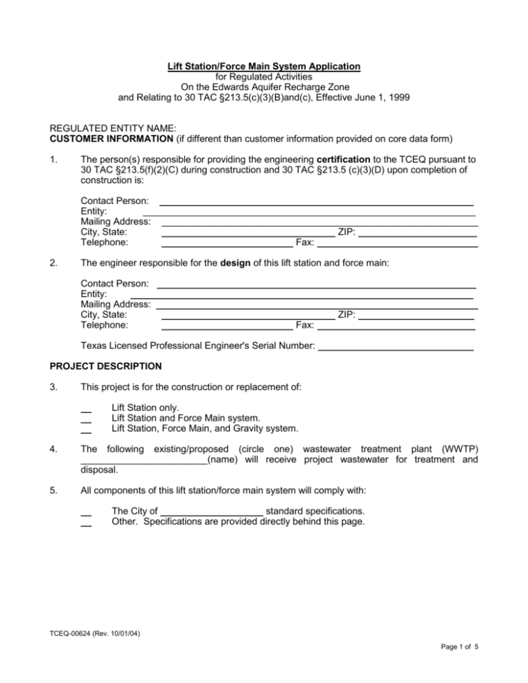
Lift Station/Force Main System Application for Regulated Activities On the Edwards Aquifer Recharge Zone and Relating to 30 TAC §213.5(c)(3)(B)and(c), Effective June 1, 1999 REGULATED ENTITY NAME: CUSTOMER INFORMATION (if different than customer information provided on core data form) 1. The person(s) responsible for providing the engineering certification to the TCEQ pursuant to 30 TAC §213.5(f)(2)(C) during construction and 30 TAC §213.5 (c)(3)(D) upon completion of construction is: Contact Person: ___________________________________________________________ Entity: _______________________________________________________________ Mailing Address: ____________________________________________________________ City, State: ZIP: ______________________ Telephone: Fax: ______________ _______________ 2. The engineer responsible for the design of this lift station and force main: Contact Person: ____________________________________________________________ Entity: ________________________________________________________________ Mailing Address: ____________________________________________________________ City, State: ZIP: __________ ___________ Telephone: Fax: _____________________________ Texas Licensed Professional Engineer's Serial Number: ____________________________ PROJECT DESCRIPTION 3. This project is for the construction or replacement of: Lift Station only. Lift Station and Force Main system. Lift Station, Force Main, and Gravity system. 4. The following existing/proposed (circle one) wastewater treatment plant (WWTP) ________________________(name) will receive project wastewater for treatment and disposal. 5. All components of this lift station/force main system will comply with: The City of standard specifications. Other. Specifications are provided directly behind this page. TCEQ-00624 (Rev. 10/01/04) Page 1 of 5 SITE PLAN Items 6 through 13 must be included on the Site Plan. 6. The Site Plan must have a minimum scale of 1" = 400'. Site Plan Scale: 1" = ‘. 7. Lift station/force main system layout shall meet all requirements of 30 TAC §213.5(c)(3)(B) and(C), and 30 TAC Chapter 317. 8. Geologic or Manmade Features: No geologic or manmade features were identified in the Geologic Assessment. All geologic or manmade features identified in the Geologic Assessment (caves, solution openings, sinkholes, fractures, joints, porous zones, etc.) which exist at the site of the proposed lift station and along the path(s) or within 50 feet of each side of a proposed force main line are shown on the Site Plan and are listed in the table below. Designs used to protect the integrity of the sewer line crossing each feature are described and labeled on the attached page. A detailed design drawing for each feature is shown on Plan Sheet of . No Geologic Assessment is required for this project. Line Station Station Type of Feature to to to to to to to to 9. Existing topographic contours are shown and labeled. The contour interval is feet. (Contour interval must not be greater than 5 feet). 10. Finished topographic contours are shown and labeled. The contour interval is feet. (Contour interval must not be greater than 5 feet). Finished topographic contours will not differ from the existing topographic configuration and are not shown. TCEQ-00624 (Rev. 10/01/04) Page 2 of 5 11. 100-year floodplain boundaries Some part(s) of the project site is located within the 100-year floodplain. The floodplain is shown and labeled. No part of the project site is located within the 100-year floodplain. The 100-year floodplain boundaries are based on the following specific (including date of material) sources(s): __________________________________________________________ ___________________________________________________________________________ ___________________________________________________________________________ ___________________________________________________________________________ 12. 5-year floodplain: After construction is complete, no part of this project will be in or cross a 5-year floodplain, either naturally occurring or manmade. (Do not include streets or concretelined channels constructed above sewer lines.) After construction is complete, all sections of the force main located within the 5-year floodplain will be encased in concrete or capped with concrete. These locations are listed in the table below and are shown and labeled on the Site Plan. (Do not include streets or concrete-lined channels constructed above sewer lines.) Line 13. Sheet Station Station of to of to of to of to All known wells (oil, water, unplugged, capped and/or abandoned, test holes, etc.): There are (#) wells present on the project site and the locations are shown and labeled. (Check all of the following that apply) The wells are not in use and have been properly abandoned. The wells are not in use and will be properly abandoned. The wells are in use and comply with 30 TAC §238. There are no wells or test holes of any kind known to exist on the project site. PLAN AND PROFILE SHEETS. The construction drawings and technical specifications will not be considered for review unless they are the final plans and technical specifications which will be used by the contractor for bidding and construction. Items 14 through 17 must be included on the Plan and Profile sheets. 14. The equipment installation construction plans must have a minimum scale of 1" = 10'. Plan sheet scale: 1" = ‘. TCEQ-00624 (Rev. 10/01/04) Page 3 of 5 15. Locations, descriptions and elevations of all required equipment and piping for the lift station and force main are shown and labeled. 16. Air Release/Vacuum Valves will be provided at all peaks in elevation of the proposed force main. These locations are listed in the table below and labeled on the appropriate plan and profile sheets. Line Station Sheet of of of of of of 17. The final plans and technical specifications are submitted for the TCEQ’s review. Each sheet of the construction plans and specifications are dated, signed, and sealed by the Texas Licensed Professional Engineer responsible for the design on each sheet. ENGINEERING DESIGN REPORT 18. ATTACHMENT A - Engineering Design Report. An engineering design report with the following required items is included with this application: The report is dated, signed, and sealed by a Texas Licensed Professional Engineer. Calculations for sizing system (including emergency provisions). Pump curves, system curves, and head loss calculations including minimum and maximum static head for C values of 100 and 140. 100-year and 25-year flood considerations. Total lift station pumping capacity with the largest pump out of service. Type of pumps, including standby units. Type of pump controllers, including standby air supply for bubbler controllers. Pump cycle time. Type of wet well ventilation, include number of air changes for mechanical ventilation. Minimum and maximum flow velocities for the Force Main. TCEQ-00624 (Rev. 10/01/04) Page 4 of 5 ADMINISTRATIVE INFORMATION 19. Upon completion of the wet well excavation, a geologist must certify that the excavation was inspected for the presence of sensitive features and that the certification must be submitted to the appropriate regional office. 20. All General Construction Notes for Lift Stations and Force Mains in the "NOTESLS.FM" file are included on the General Notes Sheet of the Final Construction Plans for the lift station and/or force main system. 21. 22. One (1) original and three (3) copies of the completed application has been provided. Any modification of this SCS application will require TCEQ approval, prior to construction, and may require submission of a revised application, with appropriate fees. To the best of my knowledge, the responses to this form accurately reflect all information requested concerning the proposed regulated activities and methods to protect the Edwards Aquifer. This LIFT STATION/FORCE MAIN SYSTEM APPLICATION FORM is hereby submitted for TCEQ review and executive director approval. The system was designed in accordance with the requirements of 30 TAC §213.5(c)(3)(C) and 30 TAC Chapter 317, and prepared by: Place engineer's seal here: _____________________________________ Print Name of Licensed Professional Engineer Signature of Licensed Professional Engineer _______ Date If you have questions on how to fill out this form or about the Edwards Aquifer protection program, please contact us at 210/4903096 for projects located in the San Antonio Region or 512/339-2929 for projects located in the Austin Region. Individuals are entitled to request and review their personal information that the agency gathers on its forms. They may also have any errors in their information corrected. To review such information, contact us at 512/239-3282. TCEQ-00624 (Rev. 10/01/04) Page 5 of 5
