Interpreting Graphics/Maps/Reference I
advertisement
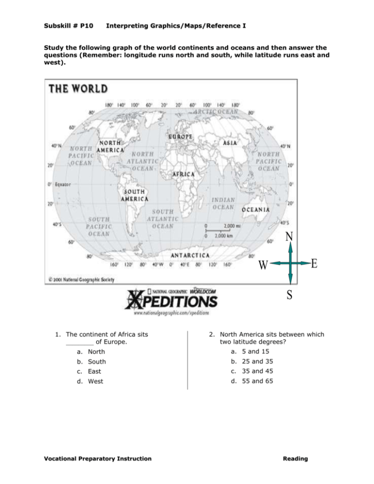
Subskill # P10 Interpreting Graphics/Maps/Reference I Study the following graph of the world continents and oceans and then answer the questions (Remember: longitude runs north and south, while latitude runs east and west). N E W S 1. The continent of Africa sits _________ of Europe. 2. North America sits between which two latitude degrees? a. North a. 5 and 15 b. South b. 25 and 35 c. East c. 35 and 45 d. West d. 55 and 65 Vocational Preparatory Instruction Reading Subskill # P10 Interpreting Graphics/Maps/Reference I 3. Which two continents intersect the zero longitude line? a. Africa and Europe 7. The equator intersects which two continents? b. Asia and South America a. North and South America c. North America and Africa b. Europe and Asia d. Asia and Oceania c. South America and Africa d. Europe and Africa 4. How many oceans are depicted on the map? a. 3 8. Antarctica is: b. 9 a. The southern most continent c. 6 b. The northern most continent d. 7 c. The eastern most continent d. The western most continent 5. Approximately how many kilometers are between the southern tip of North America and the Northern tip of South America? a. 3,000 b. 1,000 c. 4,000 d. 2,000 6. South America sits between which two latitudinal lines? a. 20S and 60S b. 20N and 60N c. 20N and 60S d. 20S and 60N Vocational Preparatory Instruction 9. How many latitudinal lines are shown on the map? a. 3 b. 9 c. 6 d. 7 10. How many longitudinal lines are shown on the map? a. 17 b. 16 c. 19 d. 18 Reading Subskill # P10 Interpreting Graphics/Maps/Reference I Answer Key 1. B 2. C 3. A 4. D 5. D 6. C 7. C 8. A 9. B 10. A Vocational Preparatory Instruction Reading

